

Missouri map
Nixa map
About 26,352 people live here (Census Bureau, 2024 estimate). The sheet's index lists 300 streets; North Massey Boulevard, South Main Street and West Mount Vernon Street cross the most grid squares. Also on it: Garrett Addition, Keltner Walker Addition and Nixa City Center Commons.
Open the map (PDF, US Letter)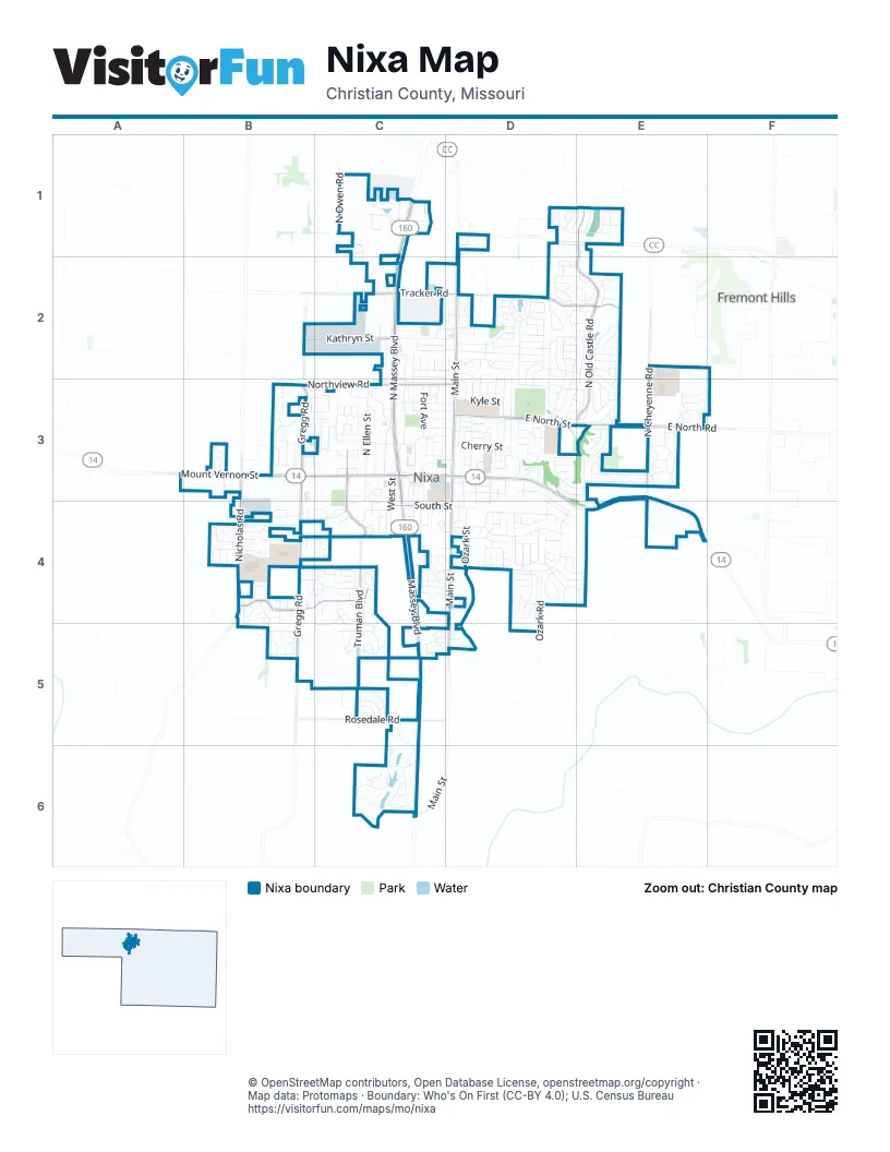
Street index of Nixa
Each street on the sheet and the grid squares it crosses.
- North Massey BoulevardC1, C2, C3, C4
- West Mount Vernon StreetB3, C3, D3
- Massey BoulevardC4, C5
- East Mount Vernon StreetD3, D4, E4
- North Main StreetD1, D2, D3
- North Old Castle RoadE1, E2, E3
- East North StreetD3, E3
- South Gregg RoadB3, B4, B5
- South Main StreetD3, D4, D5, C6
- South Truman BoulevardC4, C5
- East Tracker RoadD2, E2
- South Nicholas RoadB3, B4
- Butterfield DriveB4, C4
- North Gregg RoadB2, B3
- North Cheyenne RoadE3
- Northview RoadB3, C3, D3
- Kathryn StreetB2, C2
- West Tracker RoadC2, D2
- Truman BoulevardC3, C4
- Rosedale RoadC5
- West South StreetC4, D4
- East North RoadE3
- North Truman BoulevardC3
- North Nicholas RoadB3
- North Rockingham AvenueD2, E2, D3
- North Sandy Creek CircleD2
- McCroskey StreetC3
- South Kelby ParkwayC6
- East Scott Wayne DriveD2, E2
- Ozark RoadD4
- North Old Wilderness RoadC3
- East Gallup Hill RoadD4
- North Maplewood Hills RoadD2, D3
- North Ellen StreetC3
- East Kings Carriage BoulevardD4
- Wasson DriveC3
- South EastridgeD4
- North Foxhill CircleE2
- North Santa Monica DriveD2, D3
- Ozark StreetD4
- Old BittersweetD4
- South Elegant DriveD4
- East Ozark Jubilee DriveD2, E2
- North Galileo DriveE2, D3, E3
- Old Riverdale RoadD4, D5
- East Dyann DriveD2, E2
- North Jerico StreetE2, E3
- North Hightower AvenueD3
- North Hillcrest AvenueD3
- Frank StreetD2, D3
- East Slim Wilson BoulevardD2
- North Bluegill StreetD2, D3
- North Dunmore CircleD2
- West Verna LaneB4
- East Roubidoux StreetD3, E3
- West StreetC3, C4
- Kenneth StreetC2, C3
- South Parkside CircleD4
- Missouri AvenueD3
- North Taylor WayD2, D3
- West Pembrook AvenueB4, C4
- Aldersgate DriveC2, D2
- East Aspen DriveD2, D3
- South Harrison StreetC4
- Glen Oaks DriveB4, C4
- East Purple Martin StreetD1, E1
- Milton DriveC3
- South Silverwood LaneC4, C5
- Marketplace CrossingC5, C6
- East Crimson AvenueD3, D4
- Cherry StreetD3
- East Striper DriveD2, E2
- Peach BrookE3, D4
- East Lakota DriveE3
- Daisy Falls DriveE3
- Prospect AvenueD3
- North Cheyenne Valley RoadE3
- Eaglecrest StreetC2
- Fort AvenueC3
- Carriage CrossingD4
- Lorene StreetC3, D3
- Park StreetC3, D3
- South Ridgemont DriveD4
- North Walleye StreetD2
- Cobble Creek BoulevardD4
- Muskego RoadD4
- West Bentwater DriveC1
- West Aven StreetC3, D3
- Dustin LaneB4, C4
- East Weldon DriveD2, E2
- Rice StreetD3, D4
- North Spruce AvenueD3
- Elm StreetD3
- Estes StreetC3
- North Althea AvenueE2, E3
- North Owen RoadC1
- Kyle StreetD3
- Gerald DriveC2
- Tonya StreetC2, D2
- North Rich Hill CircleE2
- Saint Louis StreetD3
- Old Bittersweet CourtB4
- North Niangua DriveD3
- West Osage DriveC3
- Becky Circle NorthD3
- FairwayC3, C4
- East Riverton RoadE3
- East Spring Valley CircleD3
- Honeysuckle LaneC3
- West Brook Hollow RoadC5
- South Tiffany BoulevardD3, D4
- North Glengary DriveE3
- East Virginia LaneD4, E4
- East Katella CircleD2
- East Deanna LaneD2
- East Kings Mead CircleD2, E2
- West Elmwood CircleC4
- Yosemite DriveC3
- North Market StreetD3
- South Amber Ridge DriveC6
- White Ash RoadC5
- East Penzance CircleD2
- Gregory DriveC1
- East Grouse RoadD1, E1
- Bonda WayB3
- East Edenmore CircleD2, E2
- Chestnut RoadC5
- South Hickory LaneC4, C5
- East Acacia LaneD4, E4
- Pinhook DriveB4, B5
- North Gretchen StreetD2
- East Crystal AvenueD3, D4
- West Center CircleC3
- Croley BoulevardC4
- Gold Rush AvenueD4
- North Kilkenny WayE3
- West Donna Lewis CircleC4, D4
- Cambridge AvenueB4, C4
- Ellen StreetC3, C4
- North Montego StreetD2
- Birch StreetC4, C5
- Care AvenueB4
- Southeast Hills DriveD4
- South Southgate StreetC4
- Smalley StreetD3, D4
- Devonshire StreetD4
- West Bryant StreetC4
- East Meramac LaneD3
- Raintree StreetC2, D2
- Hillside DriveC4, D4
- Southridge StreetD4
- North Baywood DriveE3
- Linwood AvenueC4
- South Waterstone BendC6
- Shady Oak CircleC5, D5
- South Rosemoor DriveC5, C6
- West Savannah CircleC6
- State StreetC3, D3
- Sunrise DriveC5, D5
- Briarwood LaneC3
- West Arbor Glenn DriveC4, C5
- South Water StreetD3, D4
- Village Center StreetC3, C4
- Aven AvenueC3, D3
- Dabney AvenueC2, C3
- South Delaware StreetC3, C4
- Pinehill CourtC4, D4
- South Market StreetD3, D4
- Scenic Hills DriveB5
- Bates DriveB4, C4
- North Maxine AvenueD2
- North Greer AvenueE2, E3
- Delaware Street NorthC3
- Bradford AvenueD4
- SterlingC4
- East Beaufort StreetD2, E2
- North Spout Spring StreetE3
- Westview DriveC2
- West Inman RoadB5
- West Sherman WayC2, D2
- Denali DriveB3, C3
- Hawthorne DriveC3
- Mining Camp RoadD4
- North Allison StreetD2, D3
- Persimmon DriveC3
- West Meason AvenueC1
- Crestwood StreetB4, C4
- Mills RoadD4
- Rippling Creek RoadD3, E3
- Pinewood LaneB4, B5
- Cynthia DriveC2
- Eastwood DriveD3
- West Bridgewood PlaceB4
- Great River DriveB5
- Northview DriveC2, C3
- East Notting Hill GateD4
- Ballard StreetB5
- Ridgecrest AvenueD4
- East Hayston AvenueE3
- North Dunbar DriveE3
- East Downshire DriveE2
- Great Plains StreetE3
- West Vintage LaneB4
- North Alexandria StreetD3, E3
- Brook ForestD3
- West Jackson AvenueC1
- Sequoia DriveC3
- Bryce StreetB3, C3
- Deerfield DriveC2, D2
- Avalon StreetB3
- Fort StreetC3, C4
- HackberryC4
- North Eagle Park DriveB3
- Hunter DriveC2, D2
- McConnel StreetC3, D3
- LivingstonC4
- W Everwood WayC6
- Wexford WayE2
- Woodcastle RoadB4
- North Dublin DriveE3
- North Pinnacle AvenueD1
- Walnut StreetC3, D3
- Bryce LaneB3
- Country Ridge StreetD3
- East Turtle Rock RoadE3
- Marie StreetB3
- East Donegal CircleD2
- Myra DriveC1
- Foxx DriveB4, B5
- W Declan CtC6
- East South StreetD4
- Nixa Park RoadC3
- East Barracuda DriveD2
- Ballard DriveB4
- Apple RidgeD4
- Baldknobber StreetD4
- Meadow StreetB3
- North Carnegie RoadE1
- East Lakota StreetE3
- East Welch StreetE3
- Bryan DriveC2
- East Tarpon RoadD2
- North Wicklow RoadD2
- East Grafton RoadE2
- Brook Forest RoadD3, E3
- Canterbury LaneD4
- West Castor LoopC5
- North Feather Crest DriveD1, E1
- Lynn StreetD3, D4
- North Ritter AvenueE3
- Redwood StreetB5
- North Eagle Valley LaneE1
- Roberts StreetC4
- Big Horn RoadE3
- North Clover CourtC3
- South James StreetC4
- North Mallard DriveE1
- West Trail Point DriveC4
- Peachtree DriveD2
- East Ashford DriveE3
- South Wheaton Hills DriveE4
- East Thorndale DriveE2
- East Montarosa StreetD3, E3
- Morning Glory DriveC3
- Timber Ridge DriveC4, C5
- Pepper Hill DriveB4
- Eagle StreetD4
- Coventry StreetC3
- North Falcon Crest CourtC2
- East Stone Crest DriveD4, E4
- North Tucker Bay CircleE3
- Lantern RidgeD4
- Paddington LaneC4
- West Monarchwood DriveC6
- Bluegrass RoadB4
- W Stone House RoadB3
- Cedar Heights DriveB3
- Southgate DriveC4
- Pinehurst StreetB4
- West Sweetwater LaneC5
- Patricia Avenue SouthC3, C4
- East Baracuda DriveD2, E2
- New StreetC3
- Sunset AvenueD4
- East Sparrow RoadE1
- South Chestnut Hill LaneC5
- Pheasant RunC2
- Hill StreetD3
- West Tower StreetC3
- Lone Oak AvenueD3
- Placer Mill RoadD4
- North Clayton StreetD2
- Elderberry LaneC3
- Kentwood AvenueC3, D3
- North Evergreen AvenueD3
- Fairway Street NorthC3
- North Arlington StreetD2
- West Silver Oak StreetC4
- North Montclair WayE3
- Silver Streak RoadD4
Places on the map
- Aldersgate Church
- Aldi
- Applebee's
- AutoZone
- Braum's
- Casey's General Store
- Century Elementary
- Conoco
- CoxHealth Urgent Care Nixa
- CVS Pharmacy
- Daisy's Imagination Station
- Dollar General
- Eagle Stadium
- First Baptist Church
- Garrett Addition
- John Thomas School of Discovery
- Keltner Walker Addition
- Little Caesars
- Magers Subdivisionb
- Mathews Elementary School
- McCauley Park
- Mercy Clinic Pediatrics
- Nixa City Center Commons
- Nixa City Hall
- Nixa Commerce Center
- Nixa Community Branch Library
- Nixa High School
- Nixa Junior High School
- Nixa Police Department
- North Old Castle Road
- OakStar Bank
- Ozark Bank
- Price Cutter
- Rotary Park
- Sonic
- Southern Bank
- Super 8 by Wyndham Nixa/Springfield Area
- The Gardens at Woodfield
- The X Center
- Wasson Commercial Development
Next to Nixa
- Cassidy
- Fremont Hills
© OpenStreetMap contributors, Open Database License, openstreetmap.org/copyright · Map data: Protomaps · Boundary: Who's On First (CC-BY 4.0); U.S. Census Bureau















