

Missouri map
Raytown map
About 29,244 people live here (Census Bureau, 2024 estimate). The sheet's index lists 233 streets; Harvard Avenue, Harris Avenue and Sterling Avenue cross the most grid squares. Also on it: Mount Olivet Cemetery, Raytown Equestrian Park and Wildwood Lake.
Open the map (PDF, US Letter)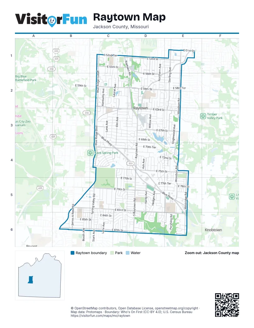
Street index of Raytown
Each street on the sheet and the grid squares it crosses.
- Blue Ridge CutoffC1, C2, C3
- Crescent AvenueC1, C2, C5, C6
- Ditzler AvenueC1, C2, C3, C4, C5, C6
- East 52nd TerraceC1
- East 53rd PlaceC1
- East 53rd StreetC1, D1, E1
- East 53rd TerraceC1, D1, E1
- East 54th StreetC1, D1, E1
- East 54th TerraceC1, D1, E1
- East 55th StreetC1, D1, E1
- East 55th TerraceC1, E1
- East 56th TerraceC1, C2, D2, E2
- Elm AvenueC1, C2, C3, C4, C5, C6
- Elm PlaceC1
- Hunter StreetC1, C2, C3, C4
- Hunter TerraceC1, C2
- Kentucky AvenueC1, C2, C3, C4, C5, C6
- Lane AvenueC1, C2, C3, C5, C6
- Laurel AvenueC1, C2, C3, C4, C5, C6
- Manning AvenueC1, C2, C3, C5, C6
- Oxford AvenueC1, C2, C3, C4, C6
- Raytown RoadC1, D1, D2, D3, D4
- Appleton AvenueD1, D2, D3, D4, E4, D5
- Ash AvenueD1, D2, D3, D4, D5, D6
- Cedar AvenueD1, D2, D3, D4, D5
- East 53 StreetD1
- East 56th StreetD1, D2, E2
- Hardy AvenueD1, D2, D3, D4, D5
- Hardy CourtD1
- Harris AvenueD1, E1, D2, E2, D3, D4, D5, D6
- Hedges AvenueD1, D2, D3, D4, D5, D6
- Maywood AvenueD1, D2, D3, D4, D5, D6
- Northern AvenueD1, D2, D3
- Pittman RoadD1
- Ralston AvenueD1, D2, D3, D4
- Willow AvenueD1, D2, D3, D4
- Blue Ridge BoulevardE1, D2, E2, C3, D3, C4
- Crisp AvenueE1, E2, E3, E4, E5
- East 51st StreetE1
- Harvard AvenueE1, E2, D3, E3, D4, E4, D5, E5, D6
- Hidden Lake DriveE1
- Norwood AvenueE1, E4
- Ridgeway AvenueE1, E5
- Sterling AvenueE1, E2, E3, E4, E5, D6, E6
- Westridge CircleE1
- Woodson RoadE1, E2, E3, E4, E5
- East 57th CourtC2
- East 57th StreetC2, D2, E2
- East 57th TerraceC2, D2, E2
- East 58th StreetC2, D2, E2
- East 58th TerraceC2, D2, E2
- East 59th StreetC2, D2, E2
- East 59th TerraceC2, D2, E2
- East 60th StreetC2, D2, E2
- East 60th TerraceC2, D2, E2
- East 61 StreetC2
- East 61st StreetC2, D2, E2
- East 61st TerraceC2, D2, E2
- East 62nd StreetC2, D2, E2
- East 62nd TerraceC2, D2, E3
- East 63rd StreetC2, C3, D3, E3
- Farley AvenueC2, C3
- Hunter CourtC2
- 57th PlaceD2
- Arlington AvenueD2, C3, D3, C4, C5, C6
- Ash CourtD2, D3
- Cedar StreetD2
- East 57 PlaceD2
- East 57 StreetD2
- East 60 StreetD2
- East 62 StreetD2
- East 63rd Plaza CourtD2, D3
- Hadley StreetD2, D3
- Overton AvenueD2, D3, D4, D5, D6
- Raytown TrafficwayD2, D3
- Claremont AvenueE2, E3
- East 58 StreetE2
- Englewood AvenueE2, E3, E4, E5
- Blue ParkwayC3, C4, D4, D5, E5, E6
- East 64th StreetC3, D3, E3
- East 64th TerraceC3, D3, E3
- East 65th StreetC3, D3, E3
- East 65th TerraceC3, D3, E3
- East 66th StreetC3, D3
- East 66th TerraceC3, D3, E3
- East 67th StreetC3, D3, E3
- East 67th TerraceC3, D3, E3
- East 68th StreetC3, D3
- East 68th TerraceC3, D3
- East 69th StreetC3, D3, E3, E4
- East 69th TerraceC3, D3, C4, D4
- Maple AvenueC3, C4, C5, C6
- Private DriveC3, D3, D4, E4
- Rose LaneC3
- Brook LaneD3, D4
- Dam Access Road (private)D3
- East 63rd TerraceD3
- East 64 TerraceD3
- East 66 StreetD3
- East 66 TerraceD3
- Evanston AvenueD3, C4, D4, C5, D5, C6, D6
- Hawthorne AvenueD3, D4, D5, D6
- Lakeshore CourtD3
- Lakeshore DriveD3, D4, E4
- Lakeview DriveD3, E3
- Plymouth LaneD3
- Railroad StreetD3
- South Gregory Lake RoadD3, E3
- East 67 StreetE3
- Little Blue RoadE3
- Norwood CourtE3
- Vermont AvenueE3
- Wildwood DriveE3, E4
- Buckingham LaneC4
- Crescent DriveC4
- East 70th TerraceC4, D4
- East 71st TerraceC4, D4, E4
- East 72nd StreetC4, D4, E4
- East 72nd TerraceC4, D4, E4
- East 73rd StreetC4, D4, E4
- East 73rd TerraceC4
- East 74th StreetC4, D4, E4
- East 74th TerraceC4, D4, E4
- East 75th StreetC4, D4, E4
- East 76th TerraceC4, D4, E5
- East Gregory BoulevardC4, D4
- Hunter AvenueC4, C5, C6
- Maple DriveC4
- Maple LaneC4
- Richard DriveC4
- Richards CircleC4
- Vaughn AvenueC4
- East 70th StreetD4
- East 70th Street TerraceD4
- East 71 TerraceD4
- HarvardD4, E4
- Harvard DriveD4
- Lewis AvenueD4, D5
- RalstonD4
- Rice AvenueD4
- South Raytown RoadD4, D5, D6
- Walmart DriveD4, D5
- 71st Street DriveE4
- CrispE4, E5
- East 71 DriveE4
- East 71st CourtE4
- East 71st StreetE4
- East 71st Street DriveE4
- East 74th Street CourtE4
- East 75th TerraceE4
- East 76th StreetE4
- EnglewoodE4, E5
- Englewood LaneE4
- Irwin RoadE4
- Westridge RoadE4, E5, E6
- Woodson DriveE4, E5, E6
- Booth AvenueB5, B6
- East 80th TerraceB5, C5, D5
- East 81st StreetB5, C5, D5
- East 81st TerraceB5, C5, D5
- East 83rd StreetB5, C5, D5, D6, E6
- East 83rd TerraceB5, C5, D6
- East 83rd TerrraceB5
- Greenwood RoadB5, B6
- James A Reed RoadB5, B6
- Marsh AvenueB5, B6
- East 77th StreetC5, D5, E5
- East 77th TerraceC5, D5, E5
- East 79th StreetC5, D5, E5
- East 79th TerraceC5, D5
- East 80th StreetC5, D5
- East 81 StreetC5, D5
- East 82nd StreetC5, D5, E5
- East 82nd TerraceC5, D5
- Spring Valley RoadC5, C6
- Stark AvenueC5, C6
- Tennessee AvenueC5, C6
- Ash LakeD5
- East 78th StreetD5, E5
- East 78th TerraceD5, E5
- East 79th PlaceD5
- East Harris CourtD5
- East LewisD5
- HarrisD5
- Harris BoulevardD5
- Northern StreetD5, D6
- Willow WayD5, D6
- 82nd CourtE5
- East 77 TerraceE5
- East 78th PlaceE5
- East Frost RoadE5
- IrwinE5
- Jessica LaneE5
- Vassar AvenueE5, E6
- Ditman AvenueB6
- East 84th StreetB6, C6, D6
- East 84th TerraceB6, C6, D6, E6
- East 85th StreetB6, C6, D6, E6
- East 85th TerraceB6, C6, D6, E6
- East 86th StreetB6, C6, E6
- East 86th TerraceB6, C6, D6, E6
- East 87th StreetB6, C6, D6, E6
- East 88th StreetB6
- Everett StreetB6
- Ford AvenueB6, C6
- ManchesterB6
- 83rd TerraceC6
- 84th Street CourtC6
- 85th PlaceC6
- East 83rd PlaceC6
- East 85 StreetC6
- East 85th PlaceC6
- East 85th TerrraceC6
- East Utopia DriveC6
- Glenwood AvenueC6
- Lane DriveC6
- Lane PlaceC6
- Utopia DriveC6
- Utopia ParkwayC6
- West Longview ParkwayC6
- West Utopia DriveC6
- East 84 StreetD6
- Harvard TerraceD6
- Hawthorne PlaceD6
- Military Club RoadD6
- 86th StreetE6
- 86th TerraceE6
- East 83 StreetE6
- Grant DriveE6
- Pershing RoadE6
- Ridgeway CourtE6
- Woodson CourtE6
- Woodson PlaceE6
Places on the map
- Ace Hardware
- Aldi
- Bickford Assisted Living
- Blue Ridge Elementary School
- Blue Ridge Plaza
- Blue Ridge Presbyterian Church
- Blue Ridge Trinity Lutheran Church
- Burger King
- Chipotle
- Church of Christ of Raytown
- Community of Christ Church
- Connection Point Church
- CVS Pharmacy
- Dollar General
- Eclipse Bar & Grill
- Elm Lake
- First United Methodist Church
- Freddy's
- Hy-Vee
- IHOP
- Kenagy Park
- Kritser Park
- Laurel Hills Elementary School
- Maple Drive
- McDonald's
- Mid-Continent Public Library - Raytown Branch
- Mount Carmel Cemetery
- Mount Olivet Cemetery
- Raytown Equestrian Park
- Raytown High School
- Raytown Post Office
- Raytown South High School
- Raytown South Middle School
- Sarah Colman-Livengood Park
- Southwood Elementary School
- Southwood Park
- Walmart Supercenter
- Wildwood Lake
- Woodson Village
Next to Raytown
- Bryant
- Knobtown
© OpenStreetMap contributors, Open Database License, openstreetmap.org/copyright · Map data: Protomaps · Boundary: Who's On First (CC-BY 4.0); U.S. Census Bureau















