

Missouri map
Sedalia map
About 22,310 people live here (Census Bureau, 2024 estimate). The sheet's index lists 300 streets; West Broadway Boulevard, East Broadway Boulevard and West Main Street cross the most grid squares. Things to do inside the boundary: Scott Joplin International Ragtime Festival.
Open the map (PDF, US Letter)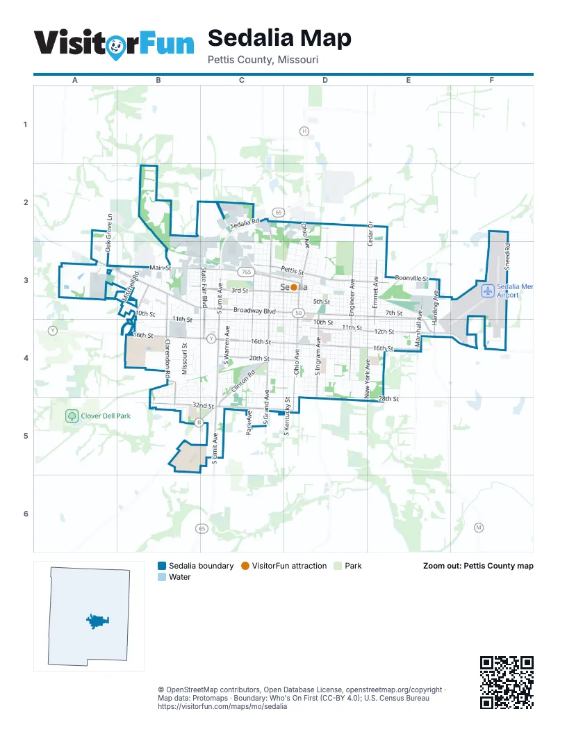
Street index of Sedalia
Each street on the sheet and the grid squares it crosses.
- West Broadway BoulevardA3, B3, C3, D3
- South Limit AvenueC3, C4, C5
- East Broadway BoulevardD3, E3, E4, F4
- West 16th StreetB4, C4, D4
- West Main StreetA3, B3, C3, D3
- South Ohio AvenueD3, D4, D5
- East 16th StreetD4, E4
- South Ingram AvenueD3, D4
- North Ohio AvenueD2, D3
- Harding AvenueE3, E4
- Thompson BoulevardB3, B4
- Greenridge RoadB5, C5
- South Grand AvenueC3, C4, C5
- West 32nd StreetB5, C5, D5
- East 12th StreetD4, E4
- West 3rd StreetB3, C3, D3
- South State Fair BoulevardC3, C4
- South Park AvenueC3, C4, C5
- South Engineer AvenueD3, D4
- West 20th StreetC4, D4
- Clarendon RoadB4, B5
- Clinton RoadC4, C5
- North Engineer AvenueD2, D3
- Georgetown RoadC2, C3
- South Marshall AvenueE3, E4
- Winchester RoadB3, B4
- West Pettis StreetC3, D3
- East Saline StreetD3, E3
- North Emmet AvenueE3
- South Emmet AvenueE3, E4
- East Pettis StreetD3
- West Saline StreetD3
- Grand AvenueC3
- South Kentucky StreetD3, D4, D5
- South New York AvenueD3, E3, E4, E5
- West 10th StreetB3, C3, C4, D4
- West 11th StreetB3, B4, C4, D4
- East 10th StreetD4, E4
- South Stewart AvenueC3, C4, C5
- East 9th StreetD3, D4, E4
- South Quincy AvenueC3, C4
- East 7th StreetD3, E3
- East 14th StreetD4, E4
- South Washington AvenueD3, D4
- South Missouri AvenueC3, C4
- West 5th StreetB3, C3, D3
- East 5th StreetD3, E3
- South Harrison AvenueC3, C4
- West 14th StreetC4, D4
- West 4th StreetC3, D3
- East 6th StreetD3, E3
- South Marvin AvenueD3, D4
- East Boonville StreetD3, E3
- South Moniteau AvenueD3, C4, D4
- East 11th StreetD4, E4
- East 15th StreetD4, E4
- West 9th StreetC3, D3
- South Osage AvenueD3, D4
- South Warren AvenueC3, C4
- East 13th StreetD4, E4
- West 18th StreetC4, D4
- South Lamine AvenueD3, D4
- South Lafayette AvenueD3, D4
- East 24th StreetD4, E4
- Southwest BoulevardB4, B5
- South Vermont AvenueC3, D3, C4
- East 4th StreetD3, E3
- South Summit AvenueD3, D4
- East Howard StreetD3, E3
- South Montgomery AvenueD3, D4
- East 3rd StreetD3
- South Wagner AvenueD3, D4
- South Carr AvenueC3, C4
- South Barrett AvenueC3, C4
- South Beacon AvenueC3, C4
- West 7th StreetC3, D3
- South Hancock AvenueD3, D4
- West 2nd StreetB3, C3, D3
- South Prospect AvenueC3, C4
- South Sneed AvenueC3, C4
- East 19th StreetD4
- North Missouri AvenueD2, C3, D3
- West Henry StreetC2, C3, D3
- West 6th StreetC3, D3
- South Brown AvenueD3, D4
- East 17th StreetD4
- South Center AvenueD3, D4
- West Cooper StreetC3, D3
- Cedar DriveE2, E3
- Sneed RoadF2, F3
- South MassachusettsD3, D4
- West 24th StreetC4, D4
- Main Street RoadA3
- East 28th StreetD4, E5
- East 18th StreetD4
- South Garfield AvenueE3, E4
- South Arlington AvenueE3, E4
- West Morgan StreetC3, D3
- Cherry Tree LaneB2, C2
- Missouri StreetB4
- Mitchell RoadB3
- Liberty Park BoulevardC3
- Main StreetB4
- South Madison AvenueE3, E4
- Plaza AvenueB5, C5
- Tiger Pride BoulevardB5, C5
- South Murray AvenueE3, E4
- Griessen RoadE2, F2
- Oak Grove LaneA2, A3
- North Osage AvenueD2, D3
- Missouri State Fair BoulevardB4, C4
- William Parkhurst DriveC2, C3
- Anderson AvenueB4, B5
- East 20th StreetD4
- West Johnson StreetC3, D3
- South Mildred AvenueE3, E4
- Wilkerson StreetC3, D3
- Wing AvenueB4, B5
- State Fairgrounds RacetrackB4, C4
- Industrial RoadB3
- South Porter AvenueD3, D4
- Tower StreetD3, E3
- East Jackson StreetD3, E3
- East Chestnut StreetD3, E3
- East Walnut StreetD3, E3
- North New York AvenueE3
- North State Fair BoulevardC2, C3
- Sedalia RoadC2
- North Lamine AvenueD3
- South Thompson AvenueD3, D4
- Leroy Vandyke AvenueA3, B3
- North Park AvenueC3
- Sacajawea RoadB5
- North Heard AvenueE3
- Heard AvenueE2, E3
- West 17th StreetC4, D4
- West 15th StreetC4, D4
- Speed AvenueB4, C4
- Depp AvenueE3
- Mfa RoadC3
- Gentry AvenueC3
- East Harvey StreetE3, F3
- North Hill AvenueD3
- West Jefferson StreetC3, D3
- North Prospect AvenueC3
- North Quincy AvenueC3
- East 26th StreetD4
- South Babcock AvenueE3, E4
- Spring StreetC3
- North Washington AvenueD3
- Veterans Memorial DriveD3
- North Moniteau AvenueD3
- East 22nd StreetD4, E4
- Brentwood AvenueC5
- Adams RoadC2
- North Stewart AvenueC3
- South Woodlawn DriveB3, C3
- Ewing DriveC2
- West 13th StreetC4, D4
- Payless DriveC2, C3
- West 28th StreetC4, D4
- West 12th StreetB4, D4
- Curry DriveA3
- Thompson RoadB3
- West 1st StreetB3, C3
- West 1st Street TerraceB3, C3
- Skyline DriveB4, B5
- Maple StreetB4
- Collins AvenueD4
- West Benton StreetC3, D3
- East 27th StreetD4
- East 2nd StreetD3
- Elm StreetB4
- Dundee AvenueC3
- Stephenson AvenueB4
- Herold AvenueB3, B4
- West AvenueB3
- Highland AvenueB4
- South Merriam AvenueE3, E4
- Sue LaneB3, B4
- East Main StreetD3
- Duke RoadB3
- Crescent DriveE3, E4
- Royal BoulevardB3, B4
- Heck AvenueC4
- South Monroe AvenueE3, E4
- Brianna BoulevardB4
- Brandon AvenueC4, C5
- West 2nd Street TerraceB3, C3
- Cunningham DriveB5
- Lamm DriveB3
- Massechusett AvenueD4
- South Harding AvenueE3
- Boonville RoadF3
- East 25th StreetD4
- Magnolia StreetC4, D4
- North Woodlawn DriveB3, C3
- Ruth Ann DriveB3
- Katy CircleB4
- Market StreetC2
- South Collins AvenueD4
- West 23rd StreetC4
- West Clay StreetD3
- Water Tower RoadB4
- Waterloo RoadC2
- Leone AvenueB3
- Sylvia DriveB3
- Country Club BoulevardC4
- Metallic RoadB3
- Buckingham DriveB5
- East Saint Louis StreetD3
- Rainbow DriveB3, C3
- West 19th StreetD4
- East Hamm StreetD3
- Matthew DriveC4
- New England DriveC4
- Rival AvenueC5
- Erika AvenueC4, C5
- Westwood DriveB3
- North Broadway BoulevardD2
- James RoadC4, C5
- Dennis RoadB3, C3
- Kay AvenueB3, C3
- Sellers RoadE4
- East Jefferson StreetD3
- East Morgan StreetD3
- Lima AlleyD3
- East Cooper StreetD3
- East Johnson StreetD3
- Mill StreetD3
- Daryl DriveB3
- La Grand AvenueC4
- Olsen RoadB3
- Driftwood DriveC4
- Katy Trail AvenueB4, B5
- Golf DriveC5
- West Pacific StreetD3
- Ware AvenueE4
- North Hurley AvenueD3
- North Summit AvenueD3
- Honeysuckle RoadC4
- Poplar PlaceC4
- Sharon LaneC5
- Manor CourtC5
- East RoadC2
- Prestwick Farms RoadF4
- Bristol LaneD4
- Sunset DriveC3
- Moniteau AvenueD3
- Albert Lee AvenueB4
- Cambridge DriveB5
- Sunset VillageA3, B3
- Gould StreetE3
- Margaret AvenueB4
- North Marshall AvenueE3
- Clarke AvenueE3
- Ammon DriveB4
- Leigh LaneF4
- West Howard StreetD3
- Normandy RoadB3
- Gregory LaneC4, C5
- Highway DriveC4, C5
- 2nd StreetB3
- Sweet William LaneB5
- Jerome DriveC4, C5
- Colonial CourtC4
- Douglas LaneC5
- Keith Allen DriveC4, C5
- Greenwood LaneC4
- Dyke AvenueB3
- East Hogan StreetD3
- Reine AvenueD2
- Stacey LaneC4
- Devin DriveB4
- Station AvenueB4
- Stone Creek DriveB4
- Thompson AvenueD4
- Wabash StreetB4, B5
- Wild Rose LaneD4
- West 22nd StreetC4, D4
- Air Center CircleF4
- West Boonville StreetD3
- Aaron AvenueC5
- Dal-Whi-Mo CourtC3
- Ivey LaneF4
- Olive AvenueC4
- Eagle View DriveC2
- Griffith AvenueB3
- Watson StreetE3
- Ensign DriveB4
- Woods AvenueB4
- Deseret RoadB4
- East 32nd StreetD5
- Killion DriveD4
- South VermontC4
- Brandon TerraceC4
- Matz CircleB4
- East 21st StreetD4
- Fairview CourtC4
- Eagler Veiw DriveC2
Things to do on the Sedalia map
Places on the map
- Advance Auto Parts
- Air Center Circle
- ALDI
- American Inn Sedalia Missouri Hotel
- Antioch Fellowship Church
- Anytime Fitness
- B&B Theatres Sedalia Galaxy 10
- Best Western State Fair Inn
- Blue Young Field
- Bob Case Field
- Boonslick Regional Library
- Bothwell Regional Health Center
- Broadway Baptist Church
- Broadway Presbyterian Church
- Burger King
- Calvary Episcopal Church
- Casey's General Store
- Centennial Park
- Centennial Pool
- Central Bank
- Crown Hill Cemetery
- Donald C. Proctor Library
- Hubbard Park
- Katy Park
- Liberty Park
- Lowe's
- Memorial Park Cemetery
- Menards
- Missouri State Fair Public Campground
- Missouri State Fairground
- Parkview Elementary School
- Sedalia Memorial Airport
- Sedalia Middle School
- Sedalia Smith-Cotton High School
- Skyline Elementary School
- State Fair Shopping Center
- State Fairgrounds Racetrack
- The UPS Store
- Thompson Hills Shopping Center
- Walmart Supercenter
© OpenStreetMap contributors, Open Database License, openstreetmap.org/copyright · Map data: Protomaps · Boundary: Who's On First (CC-BY 4.0); U.S. Census Bureau















