

Mississippi road map
I-22 in Mississippi map
I-22 is about 104 miles in Mississippi. It has 29 exits, from Exit 12A-B at mile 1 to Exit 113 at mile 100. It meets 18 highways; MS 178, US 78 and I-269 meet it in the most grid squares.
Open the map (PDF, US Letter)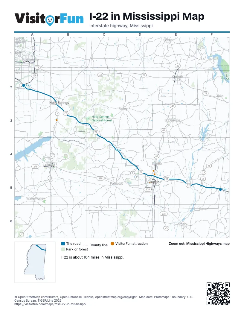
Exits on I-22 in Mississippi
Each exit in mile order, with its grid square.
- Exit 12A-Bmile 1, A2
- Exit 14mile 3, A2
- Exit 18mile 6, A2
- Exit 21mile 10, A2
- Exit 26mile 14, B2
- Exit 30mile 19, B3
- Exit 37mile 26, B3
- Exit 41mile 30, B3
- Exit 48mile 36, C3
- Exit 55mile 43, C3
- Exit 60mile 48, C4
- Exit 61mile 49, C4
- Exit 63mile 51, C4
- Exit 64mile 52, C4
- Exit 73mile 61, D4
- Exit 76mile 64, D4
- Exit 81mile 68, D5
- Exit 82mile 70, D5
- Exit 85mile 72, D5
- Exit 86Amile 73, D5
- Exit 86Bmile 74, D5
- Exit 87mile 74, D5
- Exit 90mile 77, E5
- Exit 94mile 81, E5
- Exit 97mile 84, E5
- Exit 101mile 88, E5
- Exit 104mile 91, E5
- Exit 108mile 95, F5
- Exit 113mile 100, F5
Highways I-22 meets
Each highway it meets and the grid squares where they meet.
- I-269A2
- US 78A2, F5
- MS 304A2
- MS 309A2
- MS 737A2
- MS 7B3
- MS 4B3
- MS 705C3
- MS 178C3, D5, E5, F5
- MS 30C4
- MS 15C4
- MS 9D4
- MS 778D4
- US 45D5
- MS 145D5
- MS 371E5
- MS 25F5
- MS 23F5
Towns along I-22 in Mississippi
In mile order, with the grid square of each.
- Byhaliamile 0, A2
- Victoriamile 5, A2
- Red Banksmile 9, A2
- Holly Springsmile 15, B2
- Potts Campmile 29, B3
- Hickory Flatmile 36, C3
- Myrtlemile 42, C3
- New Albanymile 47, C4
- Blue Springsmile 59, D4
- Shermanmile 63, D4
- Tupelomile 67, D5
- Moorevillemile 80, E5
- Mantachiemile 84, E5
- Fultonmile 90, E5
- Tremontmile 99, F5
Things to do on the I-22 in Mississippi map
© OpenStreetMap contributors, Open Database License, openstreetmap.org/copyright · Map data: Protomaps · Boundary: U.S. Census Bureau, TIGER/Line 2026















