

Mississippi road map
Mississippi highway map
9 Interstate routes run about 843 miles in Mississippi, each on a sheet of its own. The sheet's index lists 37 highways; I-55, US 82 and US 278 cross the most grid squares. Towns on it: Jackson, Gulfport and Southaven.
Open the map (PDF, US Letter)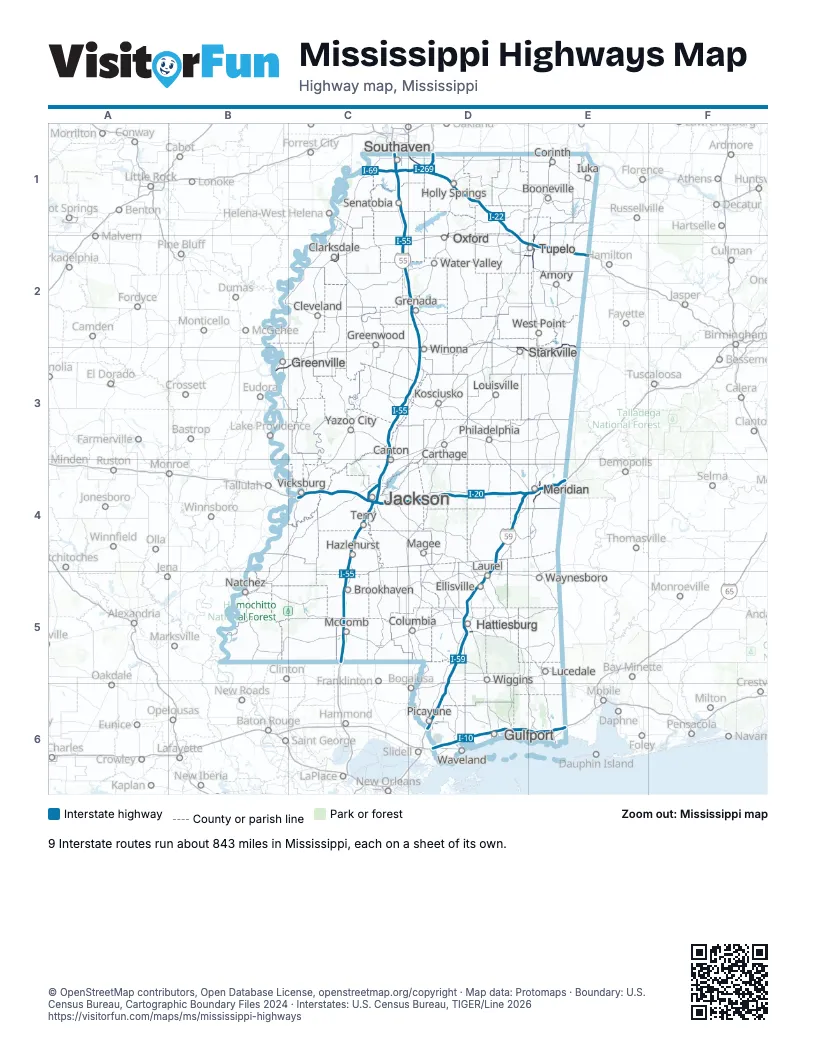
Road maps of Mississippi
9 road maps: each Interstate and byway on a sheet of its own.
Highway index of Mississippi
Each highway on the sheet and the grid squares it crosses.
- I-10D6, E6
- I-20C4, D4, E4
- I-22D1, D2, E2
- I-55C1, C2, C3, C4, C5, D2, D3
- I-59D4, D5, D6, E4
- I-69C1
- I-110D6
- I-220C4
- I-269C1, D1
- US 11D6, E4
- US 45E1, E2, E3, E4
- US 49C2, C4
- US 51C4
- US 61C2, C4
- US 78C1, D1, D2, E2
- US 80C4, D4, E4
- US 82B3, C3, D3, E2, E3
- US 84D5
- US 98C5, D5
- US 278B3, C2, C3, D2, E2
- MS 2E1
- MS 6D2, E2
- MS 7D1, D2
- MS 9D1, D2
- MS 12D3, E2, E3
- MS 15D5, D6
- MS 19E4
- MS 25D3, E2, E3
- MS 30D1
- MS 42D5
- MS 43D6
- MS 50E2
- MS 67D6
- MS 178E2
- MS 304C1, D1
- MS 322C2
- MS 713C1
Places on the map
- Amory
- Booneville
- Brookhaven
- Canton
- Carthage
- Clarksdale
- Cleveland
- Columbia
- Corinth
- Ellisville
- Greenville
- Greenwood
- Grenada
- Gulfport
- Hattiesburg
- Hazlehurst
- Holly Springs
- Iuka
- Jackson
- Kosciusko
- Laurel
- Louisville
- Lucedale
- Magee
- McComb
- Meridian
- Natchez
- Oxford
- Philadelphia
- Picayune
- Senatobia
- Southaven
- Starkville
- Terry
- Tupelo
- Vicksburg
- Water Valley
- Waveland
- Waynesboro
- West Point
- Wiggins
- Winona
- Yazoo City
© OpenStreetMap contributors, Open Database License, openstreetmap.org/copyright · Map data: Protomaps · Boundary: U.S. Census Bureau, Cartographic Boundary Files 2024 · Interstates: U.S. Census Bureau, TIGER/Line 2026















