

Montana map
Big Horn County map
About 12,796 people live here (Census Bureau, 2024 estimate). The sheet's index lists 300 streets; Sarpy Road, 3rd Street and Frontage Road cross the most grid squares. Things to do inside the boundary: Little Bighorn Battlefield National Monument and Bighorn Canyon National Recreation Area.
Open the map (PDF, US Letter)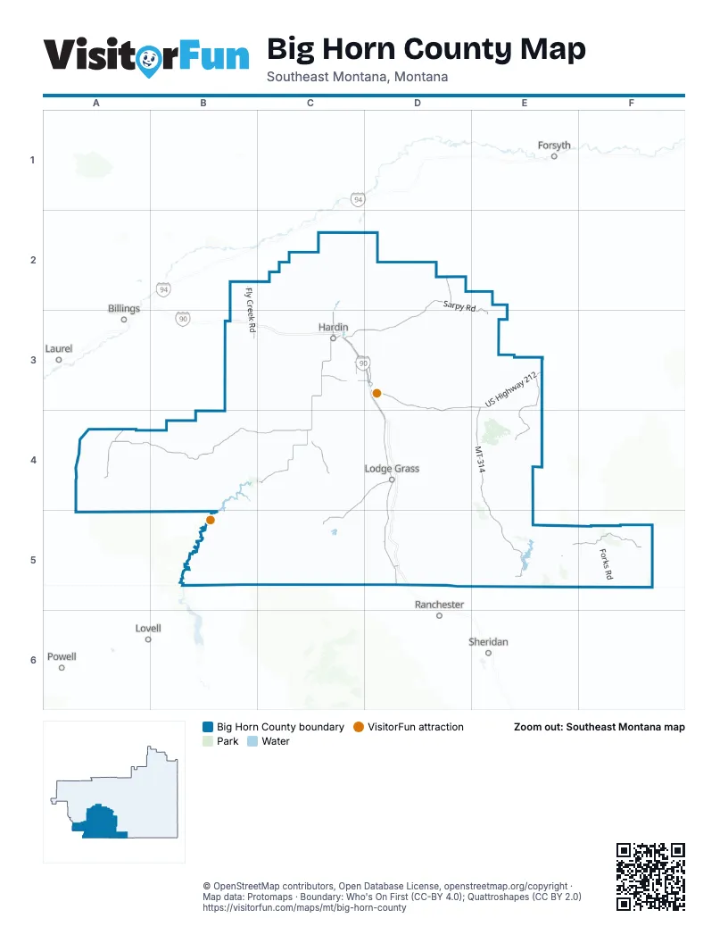
Street index of Big Horn County
Each street on the sheet and the grid squares it crosses.
- US Highway 212D3, E3, D4
- North Center AvenueC3
- Old United States Highway 87C3
- 14th Street WestC3
- East Railroad StreetC3
- 3rd Street EastC3
- Frontage RoadC3, D3, D4, D5
- Pryor-St. Xavier Cut AcrossA4, B4, C4
- Sarpy RoadD2, E2, C3, D3, E3
- Secondary State Highway 313C3, C4
- MT 314E3, E4, E5
- Decker RoadE5, F5
- Crow-Saint Xavier CutoffC3
- Highway 47C3
- Crow-Saint Xavier RoadC3, D3
- Pryor Creek RoadA4
- 3rd StreetC3, D3, E3, B4, C4
- Secondary State Highway Highway 313C3
- North Crawford AvenueC3
- North Mitchell AvenueC3
- South Mitchell AvenueC3
- Mak Pua AvenueA4
- 3rd Street WestC3
- Muddy Creek RoadE3, E4
- Fly Creek RoadB2, B3
- Mountain Crow RoadC3, D3
- Good Luck RoadC4, C5
- Pryor Gap RoadA4
- County Highway 463C4, C5
- Highway 463C4, D4
- Crow River RoadC3, D3
- Bala StreetD3
- Makawasha AvenueD3
- Heritage RoadD3
- Aberdeen RoadD5
- County Road 463C4, D4
- Main StreetD4, D5
- Harding AvenueD4
- Dunmore RoadC3
- Butchetche AvenueD3
- Four Mile Creek RoadE5
- Corral Creek RoadD4, E4
- Otter RoadE5, F5
- Reno Creek RoadD4, E4
- Soap Creek RoadC4
- Spring Creek RoadC3, C4
- Forks RoadF5
- Cty Road 22C2, C3
- Iron Spring RoadD2
- Back Loop RoadC5, D5
- Owl Creek RoadD4
- Ok-A-Beh RoadB4, C4
- Indian RoadB4
- Sage Creek RoadA4, A5
- B I A Rt 73C4, D4
- Couty Road 57D2
- Tongue River RoadE5
- Upper RoadC2, C3
- County Road 160C3
- Edgar RoadA4
- Spring RoadB3
- Dry Creek RoadC2, C3
- Big Owl RoadD4, D5
- Two Leggins RoadC3
- County Road 53C5
- County Road 366C3, C4
- Cty Road 57D2, D3
- County Road 83 BD4, D5
- Route 12B4, C4
- County Road 290C3
- Pass Creek RoadC5, D5
- 76 RoadF5
- Couty Road 22C2, C3
- Little Horn RoadD5
- Little Owl LoopC4
- Indian Creek RoadB3, D4, E4
- County Road 125D5
- Shoulder Blade CreekD4
- Road 161C2
- Loop RoadA4
- Trail Creek RoadF5
- Sioux Pass RoadD4
- Bad Pass RoadB4, B5
- Railroad Grade RoadA4, A5
- County Road 305E5
- Coal CreekE5
- County Road 46DC4
- Bear Creek RoadD5
- Sarpy Creek RoadD2, D3
- County Road 154C3
- East Bighorn River RoadC2, C3
- Co RoadE5
- Center RoadC3
- Rotton Grass RoadC5
- Shoulder Blade RoadD3, D4
- 147AC2
- County Road 35C3
- Route 211B4, C4
- County Road 216C3
- Grant Marsh LoopC2
- Little Owl RoadD4
- County Road 153C3
- County Road 80D5
- Real Bird LoopD3
- Road CC4
- County Road 216CC3
- Grey BlanketD4
- East Fork Muddy Creek RoadE3
- County Road 157C3
- County Road 320C3
- County Road 45D4
- Dudis Drive-Kingley RoadC2
- Rail RoadC3
- County Road 50AC3
- Romine DriveD2
- Dorn RoadC3
- Lower RoadC2
- County Road 147AC2
- County Road 64DC4
- County Road 40C3
- Shoulder Creek RoadD4
- County Road 155C3
- County Road 160BC3
- County Road 307C3
- Davis Creek RoadD4, E4
- Road 60C2
- County Road 10C3
- Carlton RoadC2
- County Road 39RE5
- Pine Ridge RoadC3
- Webber RoadC2
- Fair DriveD3
- Saint X River Bend RoadC4
- Rotten Grass RoadC4
- Road 289C2
- Route 210B4
- Ash Creek RoadE3
- Quietus RoadF5
- County Road 360C3
- County Road 313C4
- County Road 203C3
- North Custer AvenueC3
- Peritsa Creek RoadC3
- Road 150C2
- County Road 263C3
- County Road 46C4
- Sugar Factory RoadC3
- County Road 215C3
- County Road 216AC3
- Barker RoadD5
- County Road 17C3
- George StreetD4
- County Road 282 AC3
- Road 161-Community School RoadC2
- Little Bighorn RC5
- North Cody AvenueC3
- 1st Street WestC3
- County Road 154-Peritsa Ck RoadC3
- Road 147BC2
- East AberdeenD5
- North Crow AvenueC3
- Alvarado LaneC3
- Old Grey Blanket RoadD4
- County Road 172C2, C3
- County Road 40A-Warman LoopC4
- East Big Horn River RoadC3
- C StreetE3, C4
- 4th Street WestC3
- 5th Street WestC3
- 2nd Street WestC3
- County Road 216BC3
- 10th Street WestC3
- Highway 314E5
- County Road 236C3
- Route 10B4
- Cty Road 147A-Sorrel Horse RoadC2
- County Road 157 East BoehsC3
- Two Leggins Creek RoadC3
- County Road 26 AE5
- County Road 216DC3
- North Valley Dump RoadC2
- County Road 282AC3
- Nine Mile Creek RoadC2
- Helen StreetD4
- West Boehs RoadC3
- West Railroad StreetC3
- County Road 282CC3
- Pryor South RoadA4
- County Road 282 BC3
- Stone House RoadD3
- Road 176-Grant Marsh LoopC2
- Hardin Generation Station RoadC3
- Road AC4
- Park Dale CourtC4
- West Division StreetC3
- North Miles AvenueC3
- 8th Street WestC3
- Route 200B4, C4
- Schultz RoadC2
- Muddy Cluster RoadE3
- A StreetE3, C4
- North Terry AvenueC3
- Long StreetD3
- D StreetE3, C4
- Cottonwood RoadC2
- South Warman LoopC4
- County Road 22C3
- Vanzandt RoadC3
- North Plenty Hawk DriveD3
- 13th Street WestC3
- Little Big Horn RoadD5
- Lind RoadC2
- Mondell AvenueD5
- 2nd StreetE3, B4, C4
- Sorrel Horse RoadC2
- E StreetE3, C4
- Mehling RoadC2
- Mountain View LaneC3
- Rider RoadC3
- 1st StreetE3, B4, C4
- Road 32C2
- Deer Creek RoadE5
- 6th Street WestC3
- 7th Street WestC3
- Lodge Grass Feeder CanalC5
- 1st Street SouthC3
- Lessard AvenueC3
- Padlock Ranch RoadF5
- Plenty Hawk DriveD3
- John Deere RoadC3
- 6th StreetE3, C4
- 8th Street EastC3
- House Loop RoadC3
- 4th StreetB4, C4
- Center AvenueC3
- 11th Street WestC3
- B StreetE3, C4
- Takes Gun DriveD3
- Maverick RoadC3
- Interstate Highway 90 Frontage RoadC3
- North Cheyenne AvenueC3
- Buffalo Calf Woman RoadE3
- County Road No 154C3
- Taft AvenueD4
- Bryan AvenueD4
- North Lewis AvenueC3
- Plenty Coups Park RoadA4
- North Choteau AvenueC3
- East River RoadC2
- County Road 40 AC3
- 2nd Street SouthC3
- North Crook AvenueC3
- Cap DriveD3
- Medicine Crow AvenueD4
- Mapata AvenueD3
- Northeast Warman LoopC4
- Saunder's RoadC3
- HesterD4
- Weaver StreetD3
- Mallard's Landing RoadC3, C4
- Road 176C2
- Well Known Bear AvenueD3
- South Lewis AvenueC3
- Cottonwood Camp Private RoadC4
- Avenue CB4, C4
- IkupalkaaakashA4
- 3rd Street SouthC3
- Kurt Eben LaneC3
- Wolf Lays Down StreetD4
- Little Horn AvenueD5
- Racing Barns RoadD3
- Fair Grounds RoadC3
- Big Horn Canal RoadC4
- Avenue BB4, C4
- Mission RoadA4
- Ten Bear LaneC3
- Rangeview DriveC3
- Old CrowsD4
- 7th Street EastC3
- Faraway DriveD3
- Two Leggins AvenueD3
- County Road 213C3
- 4th Street EastC3
- 1st AvenueD4
- Wagon Box RoadC2
- 5th StreetE3
- Stockyards RoadD4
- Highway Division StreetD3
- 9th Street SquareC3
- Greasy Mouth StreetD3
- Bear Below StreetD4
- Piegan AvenueD3
- G StreetC4
- South Miles AvenueC3
- M-K HillC4
- High Eagle AvenueD3
- Blackbird StreetD4
- Clay LaneC3, D3
- Pretty Shield StreetD3
- Blue Sage CourtC3
Things to do on the Big Horn County map
Places on the map
- 7th Ranch RV Campground
- Abbots Urn
- Apsaalooke Code Talkers Park
- Arapooish Pond
- Battle Ridge
- Benchland
- Big Horn County Airport
- Big Horn County Library
- Black Gulch Point
- BLM
- Buffalo Jump
- Busby
- Busby District / Vóhpoométanéno
- Chief Plenty Coups State Park
- Crow Agency
- Crow Fair Pow Wow
- Crow Indian Reservation
- East Decker
- Fort Smith
- Grant Marsh Wildlife Management Area
- Hardin
- Hardin High School
- Little Bighorn Battlefield National Monument
- Lodge Grass
- Lodge Grass Storage Reservoir
- Love's Travel Stop
- Lower Indian Creek Reservoir
- MT FWP
- Muddy
- Muddy District / Heóvonêheo'he'é-taneno
- Muddy Lake
- Pryor
- Rednose Reservoir
- Spring Creek
- St. Xavier
- State Trust
- Tongue River Reservoir
- West Decker
- Wyola
- Yellowtail Afterbay Reservoir
Next to Big Horn County
- Billings map
- Forsyth
- Laurel
- Lovell
- Powell
- Ranchester
- Sheridan
© OpenStreetMap contributors, Open Database License, openstreetmap.org/copyright · Map data: Protomaps · Boundary: Who's On First (CC-BY 4.0); Quattroshapes (CC BY 2.0)















