

Montana map
Billings map
About 121,483 people live here (Census Bureau, 2024 estimate). The sheet's index lists 300 streets; Burlington Avenue, Grand Avenue and King Avenue West cross the most grid squares. Also on it: Afflerbaugh Park, Alkali Creek Elementary and Amend Park.
Open the map (PDF, US Letter)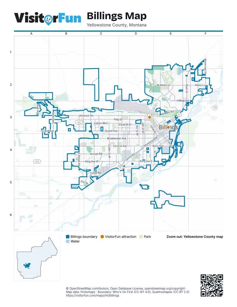
Street index of Billings
Each street on the sheet and the grid squares it crosses.
- Grand AvenueA3, B3, C3, D3, E3
- King Avenue WestB4, C4, D4, D5
- Rimrock RoadA3, B3, C3, D3
- Main StreetE2, F2, E3, C4
- South 24th Street WestC3, C4, C5
- South Shiloh RoadB4, B5
- Montana AvenueE3, D4, E4
- State AvenueD4, E4
- Zimmerman TrailC3, C4
- Airport RoadD3, E3
- Laurel RoadD4
- South 27th StreetE4, C5
- Shiloh RoadB3, B4
- North 27th StreetD3, E3, E4
- 1st Avenue NorthE3, E4
- 4th Avenue NorthE3, E4
- 6th Avenue NorthE3
- 24th Street WestC3, C4
- North 32nd StreetD3, E3, E4
- Zoo DriveB5, C5
- Division StreetE3, E4
- Roundup RoadF1, F2
- Highway 312F1, F2
- East Airport RoadE3
- US Highway 87 EastE3
- Central AvenueB4, C4, D4
- Broadwater AvenueB4, C4, D4, E4
- King Avenue EastD4, E4
- South Frontage RoadD4, E4, C5, D5
- Lake Elmo DriveE1, E2, E3
- Bench BoulevardF2, E3, F3
- Wicks LaneE2, F2
- Gabel RoadC5
- West Wicks LaneD2, E2
- South 32nd Street WestC4, C5
- Aronson AvenueE2, E3
- 6th Street WestD3, D4
- South Billings BoulevardD4, D5
- Molt RoadA2, A3
- Governors BoulevardE2
- 32nd Street WestC3, C4
- Skyway DriveC2, D2
- Midland RoadD5
- Hilltop RoadE2, F2
- Sugar AvenueE4
- Garden AvenueE4
- North 18th StreetE3
- Underpass AvenueD4
- Parkway LaneD4
- 6th Ave BypassE3
- West Hilltop RoadE2
- Swords LaneE3
- Blue Creek RoadD5
- South 7th Street WestD4
- 12th Avenue SouthE4
- North 36th StreetE4
- Poly DriveB3, C3, D3
- Monad RoadB4, C4, D4
- Lewis AvenueC4, D4, E4
- Parkhill DriveB3, C3, D3
- Avenue DB3, C3, D3
- Colton BoulevardB3, C3, D3
- 17th Street WestD3, D4
- 1st Avenue SouthE3, D4, E4
- 13th Street WestD3, D4
- Bitterroot DriveF1, F2
- Hawthorne LaneF1, F2
- 54th Street WestB3
- 14th Street WestD3, D4
- 15th Street WestD3, D4
- 19th Street WestC3, C4
- Overland AvenueC4, C5
- 8th Street WestD3, D4
- Alkali Creek RoadD2, E2, E3
- South 29th Street WestC4, C5
- North 30th StreetD3, E3, E4
- 38th Street WestB3
- Orchard LaneD4
- 16th Street WestD3, D4
- 4th Avenue SouthE4
- Nutter BoulevardE2
- Jackson StreetE4
- Minnesota AvenueE3, E4
- North 25th StreetE3
- East Alkali Creek RoadE3
- Hallowell LaneD4
- Rehberg LaneC3
- North 29th StreetD3, E3, E4
- Gleneagles BoulevardE2
- Virginia LaneD3
- North 26th StreetE3
- 5th Street WestD3, D4
- Mary StreetF2
- Lake Hills DriveE2
- Babcock BoulevardE2
- 9th Avenue NorthD3, E3
- South 28th StreetE4
- Hesper RoadC5
- Yellowstone River RoadF2
- 6th Avenue SouthE4
- Mullowney LaneD4, D5
- Terminal CircleD3
- Calhoun LaneD4
- Moore LaneD4
- North 19th StreetE3
- South 29th StreetE4
- Grant RoadC4
- Riverside RoadE4
- High Sierra BoulevardD2, E2
- Daniel StreetD4
- Washington StreetE4
- North 28th StreetD3, E3, E4
- North 13th StreetE3
- Pierce ParkwayB5, C5
- 7th Avenue SouthE4
- South 34th StreetE4
- South 20th Street WestC4
- South 48th Street WestB4, B5
- South 19th Street WestC4
- South 25th StreetE3, E4
- North 56th Street WestA3, A4
- Senators BoulevardE2
- Pemberton LaneE2, F2
- Simpson StreetD4
- North 33rd StreetE3, E4
- South 25th Street WestC4, C5
- Grandview BoulevardD3
- Foote StreetD4
- Regal StreetD4
- Milton RoadE2
- Hansen LaneE3
- 62nd Street WestA3
- King AvenueC4
- Custer AvenueC4, D4, E4
- Miles AvenueC4, D4
- Yellowstone AvenueC4, D4, E4
- Howard AvenueC4, D4
- Saint John's AvenueC4, D4
- Burlington AvenueB3, C3, D3, E3, B4, C4, D4
- Avenue CB3, C3, D3
- Terry AvenueC4, D4
- Clark AvenueC4, D4, E4
- Cook AvenueC4, D4
- Avenue EB3, C3, D3
- Wyoming AvenueC4, D4, E4
- Avenue BB3, C3, D3, E3
- Avenue FB3, C3, D3
- Alderson AvenueC3, D3, E3
- Briarwood BoulevardE6
- 2nd Avenue NorthE3, E4
- 3rd Avenue NorthE3, E4
- 12th Street WestD3, D4
- Lynn AvenueC4, D4
- Iron Horse TrailC2
- 7th Street WestD3, D4
- 2nd Avenue SouthE3, D4, E4
- Black Otter TrailD3, E3
- 3rd Avenue SouthD4, E4
- Lampman DriveC4, D4
- Charlene StreetE3, E4
- 10th Street WestD3, D4
- 11th Street WestD3, D4
- Rosebud DriveC4
- Canyon DriveC4
- Greenbriar RoadE2
- 9th Street WestD3, D4
- 3rd Street WestD3, D4
- North 31st StreetD3, E3, E4
- 18th Street WestD3, D4
- Palisades Park DriveB3
- Pine Cove RoadB3
- Laredo PlaceB3
- Rim Top DriveD3, E3
- Matador AvenueD2, E2
- Saint Andrew's DriveE2
- Stillwater DriveB4, C4
- North 24th StreetE3
- 8th Avenue NorthD3, E3
- North 23rd StreetE3
- 21st Street WestC3, C4
- 5th Avenue SouthE4
- Patricia LaneC3
- Barrett RoadF2
- Cherry Creek LoopF2
- South 36th Street WestC4
- 2nd Street WestD3, D4
- Stone StreetD4, E4
- Holiday AvenueD5
- Constitution AvenueE2
- Mountain View BoulevardD3, E3
- 7th Avenue NorthE3
- North 22nd StreetE3
- 10th Avenue NorthD3, E3
- Canyonwoods DriveA2
- 11th Avenue NorthD3, E3
- South Plainview StreetD4
- 25th Street WestC3, C4
- Ironwood DriveA2
- Western Bluffs BoulevardA3
- Constellation TrailE1, E2
- Overlook DriveD3
- Clubhouse WayE2
- Elaine StreetF2
- Shamrock LaneE2, E3
- 4th Street WestD3, D4
- South 44th Street WestB4, B5
- Audubon WayB3
- South 38th Street WestB4
- Murphy AvenueD4, E4
- Siesta AvenueD2, E2
- Phillip StreetD4, E4
- Sierra Granda BoulevardD2, E2
- Janie StreetF2
- Indian TrailE3
- Southgate DriveD4
- Wentworth DriveE2
- Watson Peak RoadE2
- Eldorado DriveC4, D4
- Woody DriveC3
- Columbine DriveF2
- Interlachen DriveE1, E2
- McMasters RoadE5, E6
- Forest Park DriveC3
- Beverly Hill BoulevardC3, D3
- Sam Snead TrailA3
- 1st Street WestD3, D4
- Rangeview DriveB3
- Georgina DriveB4, C4
- South 30th Street WestC4, C5
- O Malley DriveD3
- 22nd Street WestC3, C4
- Maurine StreetF2
- 12th Avenue NorthD3, E3
- Crist DriveF2
- Golden BoulevardC3
- 30th Street WestC3, C4
- 41st Street WestB3
- Moon Valley RoadD3, E3
- Vickery DriveB3, C3
- Westfield DriveB3
- Heritage DriveB4, C4
- Anchor StreetE2, F2
- Montana Sapphire DriveB4
- South 31st StreetE4
- Sharron LaneE2
- Cheryl StreetF2
- Mitchell AvenueD4
- Pueblo DriveC4
- Fantan StreetE2
- South 30th StreetE4
- South 31st Street WestC4, C5
- Caroline StreetF2
- North 15th StreetE3
- Tabriz DriveE2, E3
- Annandale RoadE2
- Hewitt DriveC4
- Ryan AvenueD4, E4
- 28th Street WestC3, C4
- Shiloh Crossing BoulevardB4, B5
- North 17th StreetE3
- Vaughn LaneD4, E4
- South 32nd StreetE4
- Morgan AvenueD4, E4
- Granger Avenue WestB4, C4
- 29th Street WestC3, C4
- Mission WayB3
- Calico AvenueD2, E2
- Lyndale LaneC3
- Golden Acres DriveA3
- 8th Avenue SouthE4
- Cortez AvenueD2, E2
- Henry Chapple StreetB4
- Lloyd Mangrum LaneB3
- Lincoln LaneE3
- 20th Street WestC3, C4
- Silver Creek TrailB3
- Concord DriveC4, D4
- North 16th StreetE3
- Henesta DriveC4
- Autumnwood DriveA2
- Ben Hogan LaneA3
- Lyman AvenueC3
- South 33rd StreetE4
- South 26th StreetE4
- Iris LaneC3, D3
- Crawford DriveD3
- 46th Street WestB3
- Woodcreek LoopA2
- Sahara DriveE2, E3
- Caravan AvenueE3
- Stephens LaneD4
- South 12th Street WestD4
- Topanga AvenueD2
- Rolling Hills DriveE1
- Sioux LaneE2
- Newman LaneD4
- Hillview LaneD4
- Beringer WayB3, B4
- Charles StreetD4
- Frontier DriveD5
Places on the map
- Afflerbaugh Park
- Alkali Creek Elementary
- Amend Park
- Arrowhead School
- Beartooth Elementary School
- Billings Clinic
- Billings Logan International Airport
- Billings Public Library
- Billings Senior High School
- Billings West High School
- Bridle Moon Park
- Cameron Park
- Castle Rock Middle School
- Castle Rock Park
- Centennial Park
- Central Heights Elementary
- Central Park
- Cherry Creek Community Park
- Dehler Park
- DoubleTree Billings
- Folf Course (Frisbee Golf)
- Harvest Park
- Joel's Pond
- Joels Pond
- Josephine Park
- Lake Elmo
- Lake Elmo State Park
- Lake Hills Golf Club
- Lillis Park
- Mountview Cemetery
- Pow Wow Park
- Rimrock Mall
- Rose Park
- Senators Park
- Shiloh's Crossing
- Skyview High School
- Stewart Park
- Swords Park
- Terrace Estates
- Zoo Montana
© OpenStreetMap contributors, Open Database License, openstreetmap.org/copyright · Map data: Protomaps · Boundary: Who's On First (CC-BY 4.0); Quattroshapes (CC BY 2.0)