

Montana map
Yellowstone County map
About 171,583 people live here (Census Bureau, 2024 estimate). The sheet's index lists 300 streets; Montana Avenue, Buffalo Trail Road and Musselshell Trail Road cross the most grid squares. Things to do inside the boundary: Billings, DanWalt Gardens and Pompeys Pillar National Monument.
Open the map (PDF, US Letter)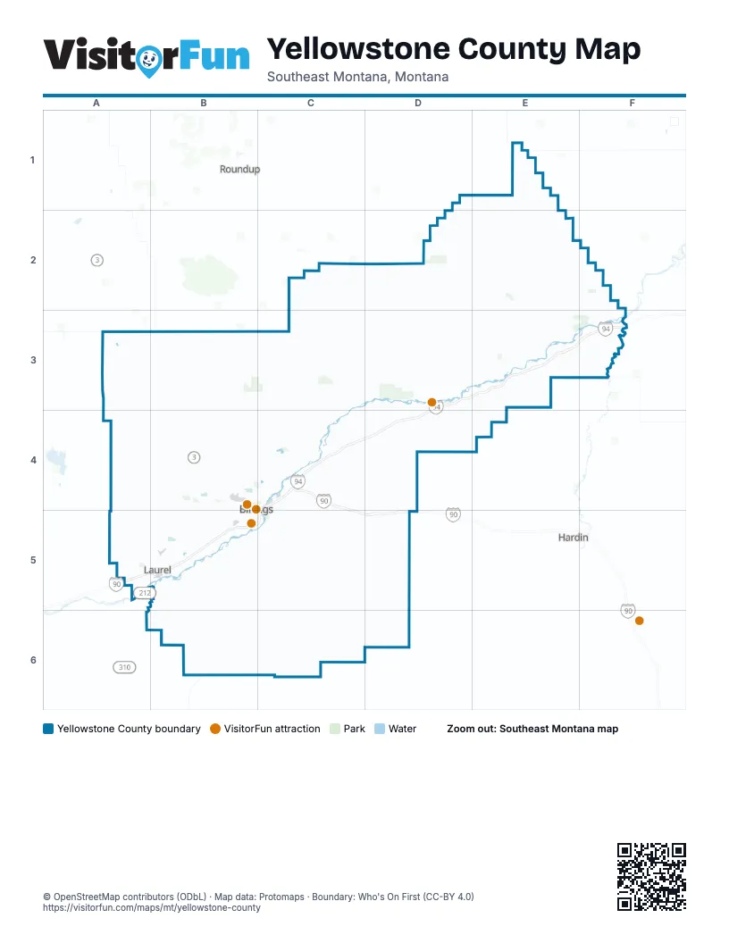
Maps inside Yellowstone County
1 map inside, from the street map of Yellowstone County down.
Street index of Yellowstone County
Each street on the sheet and the grid squares it crosses.
- Highway 312D3, C4, D4
- Roundup RoadC3, C4
- King Avenue WestB5
- US Highway 87 EastC4, C5
- Grand AvenueB5
- Rimrock RoadB4
- Main StreetC4, D4, B5
- South Shiloh RoadB5
- South 72nd Street WestB5
- Montana AvenueA3, B4, C4, B5
- South 24th Street WestB5
- Zimmerman TrailB4, B5
- Shiloh RoadB4, B5
- State AvenueB5, C5
- Airport RoadB4, C4
- Laurel RoadB5
- East Main StreetB5
- South 27th StreetB5, C5
- Northern AvenueC4, D4
- North 27th StreetB4, B5
- 1st Avenue NorthB4, C4, B5
- 4th Avenue NorthB4, C4, B5
- 6th Avenue NorthB4, C4, B5
- 24th Street WestB4, B5
- Zoo DriveB5
- North 32nd StreetB4, B5
- Nahmis AvenueC4
- Division StreetD4, B5
- Iowa AvenueA3
- South 1st AvenueB5
- East Airport RoadC4
- Mossman OverpassB5
- Buffalo Trail RoadA3, A4, A5, B5
- Custer Frontage RoadD3, E3, F3
- Pryor RoadC5, B6, C6
- Molt RoadA4, B4
- Blue Creek RoadB5, C5
- South Frontage RoadB5
- Alkali Creek RoadB4
- Central AvenueB5
- Pryor Creek RoadC4, B6
- Old Hardin RoadC4
- Skyway DriveB4
- Broadwater AvenueB5
- Neibauer RoadB5
- Shorey RoadB4
- Bench BoulevardC4
- King Avenue EastB5
- Old US Highway 10A5, B5
- Lipp RoadA5, B5
- Johnson LaneC4
- Lake Elmo DriveC4
- Wicks LaneC4
- South Billings BoulevardB5
- Gabel RoadB5
- West Wicks LaneB4, C4
- South 32nd Street WestB5
- Aronson AvenueB4, C4
- 6th Street WestB4, B5
- 88th Street WestB4, B5
- 1st AvenueF3, B5
- Clarks River RoadB5
- Garden AvenueB5, C5
- Governors BoulevardB4
- 32nd Street WestB4, B5
- US Highway 312D3
- Midland RoadB5
- Sugar AvenueB5
- Hilltop RoadC4
- South 88th Street WestB5
- North 18th StreetB4
- Laurel North RoadA5, B5
- West Main StreetB5
- Underpass AvenueB5
- Parkway LaneB5
- Swords LaneC4
- 6th Ave BypassC4
- West Hilltop RoadB4, C4
- Laurel Frontage RoadB5
- South 7th Street WestB5
- 12th Avenue SouthB5
- North 36th StreetB5
- Musselshell Trail RoadE1, E2, F2, F3
- Bundy RoadD2, D3
- Shepherd Acton RoadB4, C4
- Hardin RoadC5, D5
- Duck Creek RoadB5, B6
- Indian Creek RoadC4, D4, C5, D5
- Big Horn Valley RoadF3
- Hesper RoadB5
- Fly Creek RoadD3, D4
- Shepherd RoadC3, C4
- Poly DriveB4
- Monad RoadB5
- Yellowstone TrailC4
- South 64th Street WestB5
- Lewis AvenueD4, B5
- Pease Bottom RoadF2, F3
- River RoadB5
- Laurel Airport RoadB5
- Danford RoadB5
- Bitterroot DriveC4
- Colton BoulevardB4
- North Frontage RoadC4
- Coulson RoadC4
- Avenue DB4, B5
- South 56th Street WestB5
- Highway 10F3
- Parkhill DriveB4
- South 48th Street WestB5
- South Laurel RoadB5
- Seitz Ronan RoadB5
- Dover RoadC4
- Yard Office RoadB5
- Hawthorne LaneC4
- Mary StreetC4
- 17th Street WestB4, B5
- Five Mile RoadC4
- 56th Street WestB5
- Thiel RoadB5
- 1st Avenue SouthB5
- South Park City RoadA5
- Elysian RoadB5
- East Maryland LaneB5
- 13th Street WestB4, B5
- Shay RoadA5
- East Railroad StreetB5
- 54th Street WestB4, B5
- Wise LaneB5
- South 16th RoadD4
- Minnesota AvenueA3, C4, B5
- West Railroad StreetA5, B5
- 14th Street WestB4, B5
- Rudio RoadB5
- Shannon RoadB5
- Yellowstone River BridgeC4
- 15th Street WestB4, B5
- Old US Highway 10 EastA5
- 19th Street WestB4, B5
- Pioneer RoadC4
- Orchard LaneB5
- 62nd Street WestB4, B5
- Overland AvenueB5
- 8th Street WestB4, B5
- Story RoadB5
- 2nd AvenueF3, B5
- Yellowstone River RoadC4
- North 56th Street WestB5
- South 29th Street WestB5
- North 30th StreetB4, B5
- Dickie RoadC4
- Ew Tenny RoadC3
- 38th Street WestB4, B5
- 16th Street WestB4, B5
- 4th Avenue SouthB5
- Mullowney LaneB5
- Nutter BoulevardB4, C4
- Jackson StreetB5
- Washington StreetB5
- Becraft LaneC4
- North 25th StreetB4, B5
- West Maryland LaneA5, B5
- Allendale RoadB5
- East Alkali Creek RoadB4, C4
- West 12th StreetA5, B5
- Hallowell LaneB5
- Rehberg LaneB4, B5
- 8th AvenueB5
- Riverside RoadB5
- North 29th StreetB4, B5
- Gleneagles BoulevardB4
- Virginia LaneB4, B5
- 64th Street WestB5
- North 48th Street WestB5
- North 26th StreetB4, B5
- 5th Street WestB5
- Lake Hills DriveB4
- Babcock BoulevardB4, C4
- 9th Avenue NorthB4, B5
- South 28th StreetB5
- Westgate DriveC4
- 6th Avenue SouthB5
- Terminal CircleB4
- Calhoun LaneB5
- Bernhardt RoadB5
- Moore LaneB5
- North 19th StreetB4, B5
- South 29th StreetB5
- Grant RoadB5
- High Sierra BoulevardB4
- South 8th AvenueB5
- Daniel StreetB5
- North 28th StreetB4, B5
- North 13th StreetB4, C4
- Pierce ParkwayB5
- 7th Avenue SouthB5
- South 34th StreetB5
- South 20th Street WestB5
- South 19th Street WestB5
- South 25th StreetB5
- Senators BoulevardB4
- Pemberton LaneC4
- 48th Street WestB5
- Yellowstone RoadC4
- 5th StreetA3, F3, D4
- Grandview BoulevardB4, B5
- Simpson StreetB5
- North 33rd StreetB5
- South 25th Street WestB5
- Foote StreetB5
- Regal StreetB5
- Milton RoadC4
- Carey AvenueC4
- Hansen LaneC4
- Old Highway 10F3
- King AvenueB5
- Goulding Creek RoadB3
- C A RoadC2, D2, C3, C4
- Seven Mile Flat RoadD3, E3
- 21 Mile RoadA3, B3, C3
- Pineview RoadD1, D2, D3
- Frey RoadA3, B3, C4
- Custer Pineview RoadE2, E3
- Lambert Trail RoadC3, D3
- Castle Butte RoadD3
- Oswald RoadB3, B4
- West Arrow Creek RoadD4, D5
- Allen Creek RoadE2, F2, F3
- Hillcrest RoadB5
- Lower Canal RoadD3, C4, D4
- Railroad Creek RoadD2, D3
- Cormier RoadB5, C5, B6
- Squaw Creek RoadC4, D4, D5
- Sando RoadC3
- East Arrow Creek RoadD4
- Spring Creek RoadB5, B6
- Popelka RoadB3, B4
- Keller Welborn RoadE3
- Moser Dome RoadB5, B6
- Alexander RoadB3, B4, C4
- Ballard Ivie RoadA4, B4
- Van Sky RoadB3
- East I RoadD4
- Huffine RoadD2
- Heag RoadB3
- Cottonwood Creek RoadB6
- Stratford Hill RoadB5, B6
- West M RoadC3, D3
- North RoadA3, B3
- Price Hill RoadB5, B6
- Highline Canal RoadD4
- East Pryor Creek RoadC6
- Old Custer RoadF3
- Buffalo Springs RoadB4
- Railroad HighwayC4, D4
- Homer Davis RoadC4
- Scandia RoadC4
- Twelve Mile RoadC3, C4
- Clapper Flat RoadA5
- Scothern RoadD3
- Vandaveer RoadB5
- Bender RoadB3, C5
- Buffalo Creek RoadE3, F3
- Jellison RoadB5
- Birkley RoadB3
- Ridge RoadD3, E3
- Canyon Creek RoadA4, A5, B5
- Reed Creek RoadE3
- Coburn RoadC4, C5
- West Comanche RoadA3, B3
- Metzger RoadB5
- Hibbard Creek RoadD2, D3
- Mainwaring RoadB4
- Rim RoadA3
- Yeoman RoadC4
- Keller RoadB5
- Cemetery RoadA3, B5
- Helfrick RoadC5
- Mailbox RoadC3, C4
- David RoadB3
- West I RoadC4, D4
- Mc Farland RoadA4, B4
- Bermes RoadA4
- Marsh RoadC2, D2
- Clark AvenueD4, B5
- Custer AvenueB5
- Collier RoadB5
- Yellowstone AvenueD4, B5
- Pfister RoadC2, C3
- Schroeder RoadA4
- Burlington AvenueB5
- Wyoming AvenueB5
- Coakley RoadB4
- Red and King Gulch RoadA5
- Moore RoadD2
- North 9th RoadC4
- Miles AvenueB5
- Hofferber RoadC4
- Hoskins Basin RoadB3
- South 80th Street WestB5
Things to do on the Yellowstone County map
Places on the map
- 17 Mile Recreation Area
- Anita Reservoir
- Ballantine
- Billings
- Billings Clinic
- Billings Regional Landfill
- BLM
- Bridle Moon Park
- Broadview
- Broadview Pond
- Coulson Park
- Custer
- Eagle Rock Golf Course
- Four Dances Natural Area
- Huntley
- Huntley Golf Course
- Joel's Pond
- Lake Elmo
- Lake Elmo State Park
- Lake Hills Golf Club
- Lake Josephine
- Laurel
- Laurel Golf Club
- Lockwood
- Montana Audubon Center
- Montana Fair Grounds
- Mountview Cemetery
- MT FWP
- Norm's Island
- OhDeer North Meadow
- Phipps Park
- Rattlesnake Reservoir
- Senators Park
- Shepherd
- Shepherd Ah Nei OHV Area
- State Trust
- Sundance Lodge Recreation Area
- Swords Park
- Terrace Estates
- Underdog
Next to Yellowstone County
- Hardin
- Roundup
© OpenStreetMap contributors, Open Database License, openstreetmap.org/copyright · Map data: Protomaps · Boundary: Who's On First (CC-BY 4.0); Quattroshapes (CC BY 2.0)