

Montana map
Cascade County map
About 84,523 people live here (Census Bureau, 2024 estimate). The sheet's index lists 300 streets; First Special Service Force Memorial Highway, private drive and Old US Highway 91 cross the most grid squares. Things to do inside the boundary: C.M. Russell Museum, Giant Springs State Park and Holiday Village Mall.
Open the map (PDF, US Letter)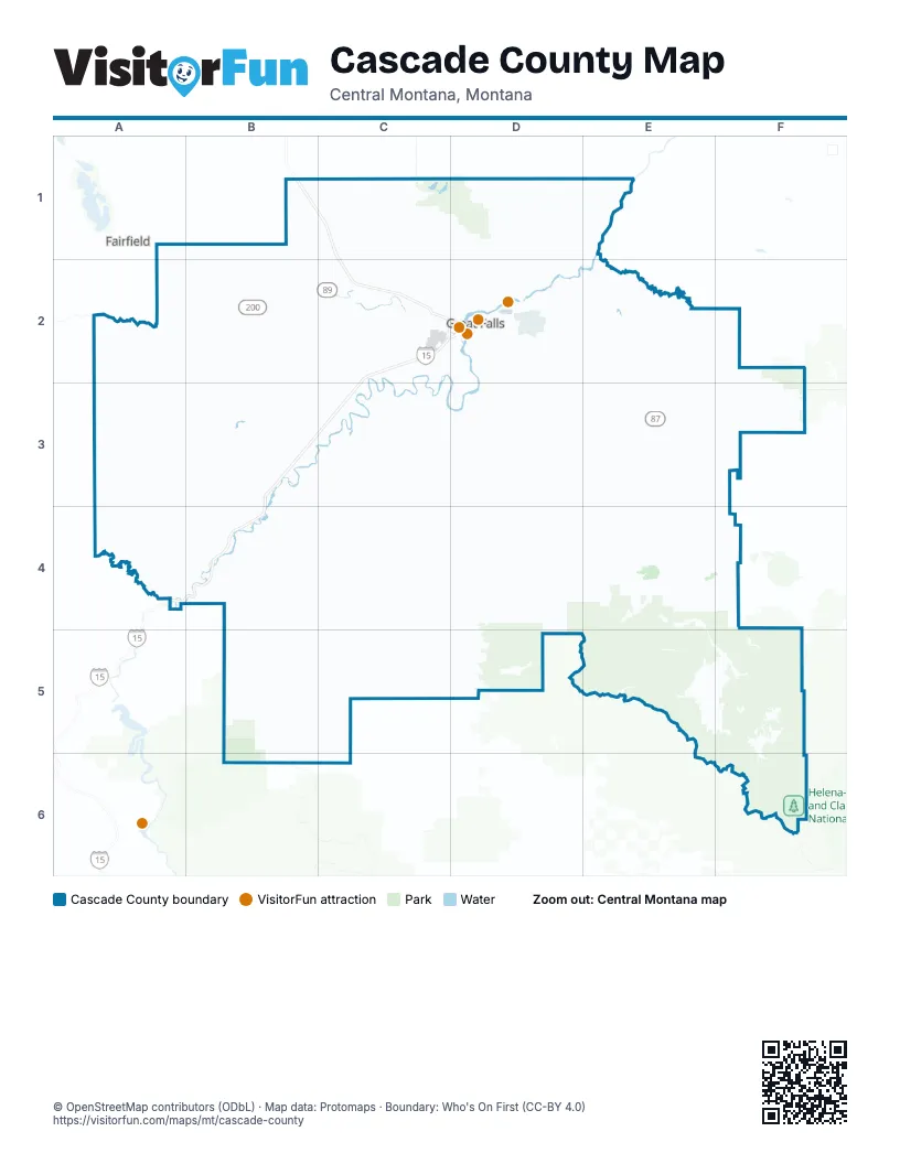
Maps inside Cascade County
1 map inside, from the street map of Cascade County down.
Street index of Cascade County
Each street on the sheet and the grid squares it crosses.
- First Special Service Force Memorial HighwayB1, C1, C2, B3, C3, A4, B4
- Country Club BoulevardD2
- 10th Avenue SouthD2
- 2nd Avenue NorthD2, E3
- River Drive NorthD2
- Central Avenue WestC2, D2, B3
- 1st Avenue NorthD2, B3, E3
- 57th Street SouthD2
- 3rd Street NorthwestD2, B3
- 6th Street SouthwestD2
- Smelter Avenue NortheastD2
- 15th Street NorthD2
- 15th Street SouthD2
- 14th Street SouthD2
- 1st Road SoutheastA1
- 5th Street SouthD2, E3
- 15th Street NortheastD2
- Old Havre HighwayD2
- 6th Street SouthD2
- South Main StreetF5, F6
- 5th Street NorthD2, B3, E3
- 14th Street NorthD2
- Main StreetD3, E3, F5
- Park Drive NorthD2
- 6th Street NorthD2
- North Main StreetA2, F5
- First Avenue North BridgeD2
- Highwood RoadD2, E2
- Belt Creek RoadE2, E3
- Vaughn South Frontage RoadC2
- North Manchester RoadC1, C2
- 6th Street NorthwestD2
- 3rd LaneA2
- Airport DriveC2
- Northwest BypassD2
- Vaughn RoadC2, D2
- Jim Loud Thunder Gopher Memorial HighwayC2, D2
- 9th Street SouthD2
- 9th Street NorthD2
- Watson Coulee RoadC2, D2
- 25th Avenue NortheastD2
- Goddard AvenueD2
- 31st Street SouthwestC2
- 38th Street NorthD2
- Wire Mill RoadD2
- River Drive SouthD2
- 10th Street NortheastD2
- 1st Street NorthwestD2, B3
- Castner StreetE3
- 1st Street SouthwestB3
- 38th Street SouthD2
- Terminal DriveC2
- Overlook DriveD2
- 37th Street NorthD2
- Simms Fairfield RoadA2
- Saint Peter's Mission RoadB3
- Old US Highway 91C2, B3, C3, A4, B4
- Millegan RoadC2, C3, C4
- Eden RoadD2, D3, D4
- Stockett RoadD2, D3
- Cascade Hound Creek RoadB3, B4, C4
- Bootlegger TrailD1, D2
- Ulm Vaughn RoadC2
- Perimeter RoadD2
- Vaughn North Frontage RoadB1, C1
- McIver RoadC2
- Armington RoadE3
- 3rd Avenue SouthD2, E3
- Central AvenueC2, D2, E3
- Fox Farm RoadD2
- 13th Street SouthD2
- Lower River RoadD2
- 2nd Avenue SouthD2, E3
- Giant Springs RoadD2
- North Frontage RoadC1, C2
- Ewing RoadE2, E3
- 13th Avenue SouthD2
- 8th Avenue NorthD2
- Sun River RoadC2, D2
- 10th Avenue NorthD2
- Oriet RoadE4, F4
- Old United States Route 91B4
- 26th Street SouthD2
- 18th Avenue NorthD2
- 14th Street SouthwestD2
- 17th Avenue SouthD2
- Old US 91B4
- 24th Avenue SouthD2
- 23rd Street SouthD2
- 4th Street SouthD2
- 20th Street SouthD2
- North River RoadD2
- 36th Avenue NortheastD2
- 7th Street SouthD2
- 16th Avenue SouthD2
- Skyline Drive NortheastD2
- Huckleberry DriveC2, D2
- Park Garden RoadC2, D2
- 4th Street NortheastD2
- 2nd Street SouthD2
- 9th Street NorthwestD2
- 25th Street SouthD2
- 6th Street NortheastD2
- Division RoadD2
- 52nd Street NorthD2
- 9th Street NortheastD2
- Riverview Drive EastD2
- 2nd Street NortheastD2
- Bald Eagle DriveA4
- 25th Street NorthD2
- Smelter Avenue NorthwestD2
- Flightline DriveD2
- 26th Street NorthD2
- 8th Street NortheastD2
- 72nd Street NorthD2
- Acacia WayC2, D2
- 13th Avenue SouthwestD2
- Goddard DriveD2
- Big Ranch RoadC2
- Lewis StreetC2, E3
- 14th Avenue NorthwestD2
- Park Drive SouthD2
- 2nd Street NorthD2, B3
- 16th Avenue NorthwestD2
- 67th Street NortheastD2
- Sacajawea DriveD2
- Bridge StreetE3
- Market Place DriveC2, D2
- 79th Street NorthD2
- 63rd Street SouthD2
- 1st AvenueC2
- Smelter AvenueD2
- 63rd Street NorthD2
- Central Avenue EastB3
- Craig Frontage RoadA4
- Chicago Milwaukee Saint Paul and Pacific Railroad BridgeD2
- Adel RoadC4, B5, C5
- Evans Riceville RoadD3, D4, E4
- Logging Creek RoadE4, E5
- Birdtail Creek RoadB2, A3, B3, A4
- Willow Creek RoadE2, F2, E3, F3
- Upper Millegan RoadC4, C5, D5
- East Highwood RoadE2, F2, E3
- Benton Lake Wildlife Refuge RoadC1, D1
- Sun River Cascade RoadB2, B3
- Simms-Cascade RoadA2, A3, B3
- Calvert RoadD3, D4
- Divide RoadE5, E6, F6
- Mission RoadA3, B3
- River RoadB3, C3
- Tiger Butte RoadE3, E4
- Wilson RoadC1, D1
- Morony Dam RoadD1, E1, D2, E2
- McCoy RoadD3, E3
- Wilson Butte RoadD2, C3, D3
- Gunderson RoadB1, C1
- Castner Falls RoadB3, C3
- 10 Mile RoadC3, C4
- Spring Creek RoadD3, E3
- Hughesville RoadE4, F4, E5, F5
- Luebbe RoadB2, C2
- Stuckey RoadC1, C2, D2
- 1st Road SouthA1, B1
- West Eden RoadC3, D3
- Sheep Creek RoadB4
- Cottonwood Coulee RoadD3, E3
- Belt Park RoadE5, F5
- Goetz RoadB2, C2
- Anderson RoadB1, C1
- Brigman Coulee RoadF3, E4, F4
- Salem RoadE2
- Powerline RoadD1
- Simms Ashuelot RoadA2, B2
- Neel Creek RoadE3
- Dearborn River RoadA4
- Cora Creek RoadE3, F3
- Black Horse Lake RoadD1
- Fields RoadD2, D3
- Chestnut Valley RoadB4
- Whitmore RoadB4, C4
- Ulm North Frontage RoadC2
- Boston Coulee RoadD3, C4, D4
- Giffen RoadD3
- private driveB1, C1, D1, C2, D2, F3, E4
- Wigand Park RoadB3, B4
- privateB1, C2, C3, D3
- Collins RoadC2
- Old Ulm Cascade RoadB3, C3
- Goon Hill RoadD2, D3
- Vinyard RoadC1, D1, D2
- Red Coulee RoadE2, E3
- Goodwyn Coulee RoadD3
- East Hunter RoadD3
- Upper Sawmill Creek LaneA4
- East Portage RoadD1, E1
- Bickford RoadD2
- Flood RoadC2, D2
- Muddy Creek RoadB2, B3
- Little Belt RoadE3, F3
- Baker RoadC3
- Taft Hill RoadB2, C2
- Ramble Inn RoadB2
- Red Butte LaneD3
- Forest Service Road 3328F6
- Johnson RoadD2, D4
- North Fort Shaw RoadB2
- Dent Bridge RoadD1
- Dracut Hill RoadB1, B2
- West Ulm RoadB2, C2
- Airport Bench RoadC2
- Gruel LaneD1, E1
- Neuman School RoadC1, C2
- 4th Avenue NorthD2, B3
- Prewett Creek LaneA4, B4
- Holmberg RoadE3
- Ashuelot Hill RoadB1, B2
- Schrammeck Lake RoadC3, C4
- Jarvi RoadF3
- 6th Road NortheastB1, C1
- Portage Coulee RoadD1
- Lick Creek RoadE4
- East Eden RoadD4
- 5th Avenue SouthD2
- Forest Service Road 251F6
- Shaw Cutoff RoadB3
- Never Sweat LaneF4
- Gordon RoadB1, C1
- Hevron RoadC1
- North Wilson RoadC1
- Gettle RoadC1
- County Line RoadA1, B1
- McKinior RoadE2
- Harley Creek RoadF5
- Neuman RoadB1
- Old US 89E2, E3
- South Eden RoadD4
- Swift RoadD2, E2
- Old Fort Shaw RoadA2, B2
- Hastings RoadD2, D3
- 9th Avenue SouthD2
- 7th Avenue NorthD2
- 7th Avenue SouthD2
- Enger Cutoff RoadE2
- Fife RoadE2
- South Birdtail RoadB2
- Rickard RoadE2
- Polish RoadC2
- 6th Avenue SouthD2
- Gibson Flats RoadD2
- 3rd Avenue NorthD2, B3
- 1st Avenue SouthC2, D2, B3, E3
- 4th Avenue SouthD2, E3
- Rainbow Dam RoadD2
- Power Line RoadF6
- Orr Coulee RoadE3
- Ross RoadD3
- Mill Coulee RoadB2
- 5th Avenue NorthD2
- Sulphur Springs RoadD1, E1
- Gettel RoadC1
- South Manchester RoadC2
- Tri Hill Frontage RoadC2
- 8th Avenue SouthD2
- Big Bend LaneD2, D3
- 6th Avenue NorthD2
- Black Eagle RoadD2
- Sun Meadows RoadC2
- Prairie Nest RoadE2
- Old Gettle RoadC1
- Adams RoadB2
- Leistiko RoadB2
- Klock RoadC3
- South Manchester LateralC2
- Doctor Russell RoadB2
- Wolfe RoadB4
- Tellinghast RoadE5
- Cascade North Frontage RoadB3
- East Country LaneD1
- Frank RoadD3
- Beckstrom RoadE3, E4
- Chandelle LaneD1, D2
- Paul Creek LaneA4
- Limestone Butte RoadE4, F4
- Dune DriveD2, D3
- Shaw Butte LaneA2
- Fisher RoadD2, D3
- Upper Simms Creek RoadA2
- Fairhaven RoadB3, C3
- Sunflower LaneC2, C3
- Gerber RoadD2
- Missouri River LaneB3, B4
- West Portage RoadD1
- Highwood DriveD2
- Sun Loop LaneC2
- Knapp Creek LaneB3
- Nelson RoadD1
- Bob Gordan LaneE2, E3
- Woodland Estates RoadC2, C3
- Cooper DriveA4, B4
- 15th Avenue SouthD2
Things to do on the Cascade County map
Places on the map
- Anaconda Hills Golf Course
- Belt
- Benefis East
- Benefis West
- Benton Lake
- Benton Lake National Wildlife Refuge
- Black Eagle
- Black Horse Lake
- Cargo Ramp
- Cascade
- Cascade Public Schools
- Charles Russell High School
- Cochrane Reservoir
- Eagle Falls Golf Club
- Elk's Riverside Park
- Fort Shaw
- Gollaher Reservoir
- Great Falls
- Helena-Lewis and Clark National Forest
- Hickory Swing Golf Course
- High Plains Landfill
- Horseshoe Lake
- Malmstrom Air Force Base
- Meadow Lark Country Club
- Montana ExpoPark
- Morony Reservoir
- Neihart
- Park Island
- Rainbow Reservoir
- Ryan Reservoir
- Simms
- Sun Prairie
- Sun River
- Tower Rock State Park
- Ulm
- United Materials
- Vaughn
- Vogl
- Wadsworth Park
- West Bank Park
Next to Cascade County
- Fairfield
© OpenStreetMap contributors, Open Database License, openstreetmap.org/copyright · Map data: Protomaps · Boundary: Who's On First (CC-BY 4.0); Quattroshapes (CC BY 2.0)