

Montana map
Gallatin County map
About 126,984 people live here (Census Bureau, 2024 estimate). The sheet's index lists 300 streets; Access, Gallatin Road and Campground cross the most grid squares. Things to do inside the boundary: American Computer & Robotics Museum, Bozeman Hot Springs and Bridger Bowl Ski Area.
Open the map (PDF, US Letter)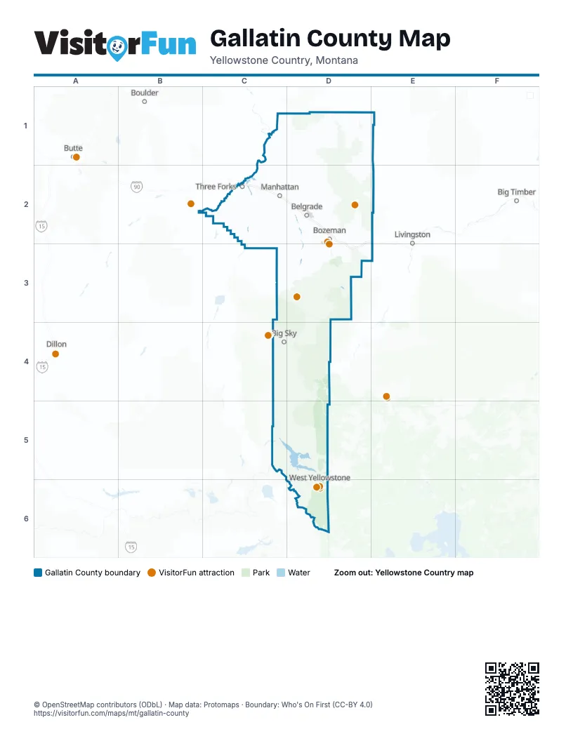
Maps inside Gallatin County
1 map inside, from the street map of Gallatin County down.
Street index of Gallatin County
Each street on the sheet and the grid squares it crosses.
- Gallatin RoadD2, D3, D4, D5, D6
- Frontage RoadC2, D2, D3
- Norris RoadC2, D2, C3
- Churchill RoadC2, D2
- Amsterdam RoadC2, D2
- Springhill RoadD2
- Jackrabbit LaneD2
- Targhee Pass HighwayD6
- South 19th AvenueD2, D3
- East Valley Center RoadD2
- North 19th AvenueD2
- Huffine LaneD2
- West Main StreetC2, D2
- North 7th AvenueD2
- East Main StreetC2, D2
- Montana Highway 2C2
- Yellowstone AvenueC2, D2, D6
- Firehole AvenueD6
- Main StreetC2
- Gallatin StreetC2
- Canyon StreetD6
- Madison StreetC2
- North Main StreetC2
- Broadway Street SouthC2
- Valley Spur RoadD2
- North Canyon StreetD6
- Montana Highway 84C3
- Idaho Medal of Honor HighwayD6
- Bridger Canyon RoadD1, E1, D2
- Dry Creek RoadD1, D2
- Cottonwood RoadC2, D2, D3
- Hebgen Lake RoadC5, D5
- Buffalo Jump RoadC2
- Old Yellowstone TrailC2, D2
- West Dry Creek RoadC2, D2
- Lone Mountain TrailC4, D4
- East Baxter LaneD2
- Durston RoadD2
- West Oak StreetD2
- Bozeman Trail RoadD2, D3
- Airport RoadD2, D6
- Love LaneD2
- South 3rd AvenueD2, D3
- East Cameron Bridge RoadD2
- West College StreetD2
- Davis LaneD2
- West Entrance RoadD6
- Moffit Gulch RoadD2, D3
- West Kagy BoulevardD2, D3
- South Alaska RoadD2
- Highland BoulevardD2, D3
- Spain Bridge RoadD2
- Airway BoulevardD2
- West Graf StreetD3
- East Kagy BoulevardD2, D3
- North Rouse AvenueD2
- South Willson AvenueD2
- Bridger DriveD2
- Cruiser LaneD2
- Kagy BoulevardD3
- East Griffin DriveD2
- West Madison AvenueD2
- East Peach StreetD2
- West Peach StreetD2
- West Griffin DriveD2
- South Main StreetC2
- 5th Street NorthC2
- Broadway Street NorthC2
- East Railroad Avenue NorthC2
- Mandeville DriveD2
- South BroadwayD2
- South 19th RoadD2, D3
- State Highway 86E1
- Flannery BridgeD2
- Hyalite Canyon RoadD3
- Madison Arm RoadD5, D6
- Denny Creek RoadC5, D5, D6
- Thorpe RoadD2
- River RoadD2, D3
- Gooch Hill RoadD2, D3
- Jackson Creek RoadD2
- Blackwood RoadD3
- Stagecoach Trail RoadC2, D2
- Penwell Bridge RoadD2
- Trail Creek RoadD3
- Gateway South RoadD3
- Kelly Canyon RoadD2
- Walker RoadD2
- Rainbow Point RoadD5
- Ousel Falls RoadC4
- Hamilton RoadD2
- Fowler LaneD3
- Nelson RoadD2
- East Baseline RoadD2
- Weaver RoadD2
- Springhill Community RoadD2
- Trident RoadC2
- Heeb RoadD2
- West Babcock StreetD2
- Sourdough RoadD2, D3
- Woodchuck RoadD2, D3, E3
- Stucky RoadD3
- South 3rd RoadD3
- Sypes Canyon RoadD2
- Cameron Bridge RoadC2, D2
- South 11th AvenueD2, D3
- Linney RoadD2
- McIlhattan RoadD2
- Saddle Mountain RoadD2
- Bozeman Hill RoadD2, E2, D3
- Laurel ParkwayD2
- Harper Pucket RoadD2
- North 27th AvenueD2
- Nash RoadD3
- Patterson RoadD3
- Story Mill RoadD2
- Spooner RoadD2
- West Cameron Bridge RoadD2
- Williams Bridge RoadC2
- Tayebeshockup RoadD3
- Deer Creek DriveD2
- Goldenstein LaneD3
- North Ferguson AvenueD2
- Monforton School RoadD2
- Fort Ellis RoadD2, D3
- Bollinger RoadD2
- West Garfield StreetD2
- Tschache LaneD2
- Fallon StreetD2
- Manley RoadD2
- Cobb Hill RoadD2, D3
- Frank RoadD2
- Haggerty LaneD2
- Alaska Frontage RoadD2
- Royal RoadD2
- Collins RoadD2
- South 8th AvenueD2
- Gallatin Field RoadD2
- Cattail StreetD2
- South Church AvenueD2
- Tubb RoadD2
- East Frank RoadD2
- North 15th AvenueD2
- Hidden Valley RoadD2
- Summer Cutoff RoadD2
- Harper Puckett RoadD2
- Madison AvenueC2, D2, D6
- McClellan RoadD5
- West Mendenhall StreetD2
- West Valley Center RoadD2
- South 27th AvenueD3
- Fowler AvenueD2
- L StreetD2
- North 11th AvenueD2
- Stimson LaneD2
- East Northern Pacific AvenueD2
- South Rouse AvenueD2, D3
- Wagon Wheel RoadD3
- Catron StreetD2
- East Oak StreetC2, D2
- North Wallace AvenueD2
- Simmental WayD2
- Catamount StreetD2
- Circle F TrailD2
- East Babcock StreetD2
- East Mendenhall StreetD2
- Concourse LoopD6
- North BroadwayD2
- North Willson AvenueD2
- South Ferguson AvenueD2
- East Tamarack StreetD2
- Chestnut RoadD3
- Tower RoadD2
- North Broadway AvenueD2
- West Tamarack StreetD2
- Mill StreetD3
- Oregon StreetD2
- Iris StreetD6
- Nevada StreetD2
- East Jefferson AvenueD2
- Goldeneye DriveD3
- South Wallace AvenueD2
- West Jefferson AvenueD2
- Dead Mans Gulch CourtD2
- North Grogan StreetD2
- East Cameron AvenueD2
- Cameron Bridge Road WestC2
- East Avocado StreetD2
- Gateway BridgesD3
- Grogan StreetD2
- Kelly Canyon BridgeD2
- Sixteen Mile Creek RoadD1
- Madison RoadC2, C3
- Beaver Creek RoadC4, D4, C5
- Clarkston RoadC1, C2
- Rocky Mountain RoadD1, D2
- Storm Castle RoadD3
- Flathead Pass RoadD1, D2
- Axtell-Anceney RoadC3, D3
- Nixon Gulch RoadC2, D2
- Sixteen Mile RoadC1, D1
- Horseshoe Cottonwood RoadC2, D2
- Francis RoadD1
- Pole Gulch RoadC1, D1
- Line Creek RoadD3
- Kyd RoadC2
- Theisen RoadD2
- Cooper RoadC2
- South Fork RoadD6
- AccessC1, C2, D2, D3, E3, C4, C5, D5, D6
- Camp Creek RoadC2, C3
- Skunk Creek RoadD2
- Skinner RoadD2
- Bench RoadC2
- Fs 1700D6
- Horse Butte RoadD5
- Moose Creek RoadD3
- Bremer Creek RoadD1
- Taylor Fork RoadC4, D4
- FS 74D2
- Seitz RoadD2
- Menard RoadD1, D2
- Petterson RoadD1, D2
- Tepee Creek RoadD5
- Highline RoadD2
- Cougar Creek RoadD5
- Logan Trident RoadC2
- Fs 167C5, D5
- Vincent RoadC2
- FS 980D3
- Brackett Creek RoadD2, E2
- South Plateau RoadD6
- Foster Creek RoadD2
- Nfs Route 1731D5, D6
- Table Mountain RoadC2
- Michener Creek RoadC4, D4
- Big Gulch DriveD2
- Biggs Haugland RoadD2
- Whiskey Springs RoadD6
- Reynolds Creek RoadD2
- Wooden Shoe RoadC2
- Grainbelt RoadC2
- Broken Creek RoadC1
- Bear Creek RoadD2
- Baseline RoadC2
- Ousel Falls View RoadC4
- Charlie Russell LoopC4
- Madison Rim RoadD5
- Crystal Mountain RoadC1
- Spanish Creek RoadC3, D3
- Horseshoe Gulch RoadC2
- Beartrap RoadC2, C3
- Cox RoadD2
- Schutter RoadC2
- Nfs Route 987D6
- Swamp RoadD2
- Reese Creek RoadD2
- Gravel Pit RoadC2
- Olson Creek RoadD2
- Kuipers RoadC2
- Arnold RoadC2
- Round Pole DriveC1, D1
- Prairie RoadC2
- Climbing Arrow RoadC2
- Burnt RoadD2
- Pass Creek RoadD1, D2
- Portnell RoadD3
- Fs 6699D5, D6
- Stone Creek RoadD2
- Gee Norman RoadD2
- Bear Canyon RoadD3
- Montana Ranch TrailD3
- Sappington RoadB2, C2
- CampgroundD3, D4, D5, D6
- Sales RoadD2
- Bear Claw LaneD3
- Johnson RoadD3
- MRL Service RoadC2
- Spaulding Bridge RoadD2
- National Forest Development Road 134C4
- Forswall RoadD2
- Kleinschmidt RoadD3
- Riverview LaneD4
- Ponderosa RoadC1
- Star Ridge RoadD3
- Reservoir Cutoff RoadC2
- Beacon RoadC2
- Beasley Creek RoadD2
- Cottontail RoadD3
- Cache Creek RoadD2
- Wytana RoadC2
- Ridge Fork RoadC4
- Dyk RoadC2
- Twin River Cutoff RoadC2, D2
- Fs 6965D3
- Portal Creek RoadD4
- Buttelman RoadC2
- Annie StreetD2
- Red Canyon RoadD5
- Central Park RoadD2
Things to do on the Gallatin County map
Places on the map
- Amsterdam
- Baxter Creek
- Belgrade
- Big Sky
- Big Sky Golf Course
- Black Bull
- BLM
- Bozeman
- Bozeman Yellowstone International Airport
- Bridger Bowl
- Bridger Creek Golf Course
- Bronken Park
- Burke Park
- Churchill
- Four Corners
- Gallatin County Regional Park
- Gallatin Forks fishing access
- Gallatin National Forest
- Gallatin Wildlife Management Area
- Glen Lake Rotary Park
- Headwaters Public Golf Course
- Hebgen Lake
- Hood Creek Campground
- Horse Butte Peninsula
- Hyalite Reservoir
- Lee Metcalf Wilderness
- Leverich Canyon Trail
- Madison River
- Manhattan
- McLeod Park
- Montana State Land Trust
- MSU Experimental Station
- MT University
- Mystic Lake
- Nelson Meadows
- Public Land
- Reflector Trail
- Spire Rock Campground
- State Trust
- Terminal Apron
Next to Gallatin County
- Big Timber
- Boulder
- Butte
- Dillon
- Livingston
© OpenStreetMap contributors, Open Database License, openstreetmap.org/copyright · Map data: Protomaps · Boundary: Who's On First (CC-BY 4.0); Quattroshapes (CC BY 2.0)