

Montana map
Lake County map
About 33,403 people live here (Census Bureau, 2024 estimate). The sheet's index lists 300 streets; Canal Road, Alexander Lane and Main Street cross the most grid squares. Things to do inside the boundary: Handmade Montana, Polson Chamber of Commerce Visitor Center and Swan Mountain Outfitters.
Open the map (PDF, US Letter)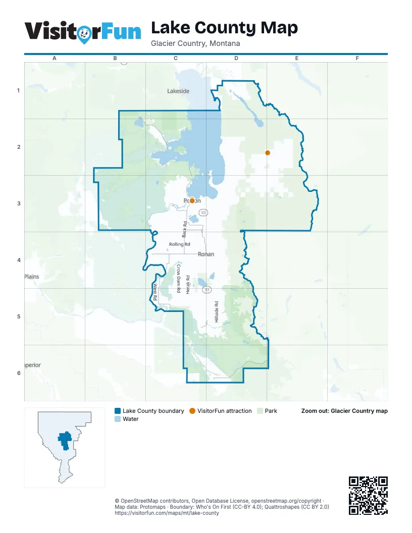
Street index of Lake County
Each street on the sheet and the grid squares it crosses.
- 3rd Avenue EastC3, C4
- 2nd Avenue EastC3, C4
- 2nd Avenue WestC3, C4
- Culloyah StreetD6
- Polson BridgeC3
- Round Butte Road WestC4, D4
- Back RoadC3, C4
- Rocky Point RoadC2, C3
- Kerr Dam RoadC3
- Main StreetC2, C3, C4
- Old Route 93C5
- North Main AvenueD5
- 7th Avenue WestC3
- South Main AvenueC5, D5
- Main Street NorthC4
- Moiese Valley RoadC4, C5
- Lake Mary Ronan RoadB1, B2, C2
- Jocko Canyon RoadD6
- Old US 93C2, C3, C5
- Old US Highway 93C3, C4
- Jocko RoadD6, E6
- Light RoadC3
- Pablo West RoadC3
- A StreetC2
- 7th StreetC2, C3
- 3rd Avenue NorthwestC4
- Cottonwood LaneD6
- Mountain View DriveC5, D5
- Pistol Creek RoadC5, D5, D6
- Irvine Flats RoadB3, C3
- Mission DivideD1, D2
- Saint Mary's Lake RoadC5, D5, D6
- Hillside RoadD4, D5
- Valley View RoadC3, C4
- Boulder Creek RoadD2, D3
- Crow Dam RoadC4, C5
- Yew Creek RoadD1, D2
- South LostD2, E2
- Garcon Gulch RoadB3
- Fatty PiperD3
- Old Squeezer Loop RoadE3
- Burma RoadB2
- B 2000D2
- Old Freight RoadC5
- Napa Point RoadE2
- Foothills RoadD5
- Whitetail RoadD2, D3
- North Foothills DriveD3, D4
- Rolling RoadC4
- Rocky Butte RoadC4
- Leighton RoadC3, C4
- McDonald Lake RoadD4, D5
- West Post Creek RoadC5, D5
- Eli Gap RoadC3
- Watson RoadD5
- Gallagher RoadC4, C5
- Herak RoadC4, C5
- Skyline DriveC3
- Six MileD1, E1, D2
- Buffalo Bridge Road NorthC2, C3
- Logan RoadC4, C5
- Peck Lake RoadD3, E3
- Saddle Mountain RoadC6, D6
- Walking Horse LaneC2, C3
- Dayton Creek RoadC1, C2
- Dublin Gulch RoadC5, D5
- Timberlane RoadD4
- Duck RoadC4, D4
- Airport RoadB3, D5
- Piper Creek RoadD3, E3
- Upper Bug RoadD1
- Twin Lakes RoadD6
- Carbine RoadC4
- North Fork Lost Creek RoadE2
- West Shore RoadB2
- Ninepipe RoadC4, C5
- Canal RoadD3, D4, D5, D6
- Beaver DriveC4
- Eagle Pass TrailD4
- Stinger RoadC4
- North Crow RoadC4, D4
- South Woodward RoadD3
- Robertson RoadC4
- Gildart FlatsD2
- Canyon Mill RoadC4, D4
- Dellwo RoadC4
- Ashley Lake RoadD5
- Mollman Pass TrailD4
- East Post Creek RoadD5
- Hall RoadC4
- Cornelius RoadC4
- Stasso RoadC3, C4
- West RoadC4, C5
- West Swan Shores RoadD1
- Center Loop RoadE2
- Soup-Cilly Cut AcrossE2
- Minesinger TrailC3, D3
- Soup Creek RoadE2
- Forman RoadC3
- Olsen RoadC4, D4
- Goat Creek RoadE2, E3
- Mission Dam RoadD5
- North Reservoir RoadC3
- Repass TrailD5
- Van LakeE3
- Morris RoadC4
- Johnson RoadC3, C4
- Lemery RoadD5
- South Valley Creek RoadC6
- South Finley Point RoadD3
- Loon Lake Ranch RoadC3
- Fatty Creek RoadD3, E3
- Allison RoadD5
- Red Horn RoadD5
- South Ferndale DriveD1
- Falls Creek Alder CreekE3
- Wheatland DriveC5
- North Fork JockoD6, E6
- Goat-Soup Cut AcrossE2
- Grace LaneD4
- Irvine LoopB3
- Ridgeway RoadC4
- Salmon Prairie RoadE3
- Arlee Pines DriveC6, D6
- Dumontier RoadD6
- Mountain View RoadD3
- Meadow RoadC2, C3
- Little Bitterroot RoadB3
- Lower Crossing RoadC5, D5
- Fish Hatchery RoadC4, C5
- Terrace Lake RoadD4
- Apple RoadC3
- Mud Lake TrailC3, D3
- Little Marten RoadC4, D4
- Tower RoadC3
- Spring Creek RoadC4, D4
- Courville TrailC3, D3
- Hawkins RoadC5, D5
- Goat Creek CanyonE2
- Green Mountain RoadB3
- Turnquist RoadC4
- Roullier RoadD4
- White Swan RoadC2
- North Finley Point RoadD3
- Shay Lake RoadD3
- Caffrey RoadC3
- Schoolhouse LaneC5
- McLeod RoadD6
- Porcupine Creek RoadD2
- Clairmont RoadC3, D3
- Valley Creek 1200C6
- Marion LaneB3
- Kings Point RoadC2, C3
- Sloan RoadC4
- Main Woodward RoadD2, D3
- Songer RoadC4
- Sunburst DriveD1
- East Matterhorn RoadC2
- Pickett RoadB3, C3
- Curlew DriveC5
- Baxter RoadB3
- Rollins Lake Shore DriveC2
- Big Meadows RoadC2
- Mission Creek RoadD5
- Summit RoadC5
- Rainbow DriveD1
- Melita Island RoadC2
- Gillette LaneC4
- Seifert RoadC3
- Mink LaneC4
- North Valley Creek RoadC6
- Bug Creek RoadD1
- South Couture LoopD6
- Pinsoneault RoadC5, D5
- Bouchard RoadC4, D4
- Upper Lion CreekE3
- Sylvan DriveD1
- Haegg LaneC4
- Kopp RoadB3
- Roberts RoadC5
- River Breaks LaneC3
- Jette Lake TrailC3
- Baptiste RoadC4
- Cold Creek LaneD5
- Marsh Creek RoadD4, D5
- Dubay RoadD3
- Turtle Lake RoadD3
- Camas RoadC3
- Theresa Adams LaneD6
- Leon RoadC5, D5
- Farm RoadD3
- Radio LaneC3
- Kerns RoadC4, C5
- Kaiser RoadC4
- Corrigan RoadC4
- Piedalue RoadC4
- Buffalo Bridge RoadC3
- Big Lodge RoadC2
- Sederstrom RoadB3
- Haack RoadD3
- Black Point RoadC2
- North Couture LoopD6
- Sabine RoadC5
- Bay Point RoadC3
- Burton RoadB3, C3
- Howlett RoadC4
- Flathead View DriveC3
- 1st Street EastC3, C4
- Charolais RoadC3
- Red Owl TrailD1
- Michel RoadD4
- Peace RoadC3
- Finley Point LaneD2, D3
- Hog Heaven Cattle County RoadC2
- Dixon LaneC3, D3
- Wild Horse Ranch RoadC2
- Esterby LaneC4, C5
- Fenby LaneD2, E2
- Cilly CreekD2, E2
- Prairie DriveC5
- Turtle Lake LoopD3
- Gunbarrel LaneC2
- Hunt LaneC3
- Agency RoadD6
- Crane Mountain RoadD1
- Broken Leg RoadD1
- Addy LaneD3, D4
- River Breaks RoadC3
- Martz DriveD6
- Haystack Mountain LaneD3
- Emory RoadD4
- Bird Farm RoadC5
- Horte LaneC4
- Lost Quartz RoadC2
- 2nd StreetC2
- Mission Lookout RoadD2
- Fox LaneC3
- Condon LoopE3
- Bayview DriveC3
- Plant LaneC6
- La Bella LaneC2
- Pioneer LaneC5
- Pow Wow RoadD6
- Detwiler RoadC6
- Zelezny RoadC2
- Proctor School RoadC2
- Meadowlark LaneC2
- 4th Avenue EastC3, C4
- Cheff LaneD4
- Chalwain RoadD5
- South Fork RoadD6, E6
- Black Lake RoadC2
- Ranch RoadC3
- Bower LaneC2
- White Coyote RoadC6, D6
- D StreetC2, C3
- Rose LaneC3
- Early Dawn DriveC2
- Hughes RoadC4
- Osprey Loop RoadC2
- Loon Lake RoadD1
- Palmer RoadB3, C3
- Hi Frances RoadD6
- Kelley DriveD1
- Lake to Sky DriveD2
- Alexander LaneC2, C3, C4, C5
- Mabbutt Ranch RoadC1
- 2nd Street WestC3, C4
- Finley Point RoadD3
- Jumping Horse LaneC3
- Hawk DriveC3
- Lion Creek SpurE3
- Lion FoothillE3
- Cty RoadC6
- Hellroaring RoadD3
- Popeye TrailC5
- Lost Creek LaneD4
- Coombs LaneD6
- Ponderilla DriveC3
- Falls Creek Alder Creek RoadE3
- Ninepipe LaneC4
- 5th Avenue EastC3, C4
- Squeque LaneC6
- Brooke LaneD4
- Stipe LaneC4
- River Terrace RoadC3
- Wapiti LaneD1
- Camp Aqua RoadB3
- Hillcrest DriveC3
- Price LaneD6
- P3000D6
- South Rim DriveC3
- Dog CreekE3
- Upper Dayton Creek RoadB1, C1
- Park Circle DriveC3
- Munter RoadD2
- Two Creek LaneD4
- Black Wolf TrailD1
- Gunlock RoadD4
- Montana LandingC3, C4
Things to do on the Lake County map
Places on the map
- Arlee
- Ashley Lakes
- Big Arm
- Black Lake
- Bull Island
- Cedar Lake
- Charlo
- Cliff Lake
- Crow Creek Lakes
- Dayton
- Disappointment Lake
- Elmo
- Finley Point
- First Lake
- Flathead Indian Reservation
- Flathead Lake
- Flathead Lake Islands Wildlife Habitat Protection Area
- Flathead Lake State Park
- Grants Meadow
- Horseshoe Lake
- Horte Reservoir
- Jette
- Kerr
- Kicking Horse
- Kickinghorse Reservoir
- Kings Point
- Lake Mary Ronan
- Lake Mary Ronan State Park
- Loon Lake
- Lower Crow Reservoir
- McDonald Lake
- Mission Mountain Golf Club
- Mission Mountains Tribal Wilderness
- Mission Reservoir
- Ninepipe Reservoir
- Ninepipe Wildlife Management Area
- North Swan Valley Wildlife Management Area
- Pablo
- Pablo Wildlife Management Area
- Wild Horse Island State Park
Next to Lake County
- Lakeside
- Plains
- Superior
© OpenStreetMap contributors, Open Database License, openstreetmap.org/copyright · Map data: Protomaps · Boundary: Who's On First (CC-BY 4.0); Quattroshapes (CC BY 2.0)















