

North Carolina map
Carteret County map
About 70,259 people live here (Census Bureau, 2024 estimate). The sheet's index lists 300 streets; Bogue Sound Drive, Shore Drive and Park Avenue cross the most grid squares. Things to do inside the boundary: Cape Lookout National Seashore, Fort Macon State Park and North Carolina Maritime Museum.
Open the map (PDF, US Letter)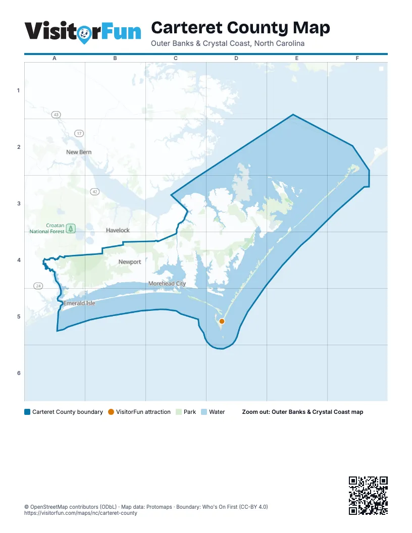
Street index of Carteret County
Each street on the sheet and the grid squares it crosses.
- Arendell StreetC4, D4
- Emerald DriveA5, B5
- Salter Path RoadC4, B5, C5
- Cedar Island RoadF2
- Chatham StreetC3, C4
- Cedar Point BoulevardA5
- West Fort Macon RoadC4
- WB McLean DriveA4, B4, A5
- Taylor Notion RoadA4
- Gallants Channel BridgeD4
- Atlantic Beach BridgeC4
- Atlantic Beach CausewayC4
- Grayden Paul BridgeD4
- South 23rd StreetC4
- West B McLean DriveC4
- Merrimon RoadD2, D3, D4
- Harkers Island RoadD4, E4
- Roberts RoadB4, C4
- Island RoadD4, E4, E5
- Live Oak StreetD4, E4, B5
- Hibbs RoadB4, C4
- Highway 70 Sea LevelF3
- Laurel RoadD4
- East Chatham StreetC4
- Sea Shore DriveF3
- Cedar StreetC4, D4, B5
- Turner StreetD4
- Country Club RoadC4, D4
- Bridges StreetC4, D4
- Nine Mile RoadB4
- South River RoadD2
- East Fort Macon RoadC4, D4
- Lake RoadB3, B4, D4
- Nine Foot RoadB4, C4
- Old Cedar Island RoadF3
- Marshallberg RoadE4
- Straits RoadE4
- Coast Guard RoadA5
- Pigott RoadE4
- Front StreetD4, E4
- North 20th StreetC4
- Lennoxville RoadD4
- Stella RoadA4
- 4-H RoadD2
- Nelson Neck RoadF3
- North 35th StreetC4
- Shell RoadF3, C4
- Blair Farm ParkwayC4, D4
- McCabe RoadC4
- West Railroad BoulevardC4
- Howard BoulevardC4
- Seashore DriveF3
- North 23rd StreetC4
- 24th StreetC4, B5
- Fort Macon RoadD4
- School DriveF3
- 4th StreetD4, B5
- Adams Creek RoadC3
- Straits Cut-Off RoadE4
- Nelson Bay RoadD3, E3
- Mill Creek RoadC4
- Ocean DriveB4, A5, B5
- Old Church RoadA4
- Old Stanton RoadD3
- Old Winberry RoadC4
- Newport Loop RoadC3, C4
- Sea Gate DriveD3
- Wetherington Landing RoadA4
- Garbacon DriveD2
- Crow Hill RoadD4, E4
- Tuttles Grove RoadD3, D4
- Osprey Point RoadD3
- Sound DriveC4, B5
- Hardesty Loop RoadC3, D3, D4
- Hardesty Farm RoadD4
- Evans StreetC4, D4
- Lola RoadF2, C4
- Star Hill DriveA4, B4
- Cannonsgate DriveB4
- West Firetower RoadA4
- Whitehouse Fork RoadA4
- Masontown RoadB4, C4
- Sandy Point DriveD2
- Oakleaf DriveC4
- Russells Creek RoadD4
- Turnpike RoadD3, D4
- Berrys Creek RoadD2
- Canal DriveF3, D4, B5
- Broad Creek Loop RoadB4
- Tom Mann RoadB4, C4
- Bogue Sound DriveA4, C4, A5, B5
- White Oak Bluff RoadA4
- Woodland DriveA4, C4
- Firetower RoadD4, E4
- Pearson CircleB4
- Old Causeway RoadC4, D4
- Fisher StreetC4, D4
- Bogue Loop RoadB4
- Community RoadC4, E4
- Shore DriveC4, D4, E4, B5
- Bay StreetC4, D4
- Lord Granville DriveC4
- Ann StreetD4
- Pelletier Loop RoadA4
- Orange StreetC4, D4
- Shell Hill RoadF3
- Bayview DriveE4, E5
- Oak Hammock DriveD4
- Little Deep Creek RoadC4
- Country Club LaneD3
- Reed DriveA5, B5
- Holly LaneC4, D4, A5
- Pander Cat RoadD3
- Gillikin RoadD4, E4
- Radio Island RoadD4
- Sam Hatcher RoadB4
- Breezy Point RoadA4, D4
- Cape Lookout DriveD4
- Mandy LaneC4
- Croatan DriveA4, B4
- Old Bridge RoadD3, E3
- Shepard StreetC4, D4
- Pond DriveB4, C4
- Easy StreetC4, B5
- Stacy Loop RoadE3
- Eagle RoadB4, C4
- Vfw RoadA4
- Mayberry Loop RoadC4
- Village DriveD2
- Brandywine BoulevardC4
- Dutch Treat TrailC4
- New Bern StreetC4
- Royal RoadD3
- Star Church RoadE4
- Back RoadE4
- Old Swansboro RoadB4
- Ball Farm RoadC3
- Bell Farm RoadB4
- Holland Point RoadA4
- Church StreetC4
- Oyster RoadC4
- Rams Horn RoadB4
- Tootle RoadB4, C4
- Ocean Ridge DriveC4
- Cedar Creek RoadF3, B4, C4
- Old Airport RoadC4
- Gatsey LaneD3
- Morristown RoadA4
- Old River RoadD4
- Neptune DriveA5
- Corbetts LaneB4
- Oak DriveF3, C4
- Pettiford RoadA4
- Dill's Point RoadD4
- West Beaufort RoadD4
- Pine Lake RoadA4, B4
- Silver Dollar RoadD2, D3
- Taylorwood DriveD4
- Crestwood DriveB4
- Mansfield ParkwayC4
- Taylorwood ParkwayD4
- Dogwood CircleC4, B5
- Cedar LaneC4, A5
- Anita Forte DriveA5
- Norris Landing RoadA4
- South Breeze LaneD4
- Donnie Davis RoadE4
- Gales Creek RoadB4
- White DriveC4
- Chimney Branch RoadB4
- East Forrest DriveC4
- Morse RoadA4
- High School Rd.D4
- Guthrie DriveB4, C4, E4
- George Taylor RoadB4
- Red Barn RoadB4
- Broad StreetD4
- Horseshoe RoadA4, E4
- Josephine LaneD4
- Hatcher DriveC4
- Live Oak RoadB4, B5
- Park AvenueC4, D4, A5, B5
- Blue Heron DriveB4
- Morris Marina RoadF3
- J Bell LaneB4
- Diamond City DriveE4, E5
- Ocean Spray DriveA4, A5
- Airbase RoadF3
- Munden Farm RoadC4
- North Harbor DriveD4, E4
- Fairview DriveD4, B5
- Steep Point RoadD4
- Oscar Hill RoadB4, C4
- Island View DriveB4, D4
- North River Club DriveD4
- Henderson DriveB4
- Professional Park DriveD4
- Independence BoulevardC4
- Danny Garner RoadC3
- Wooded Acres DriveC4
- Bay DriveC4, E4
- Barrington RidgeB4
- Fir Ridge LaneD4, E4
- Big Creek RoadD2
- Plantation RoadC4
- Hedrick BoulevardC4
- Old State Hwy 58A4, A5
- Rolling Wood DriveB4
- River Creek LaneA4
- River DriveC4, D4
- Hadnot Creek RoadA4
- Cyrus Pollard RoadC4
- Friendly RoadC4
- Avery StreetC4, D4
- Yacht Club DriveB4
- Wildwood River Ridge RoadC4
- Crew DriveA5
- White Oak DriveC4
- West Southwinds DriveC4
- Youpon DriveA5
- River Shore LaneA4
- Hunting Bay DriveB4, B5
- Jones StreetA5, B5
- Harbor DriveB4, C4
- 2nd StreetB4, D4, E4, B5
- Lanyard DriveB4
- Goose Creek BoulevardB4
- Lejeune RoadB4, A5
- Bayshore DriveB4, A5, B5
- Arrington RoadD4
- Pine StreetC4, D4
- Stewart DriveE4
- Emeline PlaceC4
- Miller Farm RoadC4
- Salty Shores RoadB4
- Bayberry RoadC4
- Sea Gate BoulevardD3
- Wildwood RoadC4
- Farin Ward RoadA4
- Hill StreetF3, C4, D4, A5
- Lands End RoadC4
- Loblolly DriveC4
- Hidden Bay DriveA4
- East South Winds DriveC4
- Huneysuckle LaneC4
- Mason LaneC4, D4
- Shipwreck LaneA5
- Brookside Court SouthA4
- Business DriveC4
- Cedar Swamp RoadB4
- Cape Lookout RoadE5
- Bay RunB4
- Wayland CourtE4
- River Oaks DriveA4
- Camp Morehead DriveC4
- Pelican Harbor RoadD4
- Howard RoadB4
- Dolphin StreetA5
- Polly Hill RoadE4
- Hunting Club RoadD3
- East DriveC4, D4, E5
- Core Sound Loop RoadF3
- Club Point DriveA4, A5
- Bryan StreetC4, B5
- Cummins Creek RoadD2, D3
- Center StreetB4, D4, E4
- Manatee StreetA5
- Croatan Forest RoadA4, A5
- Woodpecker LaneB5
- Olde Farm RoadC4, D4
- Whitetail RoadC3
- Willis Farm RoadC4
- Charles StreetB4, D4, E5
- Old Gate RoadC4
- Maritime PlaceC5
- West Back Creek RoadD3
- Knollwood DriveC4
- Steel Tank RoadD4
- Hickory Shores DriveB4
- Cedar Point Campground RoadA4, A5
- Oglesby RoadC4, D4
- Sandhills DriveB4
- Mill Point LaneD4, E4
- Pelican DriveB4, C4
- Silver Creek Landing RoadA4
- Channel DriveA5
- Glory RoadD4
- Sleepy Point RoadE4
- West Fire Tower RoadA4
- Clayton DriveC4
- Cumberland StreetB4
- Archers Creek DriveB5
- Shoreline DriveE4, A5
- Roosevelt BoulevardC4
- Tarpon WayD2
- Bur Oaks BoulevardB4
- Bayview BoulevardC4
- Arborvitae DriveC4
- Arthur Farm RoadC4
- Jonaquins Creek RoadD2, D3
Things to do on the Carteret County map
Places on the map
- Atlantic Beach
- Atlantic Field MCOLF Airport
- Beaufort
- Bogue
- Bogue Sound
- BT-11 Piney Island
- Calico Creek Marsh
- Cape Carteret
- Cape Lookout beach camping
- Cape Lookout National Seashore
- Cape Lookout Shoals
- Cedar Island Beach
- Cedar Island National Wildlife Refuge
- Cedar Island National Wildlife Reserve
- Cedar Point
- Emerald Isle
- Fort Macon State Park
- Goose Creek RV Resort
- Great Island Cabins
- Harkers Island
- Harlowe & Clubfoot Creek Canal
- Indian Beach
- King Point Marsh
- Marine Corps Outlying Field (MCOF) Atlantic
- Mill Pond
- Morehead City
- Morehead City Country Club
- Newport
- North River
- Ocracoke Inlet
- Open Grounds Farm
- Peletier
- Pine Knoll Shores
- Pocosin Wilderness
- Portsmouth Village
- Raccoon Island
- Rachel Carson Estuarine Sanctuary
- Shackleford Banks
- Star Hill
- Walkers Millpond
Next to Carteret County
- Havelock
- New Bern
© OpenStreetMap contributors, Open Database License, openstreetmap.org/copyright · Map data: Protomaps · Boundary: Who's On First (CC-BY 4.0)