

North Carolina map
Wilmington map
About 125,284 people live here (Census Bureau, 2024 estimate). The sheet's index lists 300 streets; Market Street, Wrightsville Avenue and Martin Luther King Jr Parkway cross the most grid squares. Things to do inside the boundary: Cameron Art Museum and Cape Fear Museum.
Open the map (PDF, US Letter)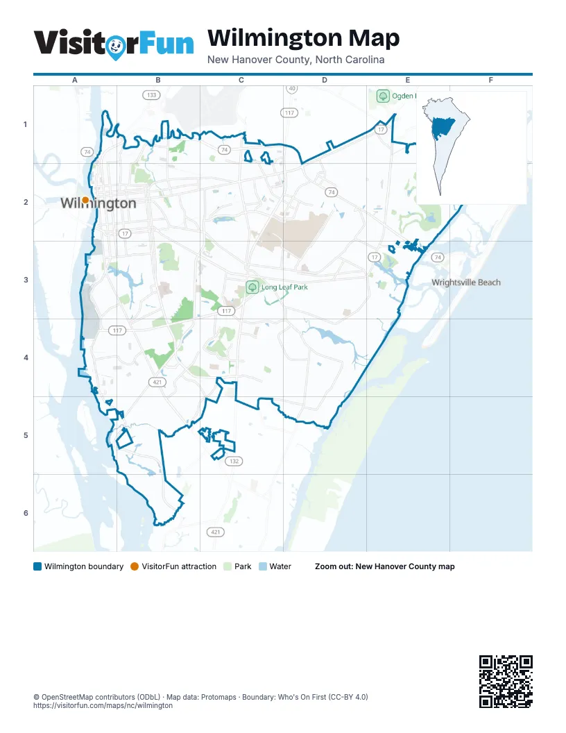
Street index of Wilmington
Each street on the sheet and the grid squares it crosses.
- Martin Luther King Jr ParkwayA1, B1, C1, D1, D2
- Cape Fear Memorial BridgeA2
- Market StreetD1, E1, A2, B2, C2, D2
- South College RoadC2, D2, C3, C4, C5
- South 17th StreetB2, B3, B4, C4
- Wrightsville AvenueB2, C2, D2, C3, D3, E3
- Oleander DriveB2, B3, C3, D3, E3
- Shipyard BoulevardB3, C3, A4, B4
- Carolina Beach RoadA3, B3, B4, B5, C5
- Eastwood RoadD2, E2, E3
- Military Cutoff RoadE1, E2, E3
- South 3rd StreetA2, A3
- South 16th StreetB2, B3
- North College RoadD1, D2
- Burnett BoulevardA3, A4
- Dawson StreetA2, B2
- South Front StreetA2, A3
- North 3rd StreetA1, A2
- Wooster StreetA2, B2
- Gordon RoadE1
- Isabel Holmes BridgeA1
- Independence BoulevardC2, B3, C3, B4, B5
- River RoadA4, A5, B5, B6
- Randall ParkwayC2
- North Front StreetA1, A2
- North 23rd StreetB1, B2
- McRae StreetB1, B2
- Racine DriveD2
- Greenfield StreetA3, B3
- Covil AvenueC2
- Randall DriveC2, D2
- Cornelius Harnette DriveA1, B1
- Castle Hayne RoadB1
- Park AvenueB2, B3, C3, D3
- Arboretum DriveE1, F1, E2, F2
- Greenville Loop RoadD3, E3, D4
- South Kerr AvenueC2, C3
- South 5th AvenueA2, A3, B3
- Robert E Lee DriveC4
- Masonboro Sound RoadD4, D5
- Pine Grove DriveC3, D3, D4
- Chestnut StreetA2, B2
- Princess Place DriveB2, C2
- New Centre DriveC1, C2, D2
- North Kerr AvenueC1, C2
- Masonboro Loop RoadD4, D5
- Pine Valley DriveC3, C4
- Castle StreetA2, B2
- Peachtree AvenueC3, D3
- North 5th AvenueA1, A2
- Forest Hills DriveB2, C2, B3, C3
- Holly Tree RoadC3, C4, D4
- Beasley RoadC4, D4
- George Anderson DriveB4, B5
- Raleigh StreetA4, B4
- Saint Andrews DriveC4, B5, C5
- South 41st StreetC3
- Grace StreetA2, B2
- South 8th StreetB2, B3
- Dock StreetA2, B2
- Rose AvenueD2, D3
- Navaho TrailC5, D5
- South 10th StreetB2, B3
- Chippenham DriveB4, C4, C5
- Riegel RoadC2, C3, D3
- Medical Center DriveB3, B4
- Bragg DriveC4
- Lullwater DriveC2
- College Acres DriveC2, D2
- Wellington AvenueB3, B4
- Rogersville RoadD2
- North 30th StreetB1, B2
- Greenville AvenueD3, E3
- North 11th StreetB2
- North 10th StreetB2
- Gallery Park BoulevardB4
- Colonial DriveB2
- Greenhowe DriveC4
- Oriole DriveD2
- Long Leaf Hills DriveC3
- Burnt Mill DriveC2
- Rankin StreetB2
- Waltmoor RoadC4
- King StreetB1, B2
- Red Cross StreetA2, B2
- Southern BoulevardA3, B3
- One Tree Hill WayB1
- Station RoadE1
- Hinton AvenueD3
- George Trask DriveD2
- Spirea DriveC3
- Wood Dale DriveC3, D3
- Cardinal DriveD1, D2
- Mallard StreetD2
- North 5th StreetA1, A2
- Lennon DriveC1, C2
- Van Campen BoulevardC2
- Nixon StreetA1, B1
- Lansdowne RoadC5
- Vision DriveD2
- Greenway AvenueC2
- North Cardinal DriveD2
- Fairlawn DriveC1
- North 16th StreetB2
- Ringo DriveC1, D1
- North 17th StreetB2
- Doctors CircleB3
- Bob King DriveC2
- Ringo StreetC1, C2
- Portwatch WayA4
- Columb DriveC1
- Collegiate DriveC2
- Judges RoadD1
- South 5th StreetA2
- Covil Farm RoadE1
- Pembroke Jones DriveE2, F2
- East Lake Shore DriveA3, B3
- Trisail TerraceB5, B6
- Appleton WayB5
- South Moorings DriveE2
- South 13th StreetB2, B3
- Town Center DriveE1, D2, E2
- Princess StreetA2, B2
- Ann StreetA2, B2
- Airlie RoadE3
- Long Leaf Acres DriveD2
- South 4th StreetA2, A3
- Sunnyvale DriveA4, B4
- Orange StreetA2, B2
- North 6th StreetA1, A2
- West Lake Shore DriveA3, B3
- Queen StreetA2, B2
- Windemere RoadE1, D2
- Edgerton DriveB5
- South 12th StreetB2, B3
- Tanbridge RoadE1, D2, E2
- Echo Farms BoulevardB4, B5
- Kelly RoadC4, D4
- South 6th StreetA2, B2, B3
- South 7th StreetB2, B3
- Finian DriveD4
- South 15th StreetB2, B3
- South 2nd StreetA2, A3
- Martin StreetA3, B3
- Wilshire BoulevardC2, C3
- Central BoulevardA3, B3
- Adams StreetA3, A4
- Kirby Smith DriveC4
- Gillette DriveB3, C3
- Marstellar StreetA3, B3
- Allens LaneE2, E3
- Church StreetA2, B2
- Nun StreetA2, B2
- South 11th StreetB2, B3
- Wright StreetA2, B2
- Myers StreetA3, A4
- Jeb Stuart DriveB4, C4
- Mears StreetB2, A3, B3
- South Canterbury RoadB3, C3
- Northern BoulevardA3
- Leader CircleB4
- North 4th StreetA1, A2
- North 7th StreetA1, A2, B2
- Freedom Way DriveC3
- Jefferson StreetA3, A4
- Pine StreetA3, C3, D3
- Chalmers DriveC4
- Mercer AvenueC2
- Verrazzano DriveE2
- Amber DriveC4
- South Live Oak ParkwayB3
- Shinnwood RoadD3, E3, E4
- South 14th StreetB2, B3
- Hawthorne RoadB3
- Aster CourtC4, D4
- Stonewall Jackson DriveC3, B4, C4
- South 9th StreetB2, B3
- Watercraft Ferry AvenueA5, B5
- Landfall DriveE2
- Walnut StreetA2, B2
- Deer Island LaneE2
- Towles RoadE3
- Semmes DriveB4, C4
- Monroe StreetA3, A4
- Parkway BoulevardB4
- Birchwood DriveC2
- Merestone DriveB4
- Old Garden RoadD2
- Washington StreetA3, B3
- Clear Run DriveD2
- Wayne DriveB2
- Windchime DriveB5
- Kidder StreetA3, B3
- North Macmillan AvenueC2, C3
- Halifax RoadC3
- Old Military RoadD3, D4, E4
- Country Club RoadB2, B3
- Campbell StreetA2, B2
- Audubon BoulevardC3
- Colony Circle NorthC4, C5
- North 8th StreetA1, B2
- Fairview DriveB4, B5
- Elisha DriveD1, D2
- Shirley RoadB2
- Bonham AvenueC2, C3
- Lake Forest ParkwayB3
- Cavalier DriveE2
- Virginia AvenueA3, B3, A4
- R L Honeycutt DriveB4, C4
- Hooker RoadD2, D3
- Orchard TraceD4
- Walton DriveD2, D3
- Odyssey DriveE2
- Lake AvenueC3
- Hanover StreetA2, B2
- North 2nd StreetA2
- Green Meadows DriveD1, D2
- Barksdale RoadC4, D4, C5
- Worth DriveA4, B4
- Inland Greens DriveD2
- Andover RoadD3
- Fordham RoadB3, C3
- Old Towne StreetB5
- Seahawk Landing DriveD2
- South Churchill DriveB3
- Newkirk AvenueB4
- Northwood DriveE1
- Harnett StreetA2, B2
- Willowick Park DriveD4, D5
- Rutledge DriveA4, B4
- Monument DriveE2
- Eastwinds RoadD2, D3
- Mockingbird LaneC3
- Parker Farm DriveE2
- North 26th StreetB1, B2
- Landmark DriveB4
- Fillmore DriveC2
- Wagoner DriveC2
- Brookshire LaneC4, C5
- Dungannon BoulevardD2
- Canterwood DriveB3
- Mimosa PlaceB2, B3
- Live Oak ParkwayB2, B3
- Harrison StreetA3
- Lincoln RoadC3
- Winston BoulevardC2
- Francis Marion DriveB4
- Moss Tree DriveE2
- Wallington RoadC3, C4
- Shandy LaneE3
- Hawksbill DriveE3
- Upper Reach DriveC4, D4
- John S Mosby DriveC4
- Broomsedge TerraceB5
- Maple AvenueC3
- Barclay Hills DriveC1, C2
- Glen Meade RoadB3
- Spartan RoadD1, E1, E2
- Ocean Point DriveF2
- Pinecliff DriveC4
- Eagles Nest DriveC4, D4
- Bethel RoadC4
- Oak Bluff LaneD3, D4
- South 19th StreetB2
- Ashley CircleC2
- Bradshaw TerraceB5
- Delaney AvenueB3
- Steeplechase RoadB4, B5
- Davie DriveA4, B4
- Plaza DriveB2
- Cedar AvenueC3
- Still Meadow DriveC5
- North Hampton RoadC4, D4
- Cardinal Drive SouthD2
- Bretonshire RoadD2
- Brunswick StreetA2, B2
- Mc Clelland DriveC2
- North 21st StreetB2
- Kenwood AvenueB2
- Longstreet DriveC3, C4
- Kingston RoadD3, D4
- Chalfont CircleD2, E2
- Yorkshire LaneC4, C5
- Hoggard DriveC2
- Sweetbriar RoadC3
- Chester StreetD1, D2
- Partridge RoadC3, C4
- Royal Bonnet DriveE1
- Barclay Pointe BoulevardB4
- Daufuskie DriveB5
- Dapple CourtC2
- Bryan RoadA4, B4
- Whitner DriveC3, C4
- East Blackbeard RoadD4
- Darlington AvenueC2
- Dogwood LaneD3
- Greenville Sound RoadD3, E3
- Wharton AvenueB5
- Hunting Ridge RoadB5
- Wallace Avenue NorthC3
Things to do on the Wilmington map
Places on the map
- Adm Submerged Land
- Airlie Gardens
- Alderman Elementary School
- Anne McCrary Park
- Archie Blue Community Park
- Azalea Post Office
- Calvary Memorial Cemetery
- Cape Fear Country Club Golf Course
- Dogwood Station
- Greene Track & Field Complex
- Greenfield Lake
- Greenfield Park
- Greenlawn Memorial Park Cemetery
- Halyburton Park
- Hoggard High School
- Holly Tree Elementary School
- Independence Mall
- James E. L. Wade Park
- Jungle Rapids
- Landfall Country Club Golf Course
- Long Leaf Park
- Maides Park
- Mayfaire Town Center
- New Centre Market
- New Hanover Regional Medical Center
- Oakdale Cemetery
- Oleander Memorial Gardens
- Pine Valley Country Club
- Pine Valley Elementary School
- Recreational Fields Complex
- Roland-Grise Middle School
- Starway Flea Market
- The Lake at RiverLights
- UNCW Soccer Stadium
- University of North Carolina at Wilmington
- US Post Office - UNC Wilmington
- Virginia Pearson Empie Park
- Wallace Park
Next to Wilmington
- Belville
- Wrightsville Beach
© OpenStreetMap contributors, Open Database License, openstreetmap.org/copyright · Map data: Protomaps · Boundary: Who's On First (CC-BY 4.0)