

North Dakota map
Bismarck map
About 77,772 people live here (Census Bureau, 2024 estimate). The sheet's index lists 300 streets; North 19th Street, North Washington Street and East Main Avenue cross the most grid squares. Things to do inside the boundary: North Dakota Heritage Center & State Museum, North Dakota State Capitol and North Dakota Tourism Division.
Open the map (PDF, US Letter)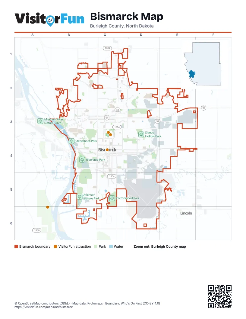
Street index of Bismarck
Each street on the sheet and the grid squares it crosses.
- West Bismarck ExpresswayB4, C4
- State StreetC1, C2, C3
- East Bismarck ExpresswayD3, C4, D4
- North Washington StreetC1, C2, C3, C4
- East Main AvenueC4, D4, E4, F4
- South Washington StreetC4, C5, C6
- East Boulevard AvenueC3, D3
- West Main AvenueB4, C4
- North 7th StreetC3, C4
- North 9th StreetC3, C4
- Memorial HighwayB4, C4
- South 7th StreetC4, C5
- South 9th StreetC4
- West Rosser AvenueC4
- East Century AvenueC3, D3, E3
- 43rd Avenue NortheastC2, D2, E2
- West Century AvenueB3, C3
- University DriveC4, C5, D5, D6
- East 43rd AvenueC2
- River RoadB3, B4
- Tyler ParkwayB1, B2, B3
- Airport RoadD4, C5, D5
- Centennial RoadD2, D3
- West Divide AvenueB3, C3
- Riverside Park RoadB4, C4
- West Arbor AvenueC4
- Washington StreetC3
- 71st Avenue NortheastD1
- Yegen RoadD4, D5, E5, D6
- North 19th StreetC1, D1, D2, D3, D4
- East Calgary AvenueC2, D2, E2
- East Rosser AvenueC4, D4
- East Divide AvenueC3, D3
- East Broadway AvenueC4, D4
- South 12th StreetC4, C5
- North 4th StreetC2, C3, C4
- East Capitol AvenueC3, D3
- Riverwood DriveB4, C4, B5
- 52nd Street NortheastE2, E3, E4
- East Avenue CC4, D4
- South 3rd StreetC4, C5
- North 3rd StreetC3, C4
- North 12th StreetC3, C4
- East Interstate AvenueC3, D3
- East Front AvenueC4, D4
- North 26th StreetD3, D4
- East Miriam AvenueD3, E3
- North 16th StreetC3, C4
- East LaSalle DriveC2, D2
- Ash Coulee DriveB2, C2
- North 5th StreetC3, C4
- South 26th StreetD4, D5
- Airway AvenueD5
- West Turnpike AvenueB3, C3
- Burnt Boat DriveB3
- Edwards AvenueB3
- West Interstate AvenueB3, C3
- 57th Avenue NortheastC1
- East Turnpike AvenueC3
- Country West RoadB3
- North 10th StreetC2, C3, C4
- East Denver AvenueC4
- East Burleigh AvenueC6
- East Indiana AvenueC4, D4
- 57th Avenue NorthwestB1, C1
- Burlington DriveD4, D5
- Apple Creek RoadD4, E4
- Skyline BoulevardC2, D2
- Clydesdale DriveB3
- Dominion StreetC2
- Schafer StreetB3
- West Front AvenueC4
- Fraine Barracks RoadB4
- Lincoln RoadD6
- South 5th StreetC4
- Turnpike AvenueC3
- 52nd Street SoutheastE4
- South 66th StreetF4
- West Denver AvenueC4
- East Thayer AvenueC4, D4
- East Avenue BC4, D4
- East Avenue DC4, D4
- East Avenue EC4, D4
- North 14th StreetC2, C3, C4
- East Bowen AvenueC4, D4
- North 13th StreetC3, C4
- North 11th StreetC2, C3, C4
- Morrison AvenueD5
- Normandy StreetC1, C2
- North 23rd StreetD3, D4
- Clairmont RoadB2, B3
- East Avenue AC4, D4
- North 15th StreetC3, C4
- North 17th StreetD3, D4
- North 2nd StreetC3, C4
- East Sweet AvenueC4, D4
- North 6th StreetC3, C4
- North 20th StreetD3, D4
- Valley DriveB2
- East Valley DriveB2, C2
- North 35th StreetD3, D4
- East Avenue FC4, D4
- North 22nd StreetD3, D4
- North 8th StreetC3, C4
- North 1st StreetC3, C4
- Downing StreetB6, C6
- Industrial DriveD3, D4
- Nebraska DriveD2, D3
- North Mandan StreetC3, C4
- Coleman StreetC2
- Roosevelt DriveE2, E3
- Montreal StreetC2
- Billings DriveC4, C5
- Boulder Ridge RoadC2
- Trenton DriveD3, E3
- Railroad AvenueD4
- North 18th StreetD3, D4
- 17th Avenue NortheastE3, F3
- West Avenue BB4, C4
- West Burleigh AvenueB6, C6
- North 21st StreetD3, D4
- Vermont AvenueD4
- Portland DriveC4, C5
- Santa Fe AvenueC5
- North Griffin StreetC3, C4
- West Medora AvenueB2, C2
- Laforest AvenueC3, D3
- Ward RoadB3, C3, C4
- East Wachter AvenueC5
- Munich DriveC5
- Calypso DriveB6, C6
- Channel DriveD3, D4
- Hamilton StreetD2, D3
- East Central AvenueC3
- Promontory DriveB2, B3
- Frontage RoadD4, D5
- Columbia DriveC4, C5
- West Avenue CB4, C4
- High Creek RoadB2
- North 33rd StreetD3, D4
- Basin AvenueC5, D5
- North Bell StreetC3, C4
- North 31st StreetD3, D4
- Daytona DriveB2, B3
- South 22nd StreetD4, D5
- West Aspen AvenueC2, B3, C3
- Hitchcock DriveE2
- North Anderson StreetC3, C4
- Ottawa StreetC2
- West LaSalle DriveB2, C2
- Cottonwood LoopC5
- Stonewall DriveE2, E3
- Yukon DriveC1, C2
- South 2nd StreetC4
- Saratoga AvenueD2, E2
- Mustang DriveB2, C2
- Overlook DriveC2
- del Rio RoadB2
- Cody DriveB2, C2, B3
- Hackberry StreetC2, C3
- Mills AvenueB5
- South 16th StreetC4, D4
- Shiloh DriveD3
- Pocatello DriveC4, C5
- Powder Ridge DriveB2
- Richmond DriveC4, C5
- Langer LaneB5
- Houston DriveC5
- Juniper DriveC2, B3, C3
- Lee AvenueD4
- London AvenueB5, C5
- Hanaford AvenueC3, D3
- Durango DriveC2
- Michigan AvenueC4, D4
- North Valley LoopD2
- Greensboro DriveD2, E2, E3
- Grant DriveD3
- 66th Street NortheastF3, F4
- Patriot DriveE3
- Porter AvenueC3, D3
- Whisper DriveB5
- South 8th StreetC4
- Knudson AvenueD2
- North 28th StreetD3, D4
- Oakland DriveC5
- Rock Island PlaceD4
- Chisholm TrailB2, B3
- West Sweet AvenueB4, C4
- Gold DriveE2
- South 13th StreetC4
- Northern Plains DriveD5
- Rifle Range DriveD5, E5
- Braman AvenueC3, D3
- Kamrose DriveC5
- Harmon AvenueC3, D3
- Canary AvenueB3
- North 24th StreetD4
- Peach Tree DriveC5
- Lockport StreetC2
- East Arbor AvenueC4
- Slate DriveC2
- Winnipeg DriveC2, C3
- Tacoma AvenueC5
- Arizona DriveD2, D3
- South Reno DriveC5
- Yorktown DriveD3, E3
- West Avenue AB4, C4
- Gateway AvenueC3
- South 18th StreetD4
- Crescent LaneB4, C4
- Manchester StreetC5, C6
- North Hannifin StreetC3, C4
- Chandler LaneD2
- Eagle Crost LoopB2
- North 29th StreetD3, D4
- East Versailles AvenueC2
- Mellowsun DriveB2, C2
- Jackson AvenueD3
- Pointe LoopD2
- Assumption DriveC3
- Franklin AvenueD3
- Dover DriveC5
- Revere DriveD3, E3
- South 11th StreetC4
- Catherine DriveC3
- Thompson StreetC3
- West Buckskin AvenueC2
- Kites LaneB2
- Marian DriveC3
- College DriveB3
- East Colorado DriveD2, D3
- Koch DriveD2
- South 17th StreetD4
- Augsburg AvenueC5
- East Owens AvenueC3
- Marietta DriveC5
- North 27th StreetD3, D4
- North Grandview LaneB3
- Silver BoulevardE2
- Granite DriveC2
- West Bowen AvenueC4
- Voyager PlaceB6
- Boston DriveC5
- West Wachter AvenueC5
- Doubleday DriveE2
- Xavier StreetB3
- Park AvenueD4, C5, D5
- Turnbow LaneE2, E3
- Eastwood StreetC4, C5
- Summit BoulevardB4, C4
- East Brandon DriveC2
- East Highland Acres RoadB3, B4
- Sleepy Hollow LoopD3
- Vision StreetD5
- Kennedy AvenueD3
- Springfield StreetB3, C3
- Lorrain DriveC2
- Rutland DriveC5, C6
- Frost LaneE2
- South Grandview LaneB3
- North 34th StreetD4
- Niagara Drive EastC1, C2
- West Niagara DriveC1, C2
- Omaha DriveC5
- Fountainblue DriveB2, C2
- Domino DriveB3
- Driftwood LaneC2
- South 10th StreetC4
- Brookside LaneC2
- Calvert DriveC1, C2
- North 32nd StreetD4
- Overland RoadB2, C2
- Crested Butte RoadB1
- Canada AvenueC2
- Feldspar DriveC2
- Jefferson AvenueB4, C4
- Telstar DriveC3
- Ontario LaneC3
- Ithica DriveC2, C3
- West Highland Acres RoadB3, B4
- North Parkview DriveB3, C3
- Walter WayC2
- West Capitol AvenueB3, C3
- North 25th StreetD4
- Bozeman DriveC4
- Bremner AvenueC2
- Transport LaneE4
- East Arikara AvenueC3
- Hancock DriveE3
- Continental AvenueC5
- West Owens AvenueB3, C3
- Lake AvenueB4, C4
- Titanium DriveE2
- Lacorte LoopD2
- Ridgeland DriveC1
- Victoria CircleC5
- Macon DriveC5
- Northview LaneD3
- South 15th StreetC4
- Canyon DriveB2, B3
Things to do on the Bismarck map
Places on the map
- Atkinson Nature Park
- Bismarck Conservation and Outdoor Skills Area
- Bismarck High School
- Bismarck Municipal Airport
- Bismarck Rotary Arboretum
- Bismarck State College
- Buckstop Junction
- Capital RV Center of Bismarck
- Capitol Grounds Native Prairie
- Capitol Mall
- Capitol Park
- Cash Wise Bismark Post Office
- Centennial Elementary School
- Centennial Grove
- Century High School
- CHI St. Alexius Health
- Chief Lookings Village
- Cottonwood Park
- Dakota Zoo
- Fairview Cemetery
- Gateway Mall
- Highland Acres Park
- Horizon Middle School
- Keelboat Park
- Kirkwood Mall
- Legacy High School
- Lions Park
- Marian Park
- Missouri Valley Complex
- Pebble Creek Golf Course
- Pioneer Park
- Pioneer Park Trails
- R.J. Bohn Armory
- Riverside Park
- Riverwood Golf Course
- Scheels Complex
- Sleepy Hollow Park
- Southland Park
- Steamboat Park
- Tom O'Leary Golf Course
Next to Bismarck
- Lincoln
© OpenStreetMap contributors, Open Database License, openstreetmap.org/copyright · Map data: Protomaps · Boundary: Who's On First (CC-BY 4.0); U.S. Census Bureau