

North Dakota map
Burleigh County map
About 103,107 people live here (Census Bureau, 2024 estimate). The sheet's index lists 300 streets; State Highway 1804, 171st Street Northeast and 162nd Avenue Northeast cross the most grid squares. Things to do inside the boundary: North Dakota Heritage Center & State Museum, North Dakota State Capitol and North Dakota Tourism Division.
Open the map (PDF, US Letter)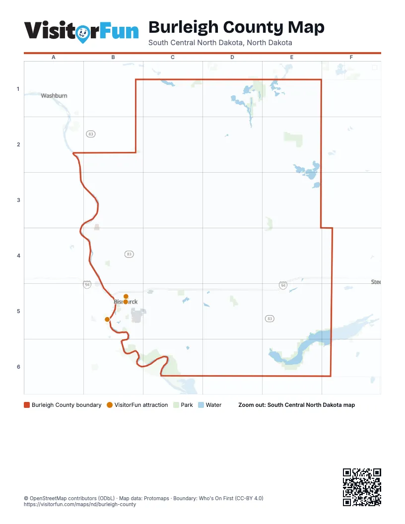
Maps inside Burleigh County
1 map inside, from the street map of Burleigh County down.
Street index of Burleigh County
Each street on the sheet and the grid squares it crosses.
- West Bismarck ExpresswayB5
- State StreetB4, B5
- North Washington StreetB4, B5
- East Bismarck ExpresswayB5
- East Main AvenueB5, C5, D5
- South Washington StreetB5
- East Boulevard AvenueB5
- West Main AvenueB5, D5
- North 7th StreetB5
- North 9th StreetB5
- Memorial HighwayB5
- South 7th StreetB5
- South 9th StreetB5
- West Rosser AvenueB5
- State Highway 1804A2, A3, B3, B4, B5, B6, C6
- State Highway 14E1, E2, E3, E4, E5
- State Highway 36B2, C2, D2, E2
- County Highway 10C5, D5, E5, F5
- 43rd Avenue NortheastB4, C4, D5, E5
- Moffit RoadC6, D6, E6
- 71st Avenue NortheastB4, C4
- State Highway 41B1, C1, B2
- 158th Street SoutheastC5, C6
- East Century AvenueB5, C5
- River RoadB4, B5
- University DriveB5
- Centennial RoadB4, B5
- Tyler ParkwayB4, B5
- West Century AvenueB5
- East 43rd AvenueB4
- Airport RoadB5
- West Divide AvenueB5
- Riverside Park RoadB5
- West Arbor AvenueB5
- Washington StreetB5
- 275th Street NortheastD1, D2, D3, D4, D5
- 392nd Street NortheastE1, E2, E3, E4, E5
- 266th Avenue NortheastB3, C3, D3, E3
- 353rd Street NortheastE1, E2, E3, E4, E5
- 370th Avenue NortheastB2, C2, D2, E2
- 223rd Street NortheastD1, D2, D3, D4, D5
- 184th Street NortheastD1, D2, D3, D4, D5
- 249th Street NortheastD1, D2, D3, D4, D5
- Lincoln RoadB5, C5, D5, E5
- 318th Avenue NortheastB2, C2, D2
- 52nd Street NortheastC1, C2, C3, C4, C5
- 136th Avenue NortheastB4, C4, D4, E4, F4
- 171st Street NortheastD1, D2, D3, D4, C5, D5
- 461st Avenue NortheastC1, D1, E1
- 435th Avenue NortheastB1, C1, D1, E1
- 158th Street NortheastC2, C3, C4, C5
- 201st Avenue NortheastB3, C3, D3, E3
- 26th Street NortheastB2, B3, B4
- 145th Street NortheastC1, C2, C3, C4, C5
- 227th Avenue NortheastB3, C3, D3, E3
- 119th Street NortheastC1, C2, C3, C4, C5
- 106th Street NortheastC1, C2, C3, C4, C5
- 110th Avenue NortheastB4, C4, D4, E4, F4
- 30th Avenue NortheastC5, D5, E5, F5
- 123rd Avenue NortheastB4, C4, D4, E4
- 48th Avenue SoutheastB5, C5, D5, E5
- 97th Avenue NortheastB4, C4, D4, E4, F4
- 102nd Avenue SoutheastB6, C6, D6, E6, F6
- 236th Street SoutheastD5, D6
- 162nd Avenue NortheastB3, C3, D3, E3, E4, F4
- 197th Street NortheastD1, D3
- 357th Avenue NortheastC2, D2, E2
- 405th Street NortheastE1, E3, E4, E5
- 17th Avenue NortheastC5, E5
- 253rd Avenue NortheastB3, C3, E3
- Apple Creek RoadB5, C5
- 214th Avenue NortheastB3, C3, D3, E3
- 80th Street NortheastC1, C2, C3, C4, C5
- 84th Avenue NortheastB4, C4, D4, E4
- 57th Avenue NortheastB4, C4, D4, E4, F4
- 34th Avenue SoutheastE5, F5
- 93rd Street SoutheastC5, C6
- North 80th StreetC4, C5
- 66th Street SoutheastC5, C6
- 366th Street NortheastE1, E2, E3, E4
- 344th Avenue NortheastB2, C2, D2, E2
- Burnt Creek LoopB4
- 236th Street NortheastD1, D5
- 266th Avenue NorthwestB3
- 392nd Street SoutheastE5, E6
- South 12th StreetB5
- North 26th StreetB4, B5
- 89th Avenue SoutheastB6, C6, E6
- Sibley DriveB5, B6
- 175th Avenue NorthwestB3
- Yegen RoadB5
- 471st Avenue NortheastC1, D1, E1
- 340th Street SoutheastE5, E6
- North 19th StreetB4, B5
- 318th Avenue NorthwestB2
- 52nd Street SoutheastC5
- East Calgary AvenueB5, C5
- East Rosser AvenueB5
- East Divide AvenueB5
- East Broadway AvenueB5
- North 4th StreetB5
- East Capitol AvenueB5
- Riverwood DriveB5
- East Avenue CB5
- South 3rd StreetB5
- 80th Street SoutheastC5, C6
- East Burleigh AvenueB5
- 48th Avenue SouthB5, C5
- 385th Street NortheastE2, E3
- North 3rd StreetB5
- North 12th StreetB5
- Ash Coulee DriveB4
- East Interstate AvenueB5
- East Front AvenueB5
- Main StreetE2, E5, E6
- East Miriam AvenueB5, C5
- North 16th StreetB5
- East LaSalle DriveB4
- 57th Avenue NorthwestB4
- North 5th StreetB5
- South 26th StreetB5
- Airway AvenueB5
- Washington Street NorthB4
- West Turnpike AvenueB5
- Main Street SouthC2
- Burnt Boat DriveB5
- Edwards AvenueB5
- West Interstate AvenueB5
- East Turnpike AvenueB5
- Country West RoadB5
- North 10th StreetB5
- East Denver AvenueB5
- East Indiana AvenueB5
- Burlington DriveB5
- Skyline BoulevardB4
- Clydesdale DriveB5
- South 66th StreetC5
- Burleigh RoadB2
- Dominion StreetB5
- Schafer StreetB5
- West Front AvenueB5
- Fraine Barracks RoadB5
- South 80th StreetC5
- 50th Street SoutheastF6
- South 5th StreetB5
- Burleigh AvenueB2
- 45 Street SoutheastF5
- Turnpike AvenueB5
- 4th Avenue SouthwestE5
- Burleigh DriveB2
- County Highway 24B2
- West Denver AvenueB5
- 93rd Street NortheastC1, C2, C3, C4, C5
- 41st Street NortheastB1, B2, B3, B4
- 66th Street NortheastC1, C2, C3, C4, C5
- 418th Street NortheastE1, F1, E2, E3, E4, E5
- 62nd Avenue SoutheastC5, D5, E5
- 132nd Street NortheastC1, C2, C3, C4
- 409th Avenue NortheastB1, C1, D1, E1
- 141st Avenue SoutheastC6, D6, E6, F6
- 188th Avenue NortheastB3, D3, E3
- 15th Street NorthwestB2, B3, B4
- 22nd Avenue SoutheastC5, D5, E5
- 331st Avenue NortheastB2, C2, D2, E2
- 396th Avenue NortheastB1, C1, D1, E1
- 149th Avenue NortheastC4, D4, E4
- 379th Street NortheastE1, E2, E3, E4, E5
- 145th Street SoutheastC5, C6
- 422nd Avenue NortheastD1, E1
- New Johns Lake RoadB1, C1
- 210th Street NortheastD2, D3, D4, D5
- 5th Avenue NortheastC5, D5, E5, F5
- 171st Street SoutheastC5, C6
- 76th Avenue SoutheastC5, C6, D6, E6
- 115th Avenue SoutheastC6, D6, E6
- 240th Avenue NortheastC3, D3, E3
- 223rd Street SoutheastD5, D6
- 340th Street NortheastE1, E2, E3, E4, E5
- 106th Street SoutheastC5, C6
- 383rd Avenue NortheastC2, D2, E2
- 353rd Street SoutheastE5, E6
- 149th Avenue NorthwestA4, B4
- 305th Avenue NorthwestB2
- 54th Street NorthwestB2, B3, B4
- 154th Avenue SoutheastC6, D6, E6
- 262nd Street NortheastD1, D2, D3, D4
- 12th Street NortheastB2, B3, B4
- 275th Street SoutheastD5
- 175th Avenue NortheastB3, D3, E3
- 262nd Street SoutheastD5, D6
- 444th Street NortheastF4, F5
- 279th Avenue NorthwestB2
- 279th Avenue NortheastB2, C2, D2
- 301st Street NortheastE2, E3, E5
- 119th Street SoutheastC5, C6
- 28th Street NorthwestB3, B4
- 249th Street SoutheastD6
- 10th Avenue SoutheastC5, D5, E5
- 110th Avenue NorthwestB4
- 41st Street NorthwestB2, B3, B4
- 197th Street SoutheastD6
- 132nd Street SoutheastC5, C6
- 128th Avenue SoutheastD6, E6
- 201st Avenue NorthwestB3
- Desert RoadB6
- 288th Street NortheastD1, D2, D4, D5
- 327th Street SoutheastE5, E6
- 292nd Avenue NortheastB2, C2, E2
- Island RoadB4
- 156th Avenue NorthwestB4
- East Thayer AvenueB5
- 34th Street NorthwestB4
- Copper Ridge LaneC5
- Ridgeland DriveB4
- East Avenue BB5
- East Avenue DB5
- 240th Avenue NorthwestB3
- East Avenue EB5
- North 66th StreetC4, C5
- North 14th StreetB5
- Apple Creek DriveB5
- 210th Street SoutheastD6
- 431st Street NortheastF4, F5
- East Bowen AvenueB5
- 184th Street SoutheastD5, D6
- North 13th StreetB5
- Clairmont RoadB4, B5
- North 11th StreetB5
- Fernwood DriveB4, B5
- Morrison AvenueB5
- Crested Butte RoadB4
- Normandy StreetB4, B5
- North 23rd StreetB5
- Valley DriveB5
- Moonstone LaneB4
- 301st Street SoutheastE5, E6
- East Avenue AB5
- 405th Street SoutheastE5, E6
- 379th Street SoutheastE5, E6
- 292nd Avenue NorthwestA2, B2
- North 15th StreetB5
- Downing StreetB5
- 48th Avenue SouthwestB5
- North 17th StreetB5
- North 2nd StreetB5
- Hogue RoadB4
- 136th Avenue NorthwestB4
- 67th Street NorthwestB2, B4
- Shoal DriveC4
- 80th Street NorthwestB2, A3, B3, B4
- East Sweet AvenueB5
- North 6th StreetB5
- Railroad AvenueE2, B5
- North 20th StreetB5
- East Valley DriveB4, B5
- Sonora WayB4
- North 35th StreetB5
- East Avenue FB5
- Misty Waters DriveB4
- Northwood DriveB4
- 162nd Avenue NorthwestB3
- North 22nd StreetB5
- North 8th StreetB5
- 28th Avenue SoutheastC5
- Star LaneC4
- Barston LaneC5
- North 1st StreetB5
- England StreetB5
- Industrial DriveB5
- 366th Street SoutheastE5, E6
- Parker Ranch RoadB4
- Dolan DriveC5
- Nebraska DriveB4, B5
- North Mandan StreetB5
- Coleman StreetB4, B5
- Silver BoulevardC4, C5
- Roosevelt DriveC4, C5
- Montreal StreetB4, B5
- Billings DriveB5
- Boulder Ridge RoadB4, B5
- Trenton DriveB5, C5
- West Burleigh AvenueB5
- 73rd Avenue NortheastB4
- Glenwood DriveB5
- Derek DriveC5
- North 18th StreetB5
- Runnel RoadC4
- Boston DriveB5
- Woodrow DriveC5
- 74th Street NorthwestB2
- Horseshoe BendB4
- 418th Street SoutheastE6
- 33rd Street NortheastB3
- 86th Street NortheastC3
- 191st Street NortheastD5
- 156th Avenue NortheastC4
- Northgate DriveC5
- South Fork JunctionB6
- Sandy River DriveB4
- West Avenue BB5
Things to do on the Burleigh County map
Places on the map
- Apple Creek Country Club
- Arena Wildlife Management Area
- Atkinson Nature Park
- Bernhardt WPA
- Bismarck
- Bunce lake
- Bunker lake
- Capital City Sporting Clays
- Cottenwood Lake
- Cottonwood Park
- Crimmins WPA
- Dakota Zoo
- East Sibley Nature Park
- Florence Lake
- Florence Lake National Wildlife Refuge
- Harriet Lake
- Hawktree Golf Club
- Kimball Bottoms Wildlife Management Area
- Lake Oahe
- Lincoln
- Long Lake
- Long Lake National Wildlife Refuge
- MacLean Bottoms Wildlife Management Area
- McDowell Dam Recreation Area
- McKenzie Slough
- Missouri Valley Complex
- New Johns Lake
- O'Brien Lake
- Pebble Creek Golf Course
- Pelican Lake
- Pioneer Park
- Pioneer Park Trails
- RadAcademy Loop
- Rath/Wonnenburg WPA
- Regan
- Rice Lake Wildlife Management Area
- Riverside Park
- Riverwood Golf Course
- Salt Lake
- Sleepy Hollow Park
Next to Burleigh County
- Steele
- Washburn
© OpenStreetMap contributors, Open Database License, openstreetmap.org/copyright · Map data: Protomaps · Boundary: Who's On First (CC-BY 4.0); Quattroshapes (CC BY 2.0)