

North Dakota map
Fargo map
About 136,285 people live here (Census Bureau, 2024 estimate). The sheet's index lists 300 streets; 2nd Street North, 36th Street South and 33rd Street Southwest cross the most grid squares. Things to do inside the boundary: Fargo Air Museum, Fargo Theatre and Plains Art Museum.
Open the map (PDF, US Letter)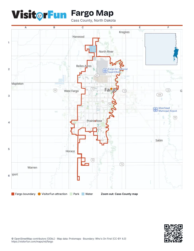
Street index of Fargo
Each street on the sheet and the grid squares it crosses.
- 45th Street SouthC3, C4, C5, C6
- South University DriveD3, D4, D5, D6
- 52nd Avenue SouthB5, C5, D5
- 13th Avenue SouthC3, D3
- 19th Avenue NorthC2, D2, E2
- Main AvenueC3, D3, E3
- 38th Street SouthC3, C4, C5
- North University DriveD1, D2, D3
- 10th Street NorthD1, D2, D3
- 45th Street NorthC2, C3
- 9th Street SouthD3, D4
- 10th Street SouthD3, D4, D5
- 1st Avenue SouthD3
- 25th Street SouthD3, D4, D5, D6
- 12th Avenue NorthC2, D2, E2, D3
- 32nd AvenueC4, D4
- 40th Avenue SouthC5, D5
- 42nd StreetC4, C5
- 7th Avenue NorthC3, D3, E3
- 18th Street SouthD3, D4, D5, D6
- Veterans BoulevardC4, C5
- 17th Avenue SouthC4, D4
- 2nd Street NorthE1, D2, E2, D3, E3
- 40th Avenue NorthC1, D1
- 1st Avenue NorthC3, D3
- 42nd Street SouthC3, C4, C5
- 25th Street NorthD1, D3
- Joe Parmer BoulevardD2
- Dakota DriveD2
- 32nd Avenue SouthwestC4
- 40th Avenue EastB5, C5
- 45th Street NorthwestC2
- 12th Avenue NortheastC2
- 9th Street EastC4
- 52nd Avenue EastB5
- 36th Street SouthC3, C4, C5, D5, C6
- 23rd Avenue SouthC4, D4
- 15th Avenue NorthC2, D2, E2
- BroadwayD1, D2, D3
- 32nd Street SouthD3, D4, D5
- Elm Street NorthE1, E2, E3
- 36th Avenue SouthC4, D4, C5, D5
- 44th Avenue SouthC5, D5
- Old 81C1, C2, D2
- 4th Street NorthD2, D3
- 32nd Avenue NorthC2, D2, E2
- 32nd Avenue EastC4
- 18th Avenue SouthC4, D4
- 64th Avenue SouthC6, D6
- 40th Street SouthC3, C4, C5
- 2nd Avenue SouthC3, D3
- 34th Street SouthC3, C4, C5
- 5th Street SouthD3, D4
- 8th Avenue NorthD3, E3
- 5th Avenue SouthD3
- 76th Avenue SouthC6, D6
- 18th Street NorthD2, D3
- 25th Avenue SouthD4
- 19th Avenue SouthC4, D4
- 4th Avenue NorthD3
- 24th Avenue SouthC4, D4
- Northern Pacific AvenueD3, E3
- 70th Avenue SouthD6
- 26th Avenue SouthC4, D4
- 47th Street SouthC4, C5
- 53 Avenue SouthC5
- 4th Street SouthD3, D4
- 9th Avenue SouthwestC3
- 27th Avenue SouthD4
- 25th Avenue NorthD2, E2
- 29th Street NorthD2, D3
- Westrac DriveC3, D3
- Brandt Drive SouthC4
- Dakota Drive NorthD2, D3
- 52nd Street SouthwestC3, C4
- Deer Creek Parkway SouthB5
- 63rd Street SouthB5
- 17th Avenue SouthwestC4
- Fiechtner DriveD3
- 35th Street NorthC2, C3
- Fiechtner Drive SouthC3, D3
- 2nd Street SouthD3, E3
- 7th Avenue EastC3
- 17th Street EastC3
- 17th Avenue EastC4
- 4th Street EastB5
- 40th Avenue SouthwestD5
- 9th Street NortheastC2
- 36th Avenue EastC4
- 15th Street SouthD3, D4, D5, D6
- 14th Street SouthD3, D4, D5, D6
- 17th Street SouthD3, D4, D5, D6
- 30th Avenue SouthC4, D4
- 21st Street SouthD3, D4, D5, D6
- 3rd Street NorthD2, D3
- 15th Avenue SouthC3, D3, C4, D4
- 11th Street SouthD3, D4, D5
- 23rd Street SouthD3, D4, D6
- 37th Avenue SouthC5, D5
- 3rd Avenue NorthC3, D3
- 28th Avenue SouthC4, D4
- 16th Street SouthD3, D4, D5, D6
- 8th Street NorthD2, D3
- 28th Street SouthD3, D4, D5, D6
- 22nd Street SouthD3, D4, D5, D6
- 7th Street NorthD2, D3
- 37th Street NorthC1
- 20th Street SouthD3, D4, D5, D6
- 43rd Street NorthC2, C3
- Prairiewood DriveC4, D4
- 9th Avenue SouthC3, D3
- 9th Street NorthD2, D3
- 38th Avenue SouthC5, D5
- 11th Avenue NorthD3, E3
- 16th Avenue SouthC3, C4, D4
- 12th Street NorthD2, D3
- 33rd Avenue SouthC4, D4
- 47th Avenue SouthC5, D5
- 57th Street SouthC6
- 34th Avenue SouthC4, D4
- 51st Street SouthC3, C4, C5
- 4th Avenue SouthC3, D3
- 14th Avenue SouthC3, D3
- 27th Street SouthD3, D4, D6
- 1st Street NorthE1, E2, E3
- 7th Street SouthD3, D4
- 5th Street NorthD2, D3
- 35th Avenue SouthC4, D4
- 11th Street NorthD1, D2, D3
- 10th Avenue NorthD3, E3
- 8th Street SouthD3, D4
- 14th Avenue NorthC2, D2, E2
- 43rd Street SouthC4, C5
- 11th Avenue SouthC3, D3
- 33rd Street SouthwestC3, C4, D4, C5, D5
- 8th Avenue SouthC3, D3
- 52nd Ave NC1
- 12th Avenue SouthD3
- 7th Avenue SouthD3
- 6th Avenue SouthD3
- 17th Avenue NorthD2, E2
- 28th Avenue NorthD2, E2
- 20th Avenue SouthC4, D4
- 19th Street SouthD3, D4, D6
- 49th Avenue SouthB5, C5, D5
- 10th Avenue SouthC3, D3
- 56th Avenue SouthB5, C5, D5
- 16th Avenue NorthC2, D2, E2
- 12th Street SouthD3, D4, D5
- 21st Avenue SouthD4
- 39th Avenue SouthC5, D5
- 3rd Avenue SouthD3
- 39th Street SouthC4, C5
- 58th Avenue SouthB5, C5, D5
- 55th Street SouthC4, C5
- 13th Avenue NorthD2, E2
- 14th Street NorthD2, D3
- 38th Street NorthC2, C3
- 44th Street SouthC3, C5
- 40th Street NorthC2, C3
- 67 Avenue SouthD6
- 54th Street SouthC4, C5
- Albrecht BoulevardD2
- Roger Maris DriveD4, E4
- 6th Street SouthD3, D4
- 9th Avenue NorthD3, E3
- 16th Street NorthD2, D3
- 44th Street SouthwestC3, C4
- 27th Street NorthD2, D3
- 31st Street SouthD3, D4, D5
- 51st Avenue SouthB5, C5
- 54th Avenue SouthB5, C5, D5
- 35th Street SouthC3, C4, C5
- 31st Avenue SouthC4, D4
- 41st Street SouthC3, C4
- Oak Street NorthE2, E3
- Centennial BoulevardD2
- 45th Avenue SouthB5, C5, D5
- San Juan DriveC3
- River DriveD4, D5
- 13 1/2 Street SouthD3, D4
- 66th Street SouthB5
- 33 Avenue SouthC4
- 53rd Street SouthC5
- 5th Avenue NorthD3
- 55th Avenue SouthB5, C5, D5
- 48th Avenue SouthB5, C5, D5
- Rose Creek Parkway EastD5
- 20th Street NorthD1, D3
- 23rd Avenue NorthD2, E2
- 6th Avenue NorthD3, E3
- Lilac LaneE2
- 14 1/2 Street SouthD3, D4
- 62nd Avenue SouthD5, D6
- 30th Avenue NorthD2, E2
- 9 1/2 Street NorthD2
- Amber Valley Parkway SouthC4
- 35th AvenueD4
- 73rd Avenue SouthD6
- 21st Avenue NorthD2, E2
- Harwood DriveD4
- 16 1/2 Street SouthD3, D4
- 26th Avenue SouthwestC4, D4
- 22nd Avenue NorthD2, E2
- Woodhaven Drive SouthC5
- Wheatland DriveC4, D4
- 24th Avenue NorthC2, D2, E2
- 2nd Avenue NorthD3
- 24th Street SouthD3, D6
- West Gateway CircleD3, D4
- 43rd Avenue SouthC5, D5
- 30th Avenue SouthwestC4, D4
- 41st Street NorthC2
- 39 1/2 Avenue SouthC5, D5
- 58th Street SouthB5, C5
- Seter Parkway SouthC4
- Rose Creek Parkway SD5
- 29th Avenue NorthD2, E2
- 39th Street NorthC2, C3
- Golden Valley Parkway SouthD6
- 36th Street NorthC3
- Timberline DriveD5
- 19th Street NorthD2, D3
- 49 Street SouthC4, C5
- Parkview DriveC4, D4
- 46th Avenue SouthC5, D5
- Great Northern DriveD3
- Golf Course RoadE1
- 65th Avenue SouthD6
- Autumn Drive SouthC5, D5
- 26th Street SouthD4, D6
- 33rd Street SouthC3, C4, C5, C6
- 39 1/2 Avenue NorthD1
- Rose Creek DriveD5
- Southgate Drive SouthD3, D4
- 34th Street SouthwestC3, C4, C5
- 59th Avenue SouthB5, D5
- 22nd Avenue SouthC4, D4
- 15th Street NorthD3
- Osgood Parkway SouthB5
- Woodcrest Drive SouthE2
- Page DriveD3
- 32nd Avenue NortheastE2
- 37 1/2 Avenue SouthC5, D5
- 21st StreetD5, D6
- 31st Avenue NorthD2, E2
- 41st Avenue SouthC5, D5
- Maple StreetE2, E3
- 32nd Street NorthD1, D2, D3
- 42nd Avenue SouthC5, D5
- College StreetD2, D3
- Evergreen Road NortheastE1, E2
- 18th Avenue NorthD2, E2
- 35 Avenue SouthC4
- Santa Cruz DriveC3
- 31st Street NorthD1, D3
- Countryside Trailer CourtD3
- 43rd Street SouthwestC3
- Farmstead Court SouthC5
- 38 1/2 Avenue SouthD5
- Forest Avenue NorthD2, E2
- 44th Avenue NorthC1, D1
- Bishops BoulevardD5
- 47 Street SouthC4
- 17th Street NorthD2, D3
- West Country Club DriveD4
- 35th Avenue NortheastE1, E2
- Par Street NortheastE1, E2
- D StreetC3
- 75th Avenue SouthD6
- 13 Circle SouthD5, D6
- 56th Street SouthC4, C5
- 34 1/2 Avenue SouthD4
- 37th Avenue NorthD1
- Hickory StreetE2
- 59th Street SouthB5
- 48th Street SouthwestC3
- 63rd Avenue SouthB5, C6
- 50th Street SouthwestC3, C4
- 33rd St NorthwestC1
- 57th Avenue SouthB5, D5
- Longfellow Road NortheastE1, E2
- Great Plains DriveC5
- 28th Street NorthD2, D3
- 53rd Avenue SouthB5, D5
- Rocking Horse Circle SouthB5
- 29th Street SouthD3, D4
- 10th Avenue SouthwestC3
- Evergreen RoadE2
- Roberts Street NorthD3
- 29th Avenue SouthD4
- 21st Street NorthD3
- Wildflower Drive SouthB5, C5
- Selkirk Dr SouthD5, D6
- Kandi LaneD1, E1
- 26th Street NorthD2, D3
- Willow Road NortheastE2
- 35th Avenue NorthD2, E2
- East Gateway Circle SouthD3, D4
- Sheyenne Loop NorthC2
Things to do on the Fargo map
Places on the map
- Amber Valley
- Anderson Park
- Bennett
- Bluemont Lakes
- Brandt Crossing
- Brunsdale
- City of Fargo Landfill
- Clara Barton
- Davies
- Deer Creek
- Downtown
- Downtown Fargo District
- Edgewood Golf Course
- Fargo Air National Guard Base
- Fargo Country Club
- Hawthorne
- Iwen Park
- Jefferson/Carl Ben
- Lewis & Clark
- Lincoln
- Lindenwood Park
- Longfellow
- Madison/Unicorn Park
- Maple Valley
- North Dakota Horse Park
- North Softball Complex
- Northport
- Osgood
- Osgood Golf Course
- Pointe West
- Ponte's Park
- River Drive
- Rose Creek
- Rose Creek Golf Course
- South High
- Southpointe
- Stonebridge
- The District
- Trollwood
- Urban Plains
Next to Fargo
- Moorhead
- North River
- Prairie Rose
- Reiles Acres
- West Fargo
© OpenStreetMap contributors, Open Database License, openstreetmap.org/copyright · Map data: Protomaps · Boundary: Who's On First (CC-BY 4.0); U.S. Census Bureau