

North Dakota map
Cass County map
About 200,945 people live here (Census Bureau, 2024 estimate). The sheet's index lists 300 streets; 3rd Street, Main Street and 1st Street cross the most grid squares. Things to do inside the boundary: Bonanzaville, USA, Fargo Air Museum and Fargo Theatre.
Open the map (PDF, US Letter)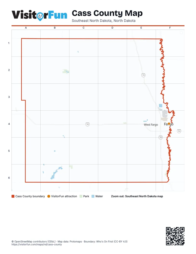
Maps inside Cass County
1 map inside, from the street map of Cass County down.
Street index of Cass County
Each street on the sheet and the grid squares it crosses.
- State Highway 18D1, D2, D3, D4, C5, D5, C6, D6
- State Highway 46A6, B6, C6, D6, E6, F6
- South University DriveF4, F5
- 45th Street SouthF4, F5
- 38th Street SouthF4, F5
- 52nd Avenue SouthE5, F5
- Main AvenueC2, B3, F4, B5, F6
- 19th Avenue NorthE4, F4
- 13th Avenue SouthE4, F4
- 45th Street NorthF3, F4
- North University DriveF3, F4
- Main Avenue WestE4
- 10th Street NorthF3, F4
- Main StreetD1, D2, B3, C3, E3, B4, D4, C5, D5, E5
- Main Avenue EastE4, F4
- 5th Street NorthD4, F4
- 1st Avenue SouthD4, F4, C6, E6
- 10th Street SouthF4, F5
- 9th Street SouthF4
- Cass AvenueA6
- Governor's DriveD4
- Langer Avenue SouthD4
- Langer Avenue NorthD4
- State Highway 32A6
- 52nd Street SoutheastA6, B6, C6, D6, E6, F6
- 165th Avenue SoutheastE1, E2, E3, E4, E5, E6
- State Highway 38A1, B1, B2, B3, B4
- 36th Street SoutheastA4, B4, C4, D4, E4
- 48th Street SoutheastA5, B5, C5, D5, E5
- 37th Street SoutheastA4, B4, C4, D4, E4
- 170th Avenue SoutheastE2, E3, E5, E6, F6
- 25th Street SouthF4, F5
- 40th Avenue NorthE3, F3, E4, F4
- Sheyenne StreetE4, E5
- 40th Avenue SouthE5, F5
- 100th Avenue SouthE5, F5
- 163rd Avenue SoutheastD4, D5
- 69th Street NorthE3, E4
- Veterans BoulevardE4, E5
- 12th Avenue NorthD4, E4, F4
- 76th Avenue NorthE3, F3
- 124th Avenue SouthE5, F5
- 32nd AvenueF4
- 42nd StreetF4, F5
- 7th Avenue NorthE4, F4
- 18th Street SouthF4, F5
- 2nd Street NorthD4, F4, C6
- 15th Avenue NorthF4
- County Road 81F6
- 1st Avenue NorthD4, F4, E5, C6, E6
- 25th Street NorthF3, F4
- 17th Avenue SouthF4
- 9th Street EastE4
- 13th Avenue EastE4
- 42nd Street SouthF4, F5
- County Road 81 SouthF5, F6
- 12th Avenue NorthwestE4
- 40th Avenue EastE5
- Joe Parmer BoulevardF4
- 13th Avenue WestE4
- 40th Avenue WestE5
- 12th Avenue NortheastE4
- 45th Street NorthwestF4
- Dakota DriveF4
- County Road 14D5, F5
- 32nd Avenue SouthwestF4
- Dakota AvenueE3, A4, E5
- Center StreetE4
- Sheyenne Street SouthE5
- 52nd Avenue EastE5
- 60th Avenue SouthE5, F5
- Meridian RoadD4
- Wall Street Avenue NorthwestF4
- 18th Street SoutheastA2, B2, C2, D2, E2, F2
- 145th Avenue SoutheastB1, B2, B3, B4, B5, B6, C6
- 14th Street SoutheastA1, B1, C1, D1, E1, F1
- 25 Street SoutheastA2, B2, C2, D2, E2, F2
- 142nd Avenue SoutheastB2, B3, B4, B5, B6
- 147th Avenue SoutheastC1, C2, C3, C4, C5, C6
- 149th Avenue SoutheastC1, C2, C3, C4, C5, C6
- 158th Avenue SoutheastD1, D2, D3, D4, D5, D6
- 153rd Avenue SoutheastC1, C2, C3, C4, C5, C6, D6
- 28th Street SoutheastA3, B3, C3, D3, E3, F3
- 140th Avenue SoutheastB1, B2, B3, B4, B5, B6
- 31st Street SoutheastA3, B3, C3, D3, E3
- 136th Avenue SoutheastA1, A2, A3, A4, A5, A6, B6
- 15th Street SoutheastA1, B1, C1, D1, E1
- 148th Avenue SoutheastC1, C2, C3, C4, C5, C6
- County Road 11E1, E2, D3, E3, D4, A5, A6
- 50th Street SoutheastA6, B6, C6, D6, E6, F6
- County Road 6B5, C5, D5, E5
- 21st Street SoutheastA2, B2, C2, D2, E2
- 22nd Street SoutheastA2, B2, C2, D2, E2, F2
- 49th Street SoutheastA6, B6, C6, D6, E6, F6
- 146th Avenue SoutheastB1, B2, B3, B4, B5
- 12th Street SoutheastA1, B1, C1, D1, E1, F1
- 35th Street SoutheastA4, B4, C4, D4, E4
- 45th Street SoutheastA5, B5, C5, D5, E5
- 51st Street SoutheastA6, B6, C6, D6, E6, F6
- 30th Street SoutheastA3, B3, C3, D3, E3
- 162nd Avenue SoutheastD1, D2, D3, D4, D5, D6
- 41st Street SoutheastA5, B5, C5, D5, E5
- 157th Avenue SoutheastD1, D2, D4, D5, D6
- 173rd Avenue SoutheastF1, F2, F3, F5, F6
- 133rd Avenue SoutheastA1, A2, A3
- 34th Street SoutheastA4, B4, C4, D4
- 167th Avenue SoutheastE1, E2, E3, E5, E6
- 46th Street SoutheastA5, B5, C5, D5, E5
- 16th Street SoutheastA1, B1, C1, D1, E1, F1
- 139th Avenue SoutheastB1, B2, B3, B5, B6
- 168th Avenue SoutheastE1, E2, E5, E6
- 132nd Avenue SoutheastA2, A3, A4, A5, A6
- 159th Avenue SoutheastD2, D4, D5, D6
- 169th Avenue SoutheastE1, E2, E3, E5, E6
- County Highway 81E2, E3
- County Road 20D4, E4
- County Road 12A4, B4
- County Road 32D3, E3
- Township RoadE3, F3, E4
- 139th AvenueB4, B5
- 64th Avenue SouthE5, F5
- 9th Street WestE4, E5
- 172 1/2 Avenue SoutheastF1, F2
- 25 Street SouteastD2, E2
- 57th Street NorthE3, E4
- 76th Avenue SouthE5, F5
- 36th Street SouthF4, F5
- 112th Avenue SouthE5, F5
- 23rd Avenue SouthE4, F4
- 4th Street EastE4, E5
- 32nd Avenue EastE4, F4
- 1st StreetE1, B2, D2, B3, A4, D4, E4, D5, F6
- BroadwayB4, F4
- 32nd Avenue WestE4
- 32nd Street SouthF4, F5
- 44th Street SoutheastB5
- 4th Street NorthD4, F4, C6
- Elm Street NorthF4
- 2nd Avenue SouthB4, D4, F4, C6, E6
- 36th Avenue SouthE4, F4
- 32nd Avenue NorthF4
- 44th Avenue SouthE5, F5
- Old 81F4
- 8th Street WestE4, E5
- Elm StreetA4, E6, F6
- 7th Avenue EastE4, F4
- 10th Street WestE4, E5
- 34th Street SouthF4, F5
- County Road 5C3
- 18th Avenue SouthF4
- 8th Avenue NorthD4, F4
- 4th Street SouthD4, F4, C6
- 5th Street SouthD4, F4
- 17th Avenue EastE4
- 40th Street SouthF4, F5
- 52nd Avenue WestE5
- 5th StreetE1, B2, D2, E2, C4, E4, D5
- 4th Avenue NorthD4, F4
- Truman DriveE3
- 5th Avenue SouthF4
- 18th Street NorthF4
- 64th Avenue NorthE3, F3
- 2nd Street SouthA4, D4, F4
- Northern Pacific AvenueE4, F4
- 25th Avenue SouthF4
- 19th Avenue SouthE4, F4
- 1st AvenueD2, B4, B5, C5, D5, F6
- 26th Avenue EastE4
- 24th Avenue SouthF4
- 70th Avenue SouthF5
- 7th Avenue NortheastE4
- 26th Avenue SouthE4, F4
- 38th Street NorthwestE4
- 50 1/2 Street SoutheastE6
- 47th Street SouthF4, F5
- 53 Avenue SouthE5, F5
- 9th Avenue SouthwestF4
- 36th Avenue EastE4
- County Road 16C5, C6
- 9th Street NortheastE4
- 26th Avenue WestE4
- 7th Avenue WestE4
- 158 1/2 Avenue SoutheastD5
- 27th Avenue SouthF4
- Highway 38B5
- 25th Avenue NorthF4
- County Road 18E6
- 29th Street NorthF4
- 16th Street EastE4
- Deer Creek Parkway SouthE5
- 17th Street EastE4, F4
- 31st Avenue EastE4
- 52nd Street SouthwestE4, F4
- 14th Avenue EastE4
- Westrac DriveF4
- Morton AvenueB2
- Brandt Drive SouthF4
- 19th Avenue EastE4
- Dakota Drive NorthF4
- Broadway StreetA4, A6
- Maiden LaneA4
- 63rd Street SouthE5
- 17th Avenue SouthwestE4, F4
- Fiechtner DriveF4
- 35th Street NorthF4
- Reed StreetD3
- 17th Avenue WestE4
- Fiechtner Drive SouthF4
- 19th Avenue WestE4
- 23rd Avenue EastE4
- County Highway 2F1
- County Highway 1A3
- County Road 3E6
- 40th Avenue SouthwestF5
- 120th AvenueF1
- County Highway 16B1
- 110th Avenue SouthF5
- 160th Avenue SouthwestF6
- 24th Avenue EastE4
- 23rd Street SoutheastA2, B2, C2, D2, E2, F2
- 150th Avenue SoutheastC1, C2, C3, C4, C5, C6
- 137th Avenue SoutheastA1, A2, A3, A4, A5, A6
- 143rd Avenue SoutheastB1, B2, B3, B4, B5, B6
- 26th Street SoutheastA3, B3, C3, D3, E3, F3
- 42nd Street SoutheastA5, B5, C5, D5, E5
- 29th Street SoutheastA3, B3, C3, D3, E3, F3
- 53rd Street SoutheastA6, B6, C6, D6, E6, F6
- 134th Avenue SoutheastA1, A2, A3, A4, A5, A6
- 151st Avenue SoutheastC1, C2, C3, C4, C5, C6
- 20th Street SoutheastA2, B2, C2, D2, E2, F2
- 27th Street SoutheastA3, B3, C3, D3, E3, F3
- 38th Street SoutheastA4, B4, C4, D4, E4
- 160th Avenue SoutheastD2, D3, D4, D5, D6
- 161st Avenue SoutheastD1, D2, D3, D4, D5, D6
- 135th Avenue SoutheastA1, A3, A4, A5, A6
- 138th Avenue SoutheastB1, B2, B3, B4, B5, B6
- 154th Avenue SoutheastC1, C2, C3, C4, C5
- 47th Street SoutheastA5, B5, C5, E5
- 164th Avenue SoutheastE1, E2, E3, E4, E5, E6
- 156th Avenue SoutheastD1, D2, D3, D4, D5, D6
- 144th Avenue SoutheastB2, B3, B4, B5, B6
- 19th Street SoutheastA2, B2, C2, D2, E2, F2
- 152nd Avenue SoutheastC1, C2, C3, C4, C5, C6
- 40th Street SoutheastA4, B4, C4, D4, E4
- 171st Avenue SoutheastE1, E2, E3, E6, F6
- 17th Street SoutheastA1, B1, C1, D1, E1, F1
- 141st Avenue SoutheastB1, B2, B3, B4, B5, B6
- 166th Avenue SoutheastE1, E2, E3, E4, E5, E6
- 33rd Street SoutheastB4, C4, D4
- 43rd Street SoutheastA5, B5, C5, D5, E5
- 172nd Avenue SoutheastF1, F2, F3, F5, F6
- 39th Street SoutheastB4, C4, D4, E4
- 13th Street SoutheastA1, B1, C1, D1, E1
- 32nd Street SoutheastA3, B3, C3, D3, E3
- 24th Street SoutheastA2, B2, C2, D2, E2
- 155th Avenue SoutheastD3, D4, D5, D6
- 88th Avenue SouthE5, F5
- 15th Street SouthF4, F5
- 138 1/2 Avenue SoutheastB1, B2, B3
- 3rd Street NorthD4, F4, C6
- 52nd Avenue NorthE3, F3
- 38th Street WestE4, E5
- Frontage RoadF4, F5
- 26th Street NorthwestE4
- 2nd Street EastD1, E4, E5
- 14th Street SouthF4, F5
- 11th Street WestE4, E5
- 17th Street SouthF4, F5
- 81st Street SouthE5
- 30th Avenue SouthE4, F4
- 3rd Avenue NorthD4, F4
- 6th Street EastE4
- County Road 2B1
- 19th Avenue NorthwestE4
- 26th Street WestE4, E5
- 21st Street SouthF4, F5
- 37th Street NorthF3, F4
- 15th Avenue SouthF4
- 93rd Street NorthE3, E4
- 11th Street SouthF4, F5
- 3rd StreetD1, E1, B2, D2, E2, B3, B4, D4, E4, B5, D5, F6
- 23rd Street SouthF4, F5
- 37th Avenue SouthE4, F4
- 21st Avenue WestE4
- 1st Street NorthD4, F4, C6
- 28th Avenue SouthE4, F4
- 14th Street NorthwestE4
- 28th Street SouthF4, F5
- 16th Street SouthF4, F5
- 8th Street NorthF4
- 9th Avenue SouthD4, E4, F4
- 9th Street NorthwestE4
- 57th Street SouthE5
- 22nd Street SouthF4, F5
- 7th Street EastE4, E5
- 7th Street NorthF4
- 160 1/2 Avenue SoutheastD4
- 20th Street SouthF4, F5
- 43rd Street NorthF4
- Prairiewood DriveF4
Things to do on the Cass County map
Places on the map
- Addison Township
- Alice
- Amber Valley
- Amenia
- Amenia Township
- Anderson Park
- Argusville
- Arthur
- Arthur Township
- Ayr Township
- Barnes Township
- Bell Township
- Bennett
- Berlin Township
- Bluemont Lakes
- Brandt Crossing
- Briarwood
- Brooktree Park
- Brunsdale
- Buffalo
- Buffalo Township
- Casselton
- Casselton Township
- City of Fargo Landfill
- Clara Barton
- Clifton Township
- Cornell Township
- Davenport
- Davenport Township
- Davies
- Deer Creek
- Downtown
- Downtown Fargo District
- Dows Township
- Durbin Township
- Edgewood Golf Course
- Eldred Township
- Empire Township
- Erie
- Fargo Air National Guard Base
© OpenStreetMap contributors, Open Database License, openstreetmap.org/copyright · Map data: Protomaps · Boundary: Who's On First (CC-BY 4.0); Quattroshapes (CC BY 2.0)