

North Dakota map
Ward County map
About 68,427 people live here (Census Bureau, 2024 estimate). The sheet's index lists 300 streets; 2nd Avenue, County Road 5 and 16th Street Southwest cross the most grid squares. Things to do inside the boundary: Roosevelt Park Zoo.
Open the map (PDF, US Letter)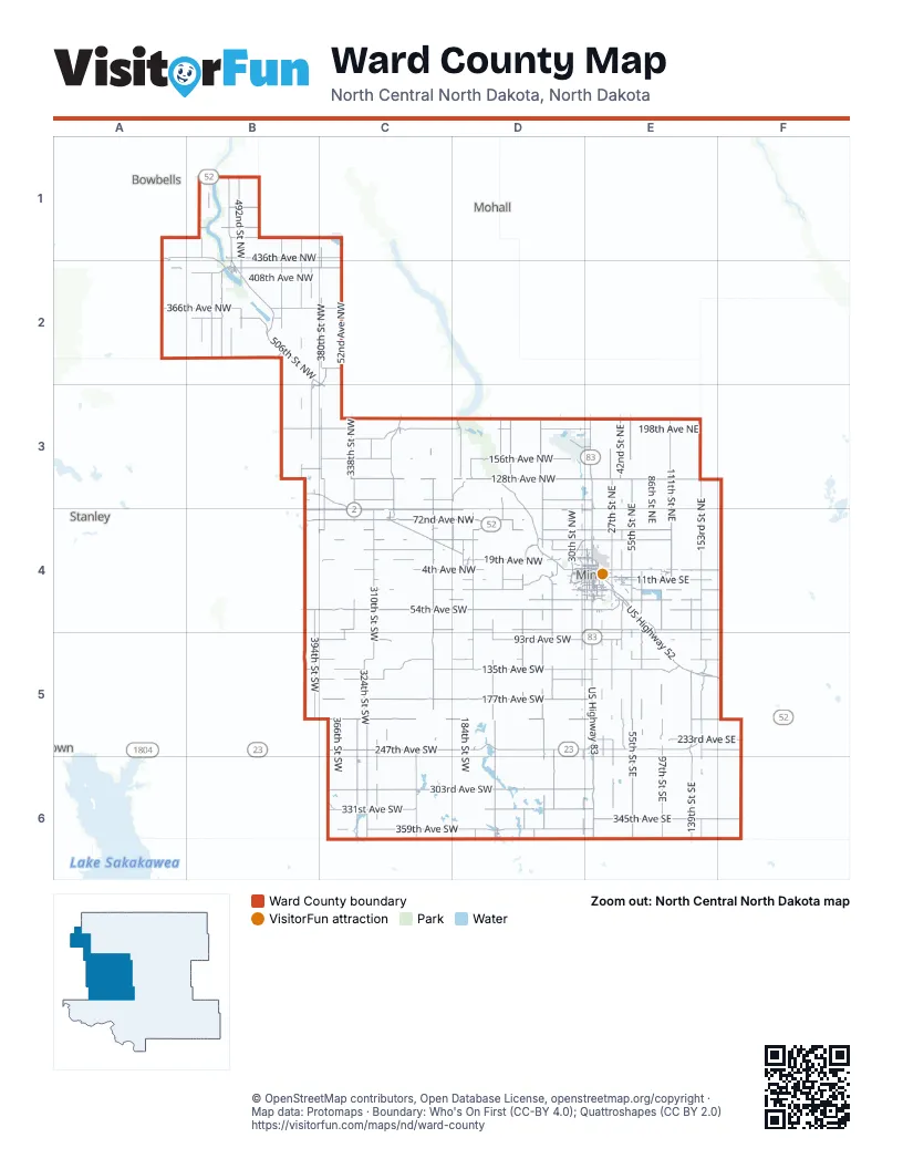
Street index of Ward County
Each street on the sheet and the grid squares it crosses.
- US Highway 2D4, E4
- US Highway 83E3, E4, E5, E6
- 247th Avenue SouthwestC5, D5, E5
- 72nd Avenue NorthwestA1, A2, C4, D4
- 86th Avenue NorthwestB4, C4, D4, E4
- 506th Street NorthwestB1, B2
- 55th Street SoutheastE4, E5, E6
- US Highway 52E4, E5, F5
- 55th Street NortheastE3, E4
- 247th Avenue SoutheastE5, F5
- US Highway 83 BypassD4, E4
- County Highway 13D4, D5, D6
- 233rd Avenue SoutheastE5, F5
- 4th AvenueE4, F4, C6, D6
- 46th Avenue NortheastE4
- North BroadwayE4
- South BroadwayE4
- United States Highway 52B1
- State Highway 23D5, E5
- Burdick Expressway EastE4
- State Highway 5B1
- Valley StreetE4
- Burdick Expressway WestD4, E4
- United States Route 52D4
- 2nd AvenueB2, C2, C3, D4, C6, D6
- 22nd Avenue SouthwestD4, E4
- Western Avenue SouthwestD4, E4
- US-2 BusinessE4
- Highway 2-52E4
- US-83 SE4
- US-83 NE4
- US 83 BypassD4, E4
- US-83 Bypass SD4
- US-2 EE4
- 359th Avenue SouthwestC6, D6, E6
- State Highway 28C3, C4, C5, C6
- 4th Avenue NorthwestB2, C4, D4, E4
- 16th Street SouthwestD4, E4, D5, D6, E6
- 20th Avenue SouthwestC4, D4, E4
- State Highway 50A2, B2
- 37th Avenue SouthwestC4, D4, E4
- 5th Avenue SouthwestD4, E4
- County Highway 24D6
- 3rd Avenue NorthwestB2, C4, D4, E4
- County Highway 14AD4
- 78th Street NorthwestB2
- 54th Avenue SouthwestB4, C4, D4, E4
- 303rd Avenue SouthwestC6, D6, E6
- 177th Avenue SouthwestC5, D5, E5
- 135th Avenue SouthwestB5, C5, D5, E5
- 139th Street SoutheastE4, E5, E6
- 128th Avenue NorthwestB3, C3, D3, E3
- 380th Street NorthwestC1, C2, C3, C4
- 198th Avenue NorthwestB3, C3, D3, E3
- 331st Avenue SouthwestC6, D6, E6
- 97th Street SoutheastE4, E5, E6
- 324th Street SouthwestC5, C6
- County Highway 10B4, C4, D4, E4
- 156th Avenue NorthwestC3, D3, E3
- 153rd Street SoutheastE4, E5, E6
- 72nd Street NorthwestC3, D3, E3, D4
- 93rd Avenue SouthwestB5, C5, D5, E5
- 436th Avenue NorthwestA1, B1, C1
- 310th Street SouthwestC4, C5, C6
- 62nd Street SouthwestD4, D5, D6
- 72nd Street SouthwestD4, D5, D6
- 338th Street SouthwestC4, C5, C6
- 345th Avenue SoutheastE6, F6
- 111th Street NortheastE3, E4
- 366th Avenue NorthwestA2, B2, C2
- 27th Street SoutheastE4, E5, E6
- 205th Avenue SouthwestC5, D5, E5
- 79th Avenue SoutheastE4, F4
- 19th Avenue NorthwestC4, D4, E4
- 100th Avenue NorthwestB3, C3, D3, E3
- 27th Street NortheastE3, E4
- 128th Avenue NortheastE3
- 408th Street NorthwestB1, B2, B3, B4
- 422nd Avenue NorthwestA2, B2, C2
- 170th Street SouthwestD4, D5, D6
- 226th Street SouthwestC4, C5
- 492nd Street NorthwestB1, B2
- 30th Avenue NorthwestD3, C4, D4, E4
- 42nd Street SoutheastE4, E5, E6
- 72nd Street SoutheastE4, E5
- 394th Street SouthwestB4, B5
- 46th Avenue NorthwestC4, D4
- 142nd Street SouthwestD4, D5
- 100th Street SouthwestD4, D5, D6
- 79th Avenue SouthwestC4, D4, E4
- 338th Street NorthwestC3, C4
- 11th Avenue SoutheastE4
- 534th Street NorthwestB1, B2
- 149th Avenue SouthwestB5, C5, D5, E5
- 226th Street NorthwestC3, C4
- County Road 6D3, E3
- 42nd Street NortheastE3, E4
- 128th Street NorthwestD3, D4
- 436th Street NorthwestB1, B2
- 153rd Street NortheastE3, E4
- 135th Avenue SoutheastE5
- 62nd Avenue NorthwestB1, B4, C4, D4, E4
- Frontage RoadD4, E4
- 37th Avenue SoutheastE4
- 20th Avenue SoutheastE4, F4
- 520th Street NorthwestB2
- County Highway 15D3, D4, D6
- 310th Street NorthwestC3, C4
- 54th Avenue SoutheastE4, F4
- 13th Street SoutheastE4, E5, E6
- 184th Street NorthwestD3, D4
- 394th Street NorthwestB2, B3
- 114th Street NorthwestD3, D4
- County Highway 6C3, D3
- 121st Avenue SouthwestB5, C5, D5, E5
- 170th Street NorthwestD3, D4
- County Highway 11D3, C5
- 62nd Avenue NortheastE4
- 352nd Avenue NorthwestB2, C2
- 121st Avenue SoutheastE5, F5
- 52nd Avenue NorthwestC2
- County Road 5B2, C2, B3, C3, C4, C5
- 464th Avenue NorthwestB1
- 350th Street NortheastC1, C2
- County Road 5WB3, C3, C4
- County Highway 19E4, E5
- 93rd Avenue SoutheastE5
- 11th Avenue SouthwestC4, D4, E4
- 66th Avenue NorthwestB1, B2
- 478th Avenue NorthwestB1
- 16th Street NorthwestD3, D4
- 198th Street NorthwestD3, D4
- 548th Street NorthwestB1, B2
- 4th Avenue NortheastB2, C4, E4
- County Highway 23E4, E5
- County Highway 8B3, C3, E3
- County Highway 15WD4
- 22nd Street SouthwestD4
- Railway Avenue NortheastE4
- County Highway 20C5, E5, F5
- 415th Avenue NorthwestB2
- 22nd Avenue NorthE3
- 2nd Street SoutheastE4
- 16th Avenue SoutheastE4
- 8th Street NorthwestB2, E4
- Missile AvenueD3, E3
- South Main StreetC4, D4, E4
- Main StreetC2, C3, D4, C6, D6
- County Highway 4B2
- County Highway 1B1, B2
- 21st Avenue NorthwestD4, E4
- 2nd Avenue SouthwestD4, E4, E5
- 1st Street SoutheastE4
- 62nd Street NorthwestD3, D4
- 296th Street SouthwestC5
- 3rd Street NortheastB2, E4
- 11th Avenue NorthwestD4, E4
- 18th Avenue SoutheastE4
- 1st Street SouthwestE4
- Central Avenue WestC4, D4, E4
- 5th Avenue NorthwestB2, D4, E4
- Railroad Avenue NortheastE4
- 5th Avenue SoutheastD4, E4
- 282nd Avenue NorthwestC2
- Main Street NorthC4, E4
- 1st Avenue SouthwestB2, C4, D4, E4
- 6th Street SouthwestE4
- 6th Street NorthwestB2, E4
- 10th Street SouthwestE4
- 20th Avenue NorthwestD4, E4
- 16th Avenue SouthwestD4, E4
- 6th Street SoutheastE4
- County Highway 18C5
- County Highway 10AD4
- 21st Avenue SoutheastE4
- 7th Street NortheastB2, E4
- 3rd Street SoutheastE4
- 42nd Street NorthwestB5, C5
- 54th Street NorthwestD4
- 1st Avenue SoutheastB2, C4, E4
- 31st Avenue SoutheastE4
- 31st Avenue SouthwestD4, E4
- 5th Avenue NortheastB2, E4
- 1st Street EastC3, E5
- University Avenue WestD4, E4
- Central Avenue EastC4, E4
- 6th Avenue NortheastB2, E4
- County Highway 19 SouthE4
- North Central AvenueB1, B2
- 14th Avenue SouthwestD4, E4
- 6th Street NortheastB2, E4
- 8th Avenue SoutheastE4
- County Highway 2AA1
- Colton AvenueD4
- 18th Street SouthwestD4
- 19th AvenueD4, E4
- 1st Street WestE5
- Cameron Township RoadD6
- Hiawatha Street SoutheastE4
- 9th Street SoutheastE4
- 2nd Avenue SoutheastB2, E4
- 7th AvenueD4, C6
- 14th Avenue SoutheastE4
- 121st Avenue SotuhwestC5
- County Highway 9C5
- 38th Street SoutheastE4
- 7th Avenue SoutheastB2, E4
- 11th Avenue NortheastE4
- Meadow Brook RoadE4
- 16th Street SoutheastE4
- Dakota AvenueE5
- County Highway 12D4
- Front Street SoutheastE4
- Airport RoadE4
- 23rd Avenue NorthwestE3, E4, E6
- 6th Avenue NorthwestE4
- County Highway 2A1, B2
- 5th Street SoutheastE4
- Evergreen AvenueD4
- County Road 17A1, D4
- 51st Street NorthF4
- Eastern AvenueE4
- Washington Avenue EastC3
- County Road 9 SouthD3
- 17th Street SouthwestD4
- University Avenue EastE4
- County Road 20A2
- County Road 26C2
- 31st StreetE4
- 43rd Avenue NorthwestD6
- Ward StreetC6
- County Highway 1AB2
- Power StreetC2
- County Road 11E3
- 53rd Street NorthwestB4
- 57th Avenue NorthwestC6
- 51st Avenue NorthwestC3
- 88th Street NorthwestA1
- 366th Street SouthwestC5, C6
- 184th Street SouthwestD4, D5, D6
- 184th Avenue NorthwestB3, C3, D3
- 167th Street SoutheastE4, E5, E6
- 282nd Street SouthwestC4, C5, C6
- 30th Street NorthwestD3, D4, C6, E6
- 30th Street SouthwestD4, D5, D6
- 30th Avenue NortheastE4, F4
- 111th Street SoutheastE4, E5, E6
- 254th Street NorthwestC3, C4
- 590th Street NorthwestA1, A2
- 125th Street SoutheastE4, E5, E6
- 352nd Street SouthwestC4, C5, C6
- 198th Avenue NortheastE3
- 254th Street SouthwestC4, C5
- 156th Avenue NortheastE3
- 177th Avenue SoutheastE5, F5
- 86th Street SouthwestD4, D5, D6
- 142nd Avenue NorthwestB3, C3, D3, E3
- 233rd Avenue SouthwestC5, D5, E5
- 156th Street SouthwestD4, D5, D6
- 114th Avenue NorthwestB3, C3, D3, E3
- 198th Street SouthwestD4, D5, D6
- 205th Avenue SoutheastE5
- 86th Street NortheastE3, E4
- 46th Street SouthwestD4, D5, D6
- 310th Avenue NorthwestB2, C2
- 478th Street NorthwestB1, B2
- 366th Street NorthwestC1, C2, C3, C4
- 289th Avenue SoutheastE6
- 324th Street NorthwestC3, C4
- 170th Avenue NorthwestC3, D3
- 338th Avenue NorthwestB2, C2
- 212th Street NorthwestC3, C4
- 345th Avenue SouthwestC6, D6
- 125th Street NortheastE3, E4
- 167th Street NortheastE3, E4
- 86th Street SoutheastE4, E5, E6
- 275th Avenue SouthwestC6, E6
- 13th Street NortheastE3, E4
- 261st Avenue SouthwestC6, D6
- 317th Avenue SoutheastE6
- 100th Avenue NortheastE3
- 317th Avenue SouthwestC6, D6
- 219th Avenue SoutheastE5
- 86th Street NorthwestD3, D4
- 268th Street NorthwestC3, C4
- 422nd Street NorthwestB1, B2, B3
- 240th Street SouthwestC4, C5, C6
- 352nd Street NorthwestC2, C3, C4
- 450th Street NorthwestB1, B2
- 296th Street NorthwestC3, C4
- 450th Avenue NorthwestA1, B1, C1
- 562nd Street NorthwestB1, B2
- 268th Street SouthwestC4, C5
- 408th Avenue NorthwestB2, C2
- 394th Avenue NorthwestA2, B2
- 72nd Avenue NortheastE4, F4
- 191st Avenue SouthwestC5, D5, E5
- 107th Avenue SoutheastE5, F5
- 86th Avenue NortheastE4
- 163rd Avenue SoutheastE5
Things to do on the Ward County map
Places on the map
- Berthold
- Bison Plant Trail
- Black Butte
- Burlington
- Carlson Lake
- Carpio
- Dakota Territory Air Museum
- Des Lacs
- Des Lacs Reservoir
- Donnybrook
- Douglas
- East Side Estates Boat Launch
- Flying J Travel Center
- Foxholm
- Hiddenwood Lake
- Jack Hoeven Baseball Park
- Kenmare
- Livingston Lake
- Logan
- Makoti
- Minot
- Minot AFB
- Minot Air Force Base
- Minot Country Club
- Minot Outdoor Recreation Area
- Moose Park
- Nelson Lake
- Oak Park
- OPA
- Optimist Soccer Complex
- Rice Lake
- Roosevelt Park
- Rosehill Cemetery
- Ryder
- Sawyer
- Souris Valley Golf Course
- South Hill Complex
- Surrey
- Wildwood Country Club
Next to Ward County
- Bowbells
- Mohall
- Stanley
© OpenStreetMap contributors, Open Database License, openstreetmap.org/copyright · Map data: Protomaps · Boundary: Who's On First (CC-BY 4.0); Quattroshapes (CC BY 2.0)