

North Dakota map
North Dakota map
The sheet's index lists 300 streets; Main Street, 2nd Avenue and 1st Avenue cross the most grid squares. Things to do inside the boundary: Beaver Lake State Park, Bonanzaville, USA and Cross Ranch State Park. Also on it: Antelope Creek Wildlife Management Area, Arrowwood National Wildlife Refuge and Ashley Municipal Airfield.
Open the map (PDF, US Letter)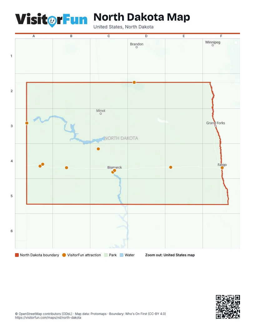
Maps inside North Dakota
15 maps inside, from the street map of North Dakota down.
Regions
Road map
Street index of North Dakota
Each street on the sheet and the grid squares it crosses.
- US Highway 2C3, D3
- West Bismarck ExpresswayC4
- Bismarck ExpresswayC4
- State Highway 200A3, C3, E3, F3, A4, B4, C4, D4, E4, F4
- Theodore Roosevelt ExpresswayA3, A4, A5
- State Highway 5A2, B2, C2, D2, E2, F2
- State Highway 1804A3, B3, C3, C4, C5
- State Highway 32E2, E3, E4, E5
- State Highway 1E2, E3, E4, E5
- State Highway 18E2, E3, F3, F4, F5
- State Highway 13C5, D5, E5, F5
- State Highway 3D2, D3, D4, D5
- State Highway 20D2, E2, E3, E4
- State Highway 14C2, C3, D3, D4
- US Highway 83C2, C3
- Main StreetA2, B2, C2, D2, E2, F2, A3, B3, C3, D3, E3, F3, A4, B4, C4, D4, E4, F4, A5, B5, C5, D5, E5, F5
- State Highway 66D2, E2, F2
- State Highway 17D2, E2, F2
- State Highway 8B2, B3, B4, B5
- State Highway 30D2, D3, D4, D5
- State Highway 1806A3, B3, B4, C4, C5
- State Highway 15D3, E3, F3
- State Highway 46D4, E4, F4
- 19th Avenue NortheastD2, C3, D3, E3, F3, D4, E4, B5
- 64th Street NorthwestA3, B3, C3
- 4th Avenue NortheastA2, B2, C2, D2, A3, B3, C3, E3, F3, A4, B4, C4, D4, E4, B5, D5, E5, F5
- US Highway 52C3, D3, D4
- 55th Street SoutheastC3, C4, D4, E4, F4
- 81st Street SoutheastE4, C5, D5, E5, F5
- 1st Street SoutheastA2, B2, C2, D2, A3, B3, C3, D3, F3, A4, B4, C4, D4, E4, F4, A5, C5, D5, E5, F5
- 55th Street NortheastC2, C3, D3, E3, F3
- State Highway 41C3, C4
- 31st Avenue NortheastD2, D3, E3, F3, D4
- 12th Street NortheastA3, C3, D3, E3, F3, B4, C4, E4, B5
- 1st Street SouthwestA2, B2, B3, C3, D3, F3, A4, B4, C4, D4, F4, A5, D5, E5, F5
- State Highway 19D3, E3
- State Highway 6C4, C5
- 3rd Street SouthwestB2, D2, A3, B3, C3, D3, F3, A4, B4, C4, D4, E4, F4, A5, B5, D5, E5, F5
- 65th Street NortheastC3, D3, E3, F3
- 3rd Street SoutheastA2, B2, C2, D2, A3, B3, C3, D3, E3, F3, A4, C4, D4, E4, F4, A5, B5, D5, E5, F5
- State Highway 28B2, C2, B3, C3
- State Highway 23A3, B3, C3
- United States Highway 52B2, C3, D3, D4
- 43rd Street NortheastC3, D3, E3
- 42nd Street NortheastC2, C3, D3, E3, F3, C4
- 86th Avenue NorthwestB2, B3, C3
- State Highway 49B4, B5
- 57th Street NorthC3, F4
- 62nd Street NortheastC3, D3, E3, F3
- 10th Street SoutheastD2, A3, C3, E3, B4, C4, D4, E4, B5
- 62nd Street NorthwestC2, A3, B3, C3
- 95th Street NorthwestA2, B2, C2
- 3rd Avenue SoutheastA2, C2, D2, E2, A3, B3, C3, D3, E3, F3, A4, B4, C4, D4, E4, F4, A5, B5, C5, D5, E5, F5
- 41st Street NortheastC3, D3, E3, C4
- 46th Avenue NortheastD2, C3, D3, D4
- 2nd AvenueA2, B2, C2, D2, E2, F2, A3, B3, C3, D3, E3, F3, A4, B4, C4, D4, E4, F4, A5, B5, C5, D5, E5, F5
- 12th Street SoutheastD2, A3, C3, B4, C4, D4, E4, F4, B5
- County Road 19B2, C3, D3, E3, F3, B4
- 72nd Avenue NorthwestB2, B3, C3
- 1st Street NortheastA2, B2, C2, D2, B3, C3, D3, E3, F3, A4, B4, C4, D4, E4, F4, A5, B5, C5, D5, E5, F5
- Veterans Memorial HighwayB3, B4, F4
- State Highway 40B2, B3
- 1st Avenue NorthA2, C2, D2, E2, B3, C3, D3, E3, F3, B4, D4, E4, F4, A5, B5, C5, D5, E5, F5
- State Highway 200 AlternateC4, F4
- State Highway 24C5
- Highway 2 EastE3
- 71st Avenue NorthwestB2, B3, B4
- 96th Street NorthwestA2, B2, C2, C3
- 2nd Avenue SouthwestA2, D2, A3, B3, C3, D3, E3, F3, A4, B4, C4, D4, E4, F4, A5, B5, C5, D5, E5, F5
- 149th Avenue NortheastF2, F3, C4, D4
- 4th AvenueA2, B2, C2, D2, E2, F2, A3, B3, C3, D3, E3, F3, B4, C4, E4, F4, A5, C5, D5, E5, F5
- County Highway 13C3, F3, F4
- Main AvenueB2, C2, D2, E2, A3, D3, E3, F3, B4, C4, D4, E4, F4, B5, C5, D5, E5, F5
- Highway 2 WestD3, E3
- 148th Avenue NortheastF2, F3
- 1st AvenueA2, B2, C2, D2, E2, F2, A3, B3, C3, D3, E3, F3, B4, C4, D4, E4, F4, A5, B5, C5, D5, E5, F5
- 1st Avenue SouthwestB2, D2, B3, C3, D3, E3, F3, A4, B4, C4, D4, F4, A5, B5, C5, D5, E5, F5
- 19th Avenue NorthC2, C3, F4
- Yellowstone TrailA5, B5
- 1st Street NorthwestA2, B2, C2, D2, B3, C3, D3, E3, F3, B4, C4, D4, F4, A5, C5, D5, E5, F5
- 18th AvenueE2, C3, F3, F5
- 5th Street NorthwestA2, B2, C2, A3, C3, A4, B4, C4, D4, E4, F4, A5, B5, D5, E5
- 74th Avenue NorthwestB2, B3, C3, B4
- 1st Avenue NorthwestB2, C2, D2, B3, C3, D3, F3, A4, B4, C4, D4, F4, A5, B5, C5, D5, E5, F5
- 7th Avenue SoutheastA2, B2, D2, B3, C3, D3, E3, F3, A4, C4, E4, B5, D5, F5
- 57th Street NorthwestA3, B3
- 4th Avenue NorthC2, D2, C3, D3, F3, B4, D4, F4, B5, C5, E5, F5
- 17th Street SouthwestC3, B4, C4, E4
- State Highway 68A3
- 151st Avenue NortheastF2, F3
- 3rd Avenue SouthwestA2, D2, A3, B3, C3, D3, E3, F3, A4, B4, C4, D4, E4, F4, A5, B5, C5, D5, E5, F5
- 2nd StreetA2, B2, C2, D2, E2, F2, A3, B3, C3, D3, E3, F3, A4, C4, D4, E4, F4, A5, B5, C5, D5, E5, F5
- 61st Avenue SouthwestB4, B5, C5
- 79th Avenue NorthwestB2, B3, B4
- 84th Avenue NorthwestB2, B3, C4
- 4th Avenue SouthwestD2, A3, B3, C3, E3, A4, B4, C4, D4, E4, F4, A5, B5, C5, D5, E5, F5
- 6th Avenue SoutheastA2, D2, A3, B3, C3, D3, E3, F3, A4, B4, C4, E4, F4, D5, E5, F5
- County Road 33C2, C3, F3, D5, E5
- 39th Street NorthwestA3, B3
- 1st StreetA2, B2, D2, E2, F2, A3, C3, D3, E3, F3, C4, D4, E4, F4, A5, B5, C5, D5, E5, F5
- 247th Avenue SouthwestB3, C3
- 116th Avenue SouthwestB4
- 506th Street NorthwestB2
- 4th Street NorthwestA2, B2, C2, D2, A3, B3, C3, E3, F3, A4, B4, C4, D4, E4, F4, A5, B5, D5, E5, F5
- 134th Avenue NorthwestA2, A3
- 33rd Street SouthwestC3, A4, B4, F4
- 77th Avenue NorthwestB2, B3
- State Highway 127F5
- Main Street EastC2, E2, D3, F3, B4, C4, D4, E4
- 1st Street NorthA3, B3, D3, E3, B4, C4, D4, E4, F4, B5, E5, F5
- 4th Avenue SouthC3, D3, F3, D4, F4, B5, D5, E5, F5
- 17th Street NorthwestA3, B3, C3, C4, E4, B5
- 45th Street NorthC3, F3, F4
- 80th Avenue NorthwestB2, B3
- 5th StreetD2, E2, F2, B3, C3, D3, E3, F3, A4, B4, C4, D4, E4, F4, A5, B5, D5, E5, F5
- 26th AvenueE3, F3, C4, C5
- 143rd Avenue NorthwestA2, A3
- CanAm HighwayA2
- South University DriveF4
- North Washington StreetF3, C4
- Highway 23A3
- 1st Avenue SouthA2, D2, C3, D3, E3, F3, B4, D4, E4, F4, C5, D5, E5, F5
- 5th Street NorthD2, E2, B3, D3, E3, B4, C4, D4, F4, B5, E5, F5
- State Highway 57D3, E3
- United States Highway 281D2
- 45th Street SouthF4
- Gateway DriveE2, F3, F4
- 247th Avenue SoutheastC3
- South Washington StreetF3, C4
- West Main StreetD3, E3, B4, C4, E4, D5, E5
- United States Highway 81F2
- Railway StreetB2, C3, D3, F3, C4, D4, E4, A5, B5, D5, E5
- State Highway 73B3, B5
- 233rd Avenue SoutheastC3
- United States Highway 2E3
- Dakota ParkwayA3
- 2nd Avenue WestB2, C2, D2, A3, B3, C3, E3, B4, C4, D4, F4, A5, B5, C5, D5, E5, F5
- 38th Street SouthF4
- State Highway 4D2
- 1st Street SouthD2, B3, D3, E3, A4, B4, C4, D4, E4, F4, B5, D5, E5, F5
- US Highway 83 BypassC3
- US-52B2, D3, D4
- 3rd Avenue WestB2, C2, D2, A3, B3, C3, E3, B4, D4, F4, A5, B5, C5, E5
- State StreetD2, F3, C4, D4
- 11th Street WestC2, A3, D3, B4, F4
- 32nd Avenue SouthF3
- 23rd AvenueC3, E3, C4, C5
- 136th Avenue NorthwestA2, A3, C4
- Demers AvenueD2, F3
- 2nd Street WestB2, C2, D2, E2, A3, B3, C3, D3, E3, B4, C4, D4, F4, B5, D5, F5
- Main Street SouthA2, B2, A3, B3, C3, A4, B4, C4, F4, E5, F5
- 52nd Avenue SouthF3, F4
- 13th Avenue SouthF3, D4, F4
- Highway 281 NortheastD3, D4
- 12th AvenueE2, E3, C4, E4
- 1st Street EastA2, B2, C2, D2, A3, B3, C3, D3, E3, B4, C4, D4, E4, F4, B5, D5, E5, F5
- 1st Street WestA2, B2, C2, D2, A3, B3, C3, D3, B4, C4, D4, E4, F4, B5, D5, E5
- 3rd Street EastA2, C2, E2, A3, B3, C3, D3, E3, B4, C4, F4, B5, D5, E5
- Main Street NorthB2, A3, B3, C3, E3, A4, B4, C4, D4, F4, E5, F5
- ND-22B4, B5
- Dakota AvenueA3, C3, D3, F3, C4, D4, E4, F4, B5, F5
- Highway 58A3
- 7th Street NorthB3, E3, F3, C4, D4, F4, B5, E5, F5
- Main Avenue WestD2, B4, F4
- Main Street WestC2, E2, D3, F3, B4, C4, D4
- South Main StreetA2, F2, B3, C3, B4, C4, A5, B5, C5, E5
- East Bismarck ExpresswayC4
- East Main AvenueC4
- North BroadwayC3, D5
- Washington AvenueA2, B2, A3, B3, D3, E3, F3, B4, D4
- 7th Street SouthF2, D3, E3, B4, C4, D4, F4, B5, D5, E5, F5
- 10th Street NorthD3, F4, E5, F5
- South Main AvenueD2, D3, B4
- Lincoln AvenueC3, D3, E3, B4, C4, D4, E4, F4
- North Dakota Highway 1E5
- 9th AvenueD2, E2, C3, F3, C4, E4, F4, C5, E5, F5
- South BroadwayC3, D5
- Pacific AvenueB2, E2, F3, A4, C4, B5, E5
- Memorial HighwayC4
- North 4th StreetF2, F3, C4, B5, F5
- 24th Avenue SouthwestA3, C3, E3, C4, E4
- North University DriveF4
- North Main StreetA2, F2, B3, C3, C4, D4, F4, A5, B5, C5
- 7th Avenue EastA3, B3, B4, F4, B5, E5
- East Main StreetC3, E3, A4, B4, C4, E4, D5, E5
- State Highway 23B TruckB3
- Main Avenue EastD2, F4, D5
- Railway AvenueB2, C2, D2, C3, D3, E4, C5
- State Highway 22 BusinessB4
- 11th Street SouthF4, B5, E5, F5
- 10th Street SouthD3, B4, C4, F4, B5, D5, E5
- 9th Street SouthD3, C4, F4, B5, D5, E5
- Center StreetC4, E4, F4, A5, D5, E5
- West StreetC2, A3, C3, F3, A4, C4, A5, B5, C5
- 10th Street WestC2, A3, D3, F4
- North 5th StreetF2, F3, C4, D5
- Highway 200A3
- Burdick Expressway EastC3
- 9th Avenue EastE2, A3, B4, F4, E5
- South 20th StreetF3, C4
- Valley StreetA2, C3, E5, F5
- South 34th StreetF3
- State Highway 58A3
- East Villard StreetB4
- 11th Street EastC2, A3, B4, F4
- East Boulevard AvenueC4
- US 52 BypassE4
- State Highway 97C3
- Park Street EastE2, D4, F5
- Highway 1806 WestA3
- North 1st StreetF3, C4, B5, D5, E5, F5
- West 12th StreetF2, B4
- Burdick Expressway WestC3
- East 12th StreetF2
- East 3rd StreetC2, E2, F2, E3, B4, B5
- Highway 85 NorthA3
- College Drive NorthE3
- North 7th StreetF3, C4
- South StreetC2, E2, E3, B4
- Minnesota AvenueC3, F3, C4, E4, F4, B5, F5
- Broadway Street NorthD5
- South 38th StreetF3
- East BroadwayA3
- Adams AvenueC3, D3, F3, B4, B5
- United States Route 52C3
- West Main AvenueC4, E5
- North 9th StreetF3, C4, D5
- Interstate 94 Business Loop EastB4
- South 9th StreetF3, C4
- 18th Street WestA3, B4
- 22nd Avenue SouthwestA3, C3, C4
- Cass AvenueA3, E4
- West Villard StreetB4
- Governor's DriveF4
- Hill AvenueF2
- State Highway 59F2
- 10th Street EastC2, D3, F4
- West Business LoopE4
- South 7th StreetC4
- Villard Street WestB4
- Elk StreetA3
- Main Street NorthwestA2, B2, E5
- Beaver AvenueD5
- 20th Avenue EastA3, F4
- South 23rd StreetF3, C4
- Division Avenue NorthE2
- Delano AvenueE2
- Towner AvenueE3
- Avenue A EastC4, D5
- Main Street SouthwestB2, E5
- Parke AvenueF3
- Donald StreetA4
- East Railroad AvenueA3
- Business Loop EastE4
- Langer Avenue SouthF4
- Highway 52/200 NortheastD4
- Oil Capital Way NorthB2
- West Rosser AvenueC4
- Bates StreetF3
- Central Avenue SoutheastB4
- Brewster StreetD3
- SD Highway 127F5
- Avenue A WestC4, D5
- Brewster Street EastD3
- Wheat StreetE4
- Oil Capital Way SouthB2
- Main SouthB4
- Western Avenue SouthwestC3
- College Drive SouthE3
- Central Avenue NorthwestC3, B4
- Langer Avenue NorthF4
- West Railroad AvenueA3
- South Saint Paul AvenueD5
- West Main RoadC3
- United State Highway 52D3
- South 31st StreetF3
- Dakota Avenue SouthF3
- State Highway 171F2
- State Highway 23 BusinessA3
- East Main RoadC3
- US-2 BusinessC3
- Ohmer AvenueD2
- US-83 NC3
- Highway 2-52C3
- US-83 SC3
- SD Highway 37E5
- Old State Highway 8B2
- State Highway 23AA3
- US Highway 281E5
- US Highway 85A5
- Lord Selkirk HighwayF2
- US 83 BypassC3
- US-83 Bypass SC3
- Fort McKeen RoadC4
- US 281E4
- South 3rd Avenue WestB4
- Highway 39B2
- United States Highway 52 BusinessD3
- US-83C2
- Provincial Trunk Highway 32E2
Things to do on the North Dakota map
- Beaver Lake State Park
- Bonanzaville, USA
- Cross Ranch State Park
- Enchanted Highway
- Fargo Air Museum
- Fargo Theatre
- Fort Abraham Lincoln State Park
- Fort Ransom State Park
- Fort Stevenson State Park
- Fort Totten State Historic Site
- Fort Union Trading Post National Historic Site
- Grand Cities Mall
- Icelandic State Park
- Knife River Indian Villages National Historic Site
- Medora Musical
- North American Bison Discovery Center
- North Dakota Heritage Center & State Museum
- North Dakota State Capitol
- North Dakota Tourism Division
- Plains Art Museum
- Red River Zoo
- Ronald Reagan Minuteman Missile State Historic Site
- Roosevelt Park Zoo
- Theodore Roosevelt National Park
- Theodore Roosevelt Presidential Library
- West Acres Shopping Center
- World's Largest Buffalo Monument
Places on the map
- Antelope Creek Wildlife Management Area
- Arrowwood National Wildlife Refuge
- Ashley Municipal Airfield
- Audubon National Wildlife Refuge
- Audubon Wildlife Management Area
- Brinkman WPA
- Camp Grafton
- Cavalier County Wildlife Management Area
- Cedar River National Grassland
- Chase Lake WPA
- Coteau Prairie WPA
- Crimmins WPA
- Cross Ranch State Park
- Dakota Lake National Wildlife Refuge
- de Trobriand Wildlife Management Area
- Deepwater Creek Wildlife Management Area
- Des Lacs National Wildlife Refuge
- Douglas Creek Wildlife Management Area
- Fargo Air National Guard Base
- Grahams Island State Park
- Grand Forks Air Force Base
- Graner Bottoms Wildlife Management Area
- Hille Wildlife Management Area
- Hofflund Wildlife Management Area
- J. Clark Salyer National Wildlife Refuge
- Lewis and Clark Wildlife Management Area
- Little Missouri National Grassland
- Little Missouri State Park
- Lonetree Wildlife Management Area
- Long Lake National Wildlife Refuge
- Lostwood National Wildlife Refuge
- National Waterfowl Production Area
- Palensky Waterfowl Production Area
- Pembina Hills Wildlife Management Area
- Prarie Chicken Wildlife Management Area
- Sheyenne National Grassland
- Theodore Roosevelt National Park
- Trenton Wildlife Management Area
- Upper Souris Wildlife Refuge
- Van Hook Wildlife Management Area
Next to North Dakota
- Brandon
- Winnipeg
© OpenStreetMap contributors, Open Database License, openstreetmap.org/copyright · Map data: Protomaps · Boundary: Who's On First (CC-BY 4.0); Quattroshapes (CC BY 2.0)