

Nebraska map
Bellevue map
About 64,777 people live here (Census Bureau, 2024 estimate). The sheet's index lists 300 streets; South 35th Street, South 36th Street and Kennedy Freeway cross the most grid squares. Also on it: 25th Street, American Heroes Park and American Heros Park.
Open the map (PDF, US Letter)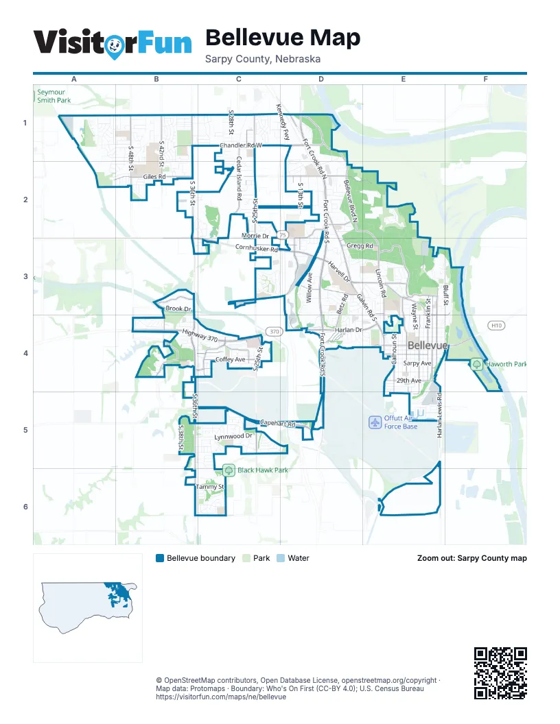
Street index of Bellevue
Each street on the sheet and the grid squares it crosses.
- Kennedy FreewayD1, D2, D3, D4, D5
- Fort Crook Road SouthD2, D3, D4, D5
- Highway 370B4, C4, D4
- Cornhusker RoadB2, B3, C3, D3
- Harlan DriveD4, E4
- Galvin Road SouthD3, E3, E4
- Fort Crook Road NorthD1, D2
- Harvell DriveD3, E3
- South 13th StreetD1, D2, D3, D5
- West Mission AvenueE4
- East Mission AvenueE4, F4
- Bellevue Medical Center DriveC4
- Meyer AvenueD5
- South 36th StreetB1, B2, B3, B4, B5, B6
- South 25th StreetC1, C2, C3, C4, C5
- Capehart RoadB5, C5, D5
- Chandler Road WestB1, C1, D1
- Bellevue Boulevard NorthD1, D2, E2, E3
- Lincoln RoadE3, E4
- Bellevue Boulevard SouthE3
- Franklin StreetE3, E4
- Gregg RoadC3, D3, E3
- South Harvell DriveE3, E4
- Galvin Road NorthD2, D3
- Railroad AvenueD1
- O'Malley CircleE4
- South 48th StreetB1, B2, B4
- Betz RoadD3, D4
- South 15th StreetD2, D3
- Cedar Island RoadC1, C2
- Washington StreetE3, E4, E5
- Main StreetE3, E4
- Hancock StreetE3, E4, E5
- South 42nd StreetB1, B2, B3, B4
- Harlan Lewis RoadE4, E5, E6
- Giles RoadA2, B2
- Childs Road WestC2, D2
- Golden BoulevardC4
- Childs Road EastD2, E2
- Coffey AvenueB4, C4
- Calhoun StreetE4, E5
- South 26th StreetC1, C2, C4
- Quail DriveB4
- Lloyd StreetD3
- Duane AvenueB4, C4
- Jackson StreetE4, E5
- Thurston AvenueD2, D3
- Raynor ParkwayB3
- West 24th AvenueE4
- West 29th AvenueE4
- Schneekloth RoadC6
- Freeman DriveE3, E4
- Avery Road EastD2
- Jewell RoadE3
- East 16th AvenueF3, E4, F4
- Meisinger RoadC2
- Maass RoadB4
- Granada ParkwayB4, C4
- Chandler Road EastD1
- West 16th AvenueE3, E4
- East 13th AvenueE3
- Avery Road WestD2
- Park AvenueE3
- East 29th AvenueE4
- West 13th AvenueE3
- Lockbourne DriveB4
- Nelson DriveD4
- South 30th StreetC1, C2, C5
- South 35th StreetB1, C1, B2, B4, C4, C5, B6, C6
- Gertrude StreetA1, B1, C1, D1
- Virginia StreetA2, B2, C2, D2
- Emiline StreetA1, B1, C1, D1
- Lynnwood DriveB5, C5, D5
- Green Acres MHPE4, E5
- Jefferson StreetE3, E4
- Greene AvenueB1, C1, A2, B2, C2
- Wayne StreetE3, E4
- Leawood DriveB5, C5
- Madison StreetE3, E4, E5
- South 33rd StreetC1, C4, C5
- Fort Crook Frontage RoadD2, D3, D4
- Josephine StreetB1, C1, D1
- South 38th StreetB1, B2, B5
- South 34th StreetC2, C4, C5, C6
- Camp Gifford RoadD2, E2
- Twin Creek DriveB4
- Joann AvenueB4, C4
- Martin Drive NorthE2
- Margo StreetB1, C1
- South 21st StreetC1, C2, C3, C5
- Bryan AvenueD3
- Lillian StreetB1, C1
- Nottingham DriveC5
- Van Buren StreetE4
- Samson WayB4, C4
- South 17th StreetD1, D2, C3, D3
- South 28th StreetC1, C4, C5
- Nebraska DriveD1, D2
- Thomas DriveD3, D4
- Willow AvenueD3
- Warren StreetE3, E4, F4
- Olive StreetB1, C1
- South 45th AvenueB1, B2
- South 18th StreetC1, D1, C3
- South 31st StreetC1, C4, C5, C6
- Bluff StreetE3, F3, E4, F4
- South 41st StreetB1, B2
- Crawford StreetE4
- South 9th StreetD2, D5
- South 41st AvenueB1
- South 40th StreetB1, B2
- SP Benson DriveC2, C3
- South 39th StreetB1, B2, B4
- Looking Glass DriveB5, C5
- West 23rd AvenueE4
- Kountze Memorial DriveE3, F3
- Cascio DriveD3, E3
- Arboretum DriveD4
- Victoria AvenueD3
- Wilshire DriveD3, D4, E4
- Englewood DriveD3, E3, D4
- Robin DriveA2, B2, C2, E4
- Brook DriveB3
- Hogantown DriveC3, D3
- South 43rd StreetB1, B4
- Hidden Hills DriveE3
- Kayleen DriveD3
- South 39th AvenueB1, B2
- South 49th StreetB1, B2
- Payne DriveF4
- Bernadette AvenueA1, B1
- South 50th StreetA1, A2
- Alberta AvenueC2, D2
- Georgia AvenueC2, D2
- West 27th AvenueE4
- Martin DriveE2, E3
- Morrie DriveC2
- Sarpy AvenueC1, C2
- Camp Brewster RoadD1, D2
- Sun Valley DriveA1
- Aspen DriveA1, B1
- Comstock AvenueB4, C4
- Hackberry CourtE2, E3
- Krammer Park PlazaF4
- Rahn BoulevardC6
- Marian AvenueE3
- West 25th AvenueE4
- West Sarpy AvenueE4
- Ponderosa DriveC4
- Chandler Hills DriveC1
- Schuemann DriveB5, C5
- Courtney DriveC5
- South 22nd StreetC1, C5
- Herman DriveD3
- Chandler Acres DriveC1
- South 24th StreetC2, C5
- South 37th StreetB1, B4
- South 25th AvenueC1, C2, C4
- Spring BoulevardC6
- Greensboro AvenueD3
- West 31st AvenueE4
- Front StreetF3
- Longview StreetB4
- South 23rd StreetC1, C3, C5
- Glasgow AvenueA1, B1
- Tammy StreetC6
- Forest DriveE2, E3
- South 11th StreetD2, D3
- River DriveF4
- South 52nd StreetA1
- Sheridan RoadB5, C5
- North 4th StreetD2
- South 26th AvenueC4, C5
- Sidney StreetC1, D1
- Grove RoadD2, E2
- Chaput DriveD2, E2
- Paradise TerraceE5
- Logan AvenueE3
- Arrow Rock DriveA1
- South 19th StreetC1, C3
- South 47th StreetB1, B2, B4
- South 29th AvenueC5
- Offutt BoulevardD4, E4
- Edna StreetB1, C1
- South 29th StreetC5
- Hillcrest DriveD4
- Douglas DriveE3
- South 10th StreetD2, D3
- West 22nd AvenueE4
- Mark StreetB4
- South 20th StreetC1, C2, C5
- Garden AvenueD3, D4
- Bellaire BoulevardD4, E4
- Ridgewood DriveE2
- Amos Gates DriveB4
- South 46th AvenueB1, B2
- South 53rd StreetA1
- South 27th StreetC1, C4
- Cornelia StreetC2, D2
- Combs RoadE3
- Red Rock AvenueA1, B1
- Tamarac DriveB2, C2
- Linden AvenueC2, C3
- Birchwood DriveB6, C6
- South 28th AvenueC5
- Blackhawk DriveB5, C5
- Fort Crook West Frontage RoadD2
- Fairview StreetC2, D2
- Jack Pine StreetC4
- Gayle AvenueB4
- South 21st AvenueC1, C2
- Ridge RoadE3
- Tulip LaneC2, D2
- Martinview RoadD4
- Saint Andrew's RoadE3
- Twin Ridge DriveD3, D4
- South 35th AvenueB5
- Borman StreetB1
- Comstock PlazaC4
- South 32nd StreetC1
- Kings DriveD3
- Lorraine DriveE3
- Kay Lynn DriveE3, E4
- West 20th AvenueE4
- Lemay DriveE3, E4
- Suburban DriveB1
- Pelton AvenueE4
- High School DriveE3
- Glenmorrie DriveB1
- Century RoadC5
- Smith RoadD2
- Cunningham RoadE6
- South 41st TerraceB1, B2
- Chateau DriveD3
- Schilling DriveD5
- South 49th AvenueB1, B2
- Brookside DriveB5
- Fairfax RoadD3, E3
- West 32nd AvenueE4
- Kasper StreetD2
- Wall StreetD4, E4
- Copper Hill DriveA1, B1
- Harrison StreetC1, D1
- East 20th AvenueE4, F4
- South 48th AvenueB1, B2
- Westridge AvenueD4
- Cherry LaneB1, C1, E3
- Columbus AvenueD2
- BMC DriveC4
- Schroeder DriveB2
- Pleasantview LaneD2
- Galvin East Frontage RoadD3
- Sycamore StreetD3, E3
- Lee DriveC2, E3
- Sunshine BoulevardD3
- Virginia AvenueD2
- East 19th AvenueE4, F4
- Grandview AvenueD2
- Harrington AvenueE3
- Sherry DriveD3
- South 9th AvenueD2
- Duane PlazaC4
- Redwing DriveC5
- Calvin StreetC2
- East 22nd AvenueE4, F4
- Edwards StreetD1
- Blue Ridge DriveC1
- Kohl RoadD2
- Holly StreetB2, C2
- South 50th AvenueA1, A2
- 36th PlaceE5
- Lorraine AvenueD3, E3
- East 35th AvenueE5
- Whitted DriveC5
- Gindy DriveC2
- Kingston AvenueD3
- Pratt AvenueC3
- Rose Lane RoadC2
- Brighton DriveC5
- Sherwood DriveB2, C2
- Lindyview LaneD2
- Trail Creek AvenueA1, B1
- Bayberry DriveE2
- Clay StreetE4
- West 19th AvenueE4
- Parkway DriveE4
- Anchor Mill DriveB4
- Sunset DriveD4, E4
- High Meadow LaneB1
- Hillcrest AvenueD2, D3
- Power DriveD3
- South 44th StreetB1, B2, B4
- Potter RoadE3
- Amerado BoulevardC4
- East 21st AvenueE4
- Linda StreetC2
- Terry AvenueD3
- Greenfield RoadC1
- Caldor DriveD2, D3
- Country Club CourtE2
Places on the map
- 25th Street
- American Heroes Park
- American Heros Park
- Aspen Park
- Baldwin Sports Complex
- Bellaire Elementary School
- Bellevue Cemetery
- Bellevue Christian Center
- Bellevue East High School
- Bellevue Medical Center
- Bellevue Public Library
- Bellevue Soccer Club
- Bellevue University
- Bellevue West High School
- Birchcrest Elementary School
- Central Elementary School
- Champions Village
- College Heights Park
- Copper Creek Park
- Cornhusker Center
- Cornhusker Pointe
- Cornhusker Retail Center
- Daniel Crossing
- Daniel J Gross Catholic High School
- Don Roddy Sports Complex
- Everett Park
- Faulkland Park
- Fontenelle Golf Course
- Haworth Park
- Haworth Park Campground
- Jewell Park
- Olde Towne
- Omaha Bryan High School
- Paradise Park Lake
- Sun Valley Landscaping
- Swanson Park
- Twin Creek Plaza
- Twin Creek Plaza North
- Wolf Creek
- Woodhouse Nissan
© OpenStreetMap contributors, Open Database License, openstreetmap.org/copyright · Map data: Protomaps · Boundary: Who's On First (CC-BY 4.0); U.S. Census Bureau