

Nebraska map
Sarpy County map
About 204,828 people live here (Census Bureau, 2024 estimate). The sheet's index lists 300 streets; Platteview Road, Lincoln Road and Cornhusker Road cross the most grid squares. Things to do inside the boundary: Shadow Lake Towne Center.
Open the map (PDF, US Letter)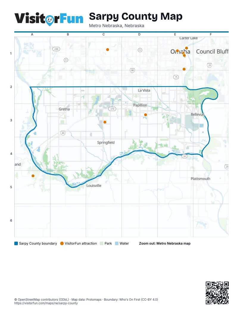
Maps inside Sarpy County
1 map inside, from the street map of Sarpy County down.
Street index of Sarpy County
Each street on the sheet and the grid squares it crosses.
- Kennedy FreewayE2, E3, E4
- La Platte BrigdeE4
- Highway 370B3, C3, D3, E3
- Cornhusker RoadB2, C2, D2, E2, E3
- Giles RoadB2, C2, D2, E2
- Fairview RoadA3, B3, C3, D3, E3
- State Highway 50C2, C3, C4, C5
- South 72nd StreetD2, D3, D4
- Fort Crook Road SouthE2, E3
- Harrison StreetA2, B2, C2, D2, E2
- South Highway 31B3, B4, B5
- Highway 34E4, F4
- South 84th StreetD2, D3, D4
- South Highway 6B3
- Highway 6B3, A4, B4
- Highway 6/31B2, B3
- South 144th StreetC2, C3
- Harlan DriveE3
- Hidden Valley DriveD4, E4
- Galvin Road SouthE2, E3
- South Washington StreetD3
- North Washington StreetD2, D3
- Fort Crook Road NorthE2
- North Highway 6B3
- Harvell DriveE3
- South 13th StreetE2, E3
- West Mission AvenueE3, F3
- East Mission AvenueF3
- Bellevue Medical Center DriveE3
- Meyer AvenueE3
- Capehart RoadA3, B3, C3, D3, E3
- Platteview RoadE3, A4, B4, C4, D4, E4
- Schram RoadA3, B3, C3, D3
- South 180th StreetB2, B3, B4
- South 192nd StreetB2, B3, B4, B5
- South 96th StreetD2, D3, D4
- South 36th StreetE2, E3, E4
- South 132nd StreetC2, C3, C4
- Lincoln RoadE2, A3, B3, C3, D3, E3
- South 25th StreetE2, E3
- South 156th StreetC2, C3, C4
- South 114th StreetC2, D2, C3, D3
- West Highway 31B5, C5
- South 108th StreetD2, D3, D4
- Chandler Road WestE2
- Bellevue Boulevard NorthE2
- Portal RoadC2, D2
- West Giles RoadC2
- Bellevue Boulevard SouthE2, F2, F3
- Franklin StreetF3
- West 6th StreetD2
- Eastport ParkwayC2
- Gregg RoadE2
- South Harvell DriveE3, F3
- East 1st StreetD3
- Galvin Road NorthE2
- East 6th StreetD2
- Railroad AvenueE2
- O'Malley CircleE3
- South 168th StreetC2, C3, C4
- Pflug RoadA4, B4, C4
- South 204th StreetB3, B4, B5
- Buffalo RoadB4, C4, D4
- South 120th StreetC2, C3, C4
- South 234th StreetA2, A3, A4
- South 48th StreetE2, E3
- La Platte RoadE4, F4
- South 66th StreetD2, D3
- Fishery RoadA4, B4, B5
- South 216th StreetB2, B3
- Main StreetD2, F3, C4, E4
- Harlan Lewis RoadF3, F4
- South 186th StreetB2, B3
- South 150th StreetC2, C3, C4
- South 60th StreetD3
- South 126th StreetC2, C3
- Cedar Island RoadE2, E3
- South 240th StreetA2, A3
- Butler BoulevardE3, F3
- West Angus RoadA3, B3
- Maass RoadD3, E3
- Park View BoulevardD2
- South 10th StreetE2, E3, E4
- South 42nd StreetE2, E3, E4
- Cedardale RoadD3
- SAC BoulevardE3
- East Centennial RoadD2
- Nelson DriveE3
- Betz RoadE3
- Meridian StreetB2, C2
- South 15th StreetE2, E3
- South 138th StreetC2, C4
- Quail DriveB3, E3
- South 90th StreetD3
- Washington StreetF2, F3
- South 26th StreetE2, E3
- Ridgemont StreetB3, C3
- Schneekloth RoadE3
- Childs Road WestE2
- Hancock StreetF3
- South 8th StreetE4
- Superior DriveC2, D2, C3, D3
- Wittmus DriveD2, D3
- West Gruenther RoadB3
- Raynor ParkwayE3
- South 57th StreetD4, E4
- West Lincoln StreetD3
- South 105th StreetD2, D3
- South 123rd AvenueC2, C3
- Golden BoulevardE3
- South 237th StreetA3
- Childs Road EastE2
- Coffey AvenueE3
- Calhoun StreetF3
- Lloyd StreetE3
- Duane AvenueE3
- South 56th StreetD3, E4
- Jackson StreetF3
- Thurston AvenueE2
- Harry Andersen AvenueC2, D2
- Kennedy BoulevardE3
- West 24th AvenueE3, F3
- West 29th AvenueE3, F3
- Freeman DriveF3
- Grenoble DriveE3, E4
- Fillmore StreetD3
- Clay StreetF3, E4
- Lockbourne DriveE3
- Avery Road EastE2
- Meisinger RoadE2
- Jewell RoadE3, F3
- East 16th AvenueF3
- Granada ParkwayE3
- Chandler Road EastE2
- South StreetB3
- Harry Anderson BoulevardC2
- East Angus RoadB3
- West 16th AvenueE3, F3
- East 13th AvenueF3
- Avery Road WestE2
- Park AvenueF3
- East 29th AvenueF3
- South County RoadB3
- West 13th AvenueF3
- Josephine StreetB2, C2, D2, E2
- Emiline StreetB2, C2, D2, E2
- South 252nd StreetA2, A3, A4
- Gertrude StreetB2, C2, D2, E2
- Ruff RoadA4, B4, C4
- Biel Dike RoadA3, A4
- Cornish RoadB4, C4, C5
- Edna StreetB2, C2, D2, E2
- Olive StreetB2, C2, D2, E2
- Margo StreetB2, C2, D2, E2
- South 99th StreetD2, D3, D4
- Virginia StreetB2, C2, D2, E2
- Lillian StreetB2, C2, D2, E2
- Gold Coast RoadC3, D3, E4
- Brentwood DriveD2, B3
- Camp Gifford RoadE2, F2
- South 63rd StreetD2, D3, D4
- Mitchell RoadC4, D4, E4
- Oakmont DriveB3, C3
- South 111th StreetD2, D3, D4
- South 176th StreetB2, B3, B4, B5
- Chandler RoadC2, D2
- Redwood StreetB2, C2
- Ponderosa DriveC2, B3, D3, E3
- Platte River DriveE4
- Gifford Point WMA Access RoadF2
- South 38th StreetE2, E3, E4
- Centennial RoadB2, C2, D2, E2
- South 228th StreetB4
- Chandler StreetB2, C2
- South 102nd StreetD2, D3
- South 21st StreetE2, E3, E4
- South 5th StreetE3, E4
- South 213th StreetB2, B3
- South 184th StreetB2, B3
- Robin DriveB2, C2, D2, E2, E3
- South 225th StreetB2, B3
- Briar StreetB2, C2
- South 17th StreetE2, E3, E4
- South 27th StreetE2, E3, E4
- South 188th StreetB2, B3, B5
- South 75th StreetD2, D3, D4
- South 189th StreetB2, B3
- Lynnwood DriveD3, E3
- Fenwick StreetC3, D3, E3
- Lake DriveF3
- Shadow Lake DriveD3
- Camelback AvenueB2, B3
- South 30th StreetE2, E3, E4
- Sheridan RoadE3
- Chalco Hills Recreation Road #2C2
- Greenleaf StreetB2, C2
- South 87th StreetD2, D4
- Leawood DriveE3
- South 110th StreetD2, D3
- South 69th StreetD2, D3, D4
- Dyson Hollow RoadE4
- South 22nd StreetE2, E3, E4
- South 177th StreetB2, B3
- Melia RoadA3, B3
- Birchwood DriveE3
- South 23rd StreetE2, E3, E4
- Cooper StreetB3, C3
- South 28th StreetE2, E3
- South 25th AvenueE2, E3
- Willow StreetB2, C2, D2, E2
- South 34th StreetE2, E3
- South 103rd StreetD2, D3
- South 35th StreetE2, E3
- South 210th StreetB2, B3, B4
- South 49th StreetE2, E3
- Cumberland DriveC3, D3
- Missouri River RoadF3, F4
- Valley RoadD2, D3
- South 29th StreetE3
- South 78th StreetD2, D3, D4
- South 54th StreetE3
- Palisades DriveB2, C2
- Cheyenne RoadB2, C2
- South 109th StreetD2, D3
- South 168th AvenueC2, C3
- South 173rd StreetB2, B3
- Rose Lane RoadB2, C2, E2
- Cottonwood StreetB2, C2
- Slayton StreetC3, D3
- Shepard StreetC3, D3
- Jansen DriveB3
- Hampton DriveB3
- South 31st StreetE2, E3
- South 18th StreetE2, E3, E4
- South 33rd StreetE2, E3
- Miller RoadE4
- South 117th StreetC2, C3
- South 222nd StreetB2, B3
- South 179th StreetB2, B3
- Sapp Brothers DriveC2, C3
- South 200th StreetB2, B3
- Cary StreetB2, C2, D2, E2
- South 107th StreetD2, D3
- Cypress DriveB3, C3
- Prairie Ridge RoadA2, B2, A3, B3
- Cunningham RoadF3
- Wastewater RoadF4
- South 220th StreetB3
- South 208th AvenueB2, B3
- Bellbrook BoulevardB2
- Michael DriveD2, B3
- South 113th StreetD2, D3, D4
- South 24th StreetE2, E3, E4
- South 169th StreetC2, C3
- South 125th StreetC2, C3
- South 118th StreetC2, C3
- Rahn BoulevardE3
- West Centennial RoadD2
- South 101st StreetD2, D3
- North Beadle StreetD2, D3
- Rosewood StreetB2, C2
- South 32nd StreetE2, E3
- Victoria AvenueE3
- Hardwood DriveC3, D3
- South 71st StreetD2, D3
- South 71st AvenueD2
- Copper Ridge RoadA3, B3
- South 70th StreetD2, D3
- Turkey RoadD3
- South 154th StreetC2, C3
- Meadow Ridge DriveC4, C5
- Crest RoadC3, D3
- South 52nd StreetE2, E3
- South 53rd StreetD2, E2, E3
- South 124th AvenueC2, C3
- Edgewood BoulevardD2
- South 19th StreetE2, E3, E4
- South 145th StreetC2
- Audrey StreetB2, C2
- Richland DriveC3, D3
- Wickersham BoulevardC3
- Edgewater DriveD3, E3
- Port Royal DriveC3, D3
- Hackberry DriveB3
- Green Acres MHPF3
- South 43rd StreetE2, E3
- Birch AvenueB2, C2
- Annabelle DriveE4
- Cary RoadA2, B2
- Jefferson StreetF3
- Greene AvenueE2
- Tregaron DriveE3
- South 178th StreetB2, B3
- Wayne StreetF3
- Park Crest DriveD2
- South 191st AvenueB2, B3
- South 198th StreetB2, B3
- Sherman StreetC3, D3
- Cimarron StreetD3
- South 183rd StreetB2, B3
Things to do on the Sarpy County map
Places on the map
- 370 North
- Amazon Fulfillment Center
- American Heroes Park
- American Heros Park
- Base Lake
- Bellevue
- Bellevue Second I Precinct
- Bellevue Second II Precinct
- Bellevue Second III Precinct
- Bellevue Second IV Precinct
- Big Papillion Creek
- Black Hawk Park
- Blackhawk Park
- Chalco
- Chalco Hills Recreation Area
- Daniel Crossing
- Eagle Hills Golf Course
- Fairview Precinct
- Fontenelle Forest
- Forest City No. 1 Precinct
- Forest City No. 2 Precinct
- Forest City Recreation Area
- Gene Eppley Camp
- Gifford Farm
- Gilmore II Precinct
- Great Marsh
- Gretna
- Gretna Crossing Park
- Halleck Park
- Hanson Lake 2
- Haworth Park
- Hidden Lake
- Highland II Precinct
- La Vista
- LaPlatte I Precinct
- LaPlatte II Precinct
- Melia-Forest City Precinct
- Millard Park
- Offutt Air Force Base
- Old Papillion Creek
Next to Sarpy County
- Carter Lake
- Council Bluffs
- Louisville
- Omaha map
- Plattsmouth
© OpenStreetMap contributors, Open Database License, openstreetmap.org/copyright · Map data: Protomaps · Boundary: Who's On First (CC-BY 4.0); Quattroshapes (CC BY 2.0)