

Nebraska map
Lincoln County map
About 33,319 people live here (Census Bureau, 2024 estimate). The sheet's index lists 300 streets; Prairie Trace Road, East County Line Road and Lone Star Road cross the most grid squares. Things to do inside the boundary: Buffalo Bill Ranch State Historical Park, Golden Spike Tower and Lincoln County Historical Museum.
Open the map (PDF, US Letter)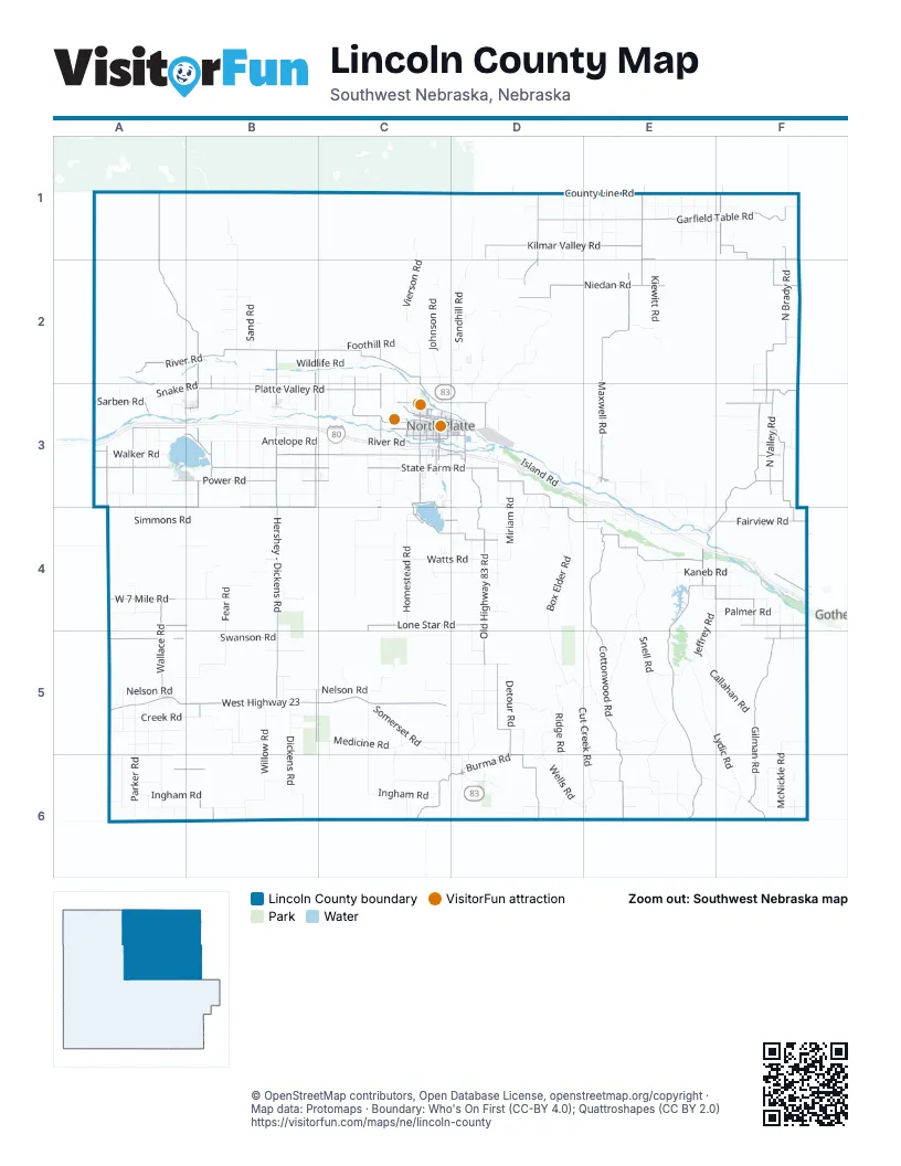
Maps inside Lincoln County
1 map inside, from the street map of Lincoln County down.
Street index of Lincoln County
Each street on the sheet and the grid squares it crosses.
- South Jeffers StreetC3
- West Rodeo Road AvenueC3
- Highway 30F4
- North Jeffers StreetC3
- East 12th StreetC3, D3
- 1st StreetA3, B3, D3
- South Dewey StreetC3
- 12th Street BypassD3
- East Highway 30E3
- West Highway 30E3
- West Highway 23A5, B5, C5
- West State Farm RoadA3, B3, C3
- East State Farm RoadC3, D3, D4, E4
- Newberry AccessD3
- South Buffalo Bill AvenueC3
- South Willow StreetC3, E3
- West Philip AvenueC3
- East Philip AvenueC3, D3
- West 4th StreetC3
- East 4th StreetC3, D3
- North Buffalo Bill AvenueC3
- West Leota StreetC3
- North Bryan AvenueC3, D3
- North Willow StreetC3
- North Poplar StreetC3
- South Bryan AvenueC3
- East Highway 23A5
- East Leota StreetC3
- Newberry Access RoadD3
- North River RoadA2, B2, C2, C3
- North Brady RoadF1, F2, F3, E4, F4
- North Maxwell RoadE1, E2, E3
- Cottonwood RoadE4, E5, E6
- Prairie Trace RoadA1, A2, B2, B3, B5, B6
- Hershey - Dickens RoadB3, B4, B5
- Kilmar Valley RoadD1, E1, F1
- Brady - Moorefield RoadE4, E5, E6
- Garfield Table RoadD1, E1, F1
- Platte Valley RoadB3, C3, F3
- East County Line RoadF1, F2, F3, F4, F5, F6
- North County Line RoadD1, E1, F1
- Old Highway 83 RoadD3, D4, D5
- Gilman RoadF5, F6
- Old Highway 83D5, D6
- Banner RoadE4, F4, F5
- Lone Star RoadA4, B4, C4, D4, F4, C5
- Niedan RoadD2, E2, F2
- West Correction Line RoadA3, B3, A4, B4, C4
- Game Trail RoadB2, B3, B4, B5
- Walker RoadB3, C3
- North Valley RoadF1, F2, F3
- Power RoadA3, B3, C3
- Fort McPherson RoadE4
- Sivedel RoadF3, F4
- South County Line RoadA6, B6, C6, E6, F6
- Fairview RoadC4, D4, F4
- North Wallace RoadA4, A5
- Swanson RoadA5, B5, F5
- Burma RoadA6, B6, D6
- Hays Center RoadC6, D6
- Splinter RoadC2, C3
- Cattle Growers RoadD1, D2
- Front RoadC2, C3
- West 7 Mile RoadA4
- Beveridge RoadA3
- Bubble RoadB2, B3, B6
- West Front StreetC3
- Sarben RoadA3
- Witthuhn RoadF1
- Brown RoadC4, D4
- Sutherland Cemetery RoadA3
- West Swanson RoadA5
- East Walker RoadC3, D3, F3
- North Hershey RoadB2, B3
- West A StreetC3
- Hall RoadF3
- Hall School RoadC3, D3
- South Maloney DriveC4
- North Lake RoadC3, C4
- Tower RoadA3, B3
- South Buffalo RoadC3
- Gilkeson Road SouthA3
- Halligan DriveC3, D3
- Llama RoadD1, D2
- West 9th StreetC3
- Wild Horse RoadF3
- Gilkeson RoadA3
- North Airport RoadD3
- Scouts Rest Ranch RoadC3
- South Oak StreetB3, C3
- South Lakeview BoulevardC3
- East 8th StreetC3, D3
- Burlington BoulevardC3, D3
- North Sheridan AvenueC3
- West B StreetC3
- North Adams AvenueC3
- West Correction Line Road / Road East 40A3
- North Sherman AvenueC3
- Wier RoadA3
- West Lake RoadC3, C4
- South Bare AvenueC3
- West Francis StreetC3
- West 19th StreetC3
- Sail Ridge RoadC4
- South McDonald RoadC3
- North Main StreetD3, E4
- North Oak StreetC3, E3
- East B StreetC3
- North Bicentennial AvenueD3
- East Francis StreetC3
- East Front StreetC3
- South Sherman AvenueC3
- Lincoln AvenueB3
- North Bare AvenueC3
- Nile AvenueD6
- North Lakeview BoulevardC3
- Road 768F4
- South ParkwayC3
- Tennessee StreetD6
- Birdie LaneC4
- South Pine StreetE3
- Wilson AvenueD3
- Roanoke StreetD6
- South Bicentennial AvenueD3
- Road 772F4
- North Pine StreetE3
- Lake StreetD6
- Avenue 375C6
- Road East 40A3
- Hoover RoadC3
- Sand Valley RoadF2
- Avenue 80D1
- Road East 120A3
- Avenue 200F1
- Avenue 140E1
- West Swanson Road / Road 764A5
- Road 393E6
- Road 405F6
- Avenue 40D1
- Somerset RoadC4, C5, C6, D6
- Snell RoadE4, E5, E6
- Medicine RoadA5, B5, C5, D5, F5
- Fear RoadB4, A5, B5
- Homestead RoadC2, C3, C4, C6
- Antelope RoadA3, B3, C3, F3
- Ingham RoadA6, B6, C6, D6, E6
- Sand RoadB2, B3
- Nelson RoadA5, B5, C5, D5
- Goedert - White RoadA3, B3, C3
- Box Elder RoadD4, D5
- Miller School RoadC3, C4
- South River RoadB3, C3
- Wagon Trail RoadC2, C3, C5, C6
- Sandhill RoadD1, D2
- Creek RoadA5, B5, B6
- Lydic RoadE5, F5, F6
- Suburban RoadB2, C2, D2, F2
- Community Center RoadA5, D5
- Parker RoadC3, A4, A5, A6
- Cut Creek RoadD5, E5, E6
- Birdwood RoadB1, B2
- Seifer RoadA3, A5, A6
- Brushy RoadA6, B6, C6, F6
- Willow RoadB5, B6
- Blackwood RoadA3, A4, A5, A6
- Lamont RoadB2, B3, B5
- East Island RoadE4
- Watts RoadC4, D4
- Ridge RoadD5, D6
- Kaneb RoadC4, D4, E4, F4
- Gainwood RoadD5, D6
- Jeffrey RoadE4, F4, E5
- Gibson RoadA6, B6
- Morning View RoadA5, A6
- Smith RoadE1, E3, E4
- Kramer RoadE1, F1
- Wildlife RoadB2, C2, F2
- West Island RoadD3, E3
- McNickle RoadF4, F5, F6
- Callahan RoadE5, F5
- Stewart RoadD2
- Range RoadC2, C3, C5, C6
- Farnam RoadD6, E6, F6
- Wells RoadD6, E6
- West County Line Road / Road 353A4, A5, A6
- Effenbeck RoadE4, E5
- Oregon Trail RoadB3, C3
- Trinity RoadB3, B6
- Johnson RoadC2
- Peckham RoadF4, F5, F6
- South Dickens RoadB5, B6
- North Kiewitt RoadE1, E2
- Vierson RoadC1, C2
- Fletcher RoadE4, E6
- Rolling Hills RoadD2, D3
- Government Pocket RoadE4, E5
- Foothill RoadC2
- Miriam RoadD3, D4
- McPheeters RoadF4, F5, F6
- O'Fallons RoadB2, B3
- Dairy RoadA4, D4
- Auble RoadD1, E1, F1
- Andersen RoadA5
- McCullough RoadE3, E4
- Ash Grove RoadC5, C6
- Walz RoadE1
- Branting RoadD4, D5
- Walking Plow RoadE3, F3
- Willow Creek RoadB2, B3
- Jackson RoadE1, D3, E3
- Padgett RoadA6
- Echo School RoadC5, D5
- Palmer RoadF4
- Detour RoadD5
- Bignell RoadD3, D4
- Twin Lakes RoadD2, D3
- Snake RoadA3, B3
- District 31 School RoadD4
- Simmons RoadA4, B4
- Hansen RoadD4, D5, D6
- King RoadA3, A4
- West Walker RoadA3
- 7 Mile RoadA4, B4
- Plainview RoadD3, D4, E4
- Wahlgren RoadF4
- Hodges RoadD1, D2
- Parkway RoadB2, B3, B4
- Classen RoadE1
- Ehler RoadD1
- Fox RoadE1
- East Pawnee RoadE3, F3, E4
- Cut Across RoadC5, E6
- Scott RoadF4
- Bell Prairie RoadB5, C5, D5
- Miller RoadF2, F3, E4
- Nile RoadD6
- Crane View RoadC2, C3
- Moran RoadD3, D4
- Sugar RoadB4
- Deer Creek RoadE6, F6
- Weems RoadD1, E1
- Grunden RoadE5
- Washboard RoadC2, C3
- Lehman RoadD1, D3
- West 2nd StreetB3, C3, E3
- Mammoth RoadD5, D6
- Koester RoadD5, D6
- Slough RoadB3
- Meadows Lawns RoadC4
- Steck RoadB5, B6
- Morse RoadB5
- Maire RoadA3
- Garfield Cemetary RoadE1
- Steele RoadD3
- Slant RoadE3
- Platte View RoadD3, D4
- Opal Springs RoadD6
- Eshleman RoadD2, D3
- Zwickle RoadD6
- Hidden Lakes RoadD3
- Frederick RoadB4
- Hanson Hill RoadD5, E5
- Shack RoadD3
- North Buffalo RoadC2
- Wild Rose RoadB3
- West County Line Road / Road East Y SouthA3, A4
- Markee Canyon RoadC6
- Maranatha RoadD3, E3, E4
- Meadow Lawns RoadA4, B4
- Long School RoadD3
- Gothenburg Canal RoadF4
- McClellen RoadE5
- Gun Club RoadE3
- Haythorn RoadE3
- Dodge Hill RoadC3
- Fox Creek RoadE6
- West 3rd StreetB3, C3, E3
- Thompson Hill RoadF6
- West 1st StreetB3, C3, E3
- West County RoadA3
- East Kiewitt RoadE2
- West E StreetC3
- East 2nd StreetB3, C3, D3, E3
- Wilson RoadF4, F5
- North Dickens RoadB5
- West 6th StreetC3
- Jenkins RoadB5
- Autogate RoadD2
- Whalgren RoadF1
- Line RoadF4
- Zlomke RoadD4
- North Kiewit RoadE1
- Park RoadA3
- Bailey RoadE4, F4
- Knoll RoadC5
- West 14th StreetC3
- Mitchell RoadD6
- Table RoadF3
- West Pawnee RoadE3
- Hecox RoadF3
Things to do on the Lincoln County map
Places on the map
- Bad-order Repair Tracks
- Bailey Yard
- Birdwood Lake
- Brady
- Brady Rest Area Westbound
- Cody Park
- Eastbound Classification Yard
- Eastbound Departure Yard
- Eastbound Receiving Yard
- Eastbound Run-through
- Hershey
- Iron Eagle Golf Course
- Jeffrey Reservoir
- Lake Maloney
- Lake Maloney Golf Course
- lower Birdwood Creek
- Maxwell
- N Platte R
- NCORPE East
- NCORPE North
- NCORPE South
- North Platte
- North Platte River
- Opplinger Feeders LLC
- Platte State Wildlife Management Area
- Potter's Pasture
- South Platte River
- Spare Yard
- Sutherland
- Sutherland Reservoir
- Sutherland Reservoir State Recreation Area
- Van Yard
- Wallace
- Wellfleet
- Wellfleet Community Lake
- Wellfleet Lake
- Westbound Classification Yard
- Westbound Departure Yard
- Westbound Receiving Yard
- Westbound Run-through
© OpenStreetMap contributors, Open Database License, openstreetmap.org/copyright · Map data: Protomaps · Boundary: Who's On First (CC-BY 4.0); Quattroshapes (CC BY 2.0)















