

Nebraska map
North Platte map
About 22,549 people live here (Census Bureau, 2024 estimate). The sheet's index lists 300 streets; Newberry Access, South Willow Street and Halligan Drive cross the most grid squares. Things to do inside the boundary: Buffalo Bill Ranch State Historical Park.
Open the map (PDF, US Letter)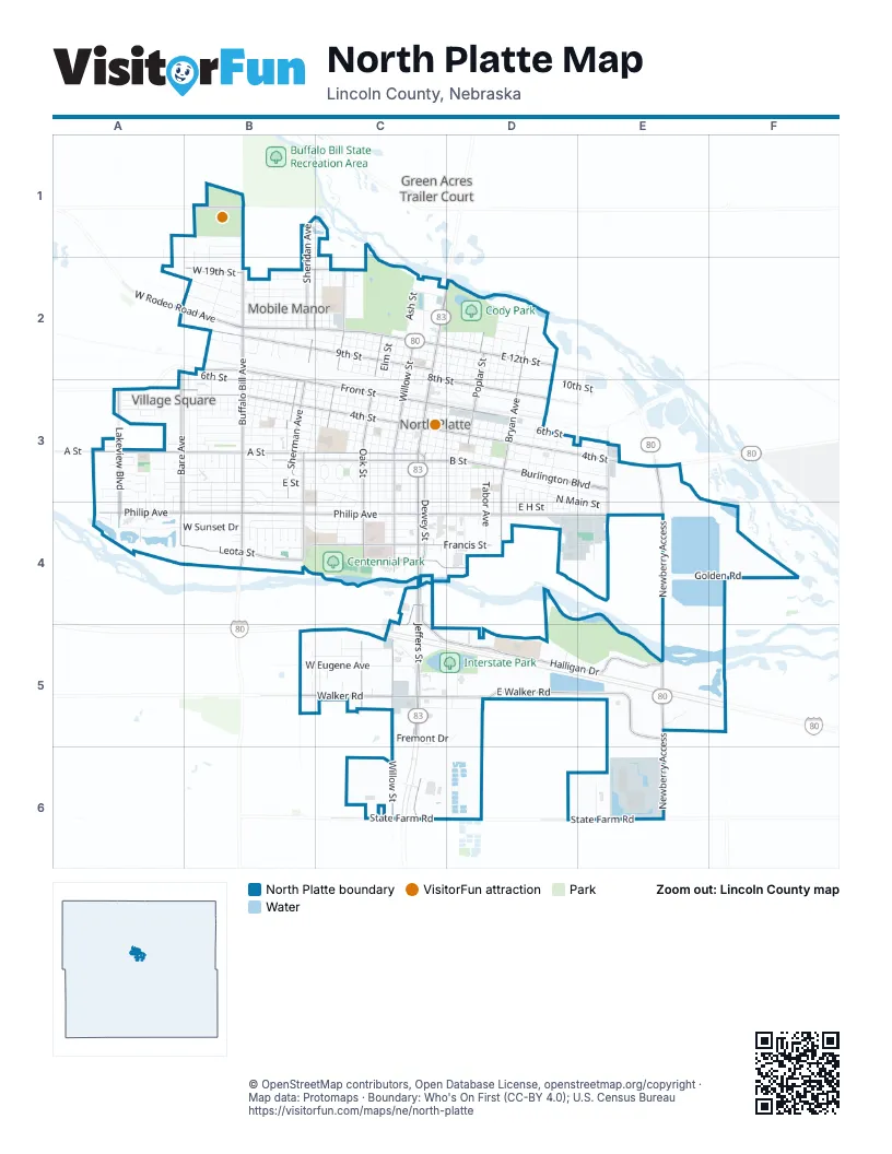
Street index of North Platte
Each street on the sheet and the grid squares it crosses.
- South Jeffers StreetC3, C4, C5
- West Rodeo Road AvenueA2, B2, C2
- North Jeffers StreetC2, D2, C3
- East 12th StreetC2, D2
- South Dewey StreetC3, C4
- 12th Street BypassE3
- Newberry AccessE3, E4, E5, E6
- West Philip AvenueA4, B4, C4
- South Willow StreetC3, C4, C5, C6
- West 4th StreetA3, B3, C3
- East 4th StreetC3, D3, E3
- North Buffalo Bill AvenueB1, B2, B3
- East Philip AvenueC4, D4, E4
- West Leota StreetA4, B4, C4
- South Buffalo Bill AvenueB3, B4
- North Bryan AvenueD2, D3
- North Willow StreetC2, C3
- North Poplar StreetD2, D3
- East State Farm RoadC6, D6, E6
- South Bryan AvenueD3, D4
- West State Farm RoadC6
- East Leota StreetC4, D4
- Newberry Access RoadE5
- West A StreetA3, B3, C3
- Halligan DriveC4, C5, D5, E5
- East Walker RoadC5, D5, E5
- West 9th StreetB2, C2
- West Front StreetB2, B3, C3
- South Oak StreetC3, C4, C5
- South Lakeview BoulevardA3, A4
- Burlington BoulevardD3, E3
- North Sheridan AvenueB1, B2, B3
- West B StreetB3, C3
- North Adams AvenueC2, C3
- East 8th StreetC2, D3
- North Sherman AvenueB2, B3
- South Bare AvenueA3, A4
- Walker RoadC5
- West Francis StreetB4, C4
- South McDonald RoadB3, B4
- West 19th StreetB2, C2
- North Oak StreetC2, C3
- East B StreetC3, D3
- East Francis StreetC4, D4
- East Front StreetC3, D3
- South Sherman AvenueB3
- North Bare AvenueA3
- Scouts Rest Ranch RoadB1
- North Bicentennial AvenueE3
- South ParkwayC6
- South Bicentennial AvenueE3, E4
- North Lakeview BoulevardA3
- West 2nd StreetA3, B3, C3
- West E StreetA3, B3, C3
- West 6th StreetA2, B2, B3, C3
- West 3rd StreetA3, B3, C3
- West 14th StreetB2, C2
- West 1st StreetB3, C3
- East D StreetC3, D3, E3
- West C StreetA3, B3, C3
- East E StreetC3, D3, E3, E4
- East 2nd StreetC3, D3, E3
- West Sunset DriveA4, B4
- West 5th StreetB3, C3
- West 16th StreetA2, B2, C2
- East 5th StreetC3, D3, E3
- West Cedarberry RoadB3, C3, B4, C4
- East 6th StreetC3, D3, E3
- West William AvenueB4, C4
- West D StreetA3, B3, C3
- North Ash StreetC2, C3
- North Sycamore StreetC2, C3
- West Eugene AvenueB5, C5
- West 10th StreetB2, C2
- South Carr AvenueB3, B4
- West 13th StreetB2, C2
- West 18th StreetB2, C2
- North Madison AvenueC1, C2, B3, C3
- North Hayes AvenueB2, B3
- East 10th StreetC2, D2, D3
- East H StreetC4, D4
- West 8th StreetB2, C2
- West Birchwood RoadB3
- North Emory AvenueB2, B3
- West F StreetA3, B3, C3
- North Dewey StreetC2, D2, C3
- Golden RoadE4, F4
- North Walnut StreetD2, D3
- East 3rd StreetC3, D3
- North Bailey AvenueD2, C3
- West 11th StreetC2
- South Cottonwood StreetD3, D4
- South Ash StreetC3, C4
- East G StreetC3, D3
- North Vine StreetC2, C3
- North Chestnut StreetD2, C3, D3
- North Cottonwood StreetD2, D3
- North Elm StreetC2, C3
- North Maple StreetC2, C3
- West 7th StreetC2, C3
- West 17th StreetB2, C2
- North Silber AvenueD2, D3
- South Tabor AvenueD3, D4
- North Carr AvenueB2, B3
- East 9th StreetC2, D2, D3
- East 7th StreetC3, D3
- East C StreetC3, D3
- North Tabor AvenueD2, D3
- North Taft AvenueD2, D3
- North Miles AvenueB2, B3
- North Mills AvenueB2, B3
- East 11th StreetC2, D2
- South Union AvenueC3, C4
- North Jackson AvenueC2, B3
- South Poplar StreetD3, D4
- North Elder AvenueB2, B3
- North Custer AvenueB2, B3
- West Reid AvenueC4
- North Dodge AvenueB1, A2, B2
- Alpha StreetB3, C3
- East 13th StreetC2, D2
- East 14th StreetD2
- South Bailey AvenueC3, C4
- West 15th StreetB2
- South Elm StreetC3, C4
- South Maple StreetC3, C4
- Dixie AvenueA3, A4
- South Chestnut StreetC3, C4
- Charlie Evans DriveB1
- North Cody Park RoadD2
- North Franklin AvenueB2
- West Cedarberry LaneB4
- South Sycamore StreetC3, C4
- North Roosevelt AvenueD2, D3
- South Walnut StreetD3, D4
- South Vine StreetC3, C4
- Grande AvenueB3, C3, C4
- East F StreetC3, D3
- South Baytree AvenueB3, B4
- West 20th StreetA2, B2
- North Washington AvenueC2, C3
- Sioux Meadows DriveC5, D5
- North Main StreetD3, D4, E4
- South Silber AvenueD3, D4
- West Russian Olive RoadC5
- Eastman AvenueD3
- Silber AvenueD3
- Holiday Frontage RoadC5
- North Eastman AvenueD2, D3
- North Garfield AvenueC3
- North Grant AvenueC3
- North Jefferson AvenueC3
- North McCabe AvenueD3
- South Jefferson AvenueB3, C3
- West Hackberry RoadB5, C5
- West 21st StreetB1
- Hidden Lakes RoadF5
- Centennial Park RoadC4
- South Elder AvenueB3
- Prospect DriveE4
- West Wright AvenueB3
- Industrial AvenueE4
- West Pawnee AvenueB3
- North Welch AvenueD3
- South Gilman AvenueB3, B4
- Sequoia DriveA3
- South Cody Park RoadD2
- North Pacific StreetB2, B3
- South Allen AvenueB3
- Sugarberry RoadA3
- East 16th StreetD2
- South Reynolds AvenueC3
- Railroad StreetD3
- North Augusta AvenueC2
- North Jessie AvenueC2
- North Lincoln AvenueC3
- South McCabe AvenueD3, D4
- North Curtis AvenueC2
- North Lake DriveD5
- South Taft AvenueD3, D4
- Main StreetD4, E4
- Iron Eagle CourtD5, E5
- West Anna AvenueB3
- South Welch AvenueD3, D4
- East Fremont DriveC5, D5
- Twin River RoadE6
- South Eastman AvenueD3, D4
- Carousel RoadC2, D2
- West 22nd StreetB1
- West Railroad StreetB2
- Spruce StreetC3, C4
- East A StreetC3, D3
- West G StreetC3
- Iron Eagle DriveD5
- West Park Ridge RoadA3
- Kiddie Pond RoadD2
- Ioke StreetC5
- Anna AvenueB3
- South Michael AvenueB3
- Short StreetB3, C3
- South Belmont AvenueD3, D4
- East Commerce DriveE5
- Beverly BoulevardB3
- Bretwood CourtA4
- Washington AvenueC2
- South Emory AvenueB4
- Prairie Ridge RoadA3
- Darlene RoadB1, C1
- James AvenueC3
- North Belmont AvenueD3
- North Cody AvenueB2
- Riverside DriveC4
- South York AvenueD3, D4
- West Cody Park RoadD2
- South Sheridan AvenueB3
- East 15th StreetD2
- West Fremont DriveC5
- South Griffith AvenueD3, D4
- South Lincoln AvenueC3
- William CourtB4
- Dillon CourtB3, B4
- Bel Aire RoadC3
- East Sunrise DriveC6
- Myrtle StreetB3
- South Madison AvenueB3
- Iron Eagle LaneE5
- South Meyer AvenueD3, D4
- McDonald AvenueC3
- Hahn AvenueC4
- West Park DriveA3
- Autumn Park DriveD4
- East Circle DriveC3
- West Circle DriveC3
- Boyd AvenueC3
- West 18th AvenueB2
- Lynn CourtC5
- Red Fox LaneB1, C1
- 1st StreetD3, D4
- Cornhusker CircleB4
- Dent CourtB4
- South Hayes AvenueB3
- Janice CourtA3
- Prospect LaneE4
- South Custer AvenueB3
- Stewart AvenueA3, A4
- Sweetwood DriveA3
- North Allen StreetB2, B3
- South Ames AvenueB3
- South Church StreetB3
- North Rodeo AvenueB1, B2
- South Circle DriveC3
- Appaloosa DriveC5
- Leo Schearer AvenueD3
- Edna's CourtA3
- Miles CourtB4
- North Allen AvenueB3
- Kristen CourtB4
- North Park DriveA3
- Sheridan CourtB4
- Hasenauer CourtC5
- Sherman CourtB4
- Tanner CourtA4
- Meadow CourtB5
- 4th StreetD3, D4
- West Redwood DriveA3
- Ruth StreetB3
- Clearwater CourtA3, A4
- Tyler CourtA4
- South Grant AvenueC3
- Aspen DriveA3
- South River RoadC5
- Atlantic StreetB3
- Sugarberry CourtA3
- West Parkland CircleA3
- West Parkland CourtA3
- Teal LaneA4
- Gail Wicks StreetC2
- South Regency LaneB3
- Willowwind RoadC5
- Maplewood DriveA3
- Memorial Road 2D3
- South Garfield AvenueC3
- Memorial Road 3D3
- 7th StreetE4
- 8th StreetE4
- 9th StreetE4
- Platte Oasis ParkwayC4
- War Bonnet RoadD5
- West Timothy CourtA3
- Bridle LaneC2
- McNeel LaneC4
- Memorial Road 4D3
- 2nd StreetD3, D4
- Bridle DriveC2
- Sweetwood CourtA3
- Teal CourtA4
- Memorial Road 1D3
- Custer CourtB4
- Jackson LaneC2
- South Rose Park DriveB3
Things to do on the North Platte map
Places on the map
- Adams Bank & Trust
- Adams Middle School
- Advance Auto Parts
- Americas Best Value Inn
- Applebee's
- Armory Park
- Bill Wood Field
- Buffalo Bill Ranch State Historical Park
- Burger King
- Calvary Baptist Church
- Carrol's Towing & Repair
- Centennial Park
- Cody Elementary School
- Cody Park
- Cody Park Softball Complex
- Cody Park Swimming Pool
- Dollar Tree
- Dunkin'
- Eisenhower Elementary School
- Eisenhower Park
- Fat Dogs
- Field A
- Flying J Travel Center
- Great Plains Health
- Happy Hound Retreat
- Interstate Park
- Iron Eagle Golf Course
- Love's Travel Stop
- Madison Middle School
- McDonald Belton Campus Library
- Memorial Park
- Menard's
- North Platte Cemetery
- North Platte High School
- North Platte Post Office
- North Platte Public Library
- River’s Edge Golf Club
- Van Yard
- Walmart Supercenter
- Westfield Shopping Center
Next to North Platte
- Green Acres Trailer Court
© OpenStreetMap contributors, Open Database License, openstreetmap.org/copyright · Map data: Protomaps · Boundary: Who's On First (CC-BY 4.0); U.S. Census Bureau















