

Nebraska road map
Lincoln Highway Scenic and Historic Byway map
The Lincoln Highway Scenic and Historic Byway has been a National Scenic Byway since 2021, named for its historic qualities: about 410 miles in Nebraska. It meets 21 highways, among them I-80, US 26 and US 30. Towns along it: Grand Island, Kearney and Fremont.
Open the map (PDF, US Letter)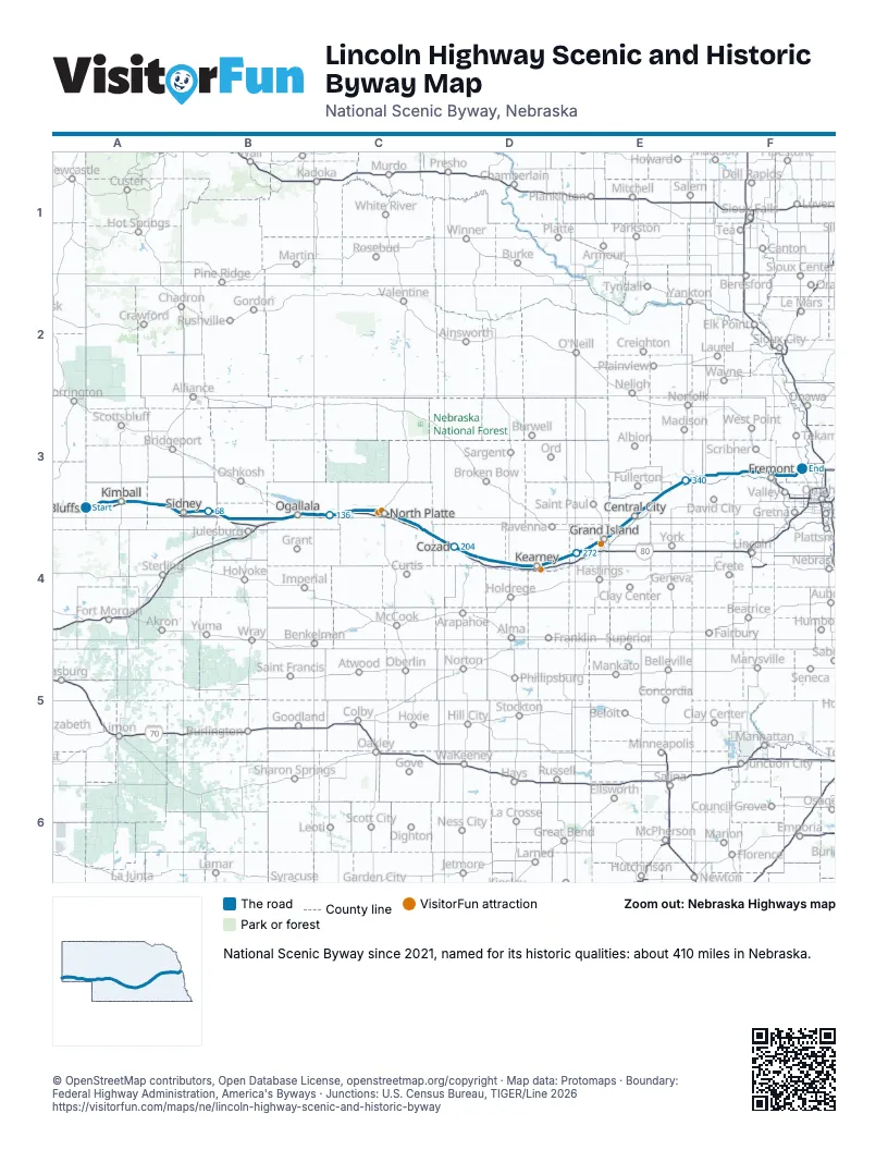
Highways it meets
Each highway it meets and the grid squares where they meet.
- US 30A3
- I-80A3
- NE 19A3
- US 385B3
- NE 27B4
- US 138B4
- US 26B3
- NE 25C3
- NE 47C4
- NE 21D4
- US 283D4
- US 183D4
- NE 11E4
- NE 14E3
- NE 92E3
- NE 39E3
- US 81E3
- NE 15F3
- NE 79F3
- US 77F3
- US 275F3
Towns along the Lincoln Highway Scenic and Historic Byway
In mile order, with the grid square of each.
- Kimballmile 20, A3
- Dixmile 26, A3
- Pottermile 35, A3
- Sidneymile 53, A3
- Sunolmile 64, B3
- Lodgepolemile 71, B3
- Chappellmile 81, B4
- Brulemile 111, B4
- Ogallalamile 118, B3
- Roscoemile 124, B3
- Paxtonmile 136, C3
- Sutherlandmile 148, C3
- Hersheymile 155, C3
- North Plattemile 166, C3
- Maxwellmile 172, C4
- Bradymile 181, C4
- Gothenburgmile 193, C4
- Willow Islandmile 198, D4
- Cozadmile 204, D4
- Lexingtonmile 217, D4
- Overtonmile 229, D4
- Elm Creekmile 237, D4
- Odessamile 244, D4
- Kearneymile 251, D4
- Gibbonmile 260, D4
- Sheltonmile 267, D4
- Wood Rivermile 273, E4
- Aldamile 282, E4
- Grand Islandmile 285, E4
- Chapmanmile 294, E4
- Central Citymile 303, E4
- Clarksmile 315, E3
- Silver Creekmile 326, E3
- Duncanmile 337, E3
- Columbusmile 343, E3
- Schuylermile 360, F3
- Rogersmile 368, F3
- North Bendmile 375, F3
- Fremontmile 390, F3
- Arlingtonmile 398, F3
Things to do on the Lincoln Highway Scenic and Historic Byway map
© OpenStreetMap contributors, Open Database License, openstreetmap.org/copyright · Map data: Protomaps · Boundary: Federal Highway Administration, America's Byways · Junctions: U.S. Census Bureau, TIGER/Line 2026















