

Nebraska map
Scotts Bluff County map
About 35,734 people live here (Census Bureau, 2024 estimate). The sheet's index lists 300 streets; Highway 26, Highway 92 and County Road H cross the most grid squares. Things to do inside the boundary: Scotts Bluff Area and Scotts Bluff National Monument.
Open the map (PDF, US Letter)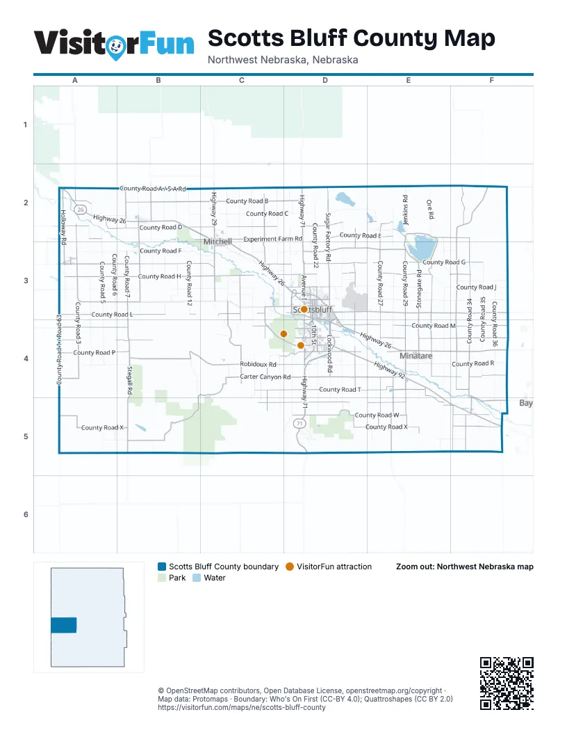
Maps inside Scotts Bluff County
1 map inside, from the street map of Scotts Bluff County down.
Street index of Scotts Bluff County
Each street on the sheet and the grid squares it crosses.
- Highway 26A2, B2, C2, C3, D3, D4, E4, F4
- Highway 71D2, D3, D4, D5
- Broadway StreetC2
- East Webster StreetB2
- Webster StreetB2
- West Webster StreetB2
- US Highway 26F4
- Heartland ExpresswayD4, E4
- Highway 92A3, B3, C3, D3, D4, E4, E5, F5
- Old Oregon TrailC3, C4, D4
- 10th StreetC3, D3, D4, E4
- Avenue ID3, D4
- Highway 29C2
- Five Rocks RoadD4
- 21st AvenueD3, D4
- South Beltline Highway EastD3, D4
- 5th AvenueD3, D4, E4
- South Beltline Highway WestD3
- Avenue BD3
- U StreetD4
- BroadwayD3
- West Overland DriveD3
- West 42nd StreetD3
- Country Club RoadD4
- East 20th StreetD3
- 19th AvenueC2, C3, D3
- East Overland DriveD3
- West 20th StreetD3
- West 27th StreetD3
- East 27th StreetD3
- M StreetD4
- Kimball AvenueD4
- 20th StreetC2, D3, D4
- West N StreetA3
- East N StreetA3
- State Highway 92A3
- 27th StreetD3
- County Road HA3, B3, C3, D3, E3, F3
- County Road DA2, B2, C2, D2, E2
- County Road GB3, C3, D3, E3, F3
- County Road 34F2, F3, F4, F5
- County Road MA4, B4, C4, D4, E4, F4
- Carter Canyon RoadB4, C4, D4, B5
- County Road UE4, F4, C5, D5, E5, F5
- County Road BA2, B2, C2, D2
- County Road LA3, B3, C3, F3
- Robidoux RoadB4, C4, D4
- County Road TC4, D4, E4, F4
- County Road NA4, B4, D4, E4, F4
- County Road A / S-A RoadA2, B2, C2, F2
- County Road WA5, D5, E5, F5
- County Road XA5, B5, D5, E5, F5
- County Road 27E2, E3, E4, E5
- County Road PA4, B4, C4, D4, E4
- County Road SA4, D4, E4, F4
- Stonegate RoadE2, E3, E4
- Stegall RoadB3, B4, B5
- County Road 31E2, E3, E4
- County Road 29E3, E4, E5
- County Road 3A2, A3, A4, A5
- North Highland RoadF2, F3
- County Road EA2, B2, C2, D2, E2, F2
- County Road 25D2, D3, D4, D5
- County Road 33F3, F4, F5
- Highland RoadD3, E3, F3
- Sugar Factory RoadD2, D3
- Lake Minatare RoadD3, E3
- County Road 7B2, B3
- Wright's Gap RoadE4, E5
- Experiment Farm RoadC2, D2
- South Morrill RoadB2, B3
- County Road 1 / Road 63A2, A3, A4, A5
- Rifle Sight Pass RoadC3, C4
- County Road 18C2, C3, C4, C5
- Holloway RoadA2, A3
- County Road 16C3, C4
- East Lyman RoadA3, B3
- Mitchell South RoadC3
- Sunflower Oil RoadC2, C3
- Lockwood RoadD4
- 3rd AvenueB2, A3, D3, E4
- Liberty Oil RoadB2
- 7th StreetD4, E4
- D StreetD4
- Highway L79EE4
- 2nd AvenueB2, D3, D4, E4
- Sandberg RoadD4
- 11th AvenueC2, A3, C3, D3
- 9th AvenueC2, A3, D3, D4
- 4th StreetD4, E4, F5
- Main StreetE4, F5
- East 42nd StreetD3
- East 17th StreetD3
- 10th AvenueC2, A3, C3, D3
- York Road / County Road AF2
- West Railway StreetD3
- Stable Club RoadD4
- County RoadB2, E4
- West 24th StreetD3
- Pacific BoulevardD4
- Airport RoadD3
- Old Highway 92D3
- Terry BoulevardD4
- West 33rd StreetD3
- C AvenueE4
- Nichols AvenueA2
- Morrison RoadD4
- County Road AA2, F2
- Mobile AvenueD4
- Road 120F3
- Road 106F5
- Wrights Gap RoadE5
- 10th Street ConnectorD4
- S-3 RoadA2
- Road 54A2
- Henry RoadA2
- Road 56A2
- County Road JA3, B3, C3, D3, E3, F3
- County Road FA3, B3, C3, D3, E3, F3
- County Road RA4, B4, D4, E4, F4
- County Road CA2, B2, C2, D2, E2
- County Road 19C2, C3, C4, C5
- County Road KD3, E3, F3
- County Road 5A2, A3, A4, A5
- County Road 20D2, D3, D4, D5
- County Road 24D2, D3, D4, D5
- County Road 22D2, D3, D4, D5
- County Road 26E2, D3, E3, E4, E5
- County Road 17C2, C3, C4, B5, C5
- County Road 36F3, F4, F5
- County Road 35F3, F4, F5
- County Road 32E2, E3, E4, E5
- County Road 6A3, A4, A5
- County Road 28E2, E3, E4
- County Road 12B2, B3
- County Road 4A2, A3, A4
- Road 71 / County Road 38F3, F4, F5
- County Road 15C2, C3, C4
- County Road 13C2, C3
- County Road 10B2, B3
- County Road 11B2, B3
- Cook Oil RoadC2, C3
- County Road Z / County Road 44A5, B5, E5, F5
- County Road 9B2, B3, A5, B5
- County Road YA5, B5, E5, F5
- Spring Creek RoadC2, C3
- Ore RoadE2
- Jenkins RoadE2
- Summit Ranch RoadB4
- County Road 8B2, B3
- County Road 2A3
- Finch RoadF3
- 12th AvenueC2, A3, C3, D3
- Wildcat DriveD5
- 13th StreetC2, C3, D4
- 17th StreetC2, D4
- 4th AvenueC2, A3, D3, E4
- Haig RoadC3
- County Road 23D4, D5
- Sea Gull RoadE2
- 1st AvenueB2, D3, E4
- 5th StreetD4, E4, F5
- Buffalo RoadC4, C5
- Old Stage Hill RoadD5
- Avenue DD3
- Owl RoadD3, D4
- Highline Canal RoadE2
- 18th StreetC2, D4
- GFL RoadC4
- County Road 30E4, E5
- Skyport DriveD3
- Peaceful Valley RoadD5
- Center AvenueB2, C2, C3
- 12th StreetC3, D4
- 2nd StreetB2, D4, E4, F5
- Avenue CD3
- Avenue GD3
- 14th StreetC2, D4
- 13th AvenueC2, C3, D3
- 19th StreetC2, D4
- 6th StreetD4, E4, F5
- 17th AvenueC2, C3, D3
- 16th AvenueC2, C3, D3
- N StreetD4
- 8th AvenueC2, A3, D3
- Avenue FD3
- Pinecone DriveD5
- East 15th StreetD3
- 3rd StreetB2, D4, E4, F5
- O StreetD4
- Diagonal RoadF5
- Derringer RoadC4
- 11th StreetC3, D3, D4
- Cherry LaneC3
- River RoadC3
- Ponderosa DriveD5
- Avenue AD3
- S StreetD4
- Avenue HD3
- P StreetD4
- Railway StreetC3, D3
- K StreetD4
- West Charles StreetB2
- 21st StreetC2, D3, D4
- 9th StreetD4, E4
- 14th AvenueC2, C3, D3
- Highway 26 Frontage RoadC3
- Q StreetD4
- 16th StreetC2, D4
- 6th AvenueC2, D3
- Avenue ED3
- BN RoadE4
- Panorama DriveD3
- Leisure LaneD2, D3
- Lagoon RoadA3
- Eagle RoadD3
- Swedell Oil RoadC2
- Avenue OD3
- Sparrow RoadE3
- Unnamed RoadE5
- Kihlthau RoadC4
- Lowline Ditch RoadE3
- R StreetD4
- Thrush RoadC3
- West 18th StreetD3
- Crow RoadD4
- East 19th StreetD3
- Schleicher RoadC5, D5
- Avenue ND3
- 8th StreetD4, E4
- Hardin RoadC4
- West 36th StreetD3
- Avenue KD3
- Hunt Dairy RoadC3
- East 18th StreetD3
- East 12th StreetD3
- West 26th StreetD3
- T StreetD4
- 7th AvenueD3
- East Charles StreetB2
- West 19th StreetD3
- Circle DriveD3
- East 7th StreetD3
- East 38th StreetD3
- A StreetD4
- West 17th StreetD3
- East 28th StreetD3
- Railroad StreetA3, E4
- East 9th StreetD3
- Silverman LaneA2
- West 15th StreetD3
- Rundell RoadD4
- West 31st StreetD3
- Avenue MD3
- Deer LaneE4
- County Road 14C3
- North Railroad StreetB2
- Prairie TrailD3
- J StreetD4
- 18th AvenueC2, C3, D3
- Service Road TrailD5
- Riverside Park Road CD3
- Jeffers AvenueA3
- Hawk RoadC3
- East 35th StreetD3
- Main RoadE3
- West 22nd StreetD3
- 15th StreetD4
- West 14th StreetD3
- Hillcrest DriveD3
- Meadowlark DriveD3
- West 25th StreetD3
- Berggren RoadC3
- Avenue LD3
- Daggert RoadC3, C4
- South Frontage RoadD3
- Engleman LaneC3
- West 23rd StreetD3
- West 16th StreetD3
- Immigrant Trail RoadD3, D4
- Floral StreetD4
- Bonanza StreetD4
- Premier LaneD3
- 15th AvenueD3
- Ridgeway DriveC3
- Winter Creek DriveD3
- 23rd StreetC2, D3
- Enterprise DriveD3
- Railway AvenueE4
- South 14th StreetD4
- East 11th StreetD3
- East 14th StreetD3
- East 22nd StreetD3
- Road 32A4
- Sauer RoadC4
- West 21st StreetD3
- Woodley Park RoadD4
- Avenue VD3
- Loseke RoadC3, D3
- West 35th StreetD3
Things to do on the Scotts Bluff County map
Places on the map
- Bead Mountain PRBE
- Carpenter Park
- Carter Canyon PRBE
- Cedar Canyon State Wildlife Management Area
- Cochran Lake
- Diamond Bit PRBE
- Fairview Cemetery
- Frank Reservoir
- Gering
- Gering Landfill
- Gering Valley Reservoir A
- Gering Valley Reservoir C
- Henry
- Lake Alice
- Lake Alice Number Two
- Lake Minatare
- Lyman
- McGrew
- Melbeta
- Minatare
- Minatare Lake State Recreation Area
- Mitchell
- Montz Ranch PRBE
- Monument Shadows Golf
- Morrill
- Murray Lake
- North Platte National Wildlife Refuge
- North Platte River
- Riverside Park
- Scenic Knolls Golf Course
- Scotts Bluff National Monument
- Scottsbluff
- Silver Spur Feeders
- South Mitchell PRBE
- Spotted Tail - BOWEN PRBE
- Spotted Tail - TOTTENHOFF PRBE
- Spotted Tail PRBE
- Sunrise Beach
- Terrytown
- Winters Creek Lake
Next to Scotts Bluff County
- Bayard
© OpenStreetMap contributors, Open Database License, openstreetmap.org/copyright · Map data: Protomaps · Boundary: Who's On First (CC-BY 4.0); Quattroshapes (CC BY 2.0)















