

Nebraska map
Scottsbluff map
About 14,323 people live here (Census Bureau, 2024 estimate). The sheet's index lists 204 streets; Highway 26, 12th Avenue and Avenue I cross the most grid squares. Also on it: Riverside Park, Fairview Cemetery and Regional West Medical Center.
Open the map (PDF, US Letter)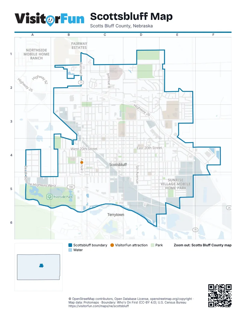
Street index of Scottsbluff
Each street on the sheet and the grid squares it crosses.
- Avenue IB1, B2, B3, B4, B5, B6
- Cedar View DriveB1
- West 42nd StreetB1, C1
- Avenue BC1, C2, C3, C4, C5
- Avenue DC1, C2, C3, C4, C5
- Avenue GC1, C2, C3, C4, C5
- East 42nd StreetC1, D1, E1
- Monument CircleC1
- Rugger DriveC1, C2
- Sandstone CircleC1
- Sandstone DriveC1
- 5th AvenueD1, D2, D3, D4, D5, D6
- County Road 22D1
- Fox Run LaneD1, E1, D2
- Hilltop PlaceD1, D2, E2
- 12th AvenueE1, D2, E2, D3, E3, E4, E5
- Ferdinand PlazaB2
- Highway 26B2, C2, D2, D3, E3, E4, F4, F5
- West 33rd StreetB2, C2
- West 36th StreetB2, C2
- 2nd AvenueC2, D2, D3, D4, D5
- Aspen DriveC2
- Avenue EC2, C3, C4, C5
- Avenue FC2, C3, C4, C5
- Berit CourtC2
- Bluestem DriveC2
- East 35th StreetC2, D2
- East 36th StreetC2
- East 37th StreetC2, D2
- East 38th StreetC2, D2, E2
- Five Oaks DriveC2
- Hillcrest DriveC2, D2
- Lincoln CourtC2
- Maple DriveC2
- Mulberry DriveC2
- Northwood CourtC2
- Ross AvenueC2
- Sagebrush DriveC2
- Sandra CourtC2
- Sitzman CourtC2
- Stoney Creek DriveC2
- West 32nd StreetC2
- West 35th StreetC2
- West 37th StreetC2
- West 38th StreetC2
- West 39th StreetC2
- West 40th StreetC2
- 8th AvenueD2, D3, D4, D5
- Blue Bell CourtD2
- Brentwood CourtD2, D3
- Cary CourtD2
- Evergreen DriveD2, E2
- Juniper DriveD2, E2
- Larkspur CourtD2, E2
- Primrose CourtD2
- Primrose DriveD2, E2, D3
- Regency CourtD2
- Rosedale DriveD2
- Skyline DriveD2
- Spruce DriveD2
- Sunrise DriveD2
- Valley View DriveD2, D3
- 16th AvenueE2, E4, E5
- 17th AvenueE2, E3, E4, E5
- 18th AvenueE2, E3
- 19th AvenueE2, E3, E4, E5
- 21st AvenueE2, E3, E4, E5
- Arella LaneE2
- Cherokee DriveE2
- East 32nd StreetE2
- East 33rd StreetE2
- East 34th StreetE2
- Idlewylde DriveE2
- Larkspur DriveE2
- Lilac DriveE2
- Peony CourtE2
- Verbena DriveE2
- Verbena PlaceE2
- Avenue HB3, C3, B4, B5, C5
- Avenue KB3, B4, B5
- Avenue LB3, B4, B5
- Avenue MB3, B4, B5
- Avenue OB3, B4, B5
- Canal StreetB3, C3
- Dineen AvenueB3
- Don DriveB3, B4
- West 23rd StreetB3, C3
- West 24th StreetB3, C3
- West 25th StreetB3, C3
- West 26th StreetB3, C3
- West 27th StreetB3, C3
- West 28th StreetB3
- West 29th StreetB3, C3
- West 31st StreetB3, C3
- West Railway StreetB3, B4, C4, C5
- 1st AvenueC3, C4, C5, D5
- 23rd StreetC3
- 27th StreetC3
- 29th StreetC3, D3
- Avenue AC3, C4, C5
- Avenue CC3, C4, C5
- BroadwayC3, C4, C5
- East 23rd StreetC3, D3
- East 27th StreetC3, D3, E3
- 3rd AvenueD3, D4, D5
- 4th AvenueD3, D4, D5
- 6th AvenueD3, D4, D5
- 7th AvenueD3, D4, D5
- Circle DriveD3, D4, E4
- East 24th StreetD3
- East 26th StreetD3
- East 28th StreetD3, E3
- Park Lane RoadD3
- South Frontage RoadD3, E3, E4
- Talisman DriveD3
- Winter Creek DriveD3, E3
- 13th AvenueE3, E4, E5
- 14th AvenueE3, E4, E5
- Addison AvenueE3
- Cheyenne DriveE3
- College ParkE3
- East 29th StreetE3
- East 30th StreetE3
- East 31st StreetE3
- Erwin StreetE3
- North Frontage RoadE3, E4
- Avenue VA4, A5
- Avenue XA4, A5
- Avenue ZA4, A5
- West 15th StreetA4, B4, C4
- West 17th StreetA4, B4, C4
- West 18th StreetA4, B4, C4
- West 19th StreetA4, B4, C4
- West 20th StreetA4, B4, C4
- Avenue JB4, B5
- Avenue NB4, B5
- Avenue PB4, B5
- Bluff StreetB4, C4
- Char AvenueB4
- Laucomer DriveB4
- Mill Drive NorthB4
- Mill Drive WestB4, C4
- Park StreetB4, C4
- West 14th StreetB4, C4, B5, C5
- West 16th StreetB4, C4
- West 22nd StreetB4, C4
- 20th StreetC4
- 21st StreetC4
- 22nd StreetC4
- Bryant AvenueC4, C5
- Cowen DriveC4
- East 15th StreetC4, D4, E4
- East 16th StreetC4, D4
- East 17th StreetC4, D4, E4
- East 18th StreetC4, D4, E4
- East 19th StreetC4, D4, E4
- East 20th StreetC4, D4, E4, F4
- East 21st StreetC4, D4
- East 22nd StreetC4, D4
- Runza Drive-ThroughC4
- West 21st StreetC4
- 10th AvenueD4, D5
- 11th AvenueD4, D5
- 9th AvenueD4, D5, D6
- Platte Valley DriveD4, E4
- Residency DriveD4
- 15th AvenueE4, E5
- Cross RoadE4
- Delta DriveE4, F4
- East 20th PlaceE4
- Portal PlaceE4
- 25th AvenueF4
- South Beltline Highway WestA5, B5, C5
- West Overland DriveA5, B5, C5
- 11th StreetB5
- Avenue QB5
- Avenue RB5
- Grey StreetB5, C5
- Riverside DriveB5
- Riverside Park Road CB5
- Schmid DriveB5
- West 11th StreetB5
- West 7th StreetB5
- West 8th StreetB5, C5
- 10th StreetC5
- East 12th StreetC5, D5, E5
- East 14th StreetC5, D5, E5
- East 9th StreetC5, D5, E5
- East Overland DriveC5, D5, E5, F5
- South Beltline Highway EastC5, D5, D6, E6
- West 12th StreetC5
- East 10th StreetD5, E5
- East 11th StreetD5, E5
- East 7th StreetD5, E5
- East 8th StreetD5, E5
- Railway StreetD5
- Arlene LaneE5
- Erin LaneE5
- Jerry DriveE5
- Lee Ann LaneE5
- Marcus DriveE5
- Mary LaneE5
- Highland RoadF5
- 2nd StreetD6, E6
Places on the map
- 23 Club Complex
- A-1 Self Storage
- All Star Customs
- Arby's
- Arthur's Pizza
- Auto Works Service & Repair
- AutoZone
- Babe Ruth Baseball Field
- Backaracks Steakhouse & Grill
- Bearcat Stadium
- Bellos
- Best Plumbing Heating and Cooling LLC
- Big Red Storage II
- Black Rifle Coffee Company
- Bluff View Church of Christ
- Bluffs Animal Hospital
- Bluffs Middle School
- Bridgman Funeral Home and Cremation Service
- Bumper to Bumper Body & Paint
- Candlelight Inn
- Capri Motel
- Cleavland Athletic Field
- Fairview Cemetery
- Historic Saddle Club
- Jaycee Park
- Menards
- Northwood Park
- Regional West Medical Center
- Regional West Medical Center Resource Library
- Riverside Campground
- Riverside Discovery Center
- Riverside Park
- Scottsbluff Public Library
- Scottsbluff Senior High School
- Stor-AUL Storage
- The Village
- Uptown Scottsbluff (formerly Monument Mall)
- Walmart Supercenter
- Western Nebraska Community College Library
- Western Nebraska Veterans Home Library
Next to Scottsbluff
- Fairway Estates
- Northside Mobile Home Ranch
- Terrytown
© OpenStreetMap contributors, Open Database License, openstreetmap.org/copyright · Map data: Protomaps · Boundary: Who's On First (CC-BY 4.0); U.S. Census Bureau















