

New Hampshire map
Coos County map
About 31,094 people live here (Census Bureau, 2024 estimate). The sheet's index lists 300 streets; Main Street, Daniel Webster Highway and Park Street cross the most grid squares. Things to do inside the boundary: Mount Washington Auto Road, Mount Washington Cog Railway and Androscoggin Wayside Park.
Open the map (PDF, US Letter)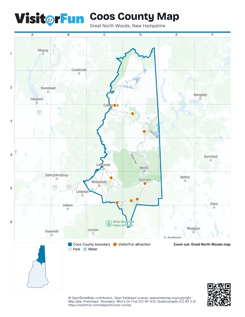
Street index of Coos County
Each street on the sheet and the grid squares it crosses.
- Daniel Webster HighwayD1, C2, D2, C3, C4, C5
- Main StreetC2, D2, C3, D3, C4, D4, C5, D5
- Berlin RoadD3, D4
- White Mountain RoadD5, D6
- Presidential HighwayC5, D5
- Gorham Hill RoadD5
- N.H. Route 26D3
- Mohawk RoadC3, D3
- Upton RoadD3, E3, E4
- Prospect StreetC4, D4, C5
- Owls Head HighwayC5
- US Route 3 NorthC5
- Milan RoadD4
- Washington StreetC2, D4, D5
- US Route 3C3
- Lancaster RoadC4, C5, D5
- Colebrook RoadD3
- Trooper Leslie G Lord HighwayC2
- State Route 115C5
- Portland StreetC4, D4, C5
- Riverside DriveC4, D4, C5
- Bridge StreetC2, C3, C4, D4
- Twin Mountain RoadC5
- US Route 3 SouthC5
- Pleasant StreetC3, C4, D4, C5, D5
- Glen AvenueD5
- Glen RoadD5
- Crawford Notch RoadC6
- State StreetC4, D4
- Parsons StreetC3
- North Main StreetC4
- Dartmouth College RoadC5
- Town Common RoadC3
- US 302C5
- Pinkham Notch RoadD6
- State Route 26D3
- Thistle StreetE4
- Green SquareD5
- East Side RoadD3
- Stark HighwayC4, D4
- Dam RoadD3
- West Milan RoadD4
- Elm StreetC4, D4, C5, D5
- Whitefield RoadC5
- Hollow RoadC2, C4
- NH Route 145C2
- Milan Hill RoadD4
- Park StreetC2, C3, C4, D4, C5, D5
- Meadows RoadC5
- Jefferson RoadC5
- Littleton RoadC5
- Bailey RoadC3, C5
- Dalton RoadC2, B5, C5
- Connecticut River RoadB5, C5
- Jericho RoadD4
- Route 110C4
- State Route 110AD4
- East Whitefield RoadC5
- Muzzey Hill RoadD4
- Muzzy Hill RoadD4
- Wight StreetD4, D5
- Mill StreetC2, D5
- Berlin-Groveton RoadD4
- Berlin-Groveton HighwayC4
- Bethelem RoadC5
- Green StreetD5
- King SquareC5
- North Littleton RoadB5
- Route Saint-HyacintheD1
- North RoadC4, D4, C5, D5, E5
- Base Station RoadC5, D5
- Fish Pond RoadC3
- Titus Hill RoadC3
- Mount Clinton RoadC5, D5, C6
- Forest Lake RoadC5
- Mountain View RoadC2, C4, D4, C5
- Harriman RoadC2, B5, C5
- East Milan RoadD4
- Hillside AvenueC4, D4
- Hutchins StreetD4, D5
- Middle StreetC2, C4, D4, C5
- High StreetC2, C3, C4, D4, D5
- Church StreetC2, C4, D4, D5
- Unity StreetD5
- Old Canaan RoadC2
- Coos StreetD5
- 12th StreetD4
- Bridge HillC5
- Maidstone Bridge RoadC4
- Mason StreetD4, D5
- Guildhall RoadC4
- Manns Hill RoadC5
- Indian Stream RoadD1, C2, D2
- Cedar Stream RoadC2, D2
- Success Pond RoadD4, E4, D5
- Magalloway RoadD2
- Halls Stream RoadC1, C2
- Bog Brook RoadD3, D4
- East Inlet RoadD1
- Kilkenny Loop RoadD4, D5
- Dead Diamond RoadD2, D3
- Nash Stream RoadC3, C4
- Newell Brook RoadD3, D4
- Crossover RoadD3, D4
- Paris RoadD3, D4
- Hampshire Hills RoadD4, E4
- Lost Nation RoadD3, C4
- Deadwater Loop RoadD2
- Jefferson Notch RoadC5, D5
- Bear Rock RoadC2, D2, C3, D3
- Perry Stream RoadD1, D2
- Abbott Brook RoadD2
- Mount Washington Auto RoadD5
- Northside RoadC4
- Diamond Pond RoadD2, D3
- Hill RoadC2, D2, D4
- Dummer Pond RoadD3, D4
- York Pond RoadD4
- Bungy RoadC3
- Loop RoadD3
- Smith Brook RoadD1, D2
- Mary Grande RoadD4, E4
- Moll Brook RoadD3
- Swift Diamond RoadD3
- Farr RoadD1, D2
- Percy RoadC4, D4
- New Greenough Pond RoadD3
- Reed RoadC3, C4, C5
- Valley RoadD3, C5, D5
- Fourmile Brook RoadD3
- Brown RoadC3, C4
- Haystack Mountain RoadD2
- South Hill RoadC2, C3
- Back Lake RoadD2
- Fish Brook RoadD3
- Phillips Brook RoadD3
- Minsfield Pond RoadD3
- Stub Hill RoadD2
- Faraway RoadC5
- Mill Brook RoadC4
- Buck Horn RoadD2
- Blakslee RoadC5
- Bog RoadD2, C3, C4
- Page Hill RoadC4, D4
- Piper Hill RoadC2, C3
- Dixville Peak RoadD3
- Sophie's LaneD1
- East Colebrook RoadC3, D3
- Jordan Hill RoadC3
- Martin Meadow Pond RoadC5
- East of River RoadD4
- Sims Stream RoadC3
- Wild River RoadD5, E5
- Ingerson RoadC5
- Signal Mountain RoadD3
- Cherry Mountain RoadC5
- Hogan RoadD5
- Loomis Valley RoadD3
- Ridge RoadC2, D4, C5
- Durand RoadD5
- Pleasant Valley RoadC4
- Black Camp RoadD3, D4
- Noyes RoadC2, D2, C3
- East Side River RoadD4
- Cates Hill RoadD4
- Miller RoadC5
- Bishop Brook RoadC2
- Rump Mountain TrailD1
- Turnpike RoadC5
- Bean Brook RoadD4, D5
- Old Cherry Mountain Road NorthC5
- Moose Brook TrailD1
- Garland RoadC4, C5
- Parker RoadC3, C5
- West RoadC2
- Pond Safety RoadC5, D5
- Meriden Hill RoadC3
- Trio Ponds RoadC3, C4
- Tower RoadD2
- Kimball Hill RoadC5
- South Whitefield RoadC5
- River RoadD2
- Little Dead Diamond RoadD2
- Mount Prospect RoadC5
- Jimtown Logging RoadD5
- French RoadC5
- Airport RoadC3, C5
- Emery Allen Brook RoadD1, D2
- Bog Dam RoadD5
- Lakeside RoadD3, D4
- Oak Hill RoadD4
- Old County RoadC2, D3, E3
- Simonds RoadC5
- Dolly Copp RoadD5
- French Hill RoadD4
- Mud Pond RoadD4
- Haynes RoadC2, D2
- Kelley Brook RoadD4
- Stebbins Hill RoadC5
- Grass RoadD3
- Heath RoadC2, D2, D3, D5
- Chickwolnepy RoadD4
- Clear Stream RoadD3
- Eames TrailD3
- Old East RoadC5
- Creampoke RoadC2, D2
- Town Line RoadC2, C4
- Golf Links RoadD3
- Lary Brook RoadE5
- Water Fall Brook RoadD2
- Maine Line RoadD2
- East Branch RoadD1
- Winthrop DriveD5
- Scott Bog RoadD1
- Union RoadC5
- Millsfield Pond RoadD3
- Beaman Hill TrailD1
- Round Pond RoadD2
- Clarksville Pond RoadC2, D2
- Carleton Hill RoadC3, C5
- Greenough Pond RoadD3
- Reservoir RoadD3
- Hedgehog Nubble RoadD2
- Coon Brook RoadD2
- GP Loop RoadD2
- Deadwater RoadD2
- Lorraine RoadD4
- Boardpile Brook RoadD2
- Rowell Brook TrailD2
- Gray RoadD2, C3
- Ferry RoadD4
- South Valley Brook RoadD3
- GP BoulevardD2
- Day RoadD2
- Moose Pond RoadC2, D2
- Spencer RoadC2, C5
- Grange RoadC4
- Wiswell RoadC2
- Marshall Hill RoadC3
- Bell Hill RoadD4
- Parmachenee RoadD2
- A Forbes RoadC2, C3
- Success RoadD4
- Mountain RoadC5
- Masters WayD4
- Laramies Camp TrailD2
- Holt RoadD4
- Back Pond RoadC2
- Hazen RoadC5
- Gore RoadD2, C5
- Spring RoadD2, D4, D5
- North Hill RoadC2
- Cloutier DriveC4
- Randolph Hill RoadD5
- Fish Hatchery RoadC3
- Bullwinkle RoadD2
- Jericho Lake RoadD4
- Jimtown RoadD5
- Hampshire Woods LoopD3
- South Pond RoadD4
- Roy RoadD2
- Hall RoadD3, C4, C5
- Lennon RoadC5
- Israel River RoadC5
- Perley RoadD1
- Summer Club RoadC4
- Pine Mtn Horton Center RoadD5
- Millbrook RoadD5
- Middle Mountain Pond TrailD3
- Cedar Pond DriveD4
- Tabor RoadC2
- Cold Spring RoadD3
- Beach RoadD2
- Pinkham B RoadD5
- Keach RoadC3
- Mountain Pond RoadD3
- Cloutiers LoopD2
- East Branch Dead RoadD2
- Colby RoadC5
- Hawk RoadD2
- Week's State Park RoadC5
- Gould RoadC2, C5
- Whipple RoadC5
- Jackson RoadC3
- Summer StreetC4, D4
- Heritage DriveC2
- Water StreetC4, C5, D5
- Western AvenueD5
- Christie RoadC4
- Emerson RoadC4
- School StreetC2, C3, C4, D4, C5, D5
- Grandview DriveC2, D2, C4, D4
- Beech Hill RoadC4
- Hawkins RoadD4
- Brook RoadC4, C5, D5
- Garfield Falls RoadD2
- Holden Hill RoadD2
- Blakely Farm RoadD3
- Golden Eagle RoadD2
- Willey RoadC3, D3
Things to do on the Coos County map
Places on the map
- 13 Mile Woods Community Forest
- Agnew State Forest
- Akers Pond
- Androscoggin River
- Appalachian National Scenic Trail
- Back Lake
- Bag Hill Town Forest
- Bald Cap Forest
- Bean's Grant
- Bean's Purchase
- Berlin
- Berlin Municipal Airport
- Big Diamond Pond
- Big Island State Forest
- Blueberry Swamp
- Brundage Forest
- Bunnell Working Forest
- Cape Horn State Forest
- Coleman State Park
- Connecticut Lakes Headwaters Working Forest
- Connecticut Lakes Nature Preserve
- Connecticut Lakes State Forest
- Errol Airport
- Great Gulf Wilderness
- Ice Gulch Town Forest
- Jericho Mountain State Park
- Kauffmann Forest
- Lake Francis Murphy Dam
- Maidstone Bends Preserve
- Murphy Dam/Lake Francis
- Nash Stream Forest
- Pinkham Notch Scenic Area
- Presidential Range-Dry River Wilderness
- Randolph Community Forest
- Second College Grant
- Shelburne Valley Forest
- Umbagog State Park
- Vickie Bunnell Preserve
- Washburn Family Forest
- Wild River Wilderness
Next to Coos County
- Bethel
- Bridgton
- Coaticook
- Fryeburg
- Haverhill
- Lincoln
- Lisbon
- Littleton
- Magog
- Newport
- Paris
- Rangeley
- Rumford
- Saint Johnsbury
- Stanstead
© OpenStreetMap contributors, Open Database License, openstreetmap.org/copyright · Map data: Protomaps · Boundary: Who's On First (CC-BY 4.0); Quattroshapes (CC BY 2.0)















