

New Hampshire map
Keene map
About 23,036 people live here (Census Bureau, 2024 estimate). The sheet's index lists 300 streets; Route 9, State Route 10 and Hurricane Road cross the most grid squares. Things to do inside the boundary: Ashuelot Concerts and Monadnock Region.
Open the map (PDF, US Letter)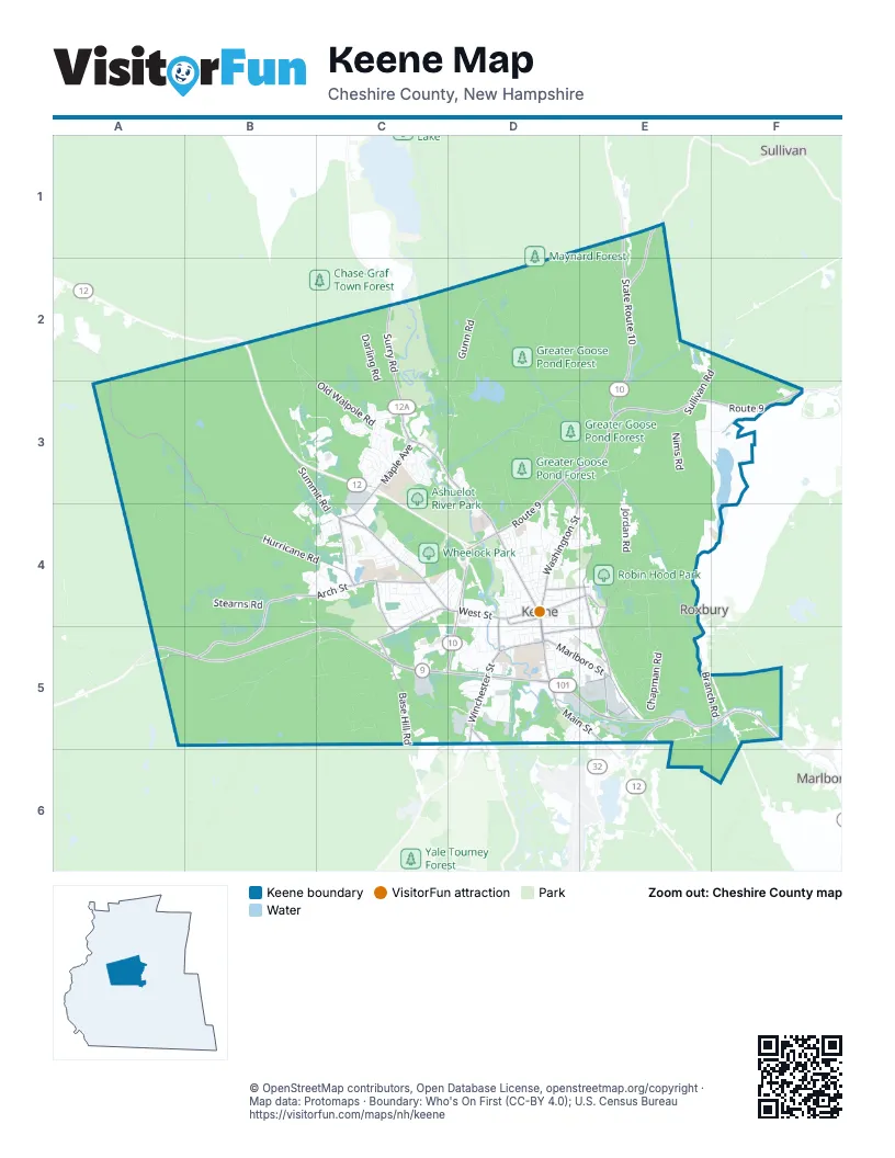
Street index of Keene
Each street on the sheet and the grid squares it crosses.
- Route 9D3, E3, F3, D4, C5, D5
- Franklin Pierce HighwayA5, B5, C5
- Marlboro StreetD5, E5, F5
- State Route 101D5, E5
- Main StreetD4, D5, E5
- State Route 10E2, E3, C5, D5
- Winchester StreetD5
- Route 10E1, E2
- Monadnock HighwayE5
- NH Route 9F3
- West Swanzey RoadD5
- Court StreetC3, D3, D4
- Washington StreetD3, D4
- West Surry RoadC2, C3
- Maple AvenueC3, C4
- Central SquareD4
- Old Homestead HighwayE5
- Hurricane RoadA3, B3, B4, C4
- West StreetC4, D4, C5
- Arch StreetB4, C4
- Chesterfield RoadB4, A5, B5
- Park AvenueC4
- Base Hill RoadC5
- Roxbury StreetD4, E4
- Summit RoadB3, C3, C4
- Water StreetE4, D5, E5
- Sullivan Centre StreetE1, E2
- Optical AvenueE5
- Bradford RoadC4, C5
- Hastings AvenueC4
- North Lincoln StreetE4
- Eastern AvenueE5
- Beaver StreetD4, E4
- Swanzey Factory RoadE5
- Gilbo AvenueD4
- Island StreetD4, D5
- South Lincoln StreetE4, E5
- Tiffin StreetE5
- Matthews RoadD5
- Winchester Street RoundaboutD5
- Chapman RoadE4, E5
- East Surry RoadC2, C3, D3
- Old Walpole RoadB2, C3
- Daniels Hill RoadB5, C5
- Concord RoadE3, D4, E4
- Gunn RoadD2, C3, D3
- Darling RoadC2, C3
- Wyman RoadB2, B3, C3
- Jordan RoadE3, E4
- Elm StreetD4
- Old Concord RoadE3, F3, E4
- Pako AvenueC3
- Roxbury RoadE4
- Sullivan RoadE2, F2, E3
- Stearns RoadB4
- Peg Shop RoadE4
- Skyline DriveB4, C4
- Timberlane DriveD3, D4
- Liberty LaneC3
- Gilsum StreetD4
- Pearl StreetD4, D5
- Oriole AvenueC3
- Dickinson RoadB4
- Krif RoadD5
- Nims RoadE3
- Whitcomb's Mill RoadB4, C4, C5
- Kennedy DriveC3
- Greenwood AvenueD5, E5
- Butternut DriveC3
- Ridgewood AvenueC4
- Langley RoadB5
- Sparrow StreetC3
- Branch RoadE5, F5
- Acrebrook RoadD3
- Meetinghouse RoadD3
- School StreetD4, D5
- Kendall RoadC4
- Ferry Brook RoadE2, E3
- Graves RoadE5, E6
- Belvedere RoadE1, E2
- Baker StreetD5, E5
- Key RoadD5
- Church StreetD4, E4
- Ash Brook RoadC5
- Cornwell DriveD5
- Starling StreetC3
- Felt RoadB4, C4
- Sesame StreetC3
- George StreetD4, E4
- Sullivan StreetE4
- Woods RoadD3
- Emerald StreetD5
- Rose LaneE5
- North StreetD4
- Silent WayD5
- Rule StreetE4
- Summit Ridge DriveB3, C3, B4
- Carroll StreetD4
- Production AvenueC5
- Blossom StreetC4
- Hilltop DriveC3
- Greenbriar RoadC4
- Russell StreetC4, D4
- Red Oak DriveE1
- Howard StreetD4
- Aldrich RoadB4
- Robbins RoadC4
- River StreetD4
- Castle StreetD4
- Armory StreetD4
- Pine AvenueC4, D4
- Grimes RoadB5
- High StreetD4
- Martell CourtD5
- Thompson RoadE5
- Farmstead CommonsC5
- Woodbury StreetD4
- Cranberry RoadE5
- Spruce StreetD4
- Blackberry LaneB4, C4
- Davis StreetD5
- Birch StreetC4
- Wildwood RoadC4
- Schult StreetC5
- Cross StreetD4
- Hanover StreetC4
- Ash Brook CourtC5
- Wilson StreetD4, D5
- Adams StreetD5
- Sweeney RoadC4
- Chapel DriveE4
- Laura LaneC3
- Moore Farm RoadE3
- Forest StreetD4
- Knight StreetD4, E4
- Dale DriveC3
- Forge StreetB3
- Royal AvenueC4
- American AvenueC3
- Belmont AvenueD5, E5
- Evans LaneC4
- Fairbanks StreetD5
- Newman StreetC4, D4
- Colonial DriveC3
- Fox CircleD4
- Beech Hill TrailE5
- Railroad StreetD4
- Wilber StreetE4, E5
- Butler CourtD5
- Congress StreetE5
- Citizens WayD4
- Woodland AvenueE4, E5
- Eastview RoadC3
- Kit StreetD5
- Edgewood AvenueD5, E5
- Evans CircleC4
- Arlington AvenueC4
- Windsor CourtD3
- East Diane CircleD4
- Shadow LaneC4
- McKinley StreetC4, D4
- Washington Street ExtendedE3, E4
- Meadow RoadD5
- Pheasant Hill RoadE5
- Allen CourtD3, D4
- Stonehouse LaneC4
- Lynwood AvenueD5, E5
- Blue Jay CourtC3
- Reservoir StreetE4
- Union StreetD4
- Ashuelot StreetD4
- Foxwood AvenueD4
- Spring StreetD4
- Pinehurst AvenueC4
- Wood StreetD5
- Woodburn StreetD4
- Colby StreetD5, E5
- WillowbrookC4
- Starlight DriveC4
- Douglass StreetD4
- Kings LaneD3
- Valley StreetE4, E5
- Carpenter StreetD4, D5
- Salisbury RoadC4
- Mayflower DriveD4
- Queens RoadC4
- Corporate DriveC3
- Green Acres RoadD4
- Forestview RoadB4
- Mountain View DriveC3
- Colorado StreetD4
- Wetmore StreetD5
- Trowbridge RoadC4
- Concord Hill DriveE3
- Robin Hood LaneE4
- Ellis CourtD4
- Terrace StreetE4
- Algonquin DriveD3
- Dunbar StreetD5
- Finch StreetC3
- Grant StreetE4
- Woodridge RoadC3
- Page StreetD4
- Minerva LaneF5
- Ralston StreetD5
- West Hill RoadC5
- Fairview StreetD4
- Community WayD4, D5
- Franklin StreetD4
- West Diane DriveD4
- Grove StreetD5
- Winter StreetD4
- Buffum RoadD5
- Woodside AvenueE5
- Andover StreetC4
- Wilder StreetD4
- Kelleher StreetD5
- Wyman WayD5
- Bradco RoadD5
- Crestview StreetD4
- Park StreetD4
- Blake StreetD5
- New Acres RoadD4
- Mechanic StreetD4
- Prospect StreetD4
- Crescent StreetD5
- Hillside AvenueE5
- Joslin Station RoadE5
- Billings AvenueC4
- Colonial Village DriveE5
- Marshall CourtD4
- Sawyer RoadC4
- Dover StreetD4
- Fox AvenueD4
- Olivo RoadC4
- Lee StreetD5
- Martin StreetE5
- Phil LaneD4
- Westminster CourtD3
- Victoria StreetE5
- Giffin StreetD4, E4
- Gemini DriveC3
- Stanhope AvenueC4
- Pitcher StreetC4
- South StreetD5
- Westview AvenueD4
- Willow StreetD5
- Cottage StreetD4
- Krif CourtD5
- Washington AvenueD4
- Beech StreetD4
- Leverett StreetD4
- Lucinda TerraceD5
- Nelson StreetD4
- Eagle CourtD4, D5
- Wheelock StreetC4
- Victoria CourtE5
- Worcester StreetC4
- Kenworth AvenueD5
- Summer StreetD4
- Shady LaneC3
- Rowe AvenueC4
- Autumn Hill RoadC3
- Bellevue StreetE5
- Cedar StreetC4
- Wakefield StreetC4
- Manchester StreetD5
- Drummer RoadD4
- Westlund AvenueC4
- Probate StreetD4, E4
- Morin AvenueC4
- Leahy RoadC4
- Evergreen AvenueD3
- Rockwood RoadC3
- Skyview CircleB4
- Vine StreetD4
- Blaine StreetD5
- Harmony LaneD4
- Newbury LaneB4
- Brook StreetD4
- Marguerite StreetC4
- Pine StreetD4
- Apollo AvenueC3
- Cone StreetC4
- Foster StreetD5
- Upper Knight StreetD4, E4
- Marshall StreetD4
- Monadnock StreetD5
- Gates StreetD5
- Glen RoadC3
- Highland AvenueE4
- Imperial DriveC5
- Avon StreetD4
- Elliot StreetD5
- Edwards StreetD4
- Depot RoadE5
- South View DriveC3
- Portland StreetD4
- Vernon StreetD4
- Hooper StreetD5
Things to do on the Keene map
Places on the map
- American Legion Fields
- Appian Way
- Ashuelot River Park
- Beaver Brook Canyon
- Beech Hill
- Beech Hill Preserve
- Bretwood Golf Course
- Brickyard Pond
- Cheshire Medical Center
- Cheshire Medical Center Library
- Cheshire Medical Center West
- Courtyard Keene Downtown
- Covenant Living of Keene
- Dinsmoor Woods
- Goose Pond
- Grays Hill
- Greater Goose Pond Forest
- Greenlawn Cemetery
- Horatio Colony Nature Preserve
- John H. Fuller School
- Jonathan Daniels Preschool
- Joyce Athletic Fields
- Keene Country Club
- Keene High School
- Keene Middle School
- Key Road Plaza
- Ladies Wildwood Park
- Langdon Place of Keene
- Markem Property
- Monadnock Marketplace
- Monadnock View Cemetery
- Otter Brook Lake
- Riverside Plaza
- Robin Hood Park
- Robinhood Park Reservoir
- Shadow Lake Park
- Stearns Hill
- Stonewall Farm
- Wheelock Park
- Woodland Cemetery
Next to Keene
- Marlborough
- Roxbury
- Sullivan
© OpenStreetMap contributors, Open Database License, openstreetmap.org/copyright · Map data: Protomaps · Boundary: Who's On First (CC-BY 4.0); U.S. Census Bureau















