

New Hampshire map
Laconia map
About 17,310 people live here (Census Bureau, 2024 estimate). The sheet's index lists 300 streets; Meredith Center Road, White Oaks Road and Endicott Street North cross the most grid squares. Things to do inside the boundary: Funspot, Laconia Rail Bikes and M/S Mount Washington.
Open the map (PDF, US Letter)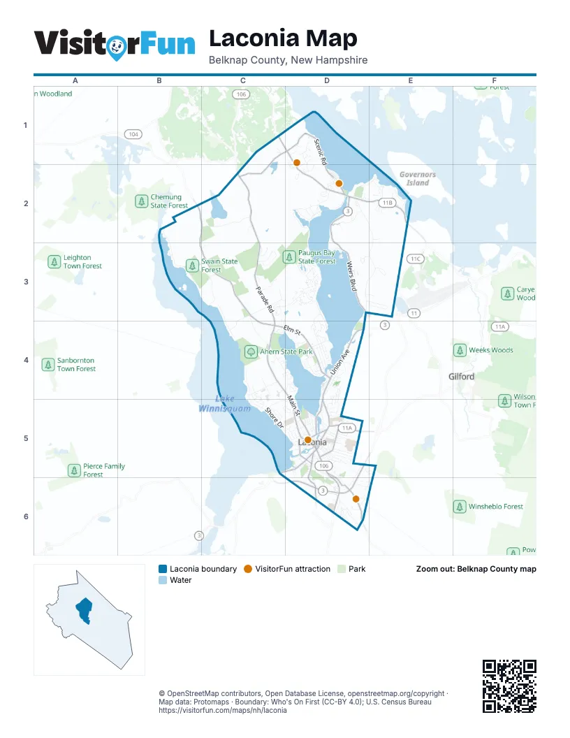
Street index of Laconia
Each street on the sheet and the grid squares it crosses.
- Weirs BoulevardD2, D3
- Union AvenueD4, D5
- Endicott Street NorthC1, D1, D2
- Laconia BypassD5, D6
- Endicott Street EastD2, E2
- South Main StreetD5, D6
- Court StreetC5, D5
- Belmont RoadD5, D6
- Lake StreetD3, D4
- Main StreetD5
- Daniel Webster HighwayD2
- Parade RoadC2, C3, C4
- North Main StreetC4, D4, D5
- Province RoadD6
- Gilford AvenueD5
- Beacon Street WestD5
- Weirs RoadE2
- Veterans SquareD5
- Meredith Center RoadB2, C2, B3, C3, C4
- Elm StreetC4, D4
- Roller Coaster RoadC1, D1, C2
- Pleasant StreetD5
- Scenic RoadD1, D2
- Messer StreetD5
- Watson RoadD1
- Lakeside AvenueD2
- Highland StreetD5
- Academy StreetD5, D6
- Mile Hill RoadD6
- Fair StreetD5
- Church StreetD5
- New Salem StreetD5
- Pine StreetD5
- White Oaks RoadD2, E2, D3, E3
- Shore DriveC4, C5, D5
- Outerbridge DriveC3, D3
- Leighton Avenue NorthB2, B3
- Old North Main StreetC4, D4
- Pickerel Pond RoadC2
- Hilliard RoadD2
- Turner WayC3
- Davidson DriveD3
- Hillcrest DriveD3, E3
- North StreetD4
- Soleil MountainD1, D2
- Holman StreetC5, D5
- Mechanic StreetD4
- Ahern Park RoadC4
- Province StreetD5, D6
- Lexington DriveC4
- Right Way PathC4
- Ledges DriveD4, D5
- Benton DriveD6
- Paugus Park RoadD3, D4
- Sheridan StreetD4
- Mentor AvenueD2
- Daisy Gardner RoadB3, C3
- Hounsell AvenueD5, D6
- Eastman Shore Road NorthC3, C4
- Morningside DriveD4
- Belvidere StreetD4
- Baldwin StreetD5
- Eastman RoadC3, C4
- Pine Hollow RoadD1, D2
- Washington StreetD4
- Akwa VistaD2
- Garfield StreetD5, D6
- Long Bay DriveD3
- Franklin StreetD4
- Lady Walsingham WayE3
- Blueberry LaneC5, D5
- Pendleton RoadE2
- Country Club RoadE5, D6, E6
- Warren StreetD5
- Lynnewood RoadC4, C5
- Winter StreetD5
- Old Prescott Hill RoadD6
- Crockett RoadC3
- Van Buren RoadD3, D4
- Hillcroft RoadD2
- Birch Haven RoadD2
- Lane RoadC3
- Pine Street ExtensionD5
- School StreetD4
- Valley StreetD4
- Oak StreetD5
- Darby DriveD6
- Wentworth Cove RoadE2
- Lafayette StreetD5
- Sarah CircleC5, D5
- Water StreetD5
- Nature's View DriveD4
- Shane WayD3
- Cow Path DriveD3
- Lucerne AvenueD2
- Massachusetts AvenueD4
- Frank Bean RoadD6
- Severance RoadC3, D3
- Memory LaneD2
- Taylor Home DriveD5
- Moose Ledge RoadD2
- Harglen LaneD2
- Hickory Stick LaneD4
- Story Tyler Shore RoadC3
- Skyview LaneD2
- Stark StreetD4
- Wildwood RoadC4, C5
- Recreation DriveD3
- McGrath StreetD5
- Jefferson StreetD4
- Anthony DriveC4
- Woodvale DriveE2
- Emerald DriveD5
- Windemere HeightsC3
- Channel LaneD2
- Tyler Shore RoadC3
- Summit AvenueE2
- Leighton Avenue SouthB3
- Sterling DriveE2
- Dartmouth StreetD5
- Cotton Hill RoadD6
- Merrimac StreetD5
- Island DriveD3
- High StreetD5
- Bell StreetD4
- Pendleton Beach RoadD2, E2
- Tower StreetD2
- Plantation RoadE2
- Belknap StreetD5
- Garden CircleC3
- Spring StreetD5
- Barbara BoulevardD5, E5
- Grant StreetD5
- Centenary AvenueD2
- Fenton AvenueD5
- Clover LaneC3
- Singing CoveD2
- Sarasota LaneD3, E3
- Veterans AvenueD2
- Cottonwood AvenueD5
- Mark DriveD6
- Crimson DriveD3
- Lincoln StreetD5
- Wellington DriveD6
- Bisson AvenueD5
- Woodland AvenueD5
- Beacon Street EastD5
- Logan DriveD6
- Morrill StreetD5
- Summer StreetD5
- Ashley DriveE2
- Chapin TerraceD4
- Fairmont StreetD4
- Captain's WalkD3
- Tilton AvenueD6
- Bowman StreetD5
- Deerfield TurnD3
- Prescott AvenueD3
- Kinsman DriveD4, D5
- Old Parade RoadC3
- Webster StreetD5
- Primrose Drive NorthC4
- Winnisquam AvenueD5
- Carriage LaneD3
- Clinton StreetD4
- Hadley RoadC3
- Rolling LaneE2
- Whipple AvenueD5
- Roundbay RoadC4
- Windjammer's RidgeD1
- Gale AvenueD5
- Gillette StreetD5
- Morin RoadD6
- Freedom LaneC3
- Aberry LaneD3
- Lyford StreetD5
- Randlett DriveD6
- Hayes RoadD1
- Linny LaneC3, C4
- Walker StreetD5
- Center StreetD5
- Drummer TrailD3
- Edwards StreetD5
- Gables DriveD3
- Fox Crossing LaneD3
- Wink RoadB2, C2
- New Hope DriveD3, E3
- Primrose Drive SouthC4
- Batchelder StreetD5
- Birchwood WayC5
- Leigh CourtC3, C4
- Normand CircleD2
- Clark AvenueD4
- Avery StreetD5
- Phoenician WayB3, C3
- Bay StreetD5
- Mallard CoveD4
- Parsonage DriveC2
- Perkins DriveD6, E6
- Admirals LaneD3
- Opechee StreetD5
- Edgewater AvenueD5
- Moulton StreetD4
- Tranquility TurnD2
- Brian LaneD4
- Paugus StreetD4
- Magnolia LaneC4
- Clearwater PlaceD4
- Starboard WayD4
- Zion Hill RoadD4
- Overland StreetD5, D6
- Harvard StreetD5
- Pearl StreetD5
- Port WayD4
- Crescent StreetD5
- Eastman Shore Road SouthC4
- Davis PlaceD5
- Breckenridge RoadC1
- Vantage Point DriveD2
- Marshall CourtC4
- Evergreen DriveD3
- Broad View DriveD2
- Commander's HelmD1
- Joanne TerraceD5, E5
- Big Bend RoadD2
- Champagne AvenueD5
- Girard StreetD5
- Fairview StreetD5
- Hampton CourtD3
- Strafford StreetD5
- Gilbert StreetD5
- Siesta LaneD3
- Woodgate CommonsC4
- Bill's WayD2
- Boise CircleD4, D5
- Provencal RoadD6
- Hyatt LaneC3
- Colonial RoadE2
- Eagle DriveD3
- Tiffany DriveD6
- Durkee StreetD5, D6
- Great Bay LaneC4
- Bayside CourtD4
- Dixon StreetD5
- Hutchinson StreetD5
- John Galts WayD1, D2
- Adams StreetD5
- Addison StreetD5
- Windmill LaneD4
- Methodist CircleD2
- Winnicoash StreetD5
- Janna WayD4
- Penny LaneC4
- Foliage LaneD3
- Lantern CircleD3
- Carol CourtD3
- Doe AvenueD2
- Prospect StreetD4
- Dell AvenueD4
- Sanborn StreetD5
- Cardinal DriveD3
- Orchard StreetD5
- Dolloff StreetD5
- Beaman StreetD5
- Drew LaneD3
- Fillmore AvenueE2
- Rowell StreetD5
- Teddington WayD3
- McKinley RoadE2
- Pinenotch CircleE2
- Sandhurst DriveD6
- Heron TraceD3
- Regis RoadE2
- Cottage StreetD5
- Joliet StreetD5
- Ashwood CircleD5
- Pride's Point WayD3
- Railroad AvenueD4
- Yachtsmen's RidgeD1
- West StreetD5
- Manchester StreetD4
- Dudley CircleD6
- Elizabeth TerraceC4
- Havenwood DriveD5
- King CourtD4
- Pond's View DriveD3
- Birdie WayD3
- Hill StreetD4
- Woodwinds Hill DriveD1
- Skipper's CourtD1
- Alpine CircleD3
- Cedar StreetD5
- Diamond PlaceD6
- O'Shea LaneD5
- Howard StreetD5
- Parker StreetD5
- Charlevoix PlaceD5
- Patriots DriveD3
- Academy SquareD5
- Growtth RoadD5
Things to do on the Laconia map
Places on the map
- Ahern State Park
- Bartlett Beach
- Bayside Cemetery
- Belknap County Nursing Home
- Bond Beach Park
- Buckyard Mountain
- Concord Hospital – Laconia
- Elm Street School
- Footes Pond
- Goss Library
- Grand View Motel and Cottages
- Hamel State Forest
- Huston-Morgan State Forest
- Jade Trace
- Laconia High School
- Laconia Middle School
- Laconia Transfer Station
- Lake Opechee Inn and Spa
- Lake Winnisquam
- Leavitt Park
- Maiden Lady Cove
- Memorial Park
- Monkey Trunks Weirs Beach
- Opechee Bay
- Opechee Bay State Forest
- Opechee Park
- Paugus Bay
- Paugus Bay State Forest
- Pickerel Pond
- Pleasant Street School
- Prescott State Forest
- Robbie Mills Sports Complex
- Sacred Heart Cemetery
- Saint Lamberts Cemetery
- Swain State Forest
- Union Cemetery
- UPS
- Weirs Beach
- Weirs Beach Go-Kart Track
- Woodland Heights School
Next to Laconia
- Gilford
© OpenStreetMap contributors, Open Database License, openstreetmap.org/copyright · Map data: Protomaps · Boundary: Who's On First (CC-BY 4.0); U.S. Census Bureau















