

New Hampshire map
Manchester map
About 116,386 people live here (Census Bureau, 2024 estimate). The sheet's index lists 300 streets; Everett Turnpike, South Willow Street and Brown Avenue cross the most grid squares. Things to do inside the boundary: Currier Museum of Art, Greater Manchester Chamber and Manchester Museums.
Open the map (PDF, US Letter)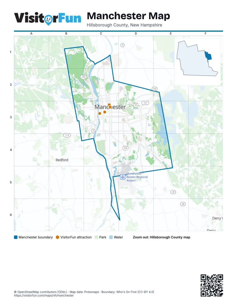
Street index of Manchester
Each street on the sheet and the grid squares it crosses.
- Everett TurnpikeC1, B2, C2, C3, C4
- Alan B Shepard HighwayD4, E4, E5
- Raymond Wieczorek DriveC5
- South Willow StreetC3, C4, D4, D5
- Elm StreetC2, C3
- Beech StreetC2, C3
- Maple StreetC2, C3
- Second StreetC3, C4
- South Beech StreetC3, C4
- Granite StreetC3
- Queen City AvenueC3
- Hooksett RoadC2
- Webster StreetC2, D2
- Londonderry TurnpikeE2
- South Maple StreetC3, C4
- Massabesic Traffic CircleE2
- South River RoadC4
- Brown AvenueC3, C4, C5, C6
- Bridge StreetC3, D3
- Mammoth RoadD2, D3
- Hanover StreetC3, D3
- Candia RoadE2, D3, E3
- Wellington RoadD2, E2, D3
- South Mammoth RoadD3, D4, D5
- Front StreetC1, C2
- Perimeter RoadD4, C5, D5
- Goffstown RoadB2, C2
- Calef RoadC3, C4
- Valley StreetC3, D3
- South Main StreetC3, C4
- Amory StreetB3, C3
- West Bridge StreetC3
- Mast RoadB3, C3
- Massabesic StreetC3, D3
- Hazelton AvenueC5
- Varney StreetB3, C3
- McGregor StreetC3
- Eddy RoadC2, C3
- Amoskeag RotaryC2
- Main StreetC3
- West Hancock StreetC3
- Amoskeag StreetC2
- West Salmon StreetC2
- Candia Road ConnectorD3
- Hanover Street ConnectorD3
- Baker StreetC3
- Roundstone DriveC5
- Frederick StreetC3
- Amoskeag BridgeC2
- Airport RoadC5
- West River RoadC1
- Goffstown Back RoadB2
- Charles Bancroft HighwayC6
- Union StreetC1, C2, C3
- River RoadC1, C2
- Belmont StreetC2, C3
- Chestnut StreetC2, C3
- Bodwell RoadD4, E4, E5
- Canal StreetC2, C3
- Huse RoadD3, D4
- Cohas AvenueD4, E4
- Dunbarton RoadB2, C2
- Island Pond RoadD3, D4, E4
- Lake AvenueC3, D3
- Goffs Falls RoadC4, D4, C5
- Cilley RoadC3, D3
- Smyth RoadC2, D2
- East Industrial Park DriveD3, D4
- Spruce StreetC3, D3
- Coolidge AvenueC2, C3
- Corning RoadD4, C6
- Kelley StreetB3, C3
- Boynton StreetC3, B4, C4
- Salmon StreetC2
- Weston RoadD4
- Harvey RoadD4, D5
- Campbell StreetC2
- Bicentennial DriveC1, C2
- Tarrytown RoadD3
- South Jewett StreetD3, D4
- Jewett StreetD3
- Rockland AvenueB3
- Milford StreetC3
- Donald StreetB3, C3
- Hackett Hill RoadC1
- Mooresville RoadD4
- Sylvester StreetB3, C3
- Woodbury StreetC3
- Carpenter StreetC2
- Rochelle AvenueC3
- West Webster StreetC2
- Hamel DriveC2
- Nazaire Biron BridgeB3
- Pinard StreetB3
- Robert Hall RoadC6, D6
- West Auburn StreetC3
- East Dunbarton RoadB2
- Readey StreetC2
- Old Derry RoadE5
- Rockingham RoadE2
- Lake Shore DriveD3, E3, E4
- Hall StreetC2, C3
- Pine StreetC2, C3
- Hayward StreetC3, D3
- Amherst StreetC3, D3
- Walnut StreetC2, C3
- Oak StreetC2, C3
- Central StreetC3, D3
- Country Side BoulevardB1, C1
- Somerville StreetC3, D3
- Lincoln StreetC3
- Merrimack StreetC3, D3
- Gold StreetC4, D4
- Lowell StreetC3, D3
- Wilson StreetC3
- Bryant RoadD4, E4, E5
- Brent StreetC6
- Ray StreetC2
- Laurel StreetC3, D3
- Bremer StreetB3, C3
- Concord StreetC3, D3
- Auburn StreetC3, D3
- Sagamore StreetC2, D2
- Wellington Hill RoadD2
- Straw RoadB2
- Cedar StreetC3, D3
- Harrison StreetC3, D3
- Blodget StreetC2, D2, C3
- Willow StreetC3
- Holt AvenueD3
- Manchester StreetC3, D3
- Ash StreetC2, C3
- Douglas StreetC3
- North Adams StreetC2
- South Porter StreetD3, D4
- Orange StreetC3
- Prospect StreetC3
- North StreetC2
- Silver StreetC3, D3
- Country Club DriveC2
- Myrtle StreetC3
- Pearl StreetC3
- Clay StreetC3, D3
- Lucas RoadD4, D5
- Cypress StreetD3
- Union Street East BackC2, C3
- Holly AvenueD3, C4
- Dubuque StreetC3
- Linden StreetC2, C3
- Coral AvenueC1, C2
- Upland StreetB2, B3
- Russell StreetC2, C3
- Pickering StreetC2
- Montgomery StreetC2, C3
- East High StreetC3, D3
- Sheffield RoadD4, D5
- Rimmon StreetC3
- Page StreetD3
- Vinton StreetC4, D4
- Litchfield LaneC3
- Proctor RoadD3, E3
- Dubuque Street East BackC3
- Commercial StreetC3
- North Bay StreetC2
- Stark LaneC2
- Currier DriveD2
- Old Wellington RoadD2, D3
- Hevey Street East BackC3
- South Commercial StreetC3
- Kimball StreetB3
- Elgin AvenueC1, C2
- Walnut Street East BackC2, C3
- Harvard StreetC3, D3
- Titus AvenueC4
- Howe StreetC3, D3
- Taylor StreetD3
- Dix StreetC3, D3
- Notre Dame AvenueC3
- Blevens DriveC2, D2
- Hevey StreetC3
- Putnam StreetC3
- Kennard RoadC2, D2
- Whittington StreetD2
- Ashland StreetC2, C3
- Megan DriveE4
- Medford StreetD3
- Cartier StreetC3
- Arah StreetC2
- Greeley StreetB2, C2
- Whitford StreetC2
- Reservoir AvenueC3, D3
- Spruce Street South BackC3
- Eastern AvenueD2, D3
- Porter StreetD3
- Laurel Street South BackC3, D3
- Jack Lovering DriveD4
- Beacon StreetD3
- Brunelle AvenueC4, D4
- Lake Avenue South BackC3
- Riverdale AvenueC4
- Allard DriveC3
- Reed StreetC2, C3
- Frontage RoadC4
- Pepsi RoadD3
- Trolley StreetC6
- West Mitchell StreetC4
- Young StreetC3, D3
- Circle RoadD4
- Grove StreetC3, D3
- Seames DriveC4, D4
- Laydon StreetD3
- Westwood DriveC4
- Oakland AvenueD3
- Mason StreetB3, C3
- Shasta StreetC3
- Bartlett StreetC2, C3
- Brook StreetC3
- Edward J. Roy DriveD2
- Elm Street East BackC2, C3
- Day StreetC2, D2
- Cedar Street South BackC3
- Rimmon Street East BackC3
- Bedford StreetC3
- North Bend DriveC2
- South Taylor StreetD3, D4
- Laxson AvenueC4, D4
- Charlotte StreetC5, C6
- Tory RoadC2
- Youville StreetC2, C3
- John E. Devine DriveC4, D4
- Karatzas AvenueD2, D3
- Dunbar StreetC4
- Woodview WayB1
- North Gate RoadC2
- Paquette AvenueC2
- Rosegate Farm DriveD4
- Youville Street East BackC2, C3
- Monadnock LaneC3
- Kearney CircleC2
- Woodcrest CourtD3
- Mystic StreetC4
- Montgomery Street East BackC3
- Aaron DriveE4, E5
- Phillip StreetB2
- Blucher StreetC3
- Reed Street East BackC3
- Abby RoadD5
- Hunters Village WayC4
- Mitchell StreetC4
- Lindstrom LaneD2
- South Elm StreetC3, C4
- Fox Hollow WayD2
- Crescent RoadC4
- Merrill StreetC3, D3
- Fremont StreetD3
- Chase WayC1
- Gay StreetC4, C5
- Whitney AvenueC1, C2
- Eve StreetC2
- Auburn Street South BackC3
- Hidden Oak WayC1
- Londonderry LaneC3
- Pine Street East BackC2, C3
- West Haven RoadC2, D2
- Pond DriveC4, C5
- Beaver StreetD3
- Alliance WayB1
- Pleasant Pond WayB1
- Joseph StreetB2
- Beech Street East BackC2, C3
- Lovering StreetD3
- Merrimack Street South BackC3
- Hoyt StreetD4
- Hermit RoadE4
- Ash Street East BackC2, C3
- Maryland AvenueD3
- Manning StreetC3, D3
- South Hall StreetC3, C4
- Rhode Island AvenueD3
- Sibley TerraceD4
- Cranwell DriveD3
- Green Acres DriveD3
- Agnes StreetB3
- Knollwood WayB1
- March AvenueC4, D4
- Sewall StreetC4
- Ward StreetC2
- Chauncey AvenueC2
- Green StreetC3
- North Commercial StreetC3
- Jobin DriveC4, D4
- Highview TerraceD2
- Hillhaven RoadD2
- Sundial AvenueC3, C4
- Gray StreetD3
- Sullivan StreetC3
- Allen StreetB3, C3, C4
- Woodland AvenueD3
- Norcross StreetD3
- Ledgewood WayD3
Things to do on the Manchester map
Places on the map
- 1525 Plaza
- American Canadian Genealogical Society
- Assumption Greek Church
- Bald Hill
- BJ's Wholesale Club
- Blodgett Park / Black Brook
- Center View Plaza
- Crystal Lake
- Dartmouth-Hitchcock Manchester
- Derryfield Country Club
- Derryfield Park
- Dorrs Pond
- East Side Plaza
- Elliot Hospital
- Fletcher Island
- Great Cohas Swamp
- Intervale Country Club
- Livingston Park
- Long Pond
- Mall of New Hampshire
- Manchester Cedar Swamp Preserve
- Manchester Commons
- Manchester Dunbarton Road Landfill
- Massabesic Lake
- McIntyre Ski Area
- Mount Calvary Cemetery
- Nutts Pond
- Old Saint Josephs Cemetery
- Pine Grove Cemetery
- Pine Island Pond
- Piscataquog River
- Precourt Park
- Rock Rimmon Park
- Sisters of the Precious Blood
- Stevens Pond
- Stevens Pond Park
- The Derryfield School
- VA Medical Center
Next to Manchester
- Bedford
- Derry
- Derry Village
© OpenStreetMap contributors, Open Database License, openstreetmap.org/copyright · Map data: Protomaps · Boundary: Who's On First (CC-BY 4.0); U.S. Census Bureau