

New Jersey map
Camden map
About 71,749 people live here (Census Bureau, 2024 estimate). The sheet's index lists 300 streets; North–South Freeway, Federal Street and Mount Ephraim Avenue cross the most grid squares. Things to do inside the boundary: Battleship New Jersey Museum & Memorial and Adventure Aquarium.
Open the map (PDF, US Letter)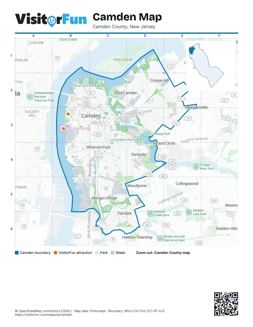
Street index of Camden
Each street on the sheet and the grid squares it crosses.
- North–South FreewayB2, C2, C3, C4, C5, C6
- Admiral Wilson BoulevardC2, C3, D3
- Walt Whitman Bridge ExtensionC6, D6
- Federal StreetE2, B3, C3, D3, E3
- BroadwayC3, C4, B5, C5
- Haddon AvenueC3, C4, D4
- Mount Ephraim AvenueC3, C4, C5, D5, D6
- Doctor Martin Luther King Junior BoulevardB3, C3
- River AvenueD1, D2, C3
- Cooper StreetB2, B3, C3, D3
- Pine StreetB3, C3
- North 7th StreetC2, C3
- Crescent BoulevardD5, D6
- Market StreetB2, B3, C3
- Linden StreetB2, C2, C3
- South Crescent BoulevardE2, E3, D4
- South 11th StreetC3
- Black Horse PikeD6
- Wright AvenueC3
- North BroadwayC2, C3
- Flanders BoulevardC3
- White Horse PikeD4
- Federal Ovp StreetE2
- Broadway TurnpikeB5
- Kaighns AvenueB4, C4, D4
- Ferry AvenueB4, C4, D4, C5, D5
- South 8th StreetC3, C4, C5
- Baird BoulevardD3, D4
- South 7th StreetC3, C4, C5
- Collings RoadC6, D6
- Atlantic AvenueB4, C4, D4
- North 27th StreetD2, D3
- State StreetB2, C2
- East State StreetC2, D2, D3
- Marlton PikeD3, E3
- Morgan StreetC5
- Master StreetC4, C5
- North 10th StreetC2, C3
- South 27th StreetD3, E3
- Cambridge AvenueD2
- North Collings RoadC6
- Jersey Joe Walcott BoulevardB3
- Haddon Avenue ApproachD4
- Park BoulevardC3, D3, C4, D4
- South 10th StreetC3, C4, C5
- South 4th StreetB3, B4, B5
- Chestnut StreetB4, C4
- Westfield AvenueD2, E2, D3
- Newton AvenueC3, B4, C4
- South 3rd StreetB3, B4
- Line StreetB3, C3, E3
- Clinton StreetB3, C3, D3, E3
- North 2nd StreetB2, B3
- Pearl StreetB2, C2
- North 3rd StreetB2, B3
- South 2nd StreetB3, B4, B5
- Vine StreetB2, C2
- Fairview StreetC5, D5
- North 6th StreetC2, C3
- Elm StreetB2, C2
- Erie StreetB2, C2
- Delaware AvenueB2, B3
- Vesper BoulevardD4
- North 36th StreetE1, E2
- Highland AvenueE3
- Alabama RoadC6, D6
- Yorkship RoadC5, C6
- Riverside DriveB2, B3
- Randolph StreetD3
- South Delaware AvenueB3
- Main StreetB2
- Memorial AvenueC3
- Morgan BoulevardC5
- Kearsarge RoadC6
- Terrace AvenueE2, E3
- Yorkship SquareC6
- Myrtle AvenueE3
- South Park DriveD4
- Somerset StreetD3
- South 9th StreetC3, C4, C5
- South 6th StreetC3, C4, C5
- Harrison AvenueD1, C2, D2
- High StreetD2, E2, D3
- Pierce AvenueD1, C2, D2
- Jackson StreetB4, C4, D4
- North 32nd StreetD1, D2, E2
- Mechanic StreetB4, C4, D4
- Carl Miller BoulevardB4, C4, D4
- North 34th StreetD1, D2, E2
- Walnut StreetC3, B4, C4
- Liberty StreetB4, C4
- Hayes AvenueE1, D2, E2
- Carman StreetC3, D3, E3
- North 28th StreetD1, D2, D3
- Lansdowne AvenueB4, C4, D4
- North 29th StreetD1, D2
- Mickle StreetC3, D3, E3
- Spruce StreetB3, C3
- Mount Vernon StreetC3, B4, C4
- Sycamore StreetB4, C4
- Penn StreetB2, C2, C3
- Benson StreetB3, C3, D3, E3
- North 33rd StreetD1, D2, E2
- Beideman AvenueD1, D2, E2
- Everett StreetC4, D4
- North 4th StreetB2, C2, B3
- South Front StreetB3, B4
- Princess AvenueC3, C4, D4
- Berkley StreetB3, C3, D3, E3
- North 31st StreetD1, D2, E2
- Wayne AvenueC2, D2
- North 35th StreetD1, E1, E2
- Jefferson StreetB5, C5
- South 5th StreetB3, B4
- Washington StreetB3, C3, D3, E3
- North 30th StreetD2, E2, E3
- North 5th StreetB2, C2, B3
- Thurman StreetC4, D4
- Royden StreetB3, C3, E3
- York StreetB2, C2
- North 25th StreetD2, D3
- North 24th StreetD2, D3
- Stevens StreetB3, C3, D3, E3
- Chelton AvenueB5, C5
- Louis StreetC4
- Cleveland AvenueD2, E2
- Boyd StreetD3
- Kenwood AvenueC3, C4, D4
- Norris StreetC4, D4
- North 26th StreetD2, D3
- Cherry StreetB3, C3, B4
- North Congress RoadC5, D5, D6
- Howell StreetD2, D3
- Fremont AvenueE3
- Ramona Gonzalez StreetB3, C3
- Saunders StreetD2, E2
- Rosedale AvenueE2
- Rand StreetD3
- Bergen AvenueD1, D2
- Morse StreetD3
- Morton StreetC4, D4
- Whitman AvenueB4, C4, D4
- North Front StreetB2, B3
- Pleasant StreetD2, E2
- Sheridan StreetC4, D4
- Bailey StreetB2, C2
- Centennial DriveC2
- Tuckahoe RoadC5, C6
- Pershing StreetD4
- Pfeiffer StreetD3
- North 9th StreetC2, C3
- North 22nd StreetD2, D3
- Lois AvenueD1, D2
- South Merrimac RoadC6, D6
- North 8th StreetC2, C3
- North 21st StreetD2, D3
- North Constitution RoadC5, C6, D6
- Bank StreetD3
- Locust StreetB3, B4
- Cramer StreetD2, E2, D3
- Grant StreetB2, C2
- Sayrs AvenueC4, D4
- Colt AvenueD4
- Waldorf AvenueE3
- Lake Shore DriveC5, D5
- Raritan StreetD3
- Filmore StreetC4, C5
- North 23rd StreetD2, D3
- Lemuel AvenueD2, E2
- South 30th StreetE3
- Kossuth StreetC4, C5
- Bradley AvenueD4
- Thorn StreetD4
- Decatur StreetC4, D4
- Mitchell StreetD2, E2
- Larch StreetB2, C2
- Langham AvenueC3, D4
- Mulford StreetC4, C5
- Empire AvenueC3, D3, D4
- Euclid AvenueD4
- Chase StreetC4, D4
- Central AvenueC4
- North 20th StreetC2, D2, D3
- North 19th StreetC2, D2, D3
- West StreetB3
- Magnolia AvenueC3, D3, D4
- Ware StreetC5
- Hallowell LaneD4, D5
- Thorndyke StreetD3
- Woodland AvenueC5
- Lee AvenueE3
- Sylvan StreetC5
- North 39th StreetE2
- South 19th StreetD3
- South 32nd StreetE2, E3
- Ormond AvenueD4
- South 29th StreetD3, E3
- Rowe StreetD2, E2
- North 37th StreetE2
- Wildwood AvenueD3, C4
- Phillips StreetC4, C5
- Saint John StreetC3, C4
- Viola StreetB4, C4
- Dayton StreetC4, D4
- North 38th StreetE2
- Lawrence StreetB2, C3
- South 33rd StreetE2, E3
- Browning StreetC4, D4
- Byron StreetB2, C2
- Water StreetB2
- Arthur AvenueD2
- Farragut AvenueD1
- Independence RoadD6
- Greenwood AvenueD4
- Rose StreetC4
- North 40th StreetE2
- Garden AvenueE3
- Cedar StreetB2, C2
- MacArthur DriveC5
- South 17th StreetD3
- East Davis StreetD4, D5
- North 41st StreetE2
- Point StreetB2
- Westminster AvenueD3
- Lowell StreetC4
- Henry StreetB3
- South Dudley StreetE3
- Thompson StreetD2
- North Atlanta RoadD6
- Sherman AvenueD2
- North 17th StreetC2, D2
- South 34th StreetE2, E3
- Van Buren StreetC4, C5
- North Dudley StreetE2, E3
- Royal AvenueE3
- Camden Petty IslandD1
- Tulip StreetC5
- South 16th StreetC3, D3
- Venner StreetD4
- Garfield AvenueD2, E3
- Florence StreetC5
- Minnesota RoadD6
- South 28th StreetD3
- North Chesapeake RoadC6, D6
- Buren AvenueD1, D2
- Birch StreetB2, C2
- Moro StreetC2, D2
- Jones StreetD3
- Dudley StreetD2, E2
- Amber StreetB4, C4
- Reeves AvenueD2
- Campbell PlaceC3
- Hillside AvenueE3
- Charm StreetB3
- Sumter RoadC6
- Tilghman DriveC4
- Division StreetB3, C3
- South 35th StreetE2, E3
- Berwick StreetD3
- Station DriveD4, D5
- Fountain AvenueE3
- Eutaw AvenueD3
- Trenton AvenueC3
- Lincoln AvenueD2
- Polk AvenueD2
- Tyler StreetD2
- Herbert TerraceD3
- Concord AvenueD2
- North 18th StreetC2, D2
- South 20th StreetD3
- St Mihiel AvenueC3
- Kansas RoadC5, C6
- Bulson StreetC5
- Grand AvenueD3
- Sewell StreetD3
- Arch StreetB3
- North Merrimac RoadC5, D5, C6, D6
- Niagara RoadC6
- Burwood AvenueE3
- South 36th StreetE2, E3
- Trent RoadC6
- Merriel AvenueE2
- Copewood StreetD4
- Tioga StreetC4
- Hunter DriveC5
- Morrison StreetD2, E2
- Winslow StreetB5, C5
- Monitor RoadC6
- Cope StreetC4
- Silver StreetC3
- Fairmount StreetC4
- Warsaw StreetC4
- Beckett StreetB3
- Williams StreetB3
- Belleview AvenueD4
- Hunter StreetC5
- Adams AvenueD1
- Evans StreetB3
- West Octagon RoadC6
- Roberts StreetC3
Things to do on the Camden map
Places on the map
- 27th Street Revival Center
- 4th & Washington St. Park
- 5 Point Auto Repair
- 7-Eleven
- 76ers Training Complex
- A & A Soft Pretzel Baking
- A&A Glass
- ABC Companies
- Camden Athletic Complex
- Camden Cemetery
- Camden Children's Garden
- Camden County Park
- Camden High School
- Camden Kroc Center
- Camden Pride Charter School
- Campbell Soup Company World Headquarters
- Conrail Pavonia Yard
- Cooper University Hospital
- Cooper's Poynt Park
- Cramer Hill Waterfront Park
- Dudley Grange Park
- East Camden Post Office
- Evergreen Cemetery
- Farnham Park
- Gateway Park
- Judge Robert Johnson Park
- L3Harris Technologies
- New Camden Cemetery
- Pyne Point Park
- Reverend Evers Park
- Rutgers University Camden Quad
- Union Field
- United States Post Office
- USS New Jersey
- Virtua Our Lady of Lourdes Hospital
- Von Nieda Park
- Waterfront Walkway
- Whitman Park
Next to Camden
- Airport Circle
- Audubon Park
- Chinatown
- Collingswood map
- Delaware Gardens
- Fishtown
- Gloucester Heights
- Haddon Hills
- Haddon Township map
- Little Saigon
- Ludlow
- Merchantville
- Morrisville
- Northbank
- Northern Liberties
- Oaklyn
- Old City
- Olde Kensington
- Pennsauken Township map
- Pennsport
- Poplar
- Queen Village
- Society Hill
- West Collingswood
- Westmont
- Whitman
- Woodlynne
- Yorktown
© OpenStreetMap contributors, Open Database License, openstreetmap.org/copyright · Map data: Protomaps · Boundary: Who's On First (CC-BY 4.0); U.S. Census Bureau















