

New Jersey map
Delaware River Region map
The sheet's index lists 23 highways; I-295, US 130 and US 40 cross the most grid squares. Things to do inside the boundary: Adventure Aquarium, Battleship New Jersey Museum & Memorial and Beverly National Cemetery. Also on it: Bordentown Township, Camden and Cherry Hill Township.
Open the map (PDF, US Letter)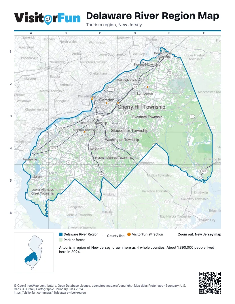
Highway index of Delaware River Region
Each highway on the sheet and the grid squares it crosses.
- I-76C3
- I-95D1, E1
- I-295A4, B3, B4, C3, D2, D3, E1, E2
- I-676C2, C3
- US 9F5
- US 30C2, C3, D3, D4
- US 40A4, B4, B5, C5, D5
- US 130B3, C2, C3, D1, D2, E1
- US 206E1, E2, E3, E4
- US 322B3, B4, C4, D4, D5
- NJ 38C2, C3, D2, E2
- NJ 42C3, C4
- NJ 45B4
- NJ 47C4, C5
- NJ 49A4, A5, B5
- NJ 55C3, C4, C5
- NJ 68E1, E2
- NJ 70C3, D3, E3, F2, F3
- NJ 72E3, F3
- NJ 73C2, D2, D3, D4
- NJ 90C2
- NJ 140A4
- NJ 413D2
Things to do on the Delaware River Region map
- Adventure Aquarium
- Battleship New Jersey Museum & Memorial
- Beverly National Cemetery
- Burlington County Prison Museum
- Cooper River Park
- Deptford Mall
- East Gate Square
- Edelman Fossil Park & Museum
- Finn's Point National Cemetery
- Holiday Inn Philadelphia-Cherry Hill
- Red Bank Battlefield Park
- South Jersey
- The RCA Heritage Program Museum
Places on the map
- Bordentown Township
- Camden
- Cherry Hill Township
- Clayton
- Deptford Township
- Evesham Township
- Florence Township
- Glassboro
- Gloucester Township
- Lower Alloways Creek Township
- Lumberton
- Mantua Township
- Monroe Township
- Pennsville
- Salem
- Washington Township
- Willingboro Township
Next to Delaware River Region
- Northern Delaware
- Central Jersey map
- Greater Atlantic City Region map
- Shore Region map
- Southern Shore map
- Philadelphia and the Countryside
© OpenStreetMap contributors, Open Database License, openstreetmap.org/copyright · Map data: Protomaps · Boundary: U.S. Census Bureau, Cartographic Boundary Files 2024