

New Jersey map
Dover map
About 18,909 people live here (Census Bureau, 2024 estimate). The sheet's index lists 224 streets; Richboynton Road, North Sussex Street and East McFarlan Street cross the most grid squares. Also on it: Saint Clare's Dover Hospital, Waterworks Park and Zuffal Health - Dover Medical.
Open the map (PDF, US Letter)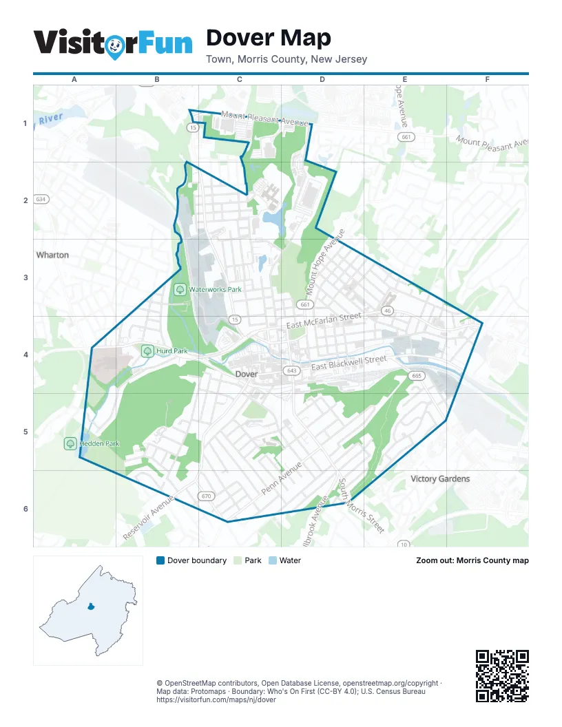
Street index of Dover
Each street on the sheet and the grid squares it crosses.
- MarketPlaceB1, C1
- Mount Pleasant AvenueB1, C1
- West Union TurnpikeB1
- Commerce Center DriveD1, D2
- Bowlby StreetB2
- Edison StreetB2, C2
- Grace StreetB2, C2
- Leonard StreetB2, C2
- Richboynton RoadB2, C2, B3, C3, C4
- Sickle StreetB2, C2
- Vail StreetB2
- White StreetB2, C2
- Baker StreetC2, C3, C4
- Berkshire AvenueC2
- Center StreetC2
- Garrison AvenueC2
- Highland AvenueC2, C3
- Hillside AvenueC2
- James StreetC2, C3
- Jefferson AvenueC2
- North StreetC2, C3
- Turner StreetC2
- West Clinton StreetC2, C3, C4
- North Sussex StreetD2, C3, D3, C4, D4
- Baker AvenueB3, B4
- Columbia StreetB3
- Lehigh StreetB3
- Princeton AvenueB3, B4
- Rutgers StreetB3
- Central AvenueC3
- Davis AvenueC3
- East Fairview AvenueC3
- Goodale AvenueC3
- Lemar StreetC3
- Losey StreetC3, D3
- Parker StreetC3
- Pequannock StreetC3, C4
- Roswell StreetC3, D3
- Segur StreetC3, D3
- West Fairview AvenueC3, C4
- Beech StreetD3
- Berry StreetD3, E3
- Clark StreetD3, E3
- Elm StreetD3, E3
- Guy StreetD3
- Hinchman AvenueD3, D4
- Hoagland AvenueD3, D4
- King StreetD3, E3
- Lincoln AvenueD3, D4
- Locust AvenueD3, D4
- Maple AvenueD3, D4
- Mc Davitt PlaceD3
- Mount Hope AvenueD3, D4
- Oak StreetD3, E3
- Sanford StreetD3, C4, D4
- Searing StreetD3, E3
- Belmont AvenueE3, E4
- Christopher StreetE3
- Conger StreetE3
- Depew AvenueE3, E4
- East Cooper StreetE3
- East Mc Farlan StreetE3
- East McFarlan StreetE3, F3, C4, D4
- Jackson AvenueE3
- John StreetE3
- Nelson StreetE3, E4
- Perry StreetE3, E4
- Schley StreetE3, E4
- Sims StreetE3, E4
- Trenton StreetE3, E4
- Wayne StreetE3, E4
- West Cooper StreetE3
- Ekstrom StreetF3, F4
- Drake AvenueA4
- Elk AvenueA4, B4
- Ford AvenueA4
- Grover RoadA4
- Jardine StreetA4, B4
- West Blackwell StreetA4, B4, C4, D4
- Ann StreetB4, C4, B5, B6
- Bonnie View DriveB4
- Harvard StreetB4
- Hillsdale DriveB4
- North Elk AvenueB4
- Park Heights AvenueB4, A5, B5
- Spring StreetB4, C4, C5
- Taylor PlaceB4, C4
- Walnut StreetB4
- Yale StreetB4
- Bassett HighwayC4, D4
- Chestnut StreetC4, C5
- Dewey StreetC4
- East Clinton StreetC4, D4
- East Dickerson StreetC4, D4
- Elizabeth StreetC4, C5
- Elliott StreetC4
- Front StreetC4
- Legion PlaceC4, C5
- North Warren StreetC4
- Orchard StreetC4, C5
- Prospect StreetC4, C5, B6
- Randolph AvenueC4, C5
- South Warren StreetC4
- Thompson AvenueC4, C5
- West Dickerson StreetC4
- West Elliot StreetC4
- West McFarlan StreetC4
- Bergen StreetD4
- East Blackwell StreetD4, E4, F4
- Essex Street NorthD4
- Essex Street SouthD4
- Hudson StreetD4
- Mase AvenueD4, E4
- Mercer StreetD4
- Monmouth AvenueD4, D5
- Myrtle AvenueD4, E4
- North Morris StreetD4
- Passaic StreetD4
- Richards AvenueD4, E4, F4
- River StreetD4
- South Bergen StreetD4
- South Morris StreetD4, D5, D6
- Union StreetD4
- Beatty StreetE4
- Harding AvenueE4, E5, F5
- Jessica LaneE4
- Julia TerraceE4, E5
- Lynn StreetE4
- North Salem StreetE4
- Rutan DriveE4, F4
- Salem StreetE4
- South Salem StreetE4, E5
- Taft StreetE4, F4, E5
- Wilson StreetE4
- Bloomfield AvenueF4
- Lee AvenueF4
- Palm StreetF4
- Reeves StreetF4
- Sammis AvenueF4
- Welch LaneF4
- Brook LaneA5
- Hawthorne AvenueA5
- Beaufort AvenueB5
- Claredon TerraceB5
- Edgewood TerraceB5, B6
- Euken TerraceB5
- Fox Hill DriveB5
- George StreetB5
- Green Tree LaneB5
- Lawrence StreetB5, C5
- Rockridge TerraceB5
- 2nd StreetC5, D5, D6
- Academy StreetC5, D5
- Arlene LaneC5
- Audrey PlaceC5, C6
- Grant StreetC5, C6
- Jordan TerraceC5, C6, D6
- Kensington AvenueC5, C6
- Liberty StreetC5, C6
- Madison StreetC5, C6
- Pine StreetC5
- South StreetC5
- Spruce StreetC5
- Sylvan AvenueC5
- Tyler StreetC5, D5
- William StreetC5
- 1st StreetD5, D6
- 3rd StreetD5, D6
- Boonton StreetD5, E5
- Byram AvenueD5
- Byram StreetD5
- Cross StreetD5
- East Chrystal StreetD5, E5
- East Munson AvenueD5, E5, D6
- Hillcrest AvenueD5
- Livingston AvenueD5, E5
- Moller PlaceD5
- Mountain AvenueD5
- New StreetD5
- Park AvenueD5
- Park PlaceD5
- Penn AvenueD5, C6, D6
- South Highland AvenueD5
- Summer AvenueD5, E5, D6
- West Chrystal StreetD5, D6
- Bart PlaceE5
- Brook DriveE5, E6
- Carolyn PlaceE5
- Court DriveE5
- Curtis StreetE5, D6
- Elena PlaceE5
- Harrison StreetE5, F5
- Ivan StreetE5
- Kaye PlaceE5
- Kyle DriveE5
- Oram DriveE5
- Victory Hill EastE5
- Watson DriveE5
- Glenmore PlaceB6, C6
- Glenwood AvenueB6
- Greenwood AvenueB6
- Knickerbocker AvenueB6, C6
- Linwood AvenueB6
- Reservoir AvenueB6
- VanNostrand AvenueB6, C6
- Windsor AvenueB6
- 5th StreetC6, D6
- 6th StreetC6, D6
- Conrad PlaceC6
- Everett DriveC6
- Fred TerraceC6
- Grant PlaceC6
- Kearney StreetC6
- North Linden PlaceC6
- Overlook AvenueC6
- Winthrop PlaceC6
- 4th StreetD6
- Cottage StreetD6
- Millbrook AvenueD6
- Searing LaneD6
- Wayside AvenueD6
- West Munson AvenueD6
- Woodland AvenueD6
- Brook Run ApartmentE6
Places on the map
- Academy Street Elementary School
- AM Auto Trimmers
- Casa Puerto Rico
- Casa Verde
- Chase
- Crash Champions Collision Repair
- Crescent Field
- Delizia's Pizza & Kitchen
- Dover Child Care Center
- Dover Fire Department
- Dover High School
- Dover High School Tennis Courts
- Dover Middle School
- Dover Plaza
- Dover Post Office
- Dover Public Library
- Dover Sportsplex
- Dover Town Hall
- ExpressLane
- Extra Supermarket
- First United Methodist Church
- Grace United Methodist Church
- Hamilton Field
- Hedden Pond
- Homewood Suites by Hilton Dover - Rockaway
- Hurd Park
- J.D Automotive & Truck Inc
- JFK Commons
- La-Z-Boy
- Locust Hill Cemetery
- Nielsen Chevrolet
- Ollie's Bargain Outlet
- Orchard Street Cemetery
- Pancho Villa Rodeo
- Pema Marketplace
- Saint Clare's Dover Hospital
- Saint Marys Cemetery
- Waterworks Park
- Zuffal Health - Dover Medical
Next to Dover
- Victory Gardens
- Wharton
© OpenStreetMap contributors, Open Database License, openstreetmap.org/copyright · Map data: Protomaps · Boundary: Who's On First (CC-BY 4.0); U.S. Census Bureau















