

New Jersey map
Haddonfield map
About 12,707 people live here (Census Bureau, 2024 estimate). The sheet's index lists 180 streets; Grove Street, South Atlantic Avenue and East Kings Highway cross the most grid squares. Also on it: Crows Woods Recreation Area, Evans Pond and Hopkins Pond.
Open the map (PDF, US Letter)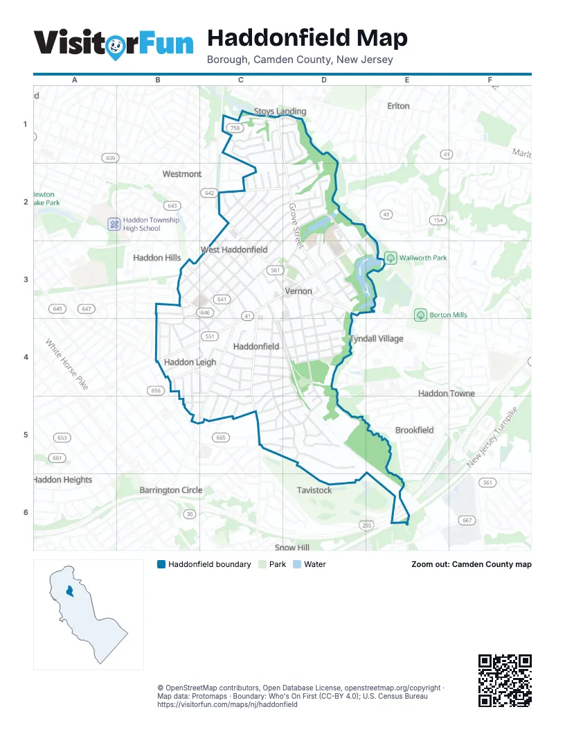
Street index of Haddonfield
Each street on the sheet and the grid squares it crosses.
- Carriage House LaneC1
- Cedar AvenueC1, C2
- Coles Mill RoadC1, D1
- Farwood CircleC1
- Farwood RoadC1
- Grove StreetC1, D1, D2, D3
- Hillside LaneC1
- Jobel DriveC1
- Longwood CircleC1
- Longwood DriveC1
- Meadow DriveC1
- North Edgepark DriveC1, D1
- Pardee LaneC1, D1
- Village CourtC1
- Edge Park DriveD1
- South Edge Park DriveD1
- Wayside LaneD1
- Albany AvenueC2
- Ardmore AvenueC2
- East Emerald AvenueC2
- East Woodland AvenueC2, C3
- Elm AvenueC2, B3, C3
- Hawthorne AvenueC2, D2
- Maple AvenueC2, D2
- Marne AvenueC2
- Merion AvenueC2, D2, C3
- Nicholson LaneC2
- North Haddon AvenueC2, C3, D3
- Princeton AvenueC2
- Radnor AvenueC2
- Redwood AvenueC2, D2
- Rhoads AvenueC2, D2
- South Atlantic AvenueC2, C4, D4, D5
- Wayne AvenueC2
- Windsor AvenueC2, D2, C3
- Wood LaneC2, C3
- Beechwood AvenueD2
- Birdwood AvenueD2
- Bryn Mawr AvenueD2
- East Kings HighwayD2, E2, C3, D3
- Evans Mill RoadD2, E3
- Evergreen LaneD2, D3
- Hopkins AvenueD2, C3
- Hopkins LaneD2, D3
- Legion LaneD2
- Maple CourtD2
- Narberth AvenueD2
- Somerset DriveD2
- The MewsD2, E3
- Kings Highway SouthE2
- Avondale AvenueB3, C3, C4
- Barberry LaneB3, B4
- Graisbury AvenueB3
- Lansdowne AvenueB3, C4
- Peyton AvenueB3, C3
- West End AvenueB3, C3, C4
- West Mount Vernon AvenueB3, C3
- West Redman AvenueB3, C3
- Woodland AvenueB3, C3
- Allen AvenueC3
- Briarcliff CourtC3
- Chestnut StreetC3, D3, D4
- Clement StreetC3, D3
- East Euclid AvenueC3
- East Mount Vernon AvenueC3
- East Redman AvenueC3
- Estaugh AvenueC3
- Lake StreetC3, D3
- Linden AvenueC3
- Mount Vernon AvenueC3
- North Atlantic AvenueC3
- Redman AvenueC3
- Rosedale AvenueC3
- Stiles AvenueC3
- Tanner StreetC3, D3
- Truman AvenueC3
- Veterans LaneC3
- Warwick RoadC3, C4, C5
- Washington AvenueC3, C4, C5, D5
- West Euclid AvenueC3, B4, C4
- West Kings HighwayC3, B4, C4
- Westmont AvenueC3
- Wilkins AvenueC3
- Belmont AvenueD3
- Centre StreetD3, D4, D5
- Colonial AvenueD3
- Douglass AvenueD3, D4
- East Park AvenueD3, D4
- Elizabeth PlaceD3
- Ellis StreetD3
- Fowler AvenueD3
- Friends AvenueD3
- Glover AvenueD3
- Harding AvenueD3
- Kings LaneD3
- Kresson RoadD3
- Lee AvenueD3
- Lincoln AvenueD3, C4, D4
- Mechanic StreetD3
- Morehouse LaneD3
- Park PlaceD3, D4
- Potter StreetD3
- Prospect RoadD3
- Roberts AvenueD3
- Snowden AvenueD3
- South Haddon AvenueD3
- Springfield TerraceD3
- Sylvan Lake AvenueD3
- Thomas Evans AlleyD3
- Walnut StreetD3, D4
- Wellington AvenueD3
- Willits AvenueD3
- Bortons Mill RoadE3
- Bewley RoadB4
- Birchall DriveB4
- Gladstone AvenueB4, B5
- Homestead AvenueB4
- Hopkins RoadB4
- Kings HighwayB4
- Knolltop LaneB4, C4
- Loucroft AvenueB4
- Loucroft RoadB4
- Mansfield AvenueB4
- Marquis RoadB4, C4
- North DriveB4
- North Hinchman AvenueB4
- South Hinchman AvenueB4, C4
- Station AvenueB4, C4
- Westminster AvenueB4, B5
- Bellevue AvenueC4, C5
- Chews Landing RoadC4, B5, C5
- Clinton AvenueC4, C5
- East Atlantic AvenueC4, D4
- Evans AvenueC4
- Eves LaneC4
- Heritage RoadC4, D4, C5
- Hickory LaneC4
- Jefferson AvenueC4, D4
- Lafayette AvenueC4, D4
- Moore LaneC4
- Mountwell AvenueC4, D4
- Overhill RoadC4
- Pomona AvenueC4, C5
- Queensboro LaneC4
- West Cottage AvenueC4, D4
- West Park AvenueC4, D4
- West Summit AvenueC4, D4
- Westwood DriveC4, C5
- Cleveland BoulevardD4
- East Cottage AvenueD4
- East Summit AvenueD4
- Lakeview AvenueD4
- Olney CircleD4
- Park LaneD4
- Reillywood AvenueD4
- Spruce StreetD4
- Treaty Elm LaneD4, C5
- West Atlantic AvenueD4, D5
- Bradshaw AvenueB5, C5
- Clements Bridge RoadB5
- Oak AvenueB5, C5
- Colonial Ridge DriveC5, D5
- Farragut RoadC5
- Gill RoadC5, D5
- Glenwood RoadC5
- Hutchinson AvenueC5
- Tavistock LaneC5, D5, D6
- Upland WayC5, D5
- Wedgewood LaneC5, D5
- Winding WayC5, D5
- Wyndwood RoadC5
- Concord CircleD5
- Concord DriveD5
- East Upland WayD5
- Greenmount RoadD5
- Lane of AcresD5
- Oak Ridge DriveD5
- Pennbrook DriveD5
- Ridgewood CircleD5
- New Jersey TurnpikeE6
Places on the map
- 7-Eleven
- Acme
- Anniversary Field
- Bank of America
- Baptist Cemetery
- Batting Cages
- Carl's Haddonfield Service
- Centennial Field
- Christ the King Roman Catholic Church
- Church of Christ Scientist
- Crows Woods Fields
- Crows Woods Recreation Area
- Dr. Amy James & Associates Orthodontists
- Episcopal Church
- Evans Pond
- Field 1
- Field 2
- Field 3
- Green Acres Field
- Haddon Field Club
- Haddonfield Fire Company Number 1
- Haddonfield Friends Meeting
- Haddonfield Inn
- Haddonfield Little League
- Haddonfield Memorial High School
- Haddonfield Middle School Fields
- Haddonfield Municipal Building
- Haddonfield Plays and Players
- Haddonfield Post Office
- Haddonfield Public Gardens
- Haddonfield Public Library
- Haddonfield United Methodist Church
- Hopkins Pond
- Hopkins Pond Park
- Indian King Tavern Museum
- Jefferson Health
- Jersey Java and Tea
- Public Works of Haddonfield
- Wedgewood Swim Club
Next to Haddonfield
- Barrington Circle
- Brookfield
- Erlton
- Haddon Heights
- Haddon Hills
- Haddon Towne
- Snow Hill
- Stoys Landing
- Tavistock
- Tyndall Village
- Westmont
© OpenStreetMap contributors, Open Database License, openstreetmap.org/copyright · Map data: Protomaps · Boundary: Who's On First (CC-BY 4.0); U.S. Census Bureau















