

New Jersey road map
I-295 in New Jersey map
I-295 is about 74 miles in New Jersey. It has 82 exits, from Exit 1A at mile 1 to Exit 76 at mile 74. It meets 25 highways; US 130, NJ 29 and US 206 meet it in the most grid squares.
Open the map (PDF, US Letter)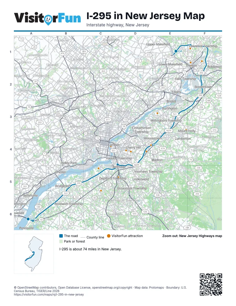
Exits on I-295 in New Jersey
Each exit in mile order, with its grid square.
- Exit 1Amile 1, A6
- Exit 1Bmile 1, A6
- Exit 1mile 1, A6
- Exit 1Cmile 1, A6
- Exit 2Bmile 1, A6
- Exit 2Cmile 2, A6
- Exit 4mile 4, A6
- Exit 7mile 6, A6
- Exit 10mile 10, B5
- Exit 11Amile 11, B5
- Exit 11Bmile 11, B5
- Exit 11mile 11, B5
- Exit 13mile 14, B5
- Exit 15mile 15, B5
- Exit 16Amile 15, B5
- Exit 16Bmile 16, B5
- Exit 17mile 17, C5
- Exit 18mile 17, C5
- Exit 19mile 19, C5
- Exit 20mile 20, C5
- Exit 21-22mile 21, C5
- Exit 21mile 21, C5
- Exit 22mile 22, C5
- Exit 23mile 23, C5
- Exit 24Amile 24, C5
- Exit 24Bmile 24, C5
- Exit 25Amile 24, C5
- Exit 25Bmile 25, C5
- Exit 26mile 25, C5
- Exit 27Amile 26, D5
- Exit 14mile 26, D5
- Exit 28mile 27, D5
- Exit 29Amile 29, D4
- Exit 29Bmile 29, D4
- Exit 29mile 29, D4
- Exit 30mile 29, D4
- Exit 31mile 30, D4
- Exit 32mile 31, D4
- Exit 34Amile 33, D4
- Exit 34Bmile 34, D4
- Exit 36Amile 35, D4
- Exit 36Bmile 35, D4
- Exit 40Amile 39, E4
- Exit 40Bmile 39, E4
- Exit 40mile 39, E4
- Exit 43Amile 41, E3
- Exit 43mile 41, E3
- Exit 43Bmile 42, E3
- Exit 45A-Bmile 43, E3
- Exit 45Amile 43, E3
- Exit 45Bmile 43, E3
- Exit 47Amile 46, E3
- Exit 47Bmile 46, E3
- Exit 52Amile 50, F3
- Exit 52Bmile 51, F3
- Exit 56mile 54, F2
- Exit 57mile 55, F2
- Exit 57B-Amile 55, F2
- Exit 60mile 58, F2
- Exit 60B-Amile 59, F2
- Exit 61Amile 59, F2
- Exit 61Bmile 59, F2
- Exit 62mile 60, F2
- Exit 63A-Bmile 62, F1
- Exit 63mile 62, F1
- Exit 64mile 62, F1
- Exit 65Amile 63, F1
- Exit 65Bmile 63, F1
- Exit 65B-Amile 64, F1
- Exit 67A-Bmile 65, F1
- Exit 67mile 66, F1
- Exit 68Amile 66, F1
- Exit 68Bmile 67, F1
- Exit 69Amile 67, F1
- Exit 69Bmile 67, F1
- Exit 71Amile 68, F1
- Exit 71Bmile 69, F1
- Exit 72mile 70, E1
- Exit 73A-Bmile 71, E1
- Exit 73B-Amile 72, E1
- Exit 75mile 73, E1
- Exit 76mile 74, E1
Highways I-295 meets
Each highway it meets and the grid squares where they meet.
- US 40A6
- US 130A6, B5, F2
- NJ 140A6
- NJ 40A6
- NJ 602B6
- US 322B5
- NJ 44C5
- NJ 45C5
- NJ 47C5
- I-76D5
- NJ 42D5
- NJ 168D5
- US 30D4
- NJ 41D4
- NJ 70D4
- NJ 73D4
- NJ 38E4
- I-95F3
- I-195F2
- NJ 29E1, F2
- NJ 129F2
- US 206F1, F2
- NJ 33F1
- US 1F1
- NJ 31E1
Towns along I-295 in New Jersey
In mile order, with the grid square of each.
- Pennsvillemile 0, A6
- Carneys Pointmile 0, A6
- Pedricktownmile 8, B6
- Beckettmile 9, B6
- Bridgeportmile 13, B5
- Gibbstownmile 14, B5
- Mickletonmile 16, B5
- Paulsboromile 17, C5
- Mount Royalmile 18, C5
- Thorofaremile 20, C5
- Woodburymile 21, C5
- National Parkmile 22, C5
- Westvillemile 24, C5
- Brooklawnmile 24, C5
- Bellmawrmile 25, C5
- Gloucester Citymile 26, D5
- Runnemedemile 26, D5
- Mount Ephraimmile 26, D5
- Audubonmile 27, D5
- Haddon Heightsmile 27, D5
- Barringtonmile 28, D4
- Haddonfieldmile 29, D4
- Magnoliamile 29, D4
- Lawnsidemile 29, D4
- Tavistockmile 30, D4
- Ashlandmile 30, D4
- Springdalemile 31, D4
- Barclaymile 32, D4
- Greentreemile 33, D4
- Ellisburgmile 33, D4
- Kingston Estatesmile 33, D4
- Cherry Hill Mallmile 34, D4
- Ramblewoodmile 34, D4
- Moorestown-Lenolamile 36, D4
- Fieldsboromile 54, F2
- Bordentownmile 56, F2
- White Horsemile 58, F2
- Yardvillemile 58, F2
- Mercervillemile 61, F1
- Lawrencevillemile 67, F1
Things to do on the I-295 in New Jersey map
© OpenStreetMap contributors, Open Database License, openstreetmap.org/copyright · Map data: Protomaps · Boundary: U.S. Census Bureau, TIGER/Line 2026















