

New Jersey road map
New Jersey highway map
10 Interstate routes run about 407 miles in New Jersey, each on a sheet of its own. The sheet's index lists 72 highways; US 206, I-295 and US 9 cross the most grid squares. Towns on it: Newark, Paterson and Lakewood.
Open the map (PDF, US Letter)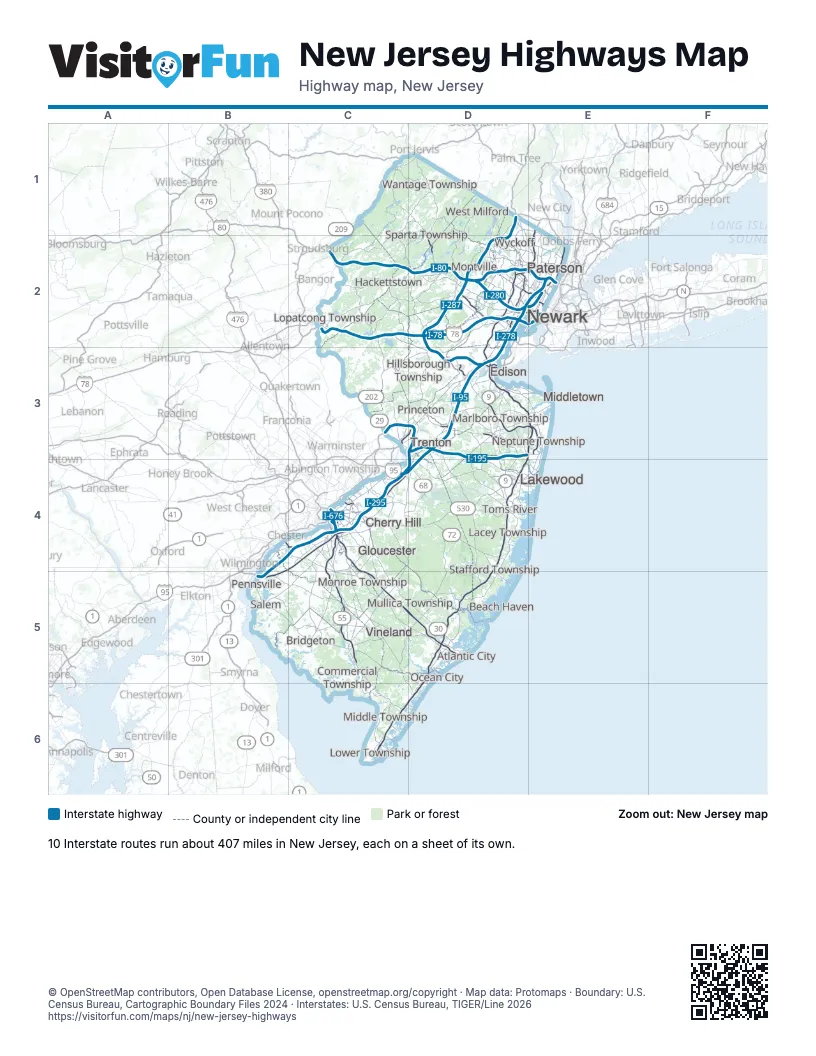
Road maps of New Jersey
15 road maps: each Interstate and byway on a sheet of its own.
- I-76 in New Jersey
- I-78 in New Jersey
- I-80 in New Jersey
- I-95 in New Jersey
- I-195 in New Jersey
- I-278 in New Jersey
- I-280 in New Jersey
- I-287 in New Jersey
- I-295 in New Jersey
- I-676 in New Jersey
- Bayshore Heritage Byway
- Delaware River Scenic Byway
- Millstone Valley Scenic Byway
- Pine Barrens Byway
- Western Highlands Scenic Byway
Highway index of New Jersey
Each highway on the sheet and the grid squares it crosses.
- I-76C4
- I-78C2, D2, E2
- I-80C2, D2, E2
- I-95C4, D2, D3, D4, E2
- I-195D3
- I-278D2
- I-280D2
- I-287D1, D2, D3
- I-295B4, B5, C3, C4, D3, D4
- I-676C4
- US 1C3, D2, D3, E2
- US 9C6, D2, D3, D4, D5, E2
- US 9WE2
- US 22C2, D2, D3
- US 30C4, C5, D5
- US 40B5, C5, D5
- US 46C2, D2, E2
- US 130B4, C4, D3, D4
- US 202C3, D2, D3
- US 206C1, C2, C3, C4, C5, D1, D2, D3, D4
- US 322B4, C4, C5, D5
- NJ 3D2, E2
- NJ 4E2
- NJ 7E2
- NJ 10D2
- NJ 15D1, D2
- NJ 17D1, D2, E2
- NJ 18D3, E3
- NJ 19D2
- NJ 20D2
- NJ 21D2
- NJ 23D1, D2
- NJ 24D2
- NJ 29C3, D3
- NJ 31C2, C3
- NJ 33D3, E3
- NJ 34D3, E3, E4
- NJ 35D3, E3, E4
- NJ 36D3, E3
- NJ 37D4, E4
- NJ 38C4
- NJ 42C4, C5
- NJ 45C5
- NJ 47C5, C6
- NJ 49B5, C5
- NJ 50C5
- NJ 54C5
- NJ 55C4, C5
- NJ 66D3, E3
- NJ 68D4
- NJ 70C4, D4, E4
- NJ 71E3
- NJ 72D4, D5
- NJ 73C4, C5
- NJ 81D2
- NJ 90C4
- NJ 94C1, D1
- NJ 109C6
- NJ 120E2
- NJ 129C3
- NJ 133D3
- NJ 138D3, E3
- NJ 139E2
- NJ 140B5
- NJ 173C2
- NJ 179C3
- NJ 208D2, E2
- NJ 347C5, C6
- NJ 413C4
- NJ 440D2, D3, E2
- NJ 495E2
- PA 611C2, C3
Places on the map
- Atlantic City
- Beach Haven
- Bridgeton
- Cherry Hill
- Commercial Township
- Edison
- Gloucester
- Hackettstown
- Hillsborough Township
- Lacey Township
- Lakewood
- Lopatcong Township
- Lower Township
- Marlboro Township
- Middle Township
- Middletown
- Monroe Township
- Montville
- Mullica Township
- Neptune Township
- Newark
- Ocean City
- Paterson
- Pennsville
- Princeton
- Salem
- Sparta Township
- Stafford Township
- Toms River
- Trenton
- Vineland
- Wantage Township
- West Milford
- Wyckoff
© OpenStreetMap contributors, Open Database License, openstreetmap.org/copyright · Map data: Protomaps · Boundary: U.S. Census Bureau, Cartographic Boundary Files 2024 · Interstates: U.S. Census Bureau, TIGER/Line 2026















