

New Mexico map
Alamogordo map
About 31,667 people live here (Census Bureau, 2024 estimate). The sheet's index lists 300 streets; Charlie Lee Memorial Relief Route, North White Sands Boulevard and North Scenic Drive cross the most grid squares. Things to do inside the boundary: McGinn's PistachioLand.
Open the map (PDF, US Letter)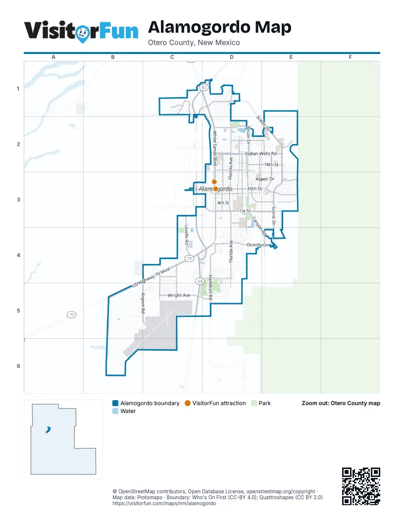
Street index of Alamogordo
Each street on the sheet and the grid squares it crosses.
- Charlie Lee Memorial Relief RouteC1, C2, C3, C4, D4
- North White Sands BoulevardC1, D1, D2, D3
- US Highway 70 WestB4, C4, B5
- US Highway 54 SouthC4, C5
- South White Sands BoulevardD3, C4, D4
- US Highway 82C1, D1
- Three FlowersC4, D4
- North Scenic DriveC1, D1, E2, E3
- Indian Wells RoadD2, E2
- East 1st StreetD3, E3
- North Florida AvenueD1, D2, D3
- East 10th StreetD3, E3
- South Florida AvenueD3, D4, D5
- Hamilton RoadD4, D5
- North Washington AvenueD2, D3
- South Scenic DriveE3, E4
- Mesa Verde Ranch RoadC1
- Pecan DriveD2
- Wright AvenueC5
- Panorama BoulevardD4
- South Walker AvenueC4, C5
- Fairgrounds RoadD2
- West 10th StreetC3, D3
- Desert Lakes RoadD4
- West 1st StreetD3
- East Dr Martin Luther King Jr DriveC5, D5
- Alamogordo DriveC3
- Juniper DriveE2, E3
- Cuba AvenueD2, D3
- Puerto Rico AvenueD2, D3
- Airport RoadB4, C4, C5
- 18th StreetD2, E2
- East 8th StreetD3
- Lavelle RoadC3, C4
- College AvenueD2, D3
- South Canyon RoadD3, D4, E4
- Abbott AvenueD3, E3
- East 16th StreetD2
- 25th StreetD2, E2
- Ocotillo DriveD4, E4
- Indiana AvenueD2, D3
- Collins AvenueC4, C5
- East Canal StreetD2
- South Washington AvenueD3, D4
- Maryland AvenueD3
- Madison AvenueD3
- Mesa Village DriveC1
- Thunder RoadE3
- Cornell AvenueE2
- Mescalero StreetC4
- Red Arroyo DriveC1
- McDonald RoadC3
- Santa Cruz DriveD3
- Highway 2001E2
- Questa DriveC1
- West Canal StreetD2
- Oregon AvenueD2, D3
- 15th StreetD3, E3
- Alaska AvenueD2, D3
- Hawaii AvenueD2, D3
- East 12th StreetD3, E3
- 24th StreetD2, E2
- 7th StreetD3
- East 9th StreetD3
- Post AvenueC5
- Lindberg AvenueC5
- Dewey LaneD2, E2
- 13th StreetD3
- Caneadea LoopD4
- Sunrise AvenueE3
- Bellamah DriveD3, E3
- 14th StreetD3
- Airport AvenueC5
- Crescent DriveE2, E3
- Catalina LaneD2
- Eagle DriveD4, D5
- 4th StreetD3, E3
- Business Center BoulevardB5, C5
- Aspen DriveD3, E3
- Lovers LaneD2
- 23rd StreetD2, E2
- Arizona AvenueE2, E3
- Spruce AvenueD3, E3
- Jefferson AvenueD2, D3
- 5th StreetD3
- Delaware AvenueD3
- Virginia AvenueD3
- Texas AvenueD3
- North New York AvenueD3
- East 11th StreetD3
- Ridgecrest DriveE3
- Utah AvenueD2, D3
- Brooks AvenueC5
- Mountain View AvenueD3
- Kerry AvenueD4
- Las LomasD4
- Bluemont RoadB5, C5
- Mill RoadD2, D3
- Wood LoopD1
- Monroe AvenueD3
- 3rd StreetD3
- Iowa AvenueD2, D3
- 2nd StreetD3
- 19th StreetD2, E2
- Robert H Bradley DriveD1, D2
- Mimosa AvenueD4
- Mayflower RoadC4
- Zuni DriveC4
- Michigan AvenueD2, D3
- New York AvenueD2, D3
- Vermont AvenueD2, D3
- Mc Kinley AvenueE3
- Filipino AvenueD3
- Adams AvenueD3
- Bonnell DriveE3
- Stanford AvenueD2
- West 8th StreetC3, D3
- San Miguel StreetD4
- Park AvenueE2, E3
- Tres LagosD4, D5
- Railroad AvenueD3
- Paradise AvenueC5
- Mesquite StreetC4
- Municipal AvenueC5
- Ohio AvenueD2, D3
- 26th StreetD2
- Eddy DriveD2, D3
- Lawrence BoulevardD2
- Byrd AvenueC5
- Stapp AvenueC5
- Earhart AvenueC5
- San Carlos StreetD4
- Cottonwood DriveD1
- Union AvenueE2
- Birdie LoopD5
- 6th StreetD3
- Hendrix AvenueE3
- Mercury AvenueD4
- Apache LaneE2, E3
- Basswood DriveD1
- Palo DuroD5
- Glacier DriveD1
- Canyon PlaceE4
- Calle Verde DriveC1
- Pontiac DriveE2
- Arapaho TrailD3, D4
- BosqueD5
- RockwoodE2, E3
- Tiger DriveD3
- Adobe Ranch TrailE3
- GranadaE2, E3
- Holly AvenueC4, C5
- Lackland AvenueC5
- Cotton AvenueD3
- Hopi TrailE3
- Columbia AvenueC5
- Medical DriveE2
- Los RoblesE2
- Tierra de SuenosD4
- Hermoso El SolD4
- Shawnee TrailE3
- Tierra BellaD1
- Snow DriveD2, E2
- West 16th StreetD2
- Cherokee TrailE3
- Challenger AvenueC5
- Roosevelt AvenueD2, D3
- Lawndale AvenueD3
- Desert Hills DriveD4, D5
- Tulane AvenueD2, E2
- Harvard AvenueD2
- Sundial AvenueE3
- Canal Trailer ParkD2
- Yale AvenueD2
- Greenwood LaneD2
- Paiute TrailE3
- Grant StreetC3
- Discovery AvenueC5
- Del SurE3
- Driftwood AvenueD1
- Rosewood AvenueD1
- Fernwood AvenueD1
- Acacia AvenueC1
- Mesa LaneE2
- Cameo RealD4
- Biggs AvenueC5
- Travis AvenueC5
- Escondido DriveC1
- Champion WayE2
- Winterhaven RoadC3
- Plainview DriveD3
- Cielo GrandeD4
- Del PradoE2
- Alta Vista DriveD3
- Cherry Hills DriveD4, D5
- Oakmont DriveD5
- Ocotillo LaneD4
- Baylor AvenueD2
- Crews AvenueE3
- Dale Scott AvenueD3
- Brookdale DriveD4
- Corte AlegreD2
- Maple DriveE3
- Buena Vista CorteE2
- Sherwood DriveD3
- Fayne LaneD1, D2
- Corte del SolD2
- Lamar CircleE2
- Van CourtD2
- Las Alturas CourtE3
- Corte del RancheroD2
- Evergreen Trailer Park 1-80D2
- Monte Vista CorteD2
- Princeton AvenueD2
- Cielo VistaD4
- Desert Eve DriveD2
- Santa Fe DriveD3
- ValenciaD4
- Casa de SuenosD4
- El DoradoE2
- Black StreetC4
- Hunters RidgeD4
- Summer AvenueE3
- Larkspur StreetD4
- Venus AvenueD4
- San Simon DriveD1
- Enterprise AvenueC5
- Moonglow AvenueE3
- AlexC4
- Avenida AmigosD3
- Carmel DriveE2
- Cedar AvenueE3
- Nevada DriveE2
- Desert Dawn DriveD2
- Mosswood AvenueD1
- Santiago StreetD4
- Westminister AvenueD2
- Comanche TrailE3
- Evergreen Trialer Park 81-141D2
- Kelley AvenueC5
- Ironwood DriveD1
- Arnold LaneD2
- Coronado DriveD3
- Saguaro LoopD4, D5
- Divers CoveD4
- Hubbard DriveD2
- Arroyo SecoD4
- West 12th StreetC3, D3
- Sierra VerdeD4
- Cambridge AvenueD2
- Tesuque DriveC1
- Wyatt WayE2
- Zia AvenueE3
- Montecito DriveD1
- Sunland DriveE3
- Brentwood DriveD1
- Wildwood DriveD1
- Eudora StreetD2
- Pine DriveE3
- South New York AvenueD3
- Anna MaryC4
- Chicory DriveC1
- NancyC4
- Jackson AvenueD3
- Del CerroE3
- Fillmore AvenueD3
- Sunglow AvenueE3
- North Walker StreetC4
- SilveradoD4
- San Andres StreetD2
- Sunnyside AvenueE3
- Eastridge DriveE3
- Uranus DriveD4
- Sequoia AvenueD1, D2
- Sunbeam AvenueE3
- Playa Del Ray DriveD1
- Sunset AvenueE3
- Sunshine AvenueE3
- Las Lomas CourtD4
- Linda Vista DriveD2
- Walnut DriveD2
- Boyce AvenueE3
- Plaza del PradoE2, E3
- Sequoia LoopD1
- Shadow Mount DriveE3
- Sundown AvenueE3
- Desert Gold Trailer ParkC4
- Dulce DriveB6
- Two Hearts Trailer ParkD2
- BandolierD2
- D&E trailer parkC4
- Rolland AvenueE3
- James StreetC4
- Dexter LaneD2
- Marketplace DriveC1, D1
- Martin BoulevardD1
- Trawood DriveD1
- Kingston DriveD4
- Cameo DriveD4
- Cauthen LaneD2
Things to do on the Alamogordo map
Places on the map
- 1 Stop Auto
- 1ST Street Carpet and Tile
- 84 Lumber
- Aaron's
- Ace Motel
- Airgas
- Alameda Park
- Alameda Park Zoo
- Alamo Auto Parts
- Alamo Inn Motel
- Alamo Mini Storage
- Alamo Senior Center
- Alamogordo / White Sands KOA
- Alamogordo Community Garden
- Alamogordo Fire Station #1
- Alamogordo Fire Station #4
- Alamogordo Fire Station #5
- Alamogordo High School
- Balloon Park
- Bethel Baptist Church
- Casa Chrysler Dodge Jeep RAM
- Chaparral Middle School
- CHRISTUS Health Alamogordo
- Desert Foothills Park
- Desert Lakes Golf Course
- Desert Star Elementary School
- Granada Shopping Center
- Griggs Field Detention Basin
- Heights Elementary School
- Jim R. Griggs Sports Complex
- Just Store-It Self Storage
- Monte Vista Cemetery
- Mountain View Middle School
- Otero County Detention Center
- Otero County Fairgrounds
- Saint Jude Catholic Church
- Washington Detention Basin
- Washington Park
- White Sands Mall
© OpenStreetMap contributors, Open Database License, openstreetmap.org/copyright · Map data: Protomaps · Boundary: Who's On First (CC-BY 4.0); Quattroshapes (CC BY 2.0)















