

New Mexico map
Otero County map
About 69,711 people live here (Census Bureau, 2024 estimate). The sheet's index lists 300 streets; Dog Canyon Road, US Highway 82 and Main Street cross the most grid squares. Things to do inside the boundary: White Sands National Park, Alamogordo and Inn of the Mountain Gods Resort & Casino.
Open the map (PDF, US Letter)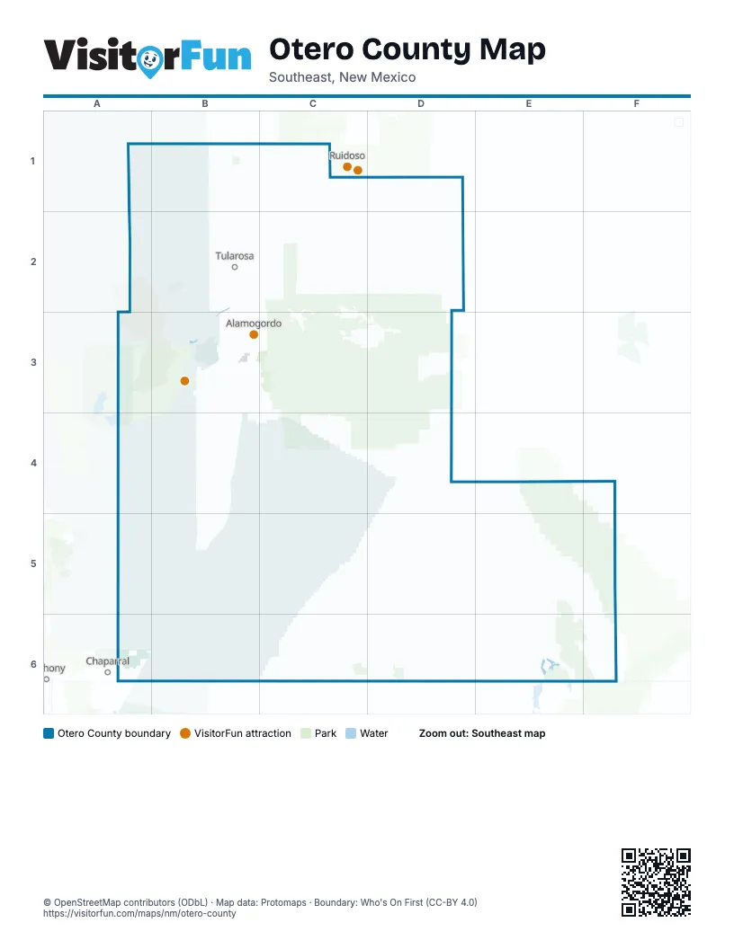
Maps inside Otero County
1 map inside, from the street map of Otero County down.
Street index of Otero County
Each street on the sheet and the grid squares it crosses.
- US Highway 70 WestB3, A4, B4
- US Highway 54 SouthB3, B4, B5
- US Highway 54B5, A6, B6
- US Highway 82B2, C2, B3, C3, D3
- NM 244C2, D2
- Charlie Lee Memorial Relief RouteB3
- North White Sands BoulevardB3
- Central AvenueB2
- Saint Francis DriveB2
- South White Sands BoulevardB3
- Main StreetB2, C2, D3, B5
- James Canyon HighwayC2
- Grand BoulevardC2, C3
- Three FlowersB3
- Gateway South BoulevardA6
- Gateway North BoulevardA6
- Dog Canyon RoadB3, C3, D3, E5, F5, F6
- Cox Canyon HighwayC2, C3, D3
- Indian Service Rt 10C2
- La Luz Gate RoadB2, B3
- North Scenic DriveB3, C3
- Laborcita Canyon RoadB2, C2
- Riata RoadB2
- White Mountain DriveC1, C2
- Cox Canyon Highway / Rio Penasco RoadD3
- North Florida AvenueB2, C2, B3, C3
- Douglas RoadB3
- Carrizo Canyon RoadC1
- Indian Wells RoadB3, C3
- Railroad AvenueB2, B3, C3
- East 1st StreetB3, C3
- White Sands Missile Range S Route 264A4
- Hamilton RoadB3
- Mesa Verde Ranch RoadB3
- Rio Penasco RoadD3
- North Bookout RoadB2
- 1st StreetB2, C2, B3
- East 10th StreetB3, C3
- Indian Service Rt 6C1
- Alamo StreetB2, C2
- South Florida AvenueB3
- Sabre RoadB3
- Alamogordo DriveB3
- Mescalero BoulevardC2
- South Scenic DriveC3
- Old RoadC2
- North Washington AvenueB3
- Old Mescalero RoadB2
- Pecan DriveB2, B3, C3
- Fairgrounds RoadB3, C3
- La Luz RoadC2
- Higuera AvenueB2
- West 10th StreetB2, B3
- Eagle DriveC2, B3
- Botella RoadC1
- Wright AvenueB3
- South Bookout RoadB2
- Panorama BoulevardB3
- South Walker AvenueB3
- East Delaware AvenueB3
- Desert Lakes RoadB3
- West 1st StreetB2, B3
- West 11th StreetB2, B3
- West Delaware AvenueB3
- West Gate AvenueB3
- Radio RoadB2
- Apache BoulevardC2
- Yucca DriveB2, C2
- Bookout RoadB2
- East Dr Martin Luther King Jr DriveB3
- Apache AvenueC2
- Dollar ParkwayB2
- Pinon Dunken RoadD4
- White Sands Missile Range P Route 9A1, B1, B2
- Agua Chiquita RoadC3, D3
- County Road E038D4, D5, E5
- Wsmr P Rt 9B2, B3
- White Sands Missile Range P Route 15A4, A5
- White Sands Missile Range P Route 2A5, B5
- Wsmr P Rt 6A2, B2
- Sunspot HighwayC3
- Sacramento Canyon RoadC3, C4
- Coyote Canyon RoadB2, C2
- 16 Springs Canyon RoadD2
- Wsmr P Rt 10A3, B3
- Indian Service Rt 1C2
- Three Rivers RoadB1, C1
- White Sands Missile Range S Route 202A4, B4, A5
- Sixteen Springs Canyon RoadC2, D2, C3
- White Sands Missile Range P Route 17B1, A2, B2
- County Road G007E5
- Carr Gapp RoadD2
- Indian Service Rt 11C1, C2
- Indian Service Route 3D1, D2
- Hueco Camp RoadA6
- Dunes DriveB3
- Wsmr P Rt 21A4
- M2D2
- Taylor Ranch RoadB3
- Benson Ridge South RoadC2, C3
- Owen Prather HighwayB4, D4
- Nogal Canyon RoadC2
- Angelina BoulevardA6
- Indian Service Rt 3C1, D1, D2
- Elk Canyon RoadD2
- Luna DriveA6
- Fence Canyon RoadC1
- Kelly RoadB3
- Mountain Meadows RoadB2
- Dry Burnt Canyon RoadD2, D3
- Tulie Gate RoadB2
- M25D1, D2
- Karr Canyon RoadC3
- Walker Canyon RoadD2, D3
- State Line DriveA6
- Haynes Canyon RoadC3
- Carr Gap RoadD2, D3
- White Sands Missile Range P Route 3A5
- White Sands Missile Range Route 316A1
- Alamotero LaneB3
- Derbyshire RoadB2
- Loop DriveB3
- 7th StreetB2, B3, C3
- Jose Second Canyon RoadC1
- Indian Service Rt 2D2
- Forty Niner AvenueB3
- County Road G005E6
- South Canyon RoadC3
- Penn Scott DriveC1
- Juniper DriveC2, C3
- Indian Service Rt 25C1
- 2nd StreetB2, C2, B3, C3
- Route 175D2
- Fs 607D3
- Oliver RoadB3
- Rattlesnake RoadB2
- Dezonia RoadB3
- San Pedro DriveB3
- Cuba AvenueB3
- Old el Paso HighwayB3
- County Road B037B1
- Puerto Rico AvenueB3
- Arizona AvenueB3, C3
- West Side RoadC3
- Dog Ranch RoadB2
- Appler RoadB2
- Santa Fe DriveB3, C4
- Thunder RoadC3
- Lavelle RoadB3
- Chatto DriveC1
- Airport RoadB3
- 18th StreetB3, C3
- 5th StreetB2, B3, C3
- East 8th StreetB3, C3
- School RoadB3
- Sun Valley RoadB2
- Carr Gap Canyon RoadD3
- College AvenueC3
- Monte Vista AvenueB2, A6
- Section RoadC2
- Southend RoadB3
- Santa Cruz DriveB3, A6
- Pollen LoopC2
- Abbott AvenueC3
- Eddy DriveB3
- East 16th StreetB3, C3
- Ocotillo DriveB3, C3
- 25th StreetB3, C3
- Northwest Bookout RoadB2
- Indiana AvenueB3
- Quail TrailB3
- La Luz AvenueB2
- Sari RoadB3
- Smith AvenueB3
- Indian Service Rt 21C1
- Collins AvenueB3
- Old Railroad DriveC3
- K C RoadB3
- Sabinata LaneB2
- East Canal StreetB3
- Bent RoadC2
- McDonald RoadB3
- Boles AvenueB3
- Alamogordo BoulevardB3
- Fresnal Canyon RoadC2, C3
- South Washington AvenueB3
- Mountain Park RoadC3
- Maryland AvenueB3
- Madison AvenueC3
- County Road G025E5
- J J Henry RoadB2
- MatthewsB3
- 8th StreetB2, C3
- Mesa Village DriveB3
- Rose StreetB2, B3
- Creosote AvenueB3
- Cornell AvenueC3
- Patterson DriveB3
- Lipan AvenueC2
- Mescalero StreetB3
- Red Arroyo DriveB3
- Cottage RowC3
- South Tularosa Canyon RoadC2
- Arnold AvenueB3
- Old Firehouse RoadC3
- Encino StreetB2
- Bosque StreetB2
- Highway 2001C3
- Gallerito Flats RoadC2
- Frontage RoadB3
- Questa DriveB3
- Indian Service Rt 72C1
- Chato DriveC1
- West Canal StreetB3
- Posey LaneB2
- Utter LaneB2
- Cherry BlossomC3
- Brittany LaneB2
- County Line DriveA6
- Rim TrailC3
- Simon LaneB3
- Lopez LaneB2
- Wildcat Turf DriveB2
- Marshall AvenueB2
- Boles RoadB3
- B-012B2
- M72C1
- RoundaboutB3
- A-069B2
- Cornucopia Canyon RoadD4
- Guadalupe Rim RoadE4, E5, F5
- Indian Service Route 31D1, D2
- Indian Service Route 14C2, D2
- County Road G013E5, E6, F6
- Dell City RoadD6, F6
- Indian Service Route 12D2
- County Road F026D6
- County Road G008E5, E6
- County Road F034C5, C6
- County Road F010C6, D6
- County Road F001D5, B6, D6
- County Road F041D5, D6
- County Road F022D6
- County Road F003C6
- La Luz Canyon RoadC2
- Upper Rio Penasco RoadC3, D3
- County Road G004E5, D6, E6
- County Road G002D6, E6
- Hay Canyon RoadC3, D3
- County Road G001D6, E6
- County Road F054C5, C6
- County Road F046D5
- County Road E027E4, D5, E5
- F-065D6, E6
- Perk Canyon RoadC3, D3
- County Road F065D6, E6
- Camera Pad RoadB2, B3
- Miller Flats RoadD3
- County Road E025D4, E4, D5
- Anderson RoadE4, F4, E5
- County Road F028D6
- County Road F036C5, D5
- F-003C6
- Jim Lewis Canyon RoadC3, D3, C4, D4
- County Road F019D6
- Wills Canyon RoadC3
- Pinon Draw RoadE4, E5
- Box CanyonE5
- Indian Service Route 33D1, D2
- County Road F031C6
- Sacramento River RoadC4, D4
- Indian Service Route 59D2
- Pumphouse RoadC3
- Indian Service Rt 77D2
- White Sands Missile Range S Route 252B4, B5
- F-040D5, D6
- Curtis Canyon RoadD3
- Old Las Cruces HighwayB3, B4
- Chimney Lake RoadD3, D4
- County Road F048D5
- Indian Service Rt 22C1
- County Road F011D6
- Dark Canyon RoadC3
- Indian Service Rt 47C2
- County Road F032D5, C6, D6
- Weed RoadD3
- County Road E001D4
- County Road F007C6, D6
- County Road F004C6
- Indian Service Route 56D2
- County Road F069D5
- Indian Service Rt 17C2
- County Road F029D6
- Potato Canyon RoadC3
- M3D2
- Pendleton Canyon RoadD3
- County Road F033C5, C6, D6
- County Road F014D6
- County Road F058C5
- County Road E028D5
Things to do on the Otero County map
Places on the map
- Alamo Mountain Area of Critical Environmental Concern
- Alamogordo
- Alamogordo High School
- Alamogordo RCers
- Alkali Lakes Area of Critical Environmental Concern
- Atkinson Field
- Backcountry Camping Trail
- Boles Acres
- Brokeoff Mountains Wilderness Study Area
- Camp Tall Pines
- Carrizozo Volcanic Field
- Cemex Sally Walker Quarry
- CHRISTUS Health Alamogordo
- Cloudcroft
- Desert Foothills Park
- Desert Lakes Golf Course
- Fort Bliss
- Gray Eagle UAS Complex
- Griggs Field Detention Basin
- HELSTF
- Holloman Air Force Base
- La Luz
- Loop Drive
- Main Ramp
- McGregor
- McGregor Range
- Mescalero
- Mescalero Lake
- Oilver Lee Memorial State Park
- Otero County Landfill
- Ponderosa Pines Golf Course
- Sacramento Escarpment Area of Critical Environmental Concern
- Ski Cloudcroft
- Three Rivers Petroglyph Site
- Timberon
- Timberon Golf Course
- Tularosa
- White Sands
- White Sands National Monument
- White Sands National Park
Next to Otero County
- Anthony
- Chaparral
- Ruidoso
© OpenStreetMap contributors, Open Database License, openstreetmap.org/copyright · Map data: Protomaps · Boundary: Who's On First (CC-BY 4.0); Quattroshapes (CC BY 2.0)















