

New Mexico road map
I-10 in New Mexico map
I-10 is about 163 miles in New Mexico. It has 32 exits, from Exit 3 at mile 3 to Exit 0 at mile 163. It meets 21 highways; US 70, US 180 and NM 418 meet it in the most grid squares.
Open the map (PDF, US Letter)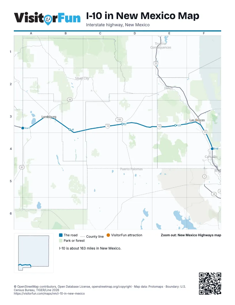
Exits on I-10 in New Mexico
Each exit in mile order, with its grid square.
- Exit 3mile 3, A3
- Exit 5mile 5, A3
- Exit 11mile 11, A3
- Exit 15mile 16, A3
- Exit 20Amile 20, A3
- Exit 20mile 21, A3
- Exit 22mile 22, A3
- Exit 24mile 24, B3
- Exit 29mile 29, B3
- Exit 34mile 34, B3
- Exit 42mile 42, B3
- Exit 49mile 49, B3
- Exit 55mile 55, C3
- Exit 62mile 63, C3
- Exit 68mile 68, C3
- Exit 81mile 81, D3
- Exit 82Amile 81, D3
- Exit 82Bmile 83, D3
- Exit 85mile 84, D3
- Exit 102, Akelamile 102, D3
- Exit 116mile 115, E3
- Exit 127mile 126, E3
- Exit 132mile 131, E3
- Exit 135mile 134, F3
- Exit 139mile 139, F3
- Exit 140mile 140, F3
- Exit 142mile 141, F3
- Exit 144mile 144, F3
- Exit 151mile 151, F4
- Exit 155mile 154, F4
- Exit 162mile 162, F4
- Exit 0mile 163, F4
Highways I-10 meets
Each highway it meets and the grid squares where they meet.
- NM 80A3
- NM 338A3
- US 70A3, B3, C3, D3, E3, F3
- NM 494A3
- NM 146B3
- NM 418C3, D3
- NM 549D3, E3
- US 180D3, E3, F3, F4
- NM 11D3
- NM 292F3
- NM 28F3
- NM 101F3
- NM 188F3
- NM 478F3
- NM 138F3
- I-25F3
- US 85F3, F4
- NM 228F4
- NM 227F4
- NM 460F4
- NM 404F4
Towns along I-10 in New Mexico
In mile order, with the grid square of each.
- Lordsburgmile 20, A3
- Demingmile 80, D3
- Keeler Farmmile 82, D3
- Venturamile 86, D3
- Las Crucesmile 129, E3
- Fairacresmile 136, F3
- Mesillamile 137, F3
- University Parkmile 142, F3
- San Pablomile 142, F3
- Mesquitemile 150, F4
- Vadomile 153, F4
- Berinomile 158, F4
- Anthonymile 161, F4
© OpenStreetMap contributors, Open Database License, openstreetmap.org/copyright · Map data: Protomaps · Boundary: U.S. Census Bureau, TIGER/Line 2026