

New Mexico map
Rio Rancho map
About 112,524 people live here (Census Bureau, 2024 estimate). The sheet's index lists 300 streets; Pat D'Arco Highway, Unser Boulevard Northeast and Progress Boulevard Northeast cross the most grid squares. Also on it: AmeriGas, Cabezon Park and Cayenne Loop.
Open the map (PDF, US Letter)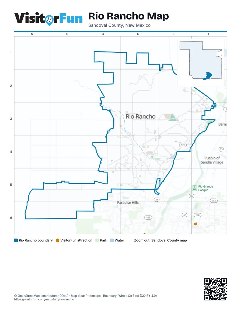
Street index of Rio Rancho
Each street on the sheet and the grid squares it crosses.
- Pat D'Arco HighwayF2, F3, E4, D5, E5
- Unser Boulevard NortheastD2, E2, D3, D4, D5
- Idalia Road NortheastE3, F3, D4, E4
- Paseo del VolcanF2, D3, E3, F3
- Unser Boulevard SoutheastD4, D5
- High Resort Boulevard SoutheastD4, E4
- Unser BoulevardD4, D5
- Quantum Road NortheastE4
- High Resort BoulevardE4
- New Mexico State Road 528E5
- Rio Rancho Boulevard NortheastF3
- Northern Boulevard NortheastC4, D4, E4
- Southern Boulevard SoutheastC5, D5, E5
- Enchanted Hills Boulevard NortheastE2, F2, F3
- Cabezon Boulevard SoutheastD5
- Golf Course Road SoutheastD5
- Country Club Drive SoutheastD4, D5
- Northwest Loop Road NortheastE1, E2
- Corrales RoadE4
- Rainbow Boulevard NortheastC2, C3, C4
- Loma Colorado Boulevard NortheastE3, D4, E4
- King Boulevard NortheastC3, D3
- Westside Boulevard SoutheastC5, D5, E5
- Broadmoor Boulevard NortheastD3, D4
- Lincoln Avenue NortheastE3, F3
- Chayote Road NortheastE2, E3, F3
- Camino Encantadas NortheastF2, F3
- Mariposa Parkway NortheastD2
- Cherry Road NortheastC3, D3, D4
- Iris Road NortheastE3, F3
- 17th Avenue NortheastD3, E3, D4
- Pine Road NortheastC3, C4, D4
- Western Hills Drive SoutheastD4, D5
- Abrazo Road NortheastC4, D4
- Tulip Road SoutheastC4, D4
- Westphalia Boulevard NortheastE2, E3
- Kim Road NortheastE3, E4
- Grande Boulevard SoutheastD5, E5
- Rockaway Boulevard NortheastE4
- Meadows Boulevard NortheastC3
- Broadmoor Boulevard SoutheastD4
- Blue Grama Drive NortheastD2
- 10th Street NortheastC3, C4
- Wellspring Avenue SoutheastD5
- Lisbon Avenue SoutheastD4, D5
- Rainbow Boulevard SoutheastC4, C5
- Sara Road SoutheastD5, E5
- Pecos Loop SoutheastC4, C5, D5
- Tarpon Avenue SoutheastD4, D5
- Riverside Drive NortheastF3, F4
- Baltic Avenue SoutheastC4, D4, C5
- 5th Street SoutheastC4, D4, C5
- Northern Boulevard NorthwestC4
- Terraza Boulevard NortheastD4, E4
- Chessman Drive NortheastD4
- Willow Creek Road NortheastF3
- Nicklaus Drive SoutheastD4, D5
- 19th Avenue SoutheastC5, D5, E5
- Meadowlark Lane SoutheastE5
- Amy Road NortheastD3
- Cleveland Heights Road NortheastE3
- Rio Vista Drive NortheastE4
- Santa Fe Hills Boulevard NortheastF2
- Sandia Vista Road NortheastE4, F4
- Montezuma Boulevard NortheastD3, E3
- Honduras Road NortheastE3, F3
- Southern Boulevard SouthwestC5
- Villa Verde Drive SoutheastE4, E5
- Monarch Way NortheastD2
- Sabana Grande Avenue SoutheastE5
- Grande Vista Road NortheastE4
- Leon Grande Avenue SoutheastE4
- Redondo Sierra Vista DriveD2
- Sundt Road NortheastE4
- Arena Drive NortheastD3
- Montreal Loop NortheastF2, F3
- Camino Venada NortheastF3
- Ridgecrest Drive SoutheastE4
- Sandia BoulevardC4
- Safelite Boulevard NortheastF2
- Los Diamantes Drive SoutheastC5
- Champion Road NortheastD3
- Antonia Apodaca Street SouthwestB5
- Western Hills Drive NortheastD4
- Sierra Blanca Road NortheastF3
- Old Unser BoulevardD4
- Mike Judge Street SouthwestB5
- Wexford Road SoutheastD4, D5
- Trail Side Boulevard SoutheastD5
- Center Boulevard NortheastD3
- Trailside Road SoutheastD5
- Mario J. Lucero Avenue NorthwestC3
- Meadowlark Court SoutheastE5
- Civic Center Circle NortheastD3
- HP Way NortheastD3
- Safelite Road NortheastF2
- College Boulevard NortheastD3
- Chessman Drive SoutheastD4
- Goldentail Drive NortheastD2
- West Meadowlark LaneE5
- Apricot Way NortheastD3
- 30th Avenue NortheastD3
- Progress Boulevard NortheastC2, D2, D3, E3, F3
- 19th Avenue SouthwestA5, B5, C5
- 23rd Avenue SouthwestB5, C5
- Inca Road NortheastE3, C4, D4, E4
- Monterrey Road NortheastE3, F3, E4
- Saratoga Drive NortheastE3, E4
- 22nd Avenue SouthwestB5, C5
- 28th Avenue NortheastC3, D3, E3
- 21st Avenue SoutheastC5, D5
- 20th Avenue SouthwestA5, B5, C5
- 16th Avenue SoutheastC5, D5
- Huron Drive NortheastE4
- Acoma Road SouthwestB5
- Wilpett Road NortheastD3
- 8th Street NortheastC4
- 14th Avenue SoutheastC5, D5
- Vatapa Road NortheastE3, F3
- Villa Road SoutheastC5, D5
- 15th Street SoutheastD5
- Calicut Road NortheastD2
- 21st Avenue SouthwestA5, B5, C5
- Chihuahua Road NortheastE3, F3, E4
- 9th Avenue NortheastC4, D4, E4
- Aztec Road SouthwestB5
- Nacelle Road NortheastE3, F3
- 22nd Avenue SoutheastD5
- Sonora Road NortheastE3, F3, E4
- 10th Avenue NortheastC4, D4
- 20th Avenue SoutheastD5
- Lema Road SoutheastD4
- 11th Avenue SoutheastC5, D5
- Barbara Loop SoutheastE5
- Hondo Road NorthwestC4
- Corrales North Bosque Preserve Access RoadE4, F4
- 5th Avenue NortheastC4, D4
- 1st Street NortheastC4
- Vancouver Road SoutheastC4, C5
- Kennard Road NortheastE2
- Roadrunner Loop NortheastE4, F4
- Clearwater Loop NortheastF3
- Pasilla Road NortheastE3, F3
- Sandia Loop NortheastD3, F3
- Pyrite Drive NortheastE4
- 26th Avenue NortheastE3
- Nez Perce Loop NortheastE3, E4
- Saint Andrew's Drive SoutheastD4, E4
- 15th Avenue SoutheastC5, D5
- Nagoya Road NortheastF3
- Kodiak Road NortheastF3
- Ivory Road SoutheastD4, D5
- 19th Street SoutheastD4, D5
- Fulcrum Way NortheastF2, F3
- Apache Loop SouthwestC4, C5
- Manzano Loop NortheastF3
- Kalgan Road NortheastE3, F3
- 25th Avenue NortheastC3, D3, E3
- Springer Drive NortheastE2, F2
- Nambe Road NortheastE2
- 2nd Street NortheastC4
- 3rd Street NorthwestC4
- 2nd Street SoutheastC4, D4
- Sioux Drive NortheastE4
- Acorn Loop NortheastC4, D4
- Inca Road SoutheastC4
- Wagon Train Drive SoutheastD4, D5
- 18th Avenue SoutheastC5, D5
- Violeta Circle SoutheastD5
- Sandia Boulevard NortheastC4
- Oersted Road NortheastE3, F3
- Alberto Avenue NortheastE4
- Reynosa Loop SoutheastD5
- 32nd Circle SoutheastD5, E5
- 10th Street SoutheastC5
- Hondo Road SouthwestC4, C5
- Edinburgh Street NortheastD4
- 3rd Street SoutheastC4, C5
- 6th Street NortheastC4
- 4th Street NortheastC4
- 5th Street NortheastC4
- 9th Street NortheastC4
- 3rd Street NortheastC4
- 7th Street NortheastC4
- Ann Circle SoutheastD5, E5
- Oakmount Drive SoutheastD4, D5, E5
- Augusta Hills Drive NortheastF2
- Patchogue Road NortheastD2
- Spur Road SoutheastC5, D5
- Oasis Springs Road NortheastD3
- Gros Ventre Drive NortheastE3, E4
- Bombay Road NortheastD2, D3
- 9th Avenue NorthwestC4
- Acapulco Road NortheastE4
- Frontage Road NortheastE4
- Old Highway 44E2
- 27th Avenue NortheastE3
- 10th Avenue NorthwestC4
- Asbury Road NortheastE4
- Camino de Los Montoyas Road NortheastC3, D3
- Alif Road NortheastE3, E4
- Viga Road SoutheastC5, D5
- Palmas Altas Drive SoutheastE4, E5
- Leeds Castle Avenue NortheastD4
- Mountain Trail Loop NortheastF2, F3
- 17th Avenue SoutheastC5, D5
- 33rd Circle SoutheastD5, E5
- Wolf Tail Loop NortheastD2
- 8th Avenue NorthwestC4
- Mountain Hawk Loop NortheastE2
- Summer Winds Drive SoutheastD4
- Dolores Huerta Street SouthwestB5
- 12th Avenue SoutheastC5, D5
- Venture Drive NorthwestC2, C3
- Arkansas Street SoutheastC4, D4
- 7th Avenue NorthwestC4
- Calle Sueños SoutheastD4
- Vista de Colinas Drive SoutheastD5
- Fruta Road NortheastD4
- Skyline Loop NortheastE3
- 6th Avenue NorthwestC4
- Littler Drive SoutheastD4, D5
- Colorado Mountain Road NortheastD4
- 13th Street SoutheastD5
- Inca Road SouthwestC4, C5
- Jager Drive NortheastF2, F3
- 13th Avenue SoutheastC5, D5
- Pikes Peak Loop NortheastD2
- Idalia Road SouthwestC4, C5
- King Boulevard NorthwestC3
- 5th Avenue NorthwestC4
- Chopin Road NortheastE2
- 14th Street SoutheastD5
- Sandoval Drive NortheastE2
- Freemont Hills Loop NortheastF2
- North Pole Loop NortheastF3
- Teton Avenue NortheastE4
- Cliff Drive NortheastE3
- Capistrano Road SouthwestA5, B5
- San Juan de Rio Drive SoutheastE4, E5
- 23rd Avenue SoutheastD5
- Glen Hills Drive NortheastF2
- 18th Street SoutheastD4, D5
- Carson Road NortheastE3, E4
- 20th Avenue NortheastC3
- Platinum Drive NortheastE4
- Aurelion Road NortheastE2, E3
- Cimarron Road SouthwestA5, B5
- Buckskin Loop NortheastD3, D4, E4
- 4th Avenue NorthwestC4
- Hood Road SoutheastC4, D4, C5
- 7th Avenue NortheastE4
- Rancher Loop NortheastD3, E3, D4
- Rincon de Romos Drive SoutheastE4, E5
- Mackenzie Drive NortheastF2, F3
- Del Carmen Road NortheastE3, F3
- 12th Street SoutheastD5
- Loma Piñon Loop NortheastC4
- Foxwood Trail SoutheastE4
- Wrangell Loop NortheastF3
- 10th Avenue SoutheastC5
- 34th Circle SoutheastD5, E5
- Encino Road SouthwestC5
- Cleary Loop NortheastF3
- 3rd Avenue NorthwestC4
- Cerro de Ortega Drive SoutheastE4, E5
- Stapleton Avenue NortheastD4
- Kokopelli Drive NortheastE2, F2
- Loma Vista Boulevard NortheastD4
- Stallion Road SoutheastD4, D5
- Eucalyptus Road NortheastE3, E4
- Box Lake Drive NortheastD3
- Cascades Trail SoutheastD4
- Lilac Place NortheastE3
- Cody Road NortheastE4
- Campeche Road NortheastF3
- Peppoli Loop SoutheastD5
- Ashkirk Loop SoutheastD4
- 27th Street SoutheastD5
- Havencrest Avenue NortheastD4
- Minedla Road NortheastD2
- Jackson Loop NortheastE3
- Las Marias Drive SoutheastE4, E5
- Stagecoach Road SoutheastD4, D5
- Chemung Road NortheastD2
- Walsh Loop SoutheastD5
- 2nd Avenue NorthwestC4
- Cardiff Avenue NortheastD4
- Christina Olmi Street SouthwestB5
- Bald Eagle Loop NortheastE2
- 43rd Street SouthwestB5
- Reservoir Road NortheastD2
- 11th Street SoutheastD5
- American Road NorthwestD5, E5
- Industrial Park Loop NortheastE4
- Sunset Road SoutheastD4
- Atlantic Road SoutheastC4, C5
- Cottontail Road NortheastE4
- Northwest Loop Frontage Road NortheastE2
- Cholla Road NortheastE4
Places on the map
- AmeriGas
- Cabezon Park
- Cayenne Loop
- Church of the Incarnation
- Cielo Azul Elementary School
- Cleveland High School
- Colores de Cabezon
- Commerce Center at Enchanted Hills
- Eagle Ridge Middle School
- Encantado Detention Basin
- Encantado Walk
- Enchanted Hills Park
- Havasu Park
- Haynes Park
- High Range Pond
- Hill Top Plaza
- Joe Harris Elementary School
- King Mesa Meadows Park
- Lincoln Middle School
- Loma Barbon
- Loma Colorado de Abajo
- Loma Coyote
- Loma Duran
- Loma Machete
- Loma Vista basin
- Mesa Contenta Park
- Mountain View Park
- Perfection Honda Dealership
- Petroglyph Medical Plaza
- Plaza at PEH
- Rio Rancho Bosque Nature Preserve
- Rio Rancho Bosque North Loop Trail
- Rio Rancho High School
- Rio Rancho Landfill
- Rio Rancho Marketplace
- Rio Rancho Middle School
- Rio Rancho Sports Complex
- Sandoval County Landfill
- Wind Ridge @ Tamaya
Next to Rio Rancho
- Bernalillo
- Paradise Hills
- Pueblo of Sandia Village
© OpenStreetMap contributors, Open Database License, openstreetmap.org/copyright · Map data: Protomaps · Boundary: Who's On First (CC-BY 4.0); Quattroshapes (CC BY 2.0)