

New Mexico map
Sandoval County map
About 157,757 people live here (Census Bureau, 2024 estimate). The sheet's index lists 300 streets; Navajo Route 474, Borrego Canyon Road and Cabezon Road cross the most grid squares. Things to do inside the boundary: Bandelier National Monument and Kasha-Katuwe Tent Rocks National Monument.
Open the map (PDF, US Letter)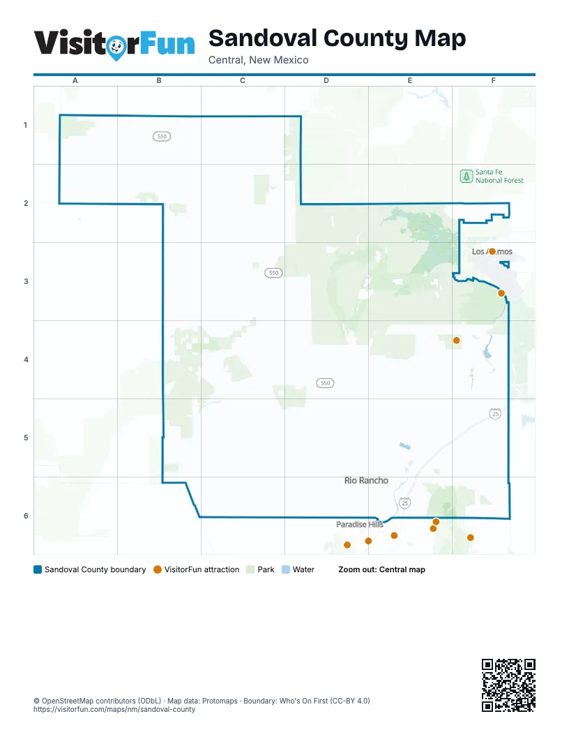
Maps inside Sandoval County
1 map inside, from the street map of Sandoval County down.
Street index of Sandoval County
Each street on the sheet and the grid squares it crosses.
- Pat D'Arco HighwayE5, E6
- Unser Boulevard NortheastD5, E5, D6
- Idalia Road NortheastD6, E6
- Paseo del VolcanE5, D6, E6
- San Diego Overlook RoadE3
- Nra Gateway RoadD3, D4
- Dark Canyon RoadE3
- Unser Boulevard SoutheastD6
- High Resort Boulevard SoutheastE6
- Unser BoulevardD6
- Main StreetC2, E5
- Rio Rancho Boulevard NortheastE5
- Quantum Road NortheastE6
- Alameda Boulevard NorthwestE6
- High Resort BoulevardE6
- Lorretta Drive NorthwestE6
- Navajo Route 474A1, B1, B2, B3, C3
- Northern Boulevard NortheastD6, E6
- El Camino RealE5, E6
- Southern Boulevard SoutheastD6, E6
- Corrales RoadE6
- Enchanted Hills Boulevard NortheastE5, E6
- Pan American Central HighwayE5
- Camino del PuebloE6
- Old Highway 95C1
- Cabezon Boulevard SoutheastD6, E6
- Golf Course Road SoutheastE6
- Country Club Drive SoutheastE6
- Northwest Loop Road NortheastE5
- North Camino del PuebloE5, E6
- East Avenida BernalilloE6
- Ind Sr 475B2
- Ojo Encino RoadB2
- Corrales Road NorthwestE6
- Navajo Route 46A1, B1, A2
- FR 10E3, E4
- San Luis RoadB4, C4
- County Road 11C2, C3
- Torreon RoadC3, C4
- Pipeline RoadA2, B3
- Rainbow Boulevard NortheastD5, D6
- Tetilla Peak RoadF4
- Indian Service Rt 84E5, F5
- La Madera RoadF6
- Old State Highway 279C3, C4
- County Road 57AF5
- Torreon Mission RoadB3, C3
- Southern Boulevard SouthwestD6
- Northern Boulevard NorthwestD6
- Sandia BoulevardD6
- County Road 85C3
- Loma Colorado Boulevard NortheastE6
- Westside Boulevard SoutheastD6, E6
- King Boulevard NortheastD6
- Loma Larga RoadE6
- Cochiti HighwayF4
- Broadmoor Boulevard NortheastE6
- Vallecitos RoadC2, D2, E3
- Mike Judge Street NorthwestD6
- Mario J. Lucero Avenue NorthwestD6
- Los Pinos County RoadC2
- Lincoln Avenue NortheastE5, E6
- Jemez Dam RoadE5
- Camino Encantadas NortheastE5, E6
- Chayote Road NortheastE5, E6
- Atkins RoadA1
- Antonia Apodaca Street NorthwestD6
- Georgia O'Keeffe Street NorthwestD6
- Hagen RoadE5, F5
- Mariposa Parkway NortheastD5, E5
- Isabel R. Lucero Avenue NorthwestD6
- Cherry Road NortheastD6
- Rincon Marquez RoadB3
- Georgia O'Keeffe Street SouthwestD6
- Antonia Apodaca Street SouthwestD6
- Indian Service Rt 601F2
- Iris Road NortheastE6
- future Navajo 461A1
- Mike Judge Street SouthwestD6
- Pueblo Route 85F4
- 17th Avenue NortheastD6, E6
- Pine Road NortheastD6
- Western Hills Drive SoutheastD6
- Abrazo Road NortheastD6
- Tulip Road SoutheastD6
- Westphalia Boulevard NortheastE5, E6
- Kim Road NortheastE6
- Grande Boulevard SoutheastE6
- Rockaway Boulevard NortheastE6
- South Hill RoadE6
- Meadows Boulevard NortheastD6
- Rainbow Boulevard SoutheastD6
- Broadmoor Boulevard SoutheastE6
- Blue Grama Drive NortheastD5
- 10th Street NortheastD6
- Old Lagunitas RoadC2
- Frontage RoadE5, E6
- Wellspring Avenue SoutheastD6
- Lisbon Avenue SoutheastD6
- Sara Road SoutheastE6
- Petroglyph TrailE5, E6
- Cubita RoadC2
- Pecos Loop SoutheastD6
- Tarpon Avenue SoutheastD6
- West Meadowlark LaneE6
- Riverside Drive NortheastE6
- Zia BoulevardD5
- Baltic Avenue SoutheastD6
- 5th Street SoutheastD6
- Terraza Boulevard NortheastE6
- Chessman Drive NortheastD6, E6
- Willow Creek Road NortheastE6
- Southern All Around RoadC2
- Nicklaus Drive SoutheastD6, E6
- Camino Don TomasE6
- 19th Avenue SoutheastD6, E6
- Meadowlark Lane SoutheastE6
- Amy Road NortheastE6
- Cleveland Heights Road NortheastE6
- Rio Vista Drive NortheastE6
- Santa Fe Hills Boulevard NortheastE5
- Sandia Vista Road NortheastE6
- Rio Rancho BoulevardE5
- Montezuma Boulevard NortheastD6, E6
- Honduras Road NortheastE6
- Sandia LoopE6
- Villa Verde Drive SoutheastE6
- Monarch Way NortheastD5, E5
- Sabana Grande Avenue SoutheastE6
- Anasazi Trails RoadE6
- Grande Vista Road NortheastE6
- Leon Grande Avenue SoutheastE6
- Redondo Sierra Vista DriveD5
- Sundt Road NortheastE6
- Arena Drive NortheastD6
- Montreal Loop NortheastE5
- Camino Venada NortheastE5, E6
- Indsr 471B2
- Anasasi TrailE6
- Ridgecrest Drive SoutheastE6
- Safelite Boulevard NortheastE5
- Los Diamantes Drive SoutheastD6
- Champion Road NortheastD6, E6
- Old State Highway 474E5
- Miera RoadC2
- Western Hills Drive NortheastD6
- Sierra Blanca Road NortheastE6
- Old Unser BoulevardD6
- Rincon Marques RoadB3
- Wexford Road SoutheastD6
- Trail Side Boulevard SoutheastD6
- Center Boulevard NortheastD6
- Trailside Road SoutheastD6
- Bell LaneE6
- Pueblo Pintado RoadA2
- Meadowlark Court SoutheastE6
- Civic Center Circle NortheastD6
- HP Way NortheastD6
- Safelite Road NortheastE5
- County Road 1B6
- College Boulevard NortheastD6
- 100 Hagen Road EastE5
- Trail Road EastE6
- Chessman Drive SoutheastE6
- Goldentail Drive NortheastE5
- East Cordova AvenueC2
- Sandia Crest Scenic BywayF6
- West Calle Don FranciscoE6
- Camino Todos Los SantosE6
- Spartan AlleyE6
- Indian Service Route 84E5
- Heaven Sent Gaming fordD6
- Anasazi Trail LoopE6
- Apricot Way NortheastD6
- 30th Avenue NortheastD6
- Edith Boulevard NortheastE6
- Dolores DriveC2
- Lake Fork Canyon RoadE2, D3, E3
- Indian Service Rt 22B1, C1, C2
- Borrego Canyon RoadD4, E4, F4, D5, F5
- Trail Creek RoadD2
- Cabezon RoadD4, C5, D5, E6
- Indian Service Rt 76E4, E5
- Torreon Wash South RoadB4, C4
- 31 Mile RoadE2, E3
- Encino Road NorthwestD5, D6
- VC02E2, E3
- Indian Service Rt 85F4, E5, F5
- Indian Service Rt 38C1
- Elk Springs RoadC3, D3
- Bales/San Miguel RoadD2, D3
- Indian Service Rt 82D4
- Indian Service Rt 48C5, C6
- Dome RoadE3, F3
- Penistaja West RoadB2, C2
- County Road 25B4
- Indian Service Rt 602F2
- Ignacio Chavez RoadB4
- Progress Boulevard NortheastD5, E5, E6
- Indian Service Rt 89E4, F4
- Ridge Cutoff RoadC4
- Indian Service Rt 20B1, C1
- Indian Service Rt 801D4, E4
- Guadalupe RoadB4, C4, E6
- Indian Service Rt 23B1, B2
- Deer Creek RoadD3
- Navajo Route 476B2
- Blue Bird-San Diego RoadD2
- Indian Service Rt 95C3, D3
- Indian Service Route 24B1
- Cerro Pelado RoadE3
- Piedra Lumbre RoadC3
- Puertocito RoadF6
- King Boulevard NorthwestD6
- Rio De Las Vacas RoadD2, D3
- Paso del Norte RoadE3
- Indian Service Rt 788E4
- Torcido Road NorthwestD5, D6
- Indian Service Rt 88F4, F5
- Indian Service Rt 96C3, D3
- Forest Road 103D2
- Progress Boulevard NorthwestD5
- Hot Rock RoadD3, E3
- 24th Avenue NorthwestD6
- Indian Service Rt 86E5
- Frijoles Ridge RoadE3, F3
- 19th Avenue SouthwestD6
- Dome Lookout RoadF3
- FR 488D3
- 5th Avenue SouthwestD6
- 6th Avenue NorthwestD6
- Indian Service Rt 844F5
- Indian Service Rt 79D4
- County Road 472B2
- BLM 1114C4
- Serenade Street NorthwestD5, D6
- NM 165F6
- Bland Canyon RoadE3
- Indian Service Rt 81D4
- Via EntradaF6
- Indian Service Route 93C3, D3
- Middle Fork Ojitos RoadD2
- Camino SaladoC1, D1
- Day School RoadD4, E5
- 9th Avenue NorthwestD6
- Chamisa Canyon RoadC4, C5
- San Pablo RoadC2, D2
- Phoenix Road NorthwestD5, D6
- San Jose RoadC1, D1
- Camino de la Rosa CastillaE5, F5, F6
- Camino de Las HuertasE5, E6, F6
- VC01E3
- FR 269E4
- Thompson Ridge RoadE2, E3
- Lower Mission RoadB3
- FR 289 Dome RoadE3, F3
- County Road 496C1, C2
- North Hill RoadE5, E6
- Vista Road NorthwestD5, D6
- Hidalgo Road NorthwestD6
- Indian Service Rt 606F2
- Los Pinos RoadD1, D2, E6
- Harmony Drive NorthwestD5, D6
- Frost Road NorthwestD5, D6
- Indian Service Rt 92F4
- 8th Avenue NorthwestD6
- 4th Avenue SouthwestD6
- 7th Avenue NorthwestD6
- 23rd Avenue NorthwestD6
- Old Peggy Mesa RoadD3
- Encino Road SouthwestD6
- Sawmill RoadC1, D4, E6
- 27th Avenue NorthwestD6
- Millicent Rogers Street NorthwestD6
- 14th Avenue NorthwestD6
- Mai Shanley Street NorthwestD6
- Sheba Drive NorthwestD5, D6
- Espejo Road NorthwestD6
- La Ventana Cit RoadC3
- Ind Sr 474B1, A2, B2
- 26th Avenue NorthwestD6
- 23rd Avenue SouthwestD6
- Inca Road NortheastD6, E6
- 5th Avenue NorthwestD6
- 14th Avenue SouthwestD6
- 10th Street NorthwestD5, D6
- Forest Road 138E4
- Indian Service Rt 97C3
- 12th Avenue SouthwestD6
- 22nd Avenue NorthwestD6
- 4th Avenue NorthwestD6
- Mai Shanley Street SouthwestD6
- 2nd Avenue SouthwestD6
- Forest Road 78C2, D2
- Indian Service Rt 6B1
- Monterrey Road NortheastE6
- Fire Service Road 531D2
- 13th Avenue NorthwestD6
- Dam Crest RoadF4
- 1st Avenue SouthwestD6
Things to do on the Sandoval County map
Places on the map
- Algodones
- Baca Pit
- Bandelier National Monument
- Bandelier Wilderness
- Bernalillo
- Cabezon Wilderness Study Area
- Cayenne Loop
- Cerro Pelado Burn Scar
- Cerro Seco Trail
- Chamisa Wilderness Study Area
- Cochiti
- Cochiti Dam
- Cochiti Golf Course
- Cochiti Lake
- Cochiti Pueblo
- Corrales
- Corrales Bosque
- Corrales Growing Facility
- Cuba
- Cuba Landing Strip
- Del Norte Gun Club
- Dome Wilderness
- El Cajete Meadow
- Elk Springs Area of Critical Environmental Concern
- Empedrado Wilderness Study Area
- Encantado Walk
- Fenton Lake State Park
- Golden Open Space
- Jemez Canyon Reservoir
- Jemez National Recreation Area
- Jemez Pueblo
- Jemez Springs
- Kasha-Katuwe Tent Rocks National Monument
- La Jara
- La Leña Wilderness Study Area
- Ojito Wilderness
- Peña Blanca
- Placitas
- Rio Grande Bosque
- Valles Caldera National Preserve
Next to Sandoval County
- Los Alamos
- Paradise Hills
© OpenStreetMap contributors, Open Database License, openstreetmap.org/copyright · Map data: Protomaps · Boundary: Who's On First (CC-BY 4.0); Quattroshapes (CC BY 2.0)