

New Mexico map
Socorro County map
About 15,967 people live here (Census Bureau, 2024 estimate). The sheet's index lists 300 streets; Wsmr P Route 7, Wsmr P Route 5 and County Road cross the most grid squares. Things to do inside the boundary: Very Large Array and Bosque del Apache National Wildlife Refuge.
Open the map (PDF, US Letter)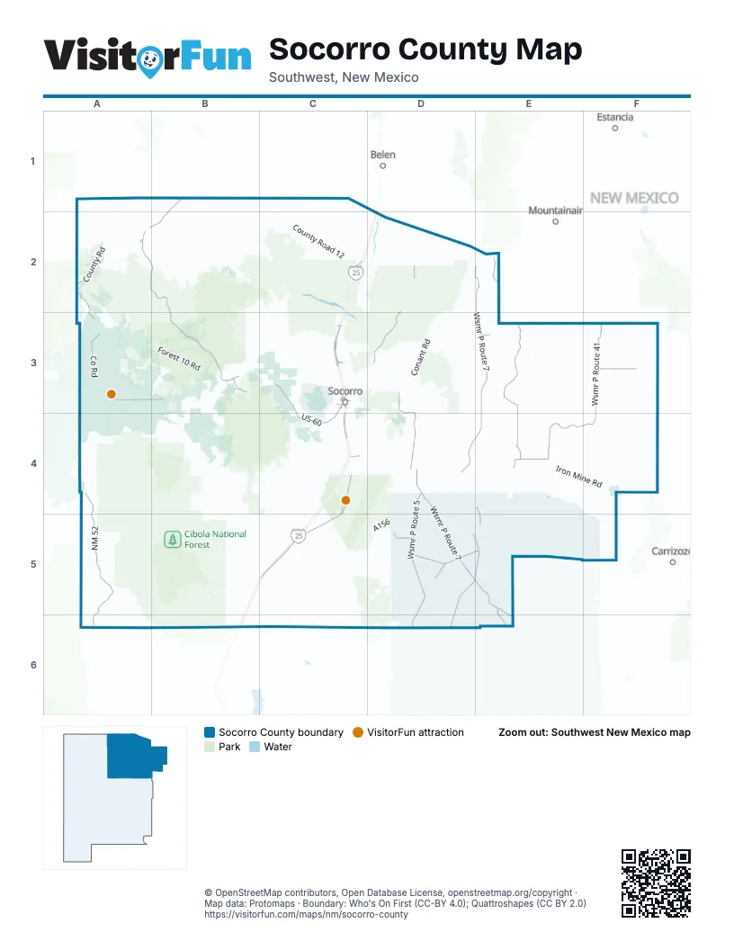
Street index of Socorro County
Each street on the sheet and the grid squares it crosses.
- I-25C3, C5
- I-25 BusinessC3
- US-60C3, C4
- California StreetC3
- Grant StreetC3, C4
- 2nd StreetB3, C3, C4
- 1st StreetB3
- Spring StreetC3
- Wsmr P Route 7E2, E3, D4, E4, D5, E5, E6
- Wsmr P Route 41F3, E4, F4
- NM 52A4, A5, A6
- Old US Highway 85C4, C5
- Frontage RoadC3, C4
- NM 1C3, C4
- Chambon RoadC3
- Calle de LemitarC3
- Alamillo RoadC3
- Highway 304D2
- Wsmr P Route 5D2, D3, D4, D5, D6
- Wsmr P Route 9E2, E3, E4
- County RoadB1, A2, B2, A3
- Indian Service Route 54A2, B2, B3
- Wsmr P Route 13E4, D5, E5, D6
- State Highway 169B3
- Old Highway 60C2, A3, B3
- Wsmr P Route 20D5, E5
- County Road 208F3
- Wsmr P Route 22D5
- Wsmr South Route 347D5
- Kelly RoadB3
- Wsmr P Route 12E5, E6
- Wildlife DriveC4, C5
- Polvadera RoadC3
- El Camino Real StreetC3
- Otero Avenue EastC3
- Leroy PlaceC3
- Neel StreetC3
- Michigan AvenueC3
- Bullock BoulevardC3
- School of Mines RoadC3
- College AvenueC3
- FowlerC3
- El Camino RealC3
- Abeyta AvenueC3
- Burma RoadB6
- Manzaneres AvenueC3
- Fisher AvenueC3
- Plaza StreetC3
- BernardC3
- Forest Road 139A6
- Luna Park RoadB6
- Old State Highway 52B3, A4, B4, A5
- Forest Road 123B1, B2, B3
- Wsmr South Route 3617D3, E3, D4
- Conant RoadD3
- County Road 12B2, C2
- Forest 330 RoadB4
- Chupadera Mesa RoadF3, F4
- Forest 354 RoadB2, B3
- Wsmr South Route 3703E3, F3
- Wsmr South Route 3610E4, E5
- Wsmr South Route 3704E3
- Quebradas RoadD3, D4
- Bosquecito RoadC3, C4
- White Sands Missile Range P Route 9E4, E5
- Wsmr South Route 3803D3
- Forest 476 RoadA4
- Box Canyon RoadC4
- Water Canyon RoadC3, B4, C4
- Forest Road 220A4
- Forest 10 RoadA3, B3
- County Road 1A2, A3
- Forest 52 RoadA4, B4
- Wsmr P Route 26D5
- Iron Mine RoadE4, F4
- Quebradas Back Country BywayC3, D3, C4, D4
- Wsmr South Route 3511E4, F4
- Chaparral LoopC3
- Muleshoe RoadB4
- Wsmr South Route 3611D3, D4
- Willow Springs Ranch RoadC4, C5
- Wsmr P Route 18E3, D4, E4
- Staton RoadC3
- Socorro Gun Club RoadC4
- Short Cut RoadD3, D4
- Forest Road 128AB3
- Soccorro Co Road 41E3, E4
- Bianca Ranch RoadC4
- Wsmr P Route 11E5, F5
- County Road 206F3
- East Low Flow RoadC3
- Wsmr South Route 3706E3
- Wsmr South Route 3509E4
- Forest Road 354FC2, B3, C3
- Red Lake RoadA1, A2
- Levy RoadC3, C4
- Wsmr P Route 24D4, E4
- Martin's RoadA2
- Wsmr South Route 3609D4
- County Road 187F3
- Wsmr South Route 3807D2, E2, D3
- County Road 51B2
- Forest Road 10AB3
- Wsmr South Route 3808D3, E3
- Range Road 9E2
- Wsmr South Route 3613D3
- Wsmr South Route 3810D3, E3
- Wsmr South Route 3607D3, D4
- Wsmr South Route 3505E4
- Forest 478 RoadA5
- County Road 105D2
- Farm Market RoadC4
- Chupadera Mesa Spur RoadF4
- Arroyo de la Canas TrailD3, C4, D4
- Wsmr South Route 332E5
- Escobar StreetD2
- Strozzi RoadC3
- Merch RoadA1
- Wsmr South Route 3508E4
- Forest Road 10BB3
- North LoopC4
- Wsmr South Route 3513E3, E4
- Wsmr South Route 3506E4
- Forest 10C RoadB3
- Johnson Hill RoadC3, D3
- Old Highway 85C2
- Wsmr South Route 3517E3
- Wsmr South Route 3515E3
- A156D5
- Wsmr South Route 3501E4
- Black Hills RoadF4, F5
- County Road 191F3
- Busquiedo RoadC3, D3, C4
- Co RoadA3
- Forest Road 477A4, A5
- Pipeline RoadF3
- Rock Spring RoadB4
- Wsmr South Route 3701E3
- Wsmr South Route 3702E3
- Manzanita DriveD2
- Forest 467 RoadB3
- Fort Craig RoadC5
- Payne RoadF5
- Wsmr South Route 3806D3, E3
- West Low Flow RoadC3, C4
- County Road 138D2
- Forest Road 469B3
- White Sands Missile Range South Route 331E5
- Water Tank RoadB3, C4
- County Road 193F3
- Garcia StreetD2
- Forest 505 RoadC3, C4
- White Sands Missile Range S Route 337E5
- Riverside RoadC3, C4
- County Road 28A2, B2
- Forest Road 10A3, B3
- Wsmr South Route 342D5
- Hop Canyon RoadB3
- Forest RoadB3
- Indian Service Route 7035A2
- Wsmr P Route 73E5
- Indian Service Route 7030B2
- North Fork RoadB3, C3, B4, C4
- Cienega Camp RoadC4
- Indian Service Route 7032B2
- Wsmr South Route 3804D3, E3
- Ditch RoadC3, C4
- Forest Road 24B3
- Wsmr South Route 337E5
- Olquin RoadC3
- South Canyon RoadC3, C4
- Wsmr South Route 341E5
- South LoopC4, C5
- Wsmr South Route 3604D4
- Forest 469 RoadB3
- Road 1230B3
- Forest Road 473A4
- 3 Tank RoadB2
- Wsmr South Route 3519E3
- Wsmr South Route 349D5
- County Road 190F3, F4
- Wsmr South Route 3507E4
- Forest Road 73A5
- County Road 1598C5
- East RoadC3
- County Road 27B2
- Canal RoadD2, C3
- Alamillo Frontage RoadC2, C3
- Canyon RoadC3
- Frontage Road 2039C3
- Guadalajara RoadC4
- Seasonal Tour RoadC4, C5
- Wsmr South Route 3621E4
- Wsmr South Route 3606D4
- Wsmr South Route 3514E4
- Hope FarmsC3, C4
- L-C94E4
- Wsmr South Route 3512E4
- Wsmr 341E5
- Hardy Spring RoadB4
- San Lorenzo RoadD2
- A153D4, D5
- Wsmr South Route 344D4
- Kelly Canyon RoadC3
- Jaramillo LoopD2
- Wsmr 18E3, E4
- Olive LaneC3
- Frontage 2051 RoadC3
- Wsmr South Route 325E6
- Wade RoadF3
- Slaton RoadC3
- Jones RoadD4
- Drain Ditch RoadC3
- 6th StreetB3, C3, C4
- Romon Lopez RoadC2
- Ao 99A3
- Juanita AvenueD2
- Mario AvenueD2
- CR 24A2
- Forest 505E RoadB3
- Main StreetB3, C3
- County Road 26B2
- Torian RoadD2
- Frontage Road 2040C3
- Forest 249 RoadB3
- Veguita Farms LoopD2
- Carlos Martinez RoadD2
- Chaparral DriveC3
- County Road 213F3
- South Alamillo RoadC3
- Camino Luis LopezC4
- Northwest Frontage RoadC3
- East Ditch RoadC4
- Fite Ranch RoadD4
- 5th StreetB3, C3, C4
- Torreon Spring RoadC4
- South Miera RoadC4
- Las Nutrias RoadD2
- Rodeo DriveC3
- North Chaparral DriveC3
- Wsmr South Route 324E5
- County Road 175F3, F4
- Lopezville RoadC3
- Camino UlibarriD2
- 10th StreetB3
- Kuntz RoadD2
- Fr57B4
- Schmittle RoadC3
- Evergreen DriveC3
- San Lorenzo Canyon Road TrailC3
- Bosque RoadC4
- Midway RoadC3
- County Road A206F3
- San Marcial RoadC5
- Military HighwayD2
- Campos AvenueD2
- 3rd StreetB3, C4
- Forest Road 47B4
- Hamburger Hill RoadA2, B2
- San Acacia RoadC3
- Stendel RidgeB3
- Frontage Road 2038C3
- Gallagher RoadB3
- Valley LoopC3
- North Ash StreetB3
- GrefcoC4
- 8th StreetB3
- Community RoadC3
- Gravel Pit RoadC4
- Windy's Farm RoadC4
- San Antonito RoadC4
- Paizalas DriveD2
- Granillo RoadD2
- Coyote Springs RoadC4
- 4th StreetB3, C4
- Fr 57B4
- Fairgrounds RoadC3
- Randolph LoopD2
- Polvadera Heights RoadC3
- Alpha RoadC3
- Jurado AvenueD2
- Wsmr P Route 5 / Luna RoadD2
- Newberry RoadC3
- Spruce StreetB3
- Badger LaneD2
- County Road 153D4
- Park StreetC3
- Duke LaneC3
- Salt Cedar RoadD2
- Zanja RoadC4
- Hidden LaneC3
- Montoya RoadC4
- Cuba RoadC3
- Calle de AllegreD2
- Pine StreetB3
- Copper Canyon RoadC4
- High School RoadC3
- Melecio LaneD2
- Martino RoadD2
- Cassady LaneC3
Things to do on the Socorro County map
Places on the map
- Alamo
- Antelope Flats
- Antelope Wilderness Study Area
- Apache Kid Wilderness
- Arroyo Chanthe
- Arroyo de Alamillo
- Bernardo Wildlife Management Area
- Black Mountain
- Bosque del Apache National Wildlife Refuge
- Brown Arroyo
- Chupadera Wilderness
- Cibola National Forest
- Devils Backbone Wilderness Study Area
- DicaPerl Quarry, Socorro
- EMRTC Testing Site
- Haw Farms
- Hells Mesa
- Indian Well Wilderness
- Jornada del Muerto Malpais
- Jornada del Muerto Volcano
- Jornada del Muerto Wilderness Study Area
- Kelly Canyon Arroyo
- La Joya Wildlife Management Area
- Little San Pascual Wilderness
- Low Flow Conveyance Channel
- Magdalena
- Mesa Cencerro
- Mesa del Contadero
- Mesa Trail #13 Loop
- Milligan Gulch
- New Mexico Tech Golf Course
- Nogal Arroyo
- Plains of San Augustin
- Salinas Pueblo Missions National Monument
- Sevilleta National Wildlife Refuge
- Sierra Ladrones Wilderness Study Area
- Socorro Municipal Airport
- Stallion Wilderness Study Area
- Veranito Wilderness Study Area
- Withington Wilderness
Next to Socorro County
- Belen
- Carrizozo
- Estancia
- Mountainair
© OpenStreetMap contributors, Open Database License, openstreetmap.org/copyright · Map data: Protomaps · Boundary: Who's On First (CC-BY 4.0); Quattroshapes (CC BY 2.0)















