

New Mexico map
Sunland Park map
About 18,185 people live here (Census Bureau, 2024 estimate). The sheet's index lists 253 streets; McNutt Road, US Border Patrol Road and Crawford Road cross the most grid squares. Also on it: Sunland Park Racetrack & Casino, Western Playland and City Of Sunland Sports Complex.
Open the map (PDF, US Letter)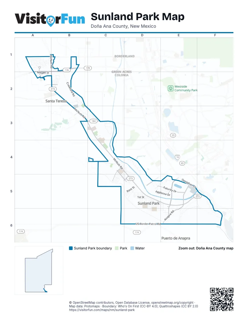
Street index of Sunland Park
Each street on the sheet and the grid squares it crosses.
- Alliveal LaneA1
- Ash Park StreetA1
- Blue Park AvenueA1
- Borderland RoadA1, B1
- Brass Hill AvenueA1
- Bronze Hill AvenueA1
- Cedar Park StreetA1
- Copper Hills StreetA1
- Cumin Peak StreetA1
- Fender Hill StreetA1
- Galluim AvenueA1
- Ginger Park StreetA1
- Hanson CircleA1
- Holly Park AvenueA1
- Iron Hill AvenueA1
- Jade Hill AvenueA1
- Laurel Park StreetA1
- Maple Park AvenueA1
- McNutt RoadA1, B1, B2, B3, C3, C4, D4, D5, E5, F5
- Mercury CircleA1
- Nickel Hill AvenueA1
- Peter V. Domenici International HighwayA1, B1, A2
- Russell BoulevardA1, A2
- Silver Park StreetA1
- Steel Hill AvenueA1
- Tin Hill StreetA1
- Zinc Hill StreetA1
- Artcraft RoadB1
- Crawford RoadB1, B2, B3, C3
- Overcas StreetB1
- Alpha CircleA2
- Applewood StreetA2
- Ashwood StreetA2
- Baywood StreetA2
- Beechwwod StreetA2
- Blackwood StreetA2
- Bocote Wood StreetA2
- Bywood StreetA2
- Cocobolo StreetA2
- Commerciantes BoulevardA2, B2
- Durrill StreetA2
- Elizabeth StreetA2
- Irene StreetA2
- Laurensito StreetA2
- Megan StreetA2
- Aberdeen CourtB2
- Airport RoadB2
- Alamo RoadB2
- Angelica CourtB2
- Arcy StreetB2
- Becca DriveB2
- Berwyn StreetB2
- Bonnie CourtB2
- Britain DriveB2
- Edgemont RoadB2
- Edinburgh DriveB2
- Elbow Bend DriveB2
- Elsa StreetB2
- England DriveB2
- Essex LaneB2
- Ireland DriveB2
- Lauren StreetB2
- Leeds DriveB2
- London DriveB2
- Lourdes DriveB2
- Manchester DriveB2
- Mason Farms RoadB2, B3
- Missy CourtB2
- Naranjo RoadB2
- New Castle CourtB2
- NottinghamB2
- Ranneradale CourtB2
- Speyside DriveB2
- Valley West LaneB2
- Wales DriveB2
- Winoffmore CourtB2
- Alden DriveB3, C3
- Calle EsondidaB3
- Chalk Mountain CourtB3
- Colorado LaneB3
- Country Club RoadB3, C3
- Cuaron CourtB3, C3
- De Sote PlaceB3
- Desert Lilly CourtB3
- Desert Sage CourtB3
- La Entrada CircleB3
- Paseo La EntradaB3
- Sea Pines DriveB3
- Tierra Vista DriveB3, C3
- Venture CourtB3
- Via GlorietaB3
- Willow DriveB3, C3
- Bravo DriveC3
- Country Cove CourtC3
- Golf East DriveC3
- Golf West DriveC3
- Grove DriveC3
- Laura CourtC3
- Livingston DriveC3
- Ray Ward PlaceC3
- Santa Teresita DriveC3
- Santo Ysidro RoadC3
- Aspen DriveC4, D4
- Birch DriveC4, D4
- Brazos DriveC4, C5
- Cedar CourtC4
- Colorado DriveC4, C5
- Gardenia CourtC4
- Las Flores CourtC4
- Memorial Pines LaneC4
- Mount Cristo Rey BoulevardC4, C5, D5
- Neches CourtC4
- Nueces StreetC4, D5
- Rio Grande DriveC4, C5
- Rio Rojo DriveC4, C5
- Riverside DriveC4, D4, D5
- Sabine DriveC4, D4, C5
- Sueño CourtC4
- Tierra Madre DriveC4
- Trinidad DriveC4, C5
- Villa del Rio LoopC4
- Appaloosa CourtD4
- Appaloosa DriveD4
- Elm CourtD4
- Equestrian LaneD4
- Fir CourtD4
- Forest Willow CircleD4
- Gary LaneD4
- Girl Scout LaneD4, D5
- HorseshoeD4
- Locust CourtD4
- Magnolia CourtD4, D5
- Maple CourtD4
- Poplar CourtD4, D5
- Poplar DriveD4, D5
- Quarter Horse LaneD4
- Rancho del Rio DriveD4
- Thoroughbread CourtD4
- Willow West DriveD4
- Winner CircleD4
- Carrizo DriveC5, D5
- Chama DriveC5, D5
- Gila DriveC5, D5
- Mora LaneC5, D5
- Pecos DriveC5, D5
- Rio Alamos DriveC5
- Rio Chama DriveC5
- 1st StreetD5
- 2nd StreetD5
- 3rd StreetD5
- 4th StreetD5
- 5th StreetD5
- Alamo DriveD5
- Alto Vista DriveD5
- Anita CourtD5
- Anita StreetD5
- Apploosa DriveD5, E5
- Bella Vista CourtD5
- Boy Scout CourtD5
- Boy Scout LaneD5, E5
- Buena Vista DriveD5
- Camino Real DriveD5
- Cuchillo PlaceD5
- Del Prado DriveD5
- Desert CourtD5, D6
- Edgewood BoulevardD5
- El Centauro DriveD5
- Encino StreetD5, D6
- Frida StreetD5
- Frontera RoadD5
- Futurity DriveD5, E5
- Granada AvenueD5
- Hacienda Rey DriveD5
- Hacienda Roja CourtD5
- Hacienda Roja DriveD5, E5
- Hacienda Sol DriveD5, E5
- Hondo DriveD5
- Las Arenas DriveD5, D6
- Las Lomitas DriveD5
- Liliana DriveD5
- Linda Vista DriveD5
- Loma Vista DriveD5
- Lonnie StreetD5
- Luna DriveD5
- Lura StreetD5
- Maguey CourtD5
- Manzana StreetD5
- Meadow Vista BoulevardD5
- Mesa Verde DriveD5
- Mimbre DriveD5, E5, D6
- Monte Vista CourtD5
- Monte Vista DriveD5
- Mount Criso Rey BoulevardD5
- Ocotillo DriveD5, E5
- Palo Verde DriveD5
- Palomas PlaceD5
- Peñasco LaneD5
- Pinon DriveD5, D6
- Redwood CourtD5
- Rio Vista DriveD5
- Rita StreetD5
- Ross StreetD5
- Saint Jose CourtD5
- San Gabriel DriveD5
- Santa Domingo DriveD5
- Santa Isabela DriveD5
- Sierra Vista DriveD5
- Spruce DriveD5
- Sun CourtD5
- Valle Vista DriveD5
- Walnut CourtD5
- Yucca DriveD5
- Zuni DriveD5
- Zuni LaneD5
- Anapra RoadE5, E6
- Antone StreetE5, E6
- Calle CarroselE5, F5
- Calle DiazE5, F5
- Cristo Rey RoadE5, F5, F6
- Derby RoadE5
- Doniphan DriveE5
- Gibson Veck RoadE5
- Gibson Veck SiteE5
- Palma DriveE5, E6
- Posey RoadE5, E6
- Quinella RoadE5
- Racetrack DriveE5
- Riverview CourtE5, E6
- Robles DriveE5, E6
- Sunland Park DriveE5
- US Border Patrol RoadE5, F5, D6, E6, F6
- Victory DriveE5
- Brickland RoadF5, F6
- Calle HidalgoF5
- Calle MaderoF5
- Calle MorrocoF5
- Calle ObregonF5
- River Levee RoadF5
- El Cerro DriveD6, E6
- Encino DriveD6, E6
- Father Luis CatanoD6
- Linda CourtD6
- Linda LaneD6
- Ardovinos DriveE6
- Carlos Aguirre CourtE6
- Fielder CourtE6
- Findley CourtE6
- Fuentes AvenueE6
- High RoadE6
- Hope CourtE6
- Hurd LaneE6
- Low RoadE6
- Morrison LaneE6
Places on the map
- Ardovino's Desert Crossing
- Billy Crews
- Bumper Cars
- Cardiel Cannabis Co.
- Carousel
- City Of Sunland Sports Complex
- Cookies Weed Dispensary Sunland Park
- Cristo Rey
- Desert View Elementary School
- Drop Zone
- El Paso Del Rio Del Norte
- Family Dollar
- Flying Scooters
- Games
- Hanson Circle
- Himalaya
- International Boundary Monument Number 1
- Mailroom
- Memorial Pines
- Mender Park
- Museo Casa de Adobe
- Paratroopers
- Peak Behavioral Health
- Peak Behavioral Health Services
- Pharaoh's Fury
- Riverside Elementary School
- Saint John Paul II Catholic Church
- San Antonio
- San Jose
- San Martin de Porres Catholic Church
- Santa Teresa Middle School
- Scrambler
- Sierra de Cristo Rey
- Sunland Park Elementary School
- Sunland Park Grocery
- Sunland Park Post Office
- Sunland Park Racetrack & Casino
- The Hotel at Sunland Park Racetrack & Casino/West El Paso
- Western Playland
- William Clark Snow Park
Next to Sunland Park
- Borderland
- Green Acres Colonia
- Prado Verde Addition Number 1 Colonia
- Puerto de Anapra
- Santa Teresa
© OpenStreetMap contributors, Open Database License, openstreetmap.org/copyright · Map data: Protomaps · Boundary: Who's On First (CC-BY 4.0); Quattroshapes (CC BY 2.0)















