

New Mexico map
Doña Ana County map
The sheet's index lists 300 streets; Pearl Harbor Memorial Highway, Wsmr P Rt 7 and Bataan Memorial Highway cross the most grid squares. Things to do inside the boundary: Farmers & Crafts Market of Las Cruces, Mesilla Valley Mall and War Eagles Air Museum. Also on it: Jornada Experimental Range, Organ Mountains-Desert Peaks National Monument and Potrillo Mountains Wilderness.
Open the map (PDF, US Letter)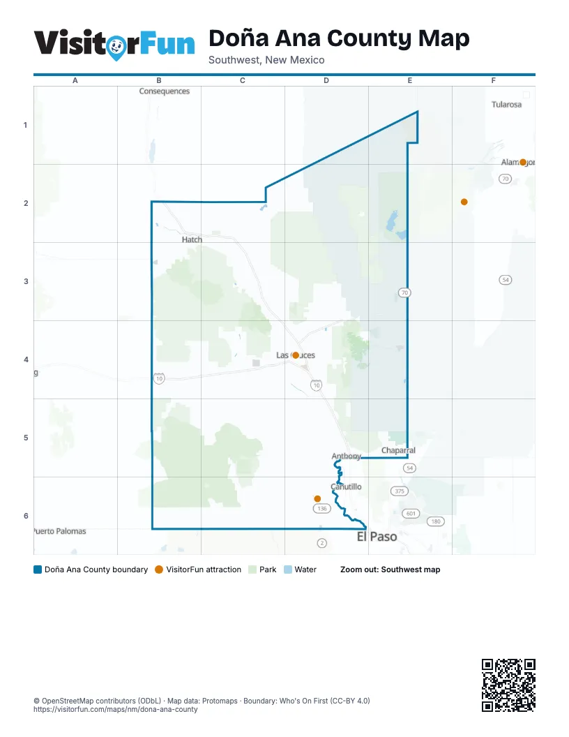
Maps inside Doña Ana County
2 maps inside, from the street map of Doña Ana County down.
Street index of Doña Ana County
Each street on the sheet and the grid squares it crosses.
- Pearl Harbor Memorial HighwayB4, C4, D4, D5
- Bataan Memorial HighwayD3, E3, D4
- Camino Real de Tierra AdentroD5
- North Valley DriveC3, C4, D4
- Peter V. Domenici International HighwayD6
- East Hall StreetB2, B3, C3
- US Highway 70 WestE3
- West Picacho AvenueC4, D4
- South Main StreetD4
- East O'Hara RoadD5, E5
- New Mexico State Road 26B2, B3
- O'Hara RoadD5, E5
- Camino Real StreetD5
- Highway 478D5
- North Main StreetD4, D5
- South Valley DriveD4
- East University AvenueD4
- NM 213E5
- Pan American HighwayB2
- Main StreetB2, D4, D5
- West University AvenueD4
- West Hall StreetB2
- Peter V. Domenici International BoulevardD6
- Artcraft RoadD6
- West Canal RoadB2
- Franklin StreetB2
- Hall StreetB2
- Loya LaneC4
- Aloe Vera LaneC4
- Martin Luther King Jr BoulevardE5
- A003 County RoadB6, C6, D6
- Sonoma Ranch BoulevardD3, D4
- McNutt RoadD6
- Bataan Memorial WestD3, D4
- Bataan Memorial EastD4
- Dripping Springs RoadD4
- North Roadrunner ParkwayD4
- War RoadE5
- East Lohman AvenueD4
- New Mexico State Road 549B4
- Engler RoadD4
- Del Rey BoulevardD4
- Elks DriveD4
- Mossman Arroyo RoadD4, D5
- North Motel BoulevardD4
- South Telshor BoulevardD4
- Avenida de MesillaD4
- Owen RoadE3, E4
- West Amador AvenueD4
- Northrise DriveD4
- Anthony DriveD5
- West O'Hara RoadD5
- East Lisa DriveE5
- Fort Selden RoadC3
- Gecko AvenueB4
- North Telshor BoulevardD4
- Sunland Park DriveD6
- Missouri AvenueD4
- McCombs DriveE5
- Mesquite DriveD5
- Washington StreetB2, D5
- Country Club RoadD6
- West Lisa DriveE5
- South Solano DriveD4
- Vado RoadD5
- Headquarters AvenueE4
- State Highway 228D5
- El Paseo RoadD4
- North Solano DriveD4
- Calle de El PasoD4
- North Alameda BoulevardD4
- Spruce AvenueD4
- Rincon RoadC2
- West Thorpe RoadC4, D4
- Picacho Hills DriveC4
- East Amador AvenueD4
- West Boutz RoadD4
- Highway 189D5
- East Boutz RoadD4
- West Side RoadD4
- East Thorpe RoadD4
- Canutillo-la Union RoadD6
- East Picacho AvenueD4
- South Anthony DriveD5
- South Alameda BoulevardD4
- Boutz RoadD4
- Doniphan DriveD6
- West Lohman AvenueD4
- Canutillo la Union AvenueD6
- West Washington StreetD5
- White Sands Missile Range P Route 7D1, E2, E3
- White Sands Missile Range P Route 21E3, E4
- County Road B004B4, B5, C5
- West Afton RoadC5, D5
- North Jornada RoadD3, D4
- Stern DriveD4, D5
- County Road E070C2, C3
- Las Alturas DriveD4, D5
- Wsmr P Rt 21E3
- Snow RoadC4, D4
- Dona Ana RoadC3, C4, D4
- Airport RoadD6
- North Frontage RoadC4, D5
- Holman RoadD3, D4
- Aguirre Springs RoadD3, D4
- Robert Larson BoulevardC4
- Hueco Camp RoadE5
- Westside RoadD5, D6
- Shalem Colony TrailC4
- Wsmr P Rt 7D1, E1, E2, E3
- White Sands Missile Range P Route 3E4
- NASA RoadD3, D4
- White Sands Missile Range P Route 2E4
- Strauss RoadD6
- Baylor Canyon RoadD4
- County Road E072C2
- White Sands Missile Range S Route 202E3, E4
- Alvarez RoadD5, D6
- Soledad Canyon RoadD4
- El Camino RealD4
- Doña Ana RoadC3
- Arroyo RoadD4
- Peachtree Hills RoadD4
- Three Saints RoadD5
- Rinconada BoulevardD4
- State Line DriveE5
- County Line DriveE5
- El Centro BoulevardD3
- High Valley RoadD5
- Brahman RoadD3, D4
- Roadrunner LaneC4, D4
- Settlers PassD4
- South Espina StreetD4
- East Idaho AvenueD4
- North Triviz DriveD4
- Loma Parda RoadB2
- Hermosa DriveE5
- Crawford BoulevardC4
- West Berino RoadD5
- Triviz DriveD4
- Sonora Springs BoulevardD4
- Golf Club RoadD4
- West Union AvenueD4
- Casad RoadD6
- West Hadley AvenueD4
- Calle AbueloD4
- Berino RoadD5
- West Frontage RoadD5
- South Fairacres RoadC4
- Arrowhead DriveD4
- Sedona Hills ParkwayD4
- South Triviz DriveD4
- Mesa DriveD4
- Red Hawk Golf RoadD4
- Calle del NorteC4, D4
- Geothermal DriveD4
- Cortez DriveD4
- Corona RoadD3
- Lenox AvenueD4
- Carriage Hills RoadB2
- Mesa Grande DriveD4
- Dairy Farm RoadD5
- Morningstar DriveD4
- Martin Luther King Jr AvenueE4
- East Griggs AvenueD4
- Calle Jitas BoulevardD4
- West Taylor RoadC4, D4
- North 4th StreetD5
- Burke RoadC4
- Weisner RoadD3, D4
- Wells StreetD4
- North Fairacres RoadC4
- Sam Steel WayD4
- East Madrid AvenueD4
- B B RomigB2
- North Vinton RoadD5
- Porter DriveD4
- North Mesquite StreetD4
- Acosta RoadD5
- Locust StreetD4
- South Don Roser DriveD4
- Las Alturas StreetD4, D5
- Camino CoyoteD4
- Barcelona Ridge RoadC4
- Stewart StreetD4
- Parkhill DriveD4
- Aberdeen AvenueE4
- Las Colinas DriveD4
- Watson LaneD4
- North Country Club RoadD6
- Birch LaneB2
- Holguin RoadD5
- Tashiro DriveC4, D4
- Spitz StreetD4
- Dyer StreetD4, E4
- Church StreetD5
- Futurity DriveD6
- Aldrich RoadD4
- Baylor Canyon DriveD4
- Vinton RoadD5
- Anapra RoadD6
- County Road E071C2
- Carver RoadD4
- Mercantil AvenueD5
- Placitas AvenueB2, B3
- Ripley StreetE4
- Bruins LaneC4, D4
- Borderland RoadD6
- Hope RoadC3
- Cholla RoadD4
- Links RoadD5
- Picatinny AvenueE4
- Northwind RoadC4
- McGuffey StreetD4
- Westwind RoadC4
- East Las Cruces AvenueD4
- Mesilla Dam RoadD4
- Gardner RoadD6
- Dunn DriveD4
- Village DriveD4
- Central RoadD4
- Foothills DriveD4
- South Mesquite StreetD4
- Hoagland RoadD4
- County Road E062B2
- Racetrack DriveD6
- Lujan Hill RoadC3, C4
- South Walnut StreetD4
- Via NorteC4
- Las Uvas Diary RoadB3
- Lopez RoadC4, D4
- Rancho Santa Teresa BoulevardD6
- San Jacinto RoadD5
- Mars AvenueD4
- Southwind RoadC4
- Bi-National AvenueD6
- Landers RoadD5
- South Compress RoadD4
- Sonoma Springs RoadD4
- East Taylor RoadD4
- Sirocco AvenueD4
- Nike AvenueD4, E4
- North Walnut StreetD4
- Pegasus DriveD4
- East Union AvenueD4
- County Road D036D4
- Terrace DriveD4
- North 17th StreetD4
- Rio Grande DriveD6
- Hughes StreetE4
- Gato RoadD4, D6
- Herrera RoadB2
- Mission RoadD4
- North Campo StreetD4
- County Road E027B2
- Leasburg Dam RoadC3
- Luna DriveE5, D6
- Mount Cristo Rey BoulevardD6
- Three Crosses AvenueD4
- Duffer LaneD5
- Garfield RoadB2
- Edgemont RoadD6
- Central AvenueD4
- South Campo StreetD4
- Sundown RoadD4
- North Mesilla StreetD4
- Loma PardaB2
- East Dõna Ana School RoadD4
- Posey RoadD6
- Tortugas DriveD4
- Bb Romig DriveB2
- East Aerobee AvenueE4
- Myles RoadC4, D4
- West Madrid RoadD4
- Commerciantes BoulevardD6
- West Las Cruces AvenueD4
- Dõna Ana School RoadC4, D4
- Water StreetD4, D5
- Jasmine DriveD4
- North Church StreetD4
- Wyatt DriveD4
- Monticello AvenueB2
- Frontera RoadD6
- Russell BoulevardD6
- Metro Park StreetD4
- Tigua DriveD4
- Elm RoadB2
- West Griggs AvenueD4
- South 17th StreetD4
- Gila DriveD6
- Westside DriveD6
- Walton BoulevardD4
- Sunlit Valley DriveD6
- Sea Pines DriveD6
- Hanson CircleD6
- North Compress RoadD4
- County Road B108B2
- South Church StreetD4
- South Water StreetD4
- Camagage Hills RoadB2
Things to do on the Doña Ana County map
Places on the map
- Aden Lava Flow Wilderness
- Anthony
- Bill Inman Pit #1
- Broad Canyon Wilderness
- Chaparral
- Cinder Cone Wilderness
- Condron Army Airfield
- Doña Ana
- East Potrillo Mountains Wilderness
- Flat Lake
- Foothills Plaza
- Former Las Cruces Country Club
- Hatch
- Jornada Experimental Range
- Kilbourne Hole ACEC
- La Llorona Park
- Lake Lucero
- Las Cruces
- Leasburg Dam State Park
- Mesilla
- Mesquite
- Mount Riley Wilderness
- Old Coe Lake
- Organ Mountains Wilderness
- Organ Mountains-Desert Peaks National Monument
- Picacho Hills Country Club
- Potrillo Mountains Wilderness
- Prehistoric Trackways National Monument
- Radium Springs
- Red Hawk Golf Club
- Rincon
- Robledo Mountains Area of Critical Environmental Concern
- Robledo Mountains Wilderness
- Salem
- San Andres National Wildlife Refuge
- Santa Teresa
- Santa Teresa Intermodal Ramp
- Sierra de las Uvas Wilderness
- White Sands
- Zone of Cooperative Use
Next to Doña Ana County
- Alamogordo map
- Canutillo
- El Paso
- Puerto Palomas
- Truth or Consequences
- Tularosa
© OpenStreetMap contributors, Open Database License, openstreetmap.org/copyright · Map data: Protomaps · Boundary: Who's On First (CC-BY 4.0); Quattroshapes (CC BY 2.0)















