

New York map
Arrochar map
A printable two-page map of Arrochar (Staten Island, New York), drawn by VisitorFun from OpenStreetMap. Page two is the street index: every street on the sheet with its grid square, the same list as below.
Open the map (PDF, US Letter)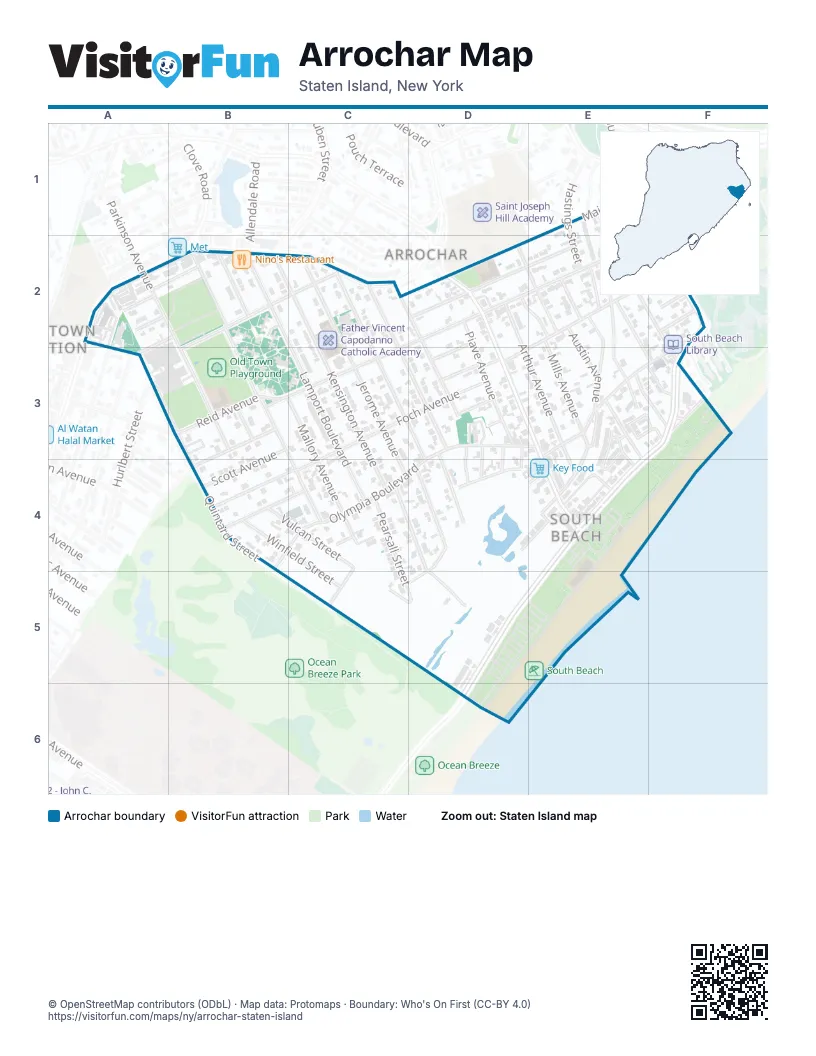
Street index of Arrochar
Each street on the sheet and the grid squares it crosses.
- Florida AvenueE1, E2
- Hastings StreetE1, E2
- Major AvenueE1, C2, D2
- Savo LaneE1
- Hylan BoulevardA2, B2, C2
- Kermit AvenueA2, B2
- McCormick PlaceA2
- Old Town RoadA2
- Parkinson AvenueA2, B2, B3
- Quintard StreetA2, A3, B3, B4
- Clove RoadB2
- Kensington AvenueB2, C2, C4
- Kramer StreetB2, C2, B3
- Lamport BoulevardB2, C3, C4
- Ledyard PlaceB2, A3
- Mallory AvenueB2, B3, C4
- Norway AvenueB2, B3, C4
- Steuben StreetB2
- Bionia AvenueC2, C3, D4
- Hickory AvenueC2, D3
- Jerome AvenueC2, C4
- Linwood AvenueC2, D3
- Arthur AvenueD2, E3, E4
- MacFarland AvenueD2, E2
- McClean AvenueD2, E2, F2, B3, C3
- Mills AvenueD2, E2, E3
- Pershing StreetD2, D3
- Piave AvenueD2, D3
- Sand LaneD2, D3, E3, E4
- Wallace AvenueD2, E2
- Austin AvenueE2, E3
- Cedar AvenueE2, D3
- Conger StreetE2
- Jackson AvenueE2, E3
- Ocean AvenueE2, F2, F3
- Railroad AvenueE2, E3
- Retner StreetE2, E3
- Waterford CourtE2, F2
- Windom AvenueE2, F3
- Father Capodanno BoulevardF2, F3, E4, D5
- Galesville CourtF2
- Guilford StreetF2
- Lily Pond AvenueF2
- Palisade StreetF2
- Robin RoadF2, E3, F3
- Cameron AvenueB3, B4
- Oberlin StreetB3
- Reid AvenueB3
- Scott AvenueB3
- Foch AvenueC3, D3, C4
- Argonne StreetD3
- Balfour StreetD3, D4
- Cambria StreetD3
- Diaz StreetD3
- Humbert StreetD3
- Olympia BoulevardD3, E3, C4, D4
- Orlando StreetD3, D4
- South Beach AvenueD3, D4
- Wentworth AvenueD3, D4
- Wills PlaceD3, D4
- Alex CircleE3, E4
- Doty AvenueE3, E4
- Linda AvenueE3, F3
- Oceanside AvenueE3, E4
- Ragazzi LaneE3
- Sea Gate CourtE3, F3
- Seaside LaneE3, F3
- Drury AvenueF3
- Vulcan StreetB4, C4, C5, D5
- Winfield StreetB4, C5
- Appleby AvenueC4
- Lava StreetC4
- McLaughlin StreetC4, D4, D5
- Nugent AvenueC4
- Patterson AvenueC4
- Pearsall StreetC4, C5, D5
- Tony CourtC4
- Andrews StreetD4
- Crestwater CourtD4, E4
- Lansing StreetD4
- Quincy AvenueD4, E4, D5
- Sunnymeade VillageE4
- Agnes PlaceC5, D5
Places on the map
- Father Vincent Capodanno Catholic Academy
- Holy Rosary Catholic Church
- Hylan Shopping Center
- Key Food
- Lot 1
- Lot 2
- Lot 3
- Lot 4
- Nino's Restaurant
- Oceanside Park Estates
- Old Town Playground
- P.S. 39 - The Francis J. Murphy Jr. School
- P.S. 46 - Albert V. Maniscalco Elementary School
- Saint Marys Cemetery
- Sea Gate Court
- Shop N Save Superette
- South Beach
- South Beach Houses
- South Beach Library
- South Beach Wetlands
- The Shops at South Beach
- Vanderbilt at South Beach
Next to Arrochar
- Old Town Station
© OpenStreetMap contributors (ODbL) · Map data: Protomaps · Boundary: Who's On First (CC-BY 4.0)