

New York map
New York State map
Things to do inside the boundary: & Juliet, 9/11 Memorial & Museum and Adventureland. Also on it: Adirondack Park, Aldrich Pond Wild Forest and Allegany State Park. Just past the edge: Allentown, Concord and Erie.
Open the map (PDF, US Letter)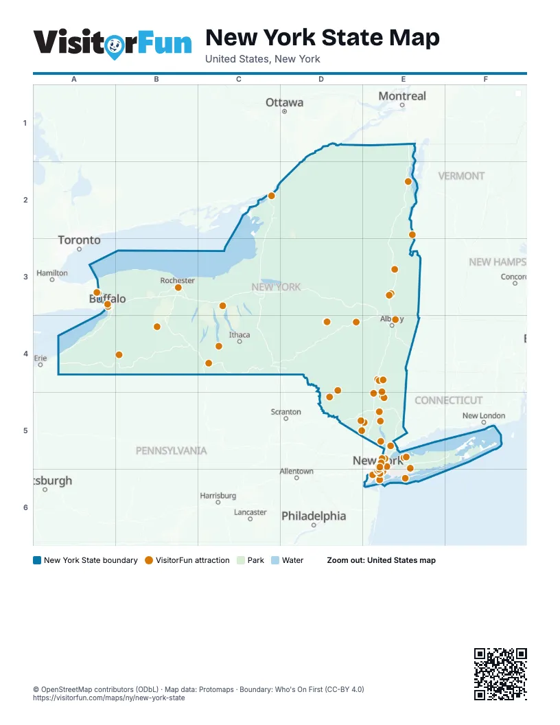
Maps inside New York State
25 maps inside, from the street map of New York State down.
Counties
- Albany County1 inside
- Bronx County
- Dutchess County3 inside
- Erie County46 inside
- Essex County2 inside
- Kings County
- Monroe County1 inside
- Nassau County3 inside
- New York County
- Niagara County1 inside
- Oneida County1 inside
- Onondaga County1 inside
- Orange County1 inside
- Otsego County2 inside
- Queens County
- Rensselaer County1 inside
- Rockland County
- Saratoga County1 inside
- Schenectady County1 inside
- Schuyler County2 inside
- Suffolk County6 inside
- Tompkins County1 inside
- Ulster County1 inside
- Westchester County4 inside
Things to do on the New York State map
- & Juliet
- 9/11 Memorial & Museum
- Adventureland
- AKA New York
- Aladdin (Broadway)
- Aloft Manhattan Downtown - Financial District
- American Museum of Natural History
- Anchor Bar
- Apollo Theater
- Applebee's Grill + Bar Times Square
- Ausable Chasm
- B&H Photo Video
- Barclays Center
- Best Western Plus Soho Hotel
- Bethel Woods Center for the Arts
- Big Bus Tours New York
- Birdland
- Blue Note Jazz Club
- Boldt Castle
- Bronx Music Hall
- Bronx Zoo
- Brooklyn Botanic Garden
- Brooklyn Bridge
- Bryant Park
- Buena Vista Social Club
- Buffalo AKG Art Museum
- Carnegie Hall
- Castle Fun Center
- Cave of the Winds
- Central Park
- Central Park Zoo
- Charging Bull
- Chelsea Market
- Chicago the Musical
- Chinatown
- Chrysler Building
- Circle Line Sightseeing Cruises
- Citi Field
- Coney Island
- Cooperstown
- Corning Museum of Glass
- Dallas BBQ Times Square
- Dave & Buster's Times Square
- Dia Beacon
- DoubleTree by Hilton New York Downtown
- Dumbo
- Dutchess County
- Edge NYC
- Empire State Building
- Fifth Avenue
- Flatiron Building
- Fort Ticonderoga
- Fraunces Tavern Museum
- General Grant National Memorial
- Governors Island
- Grand Central Terminal
- Greenwich Village
- Hadestown (Broadway)
- Hamilton
- Harlem
- Harry Potter and the Cursed Child
- Hilton New York Times Square
- Holiday Inn NYC - Lower East Side
- Holiday Valley Resort
- Home of Franklin D. Roosevelt National Historic Site
- Howe Caverns
- Hudson River Cruises
- Hudson Valley Wine & Food Fest
- Hudson Yards
- Intrepid Museum
- Intrepid Sea, Air & Space Museum
- Jones Beach State Park
- Just in Time (Broadway)
- Katz's Delicatessen
- LEGOLAND New York Resort
- Letchworth State Park
- Lincoln Center
- Little Italy
- Little Shop of Horrors (Off-Broadway)
- Lower Manhattan
- Luna Park
- Macy's Herald Square
- Madame Tussauds New York
- Madison Square Garden
- Maid of the Mist
- Maybe Happy Ending
- Metropolitan Opera
- MJ The Musical (Broadway)
- Mount Peter
- Nathan's Famous
- National Baseball Hall of Fame and Museum
- New York Aquarium
- New York Botanical Garden
- New York City
- New York City Ballet
- New York Public Library
- Niagara Falls, NY
- Oculus
- One Times Square
- One World Observatory
- Operation Mincemeat: A New Musical
- Palisades Center
- Peter Luger Steak House
- Prospect Park
- Radio City Music Hall
- Rainbow Air
- Real's Tours NYC
- Rensselaer County
- Rockefeller Center
- Sagamore Hill National Historic Site
- Saratoga Race Course
- Saratoga Spa State Park
- Shawangunk Wine Trail
- SIX: The Musical
- Snug Harbor Cultural Center & Botanical Garden
- SoHo
- Solomon R. Guggenheim Museum
- St. Patrick's Cathedral
- Staten Island Ferry
- Statue of Liberty & Ellis Island
- Stonewall National Monument
- Stranger Things: The First Shadow
- Sullivan Catskills
- SUMMIT One Vanderbilt
- The Battery
- The Book of Mormon (Broadway)
- The Frick Collection
- The Great Gatsby (Broadway)
- The High Line
- The Lion King (Broadway)
- The Lost Boys: A New Musical
- The Met Cloisters
- The Metropolitan Museum of Art
- The Museum of Broadway
- The Museum of Modern Art (MoMA)
- The Outsiders (Broadway)
- The Play That Goes Wrong
- The Plaza
- The Rocky Horror Show (Broadway)
- The Strong National Museum of Play
- The Tour at NBC Studios
- The WaterFront Center
- Titanique
- TKTS Times Square
- Top of the Rock Observation Deck
- Trinity Church
- TRYP by Wyndham New York City Times Square South
- Two Strangers (Carry a Cake Across New York)
- Ulster County
- United Nations Headquarters
- Vassar Modfest
- Vessel
- Village Vanguard
- Wall Street
- Washington Square Park
- Watkins Glen State Park
- Welcome to Harlem
- West Point
- Westchester County
- Westgate New York Grand Central
- Whitney Museum of American Art
- Wicked (Broadway)
- Women's Rights National Historical Park
- Yankee Stadium Tours
Places on the map
- Adirondack Park
- Aldrich Pond Wild Forest
- Allegany State Park
- Big Indian Wilderness
- Black River Wild Forest
- Blue Mountain Wild Forest
- Blue Ridge Wilderness
- Brasher State Forest
- Catskill Park
- Chazy Highlands Wild Forest
- Cranberry Lake Wild Forest
- Debar Mountain Wild Forest
- Delaware Wild Forest
- Dry Brook Ridge Wild Forest
- Ferris Lake Wild Forest
- Finger Lakes National Forest
- Fire Island National Seashore
- Five Ponds Wilderness
- Fort Drum
- Fulton Chain Wild Forest
- Genesee Valley Greenway State Park
- Grass River Wild Forest
- Groveland Secondary Trailway
- Hammond Pond Wild Forest
- Harlem Valley Rail Trail
- Harriman State Park
- High Peaks Wilderness
- Horseshoe Lake Wild Forest
- Hudson Highlands State Park
- Independence River Wild Forest
- Jamaica Bay Unit
- Jessup River Wild Forest
- Kaaterskill Wild Forest
- Lake George Islands Intensive Use Area
- Lake George Wild Forest
- Letchworth State Park
- Long Lake
- Minnewaska State Park Preserve
- Moose River Plains Wild Forest
- Pharaoh Lake Wilderness
Next to New York State
- Allentown map
- Concord map
- Erie
- Hamilton
- Harrisburg
- Lancaster
- Montréal
- New London
- Ottawa
- Philadelphia
- Pittsburgh
- Scranton
- Toronto
© OpenStreetMap contributors (ODbL) · Map data: Protomaps · Boundary: Who's On First (CC-BY 4.0)