

New York map
Hamilton Heights map
A printable two-page map of Hamilton Heights (Manhattan, New York), drawn by VisitorFun from OpenStreetMap. Page two is the street index: every street on the sheet with its grid square, the same list as below.
Open the map (PDF, US Letter)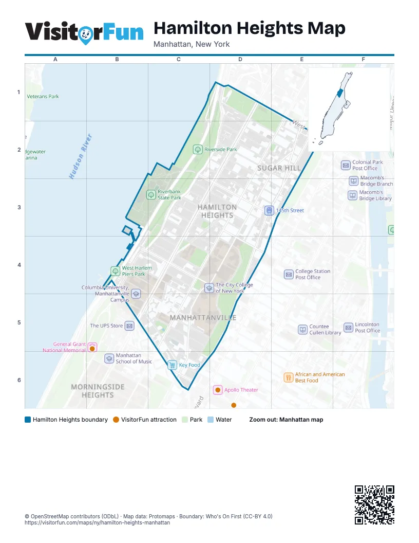
Street index of Hamilton Heights
Each street on the sheet and the grid squares it crosses.
- West 158th StreetC1, D1
- BroadwayD1, D2, C3, D3, C4, B5, C5
- Henry Hudson ParkwayD1, C2, C3, B4
- Riverside DriveD1, C2, D2, C3, B4, C4
- West 152nd StreetD1, D2, E2
- West 153rd StreetD1, D2, E2
- West 155th StreetD1, E1, E2
- Amsterdam AvenueE1, E2, C4, D4, C5
- Riverbank Park Access RoadC2, C3
- West 145th StreetC2, D3
- West 146th StreetC2, E3
- West 147th StreetC2, E3
- West 148th StreetD2, E3
- West 149th StreetD2, E2, E3
- West 150th StreetD2, E2
- West 151st StreetD2, E2
- Convent AvenueE2, D3, C4, D4, C5, C6
- Edgecombe AvenueE2, E3, D5
- Saint Nicholas AvenueE2, D3, E3, D5, C6, D6
- Saint Nicholas PlaceE2, E3
- West 154th StreetE2
- 12th AvenueC3, B4
- Hamilton PlaceC3, D3, C4
- West 137th StreetC3, C4, D4
- West 138th StreetC3, D4
- West 139th StreetC3, D4
- West 140th StreetC3, D4
- West 141st StreetC3, D3
- West 142nd StreetC3, D3, D4
- West 143rd StreetC3, D3
- West 144th StreetC3, D3
- Hamilton TerraceD3, D4
- Marginal StreetB4
- West 130th StreetB4, B5, C5
- West 131st StreetB4, C5
- West 132nd StreetB4, C4
- West 133rd StreetB4, C4, C5
- West 134th StreetB4, C4
- West 134th Street (upper)B4
- West 135th StreetB4, C4, D4, D5
- Old BroadwayC4, B5, C5
- West 136th StreetC4, D4
- Saint Nicholas TerraceD4, C5, D5, C6
- Saint Clair PlaceB5
- West 125th StreetB5, C5, C6
- West 126th StreetB5, C5, C6
- West 129th StreetB5, C5
- West 127th StreetC5
- West 128th StreetC5, C6
- Hancock PlaceC6
- Morningside AvenueC6
Places on the map
- 125th Street
- 135th Street
- 137th Street-City College
- 142nd Street Dog Run
- 145th Street
- 155th Street
- A Philip Randolph Campus High School
- Aaron Davis Hall
- Ameer Food
- C-Town
- Church of the Annunciation
- Church of the Intercession
- Citi Bike - Convent Ave & W 151 St
- Columbia University, Manhattanville Campus
- CUNY Advanced Science Research Center
- Donnellan Square
- FDNY Engine 80/Ladder 23
- Food Universe Marketplace
- Foodtown
- Frank White Memorial Garden
- Global
- Golden Deli
- Hamilton Grange Library
- Hamilton Grange National Memorial
- Hamilton Grange Station Post Office
- Hamilton Heights
- Harlem Health Center
- Harris Garden
- Hope Steven Garden
- Hope the Friendly Garden on Hill
- Jacob H. Schiff Playground
- Key Food
- Lenfest Center for the Arts
- Maggie's Garden
- Manhattan Community Board 9
- Manhattanville
- Manhattanville Houses
- Mm - Manhatanville Market
- Mo' Pals
- NYPD 26 PCT
Next to Hamilton Heights
© OpenStreetMap contributors (ODbL) · Map data: Protomaps · Boundary: Who's On First (CC-BY 4.0)