

New York map
Kips Bay map
A printable two-page map of Kips Bay (Manhattan, New York), drawn by VisitorFun from OpenStreetMap. Page two is the street index: every street on the sheet with its grid square, the same list as below.
Open the map (PDF, US Letter)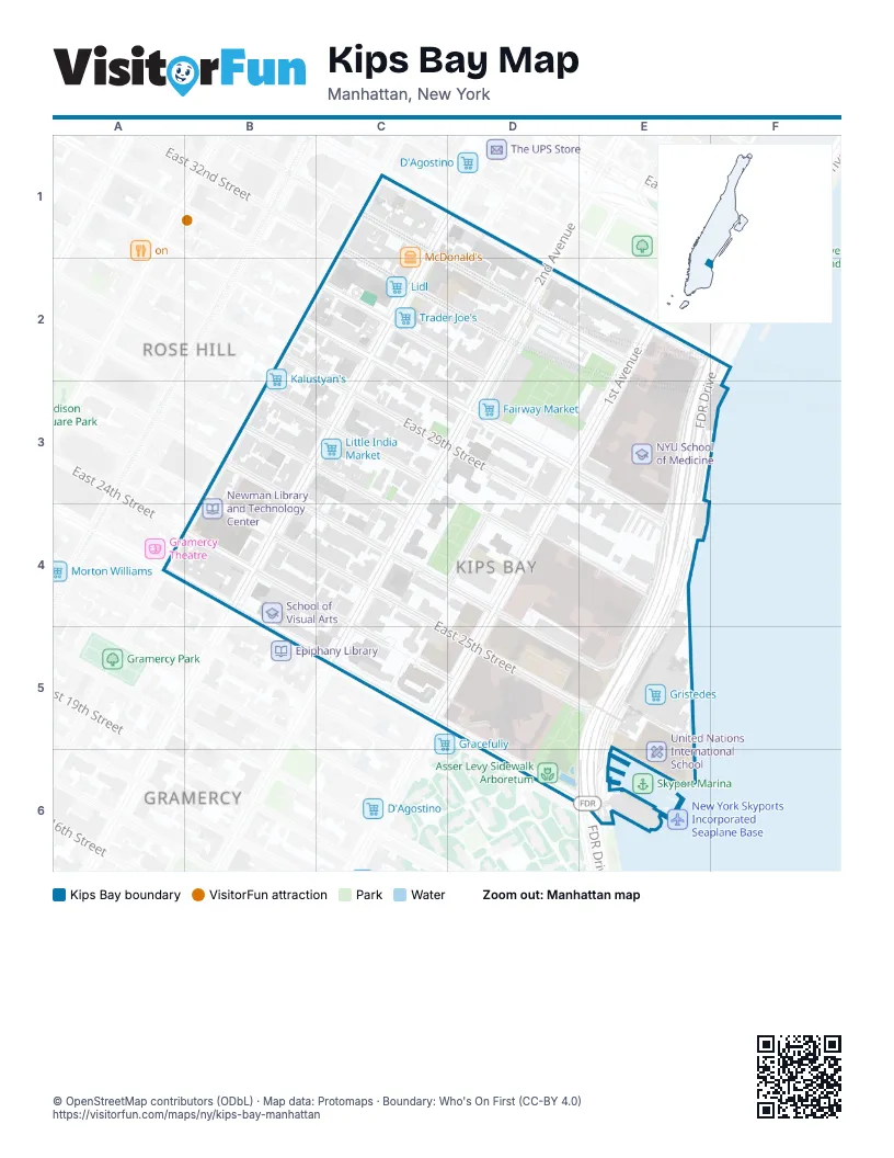
Street index of Kips Bay
Each street on the sheet and the grid squares it crosses.
- East 29th StreetB2, C3, D3, D4
- East 31st StreetC2, D2
- Windsor CourtC2
- 2nd AvenueD2, C3, C4
- 2nd Avenue service roadD2, D3
- East 32nd StreetD2
- East 33rd StreetD2, E2
- East 34th StreetD2, E2, F2
- Tunnel Approach StreetD2
- FDR DriveE2, F2, E3, E4, D5, E5, E6
- 3rd AvenueB3, B4
- East 26th StreetB3, C4, D4, D5
- East 27th StreetB3, C4
- East 28th StreetB3, C3, D4, E4
- East 30th StreetD3, E4
- East 23rd StreetB4, B5, C5, E6
- East 24th StreetB4, C4, C5, D5
- East 25th StreetB4, D5, E5
- Mount Carmel PlaceD4
- 1st AvenueD5
- East 23rd Street Access RoadD5, D6
- Waterside PlazaE5, E6
- Avenue CE6
Places on the map
- Asser Levy Playground
- Asser Levy Recreation Center
- Asser Levy Sidewalk Arboretum
- Bellevue South Park
- Chapel of the Sacred Hearts of Jesus & Mary
- Congregation Talmud Torah Adereth El
- D'Agostino
- East Midtown Plaza
- East River Tunnel ventilation building
- Episcopal Church of the Good Shepherd
- Fairway Market
- FDNY Engine 16/Ladder 7
- First Christian Church Of The Valley
- Gristedes
- Hansjörg Wyss Department of Plastic Surgery
- Kalustyan's
- Kips Bay
- Kips Bay Plaza
- Lidl
- Little India Market
- Madison Square Station New York Post Office
- Manhattan Community Board 6
- McDonald's
- Morton Williams
- Nathan Straus Houses
- New York Skyports Incorporated Seaplane Base
- Newman Library and Technology Center
- NYC Health + Hospitals/Bellevue
- NYC PEV
- NYU Langone Health - Tisch Hospital
- NYU Langone Parking Lot D
- NYU School of Medicine
- P.S. 116 - Mary Lindley Murray School
- Perlmutter Cancer Center
- Red Ball Garage
- School of Visual Arts
- Skyport
- St. Illuminator
- Target
- The Remnant Presbyterian Church
Next to Kips Bay
- Gramercy map
- Rose Hill
© OpenStreetMap contributors (ODbL) · Map data: Protomaps · Boundary: Who's On First (CC-BY 4.0)