

New York map
Lighthouse Hill map
A printable two-page map of Lighthouse Hill (Staten Island, New York), drawn by VisitorFun from OpenStreetMap. Page two is the street index: every street on the sheet with its grid square, the same list as below.
Open the map (PDF, US Letter)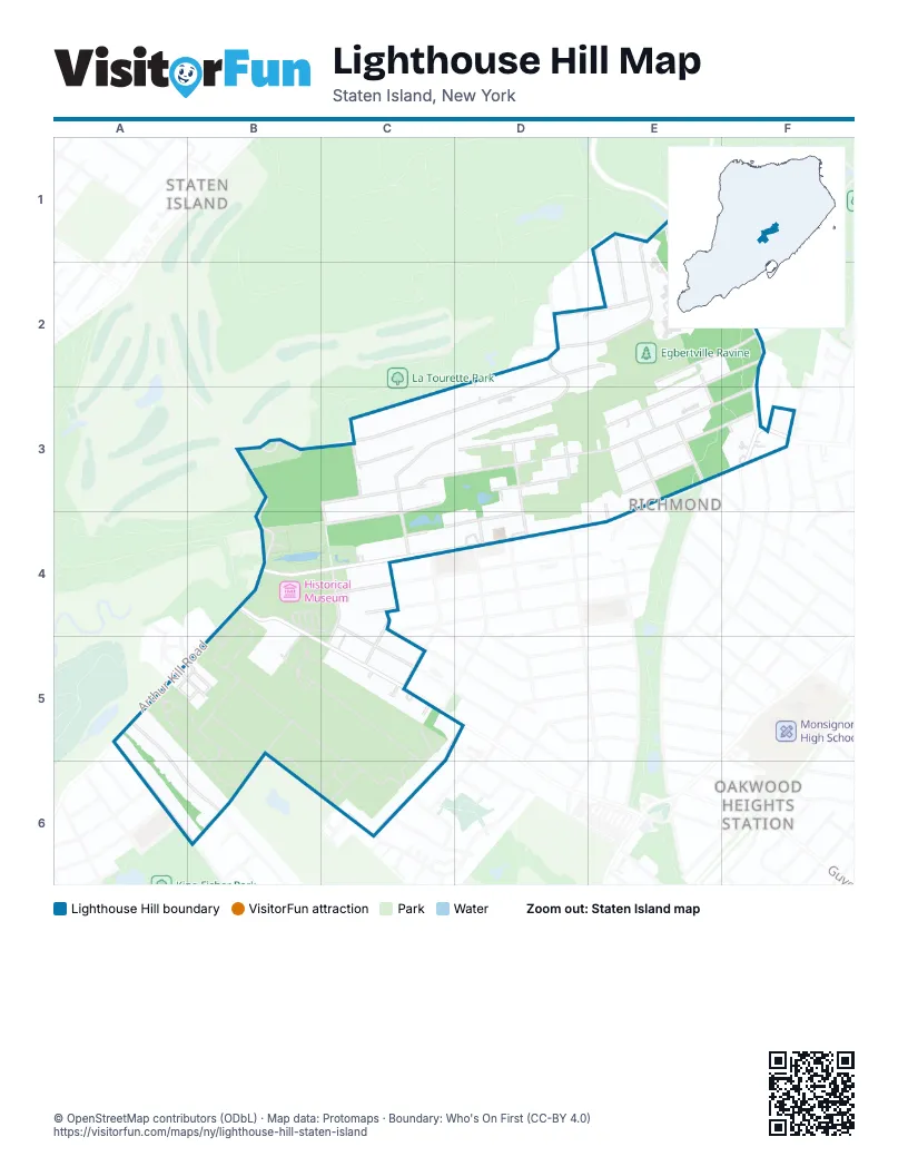
Street index of Lighthouse Hill
Each street on the sheet and the grid squares it crosses.
- Burton CourtE1, F1
- Kent StreetE1, E2
- Manor RoadE1
- Meisner AvenueE1, D2, E2
- Rockland AvenueE1, F2, F3
- Chance AvenueF1
- Florida TerraceF1, E2
- Nevada AvenueF1, F2
- Sloane AvenueF1
- Edinboro RoadD2, E2, B3, C3, D3
- Lighthouse AvenueD2, C3, D3, C4
- London RoadD2, C3
- Lowell StreetD2
- Meeker StreetD2
- Scheffelin AvenueD2, E2
- Terrace CourtD2, D3
- Winsor AvenueD2, D3
- Eleanor StreetE2, F2
- Esther Depew StreetE2
- Lawn AvenueE2, E3
- Nugent StreetE2, F2, D3, E3
- Charles CourtF2
- Tonking RoadF2
- Richmond Hill RoadB3, C3, B4, C4
- Manor CourtC3
- Rigby AvenueC3
- Saint Andrews RoadC3, D3, E3, F3, C4
- Saint George RoadC3, D3, E3, F3
- Ascot AvenueD3
- Aultman AvenueD3, D4
- Boyle PlaceE3
- Hitchcock AvenueE3
- Mace StreetE3, C4, D4
- McCully AvenueE3
- Tupelo CourtE3
- Cranford AvenueF3
- Milburn StreetF3
- Morley AvenueF3
- Nadine StreetF3
- Richmond RoadF3, B4, C4, D4
- Arthur Kill RoadB4, A5
- Clarke AvenueB4, B5, C5
- Old Mill RoadB4
- Ardsley StreetC4
- Center StreetC4
- Gilbert StreetC4, C5
- McKinley AvenueC4, C5
- Moore StreetC4
- Saint Patricks PlaceC4, C5
- Thomas StreetC4
- West Cedarview AvenueC4, C5
- Kensico StreetD4
- Spruce StreetD4
- Santo CourtE4
- Chess LoopA5, B5
- Knight LoopA5, B5
- Newvale AvenueA5, B5
- Tanglewood DriveA5, A6, B6
- Boyce AvenueC5
- Cotter AvenueC5, C6
- Dylan WayC5
- Gianna CourtC5
- Joshua CourtC5
- Corbin AvenueA6, B6
- Daleham StreetA6
- Elkhart StreetA6
- Fairfield StreetA6
- Teakwood CourtB6
- Blythe PlaceC6
- Dina CourtC6
- Luke CourtC6
Places on the map
- Amazing Games TCG
- Arthur Kill Road & Center Street
- Arthur Kill Road & Corbin Avenue
- Arthur Kill Road & Newvale Avenue
- Arthur Kill Road & United Hebrew Cemetery Gate
- Barger Privy
- Barn Foundation
- Basketmaker's House
- Bennett House
- Britton Cottage
- Carpenter Shop
- Carriage House
- Carriage Manufactory
- Casa Verde Ristorante Italiano
- Classic Bagels Deli
- Classic Pizza
- Community Resources Chilren's Campus
- Crocheron House
- Dunn's Mill
- Edwards-Barton House
- Egbertville Ravine
- First County Jail
- General Store
- Gourmet Chef
- GS Sarah Nail
- Guyon Store
- Guyon-Lake-Tysen House
- Historic Richmond Town
- Historical Museum
- Iwarelove By Sara
- Jacques Marchais Museum of Tibetan Art
- Journeay Privy
- Kruser-Finley House
- Lava Nails
- Main Street Coffee
- Mark's Bake Shoppe
- Mill Pond
- Mount Richmond Cemetery
- Nevermore Tattoos
- New Dorp Railroad Station
Next to Lighthouse Hill
- Oakwood Heights Station
- Richmond
- Staten Island map
© OpenStreetMap contributors (ODbL) · Map data: Protomaps · Boundary: Who's On First (CC-BY 4.0)