

New York map
Morris Heights map
A printable two-page map of Morris Heights (The Bronx, New York), drawn by VisitorFun from OpenStreetMap. Page two is the street index: every street on the sheet with its grid square, the same list as below.
Open the map (PDF, US Letter)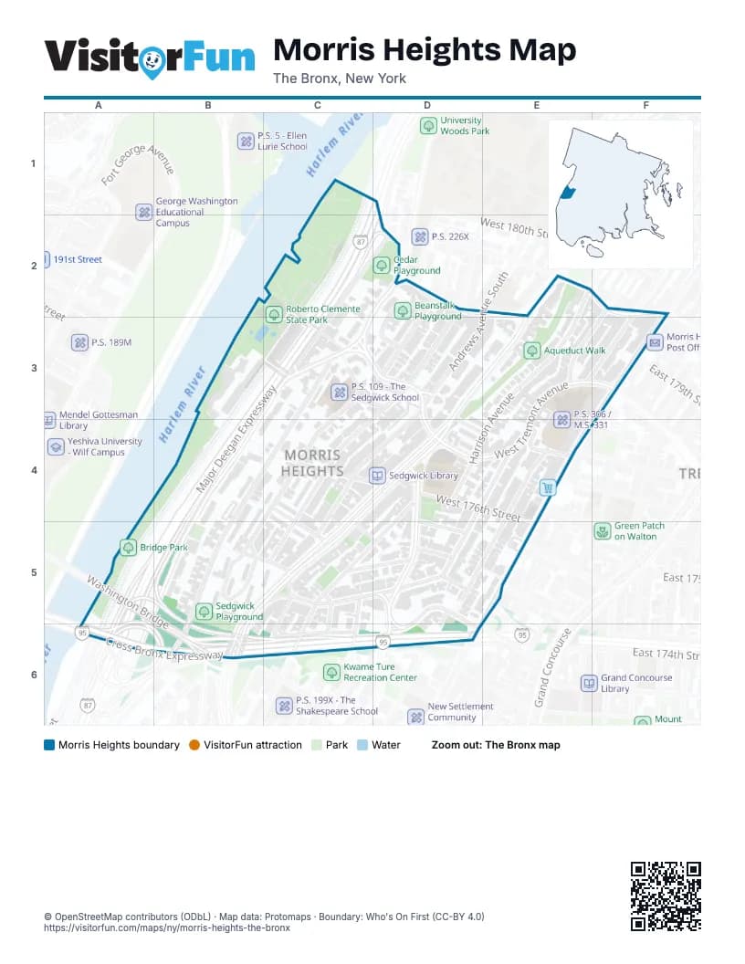
Street index of Morris Heights
Each street on the sheet and the grid squares it crosses.
- Major Deegan ExpresswayC1, D1, C2, D2, B3, C3, B4, A5, B5
- Cedar AvenueC2, D2, C3
- Fordham PlaceC2, C3
- Matthewson RoadC2, C3
- West Tremont AvenueC2, C3, D3, E3, F3, D4, E4
- Billingsley TerraceD2, D3
- Hennessy PlaceD2
- Phelan PlaceD2, D3
- Sedgwick AvenueD2, C3, B4, B5
- West 179th StreetD2
- West Burnside AvenueD2, E2, F2
- Harrison AvenueE2, E3, D4, E4
- University AvenueE2, D3, E3, D4, B5, C5, B6
- Grand AvenueF2, E3, E4, D5
- Jerome AvenueF2, F3, E4, E5, D6
- Richman PlazaB3, C3
- Palisade PlaceC3
- Popham AvenueC3, D3, C4, B5
- Roberto Clemente State Park BridgeC3
- Undercliff AvenueC3, B4, B5, B6
- Andrews Avenue SouthD3, C4, D4, C5
- Loring Place SouthD3
- Montgomery AvenueD3, C4, C5
- Morton PlaceD3, E4
- Davidson AvenueE3, E4, D5, E5
- Kingsland PlaceE3
- East 179th StreetF3
- East Tremont AvenueF3
- Brandt PlaceC4, D5
- Tenney PlaceC4, C5
- West 175th StreetC4, D4, C5, D5
- West 176th Step StreetC4, D4
- Macombs RoadD4, D5, D6
- Nelson AvenueD4, C5, D5, C6
- West 176th StreetD4, E4
- East 176th StreetE4
- East 177th StreetE4
- Mount Hope PlaceE4
- West 177th StreetE4
- Washington BridgeA5, B6
- West 174th StreetB5, C5, D5
- Featherbed LaneC5, D5, D6
- Jesup AvenueC5, C6
- Plimpton AvenueC5, C6
- Shakespeare AvenueC5, C6
- Inwood AvenueD5, D6
- Clifford PlaceE5
- East 175th StreetE5
- Cross Bronx ExpresswayA6, B6, C6, D6
- Major Deegan Entrance NorthboundA6
- Cross Bronx Expressway Service RoadC6
- East 174th StreetD6
- West Mount Eden AvenueD6
Places on the map
- 176th Street
- 1872 University Avenue
- 1875 University Avenue
- Academy For Language And Technology
- Aqueduct Walk
- Aqueduct Walk (Morten to West Burnside)
- Aqueduct Walk (Tremont to Morton)
- Beanstalk Playground
- Brandt Park
- Bridge Park
- Burnside Avenue
- Calvary Methodist Church
- Car Leasing Deals
- Cedar Playground
- CIS 303 - The Leadership and Community Service Academy
- Citi Bike - Davidson Ave & W Burnside Ave
- Citi Bike - Featherbed Ln & Jerome Ave
- Citi Bike - Featherbed Ln & Nelson Ave
- Citi Bike - Jerome Ave & W 177 St
- Citi Bike - Macombs Rd & Featherbed Ln
- Citi Bike - Macombs Rd & W 175 St
- Citi Bike - Popham Ave & W 174 St
- Citi Bike - Sedgwick Ave & W Tremont Ave
- Citi Bike - University Ave & Brandt Pl
- Citi Bike - University Ave & Macombs Rd
- Citi Bike - University Ave & Morton Pl
- Citi Bike - W 176 St & Montgomery Ave
- Citi Bike - W Tremont Ave & Grand Ave
- Citi Bike - W Tremont Ave & Matthewson Rd
- Citi Bike - W Tremont Ave & Montgomery Ave
- FDNY Engine 43/Ladder 59
- Featherbed Lane Presbyterian Church
- Featherbed Triangle
- Featherbenches
- Galileo Park
- Half-Nelson Playground
- Harlem River Park Towers
- Hayden Lord Park
- Hing Wong Chinese Restaurant
- Holy Spirit Catholic Church
© OpenStreetMap contributors (ODbL) · Map data: Protomaps · Boundary: Who's On First (CC-BY 4.0)